Ruta Circular Pirineos 3 Días: Guía Completa de Trekking
Introducción
Una ruta circular de tres días por el Pirineo es la escapada perfecta para desconectar sin alejarte demasiado tiempo. Esta guía te lleva por el Valle de Benasque, uno de los rincones más espectaculares del Pirineo aragonés, con ibones de aguas cristalinas, refugios de montaña acogedores y paisajes que cortan la respiración. El itinerario circular te permite volver al punto de partida sin deshacer camino, visitando el Refugio de Estós, el Ibonet de Batisielles y el Refugio de La Renclusa. Con una dificultad media-alta y un desnivel acumulado de unos 2.800 metros en total, es una ruta accesible para senderistas con algo de experiencia. Aquí encontrarás toda la información práctica: mapa detallado, reserva de refugios, qué llevar en la mochila y cómo moverte por la zona. Si buscas una aventura de montaña auténtica, lejos del asfalto y cerca de las cumbres, esta ruta te espera.
Picuco te puede ayudar
Does something here catch your eye?
Tell us.
Write to us on WhatsApp or email: we answer questions, find the best options and help you sort out the booking.
Por Qué Esta Ruta Circular es Perfecta en 3 Días
Equilibrio entre Esfuerzo y Paisaje
Tres días es el tiempo justo para adentrarte en la montaña sin la prisa de una excursión de un día ni el compromiso de una semana entera. Cada jornada tiene entre 5 y 7 horas de marcha, lo que te deja tiempo para disfrutar del paisaje, hacer fotos en los ibones y llegar al refugio sin agobios. El formato circular te ahorra la logística de organizar transporte de vuelta: empiezas y terminas en el mismo punto, con tu coche esperándote. El Valle de Benasque concentra en poco espacio una variedad de terrenos impresionante: bosques de pino negro, praderas alpinas, morrenas glaciares, ibones de alta montaña y vistas a tresmiles como el Aneto o la Maladeta. Según datos del Parque Natural Posets-Maladeta, esta zona recibe más de 80.000 visitantes al año, pero la mayoría se queda en rutas de un día, así que dormir en refugio te aleja de las aglomeraciones.
Refugios de Montaña con Encanto
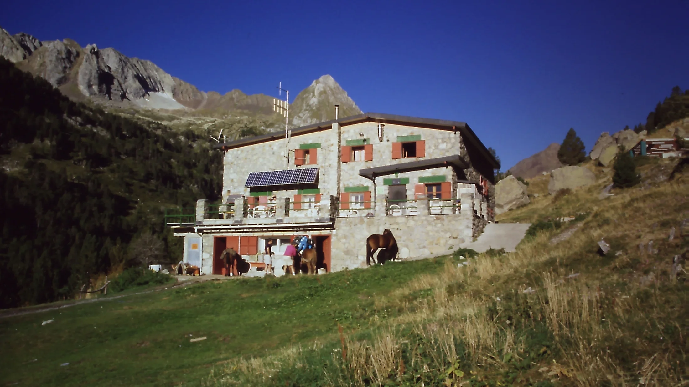
Los dos refugios de esta ruta —Estós y La Renclusa— son auténticas casas de montaña donde compartes mesa, conversación y el cansancio del día con otros caminantes. Nada de hoteles impersonales: aquí cenas a las 20:30 en literas compartidas, con mantas de lana y el olor a sopa caliente. El Refugio de Estós (1.890 m) está gestionado por la familia Mur desde hace décadas, con cocina casera y ambiente familiar. El Refugio de La Renclusa (2.140 m), guardado por la Federación Aragonesa de Montañismo, es el refugio más grande del Pirineo aragonés, con capacidad para 120 personas y vistas directas al Aneto. Ambos refugios exigen reserva obligatoria (659 076 688 para Estós; 974 553 158 para La Renclusa), especialmente en julio y agosto, cuando se llenan con 2-4 semanas de antelación. Dormir en refugio es parte esencial de la experiencia: te acuestas al ritmo del sol y te despiertas con el amanecer sobre las cumbres.
Itinerario Día a Día: Detalles de Cada Etapa
Día 1: Benasque → Refugio de Estós (5h, +900m)
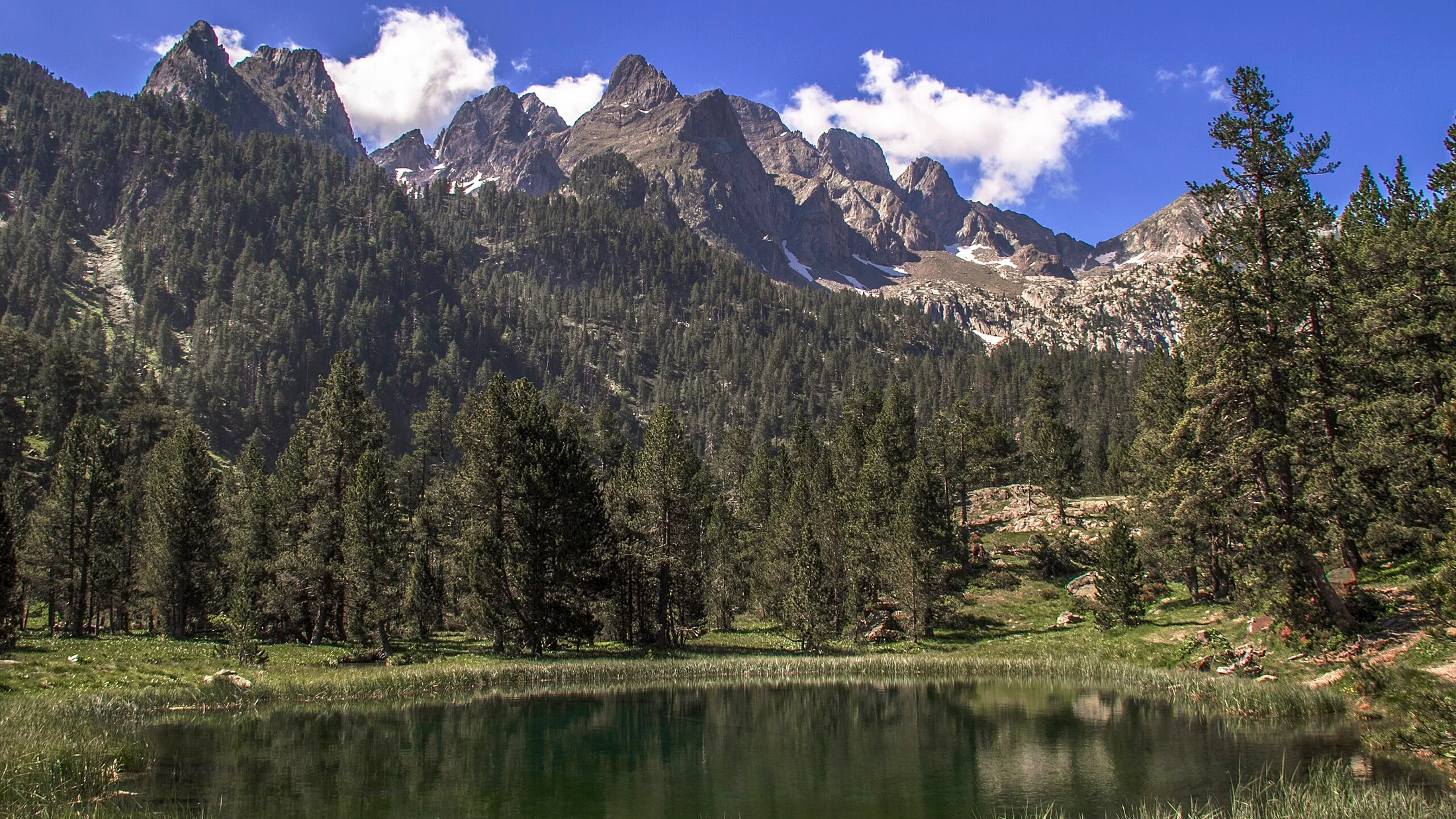
Arrancas desde el aparcamiento de La Besurta (1.900 m), al final de la carretera que sube desde Benasque. Los primeros 40 minutos discurren por un bosque denso de pino negro, con el río Ésera sonando a tu izquierda. El sendero es ancho, bien marcado con hitos de piedra y señales GR-11. A medida que ganas altura, el bosque se abre y aparecen las praderas del valle de Estós, con vistas al pico Perdiguero (3.222 m) cerrando el horizonte. El Refugio de Estós aparece tras un pequeño repecho, rodeado de pinos y con una terraza soleada donde los guardas secan las setas en otoño. Si llegas antes de las 17:00, tienes tiempo de subir hasta el Ibón de Batisielles (30 min más), un lago de aguas turquesas encajado entre paredes de roca. La cena se sirve a las 20:30: sopa, segundo contundente (estofado o pasta) y postre casero. Precio: incluido en la tarifa de refugio (media pensión unos 40€/persona).
Día 2: Estós → Ibonet de Batisielles → Refugio de La Renclusa (7h, +1.100m)
Esta es la etapa reina, la más larga y exigente. Sales del refugio de madrugada (7:00-7:30) con el frontal puesto si es verano. El sendero trepa por la Canal de Batisielles, una subida sostenida de 1 hora hasta el collado (2.520 m), donde el valle se abre y aparece el Ibonet de Batisielles, un ibón diminuto pero fotogénico, con el macizo del Aneto al fondo. Desde el collado, desciendes al Valle de la Escaleta, un descenso pedregoso que requiere atención en los tobillos. A media mañana llegas al Puente de Coronas, donde el GR-11 se cruza con el camino que sube a La Renclusa. La subida final es larga pero gradual, zigzagueando por un valle glaciar con vistas a la Maladeta. El Refugio de La Renclusa aparece como un edificio grande de piedra, con la bandera del Pirineo ondeando en el tejado. Llegas sobre las 14:00-15:00, a tiempo para comer (bocadillo de tu mochila o menú en el refugio si has reservado). La tarde la pasas descansando, explorando los alrededores o subiendo hasta el Plan de Aigualluts para ver las cascadas y el nacimiento del río Garona.
Día 3: La Renclusa → La Besurta → Benasque (4h, -800m)
El último día es más relajado, casi todo en bajada. Sales del refugio tras desayunar (7:30-8:00) y desciendes por el camino ancho que baja al Valle de Benasque, pasando por el Hospital de Benasque (ruinas de un antiguo hospital de peregrinos) y los Llanos del Hospital, una pradera verde donde pastan vacas en verano. El sendero se convierte en pista forestal al llegar a La Besurta, donde recuperas el coche. Si te quedan fuerzas, puedes alargar la ruta pasando por el Forau de Aigualluts, un sumidero kárstico donde el río desaparece bajo tierra para reaparecer en el Valle de Arán. Total de la ruta: unos 35 km y 2.800 m de desnivel acumulado positivo en 3 días.
Mapa y Waypoints Clave
Puntos de Referencia GPS
- La Besurta (inicio/fin): 42.6847° N, 0.6258° E (1.900 m)
- Refugio de Estós: 42.6589° N, 0.6142° E (1.890 m)
- Collado de Batisielles: 42.6456° N, 0.6089° E (2.520 m)
- Puente de Coronas: 42.6378° N, 0.6312° E (2.150 m)
- Refugio de La Renclusa: 42.6492° N, 0.6458° E (2.140 m)
- Hospital de Benasque: 42.6712° N, 0.6389° E (1.750 m)
Recomendamos descargar el track GPX en Wikiloc (busca "Circular Benasque 3 días") y llevarlo en tu móvil con la app offline. El mapa imprescindible es el Alpina E-25 "Aneto-Maladeta" (escala 1:25.000), que cubre toda la zona con curvas de nivel detalladas. En los refugios suelen vender estos mapas, pero mejor comprarlo antes en tiendas especializadas o en la oficina de turismo de Benasque.
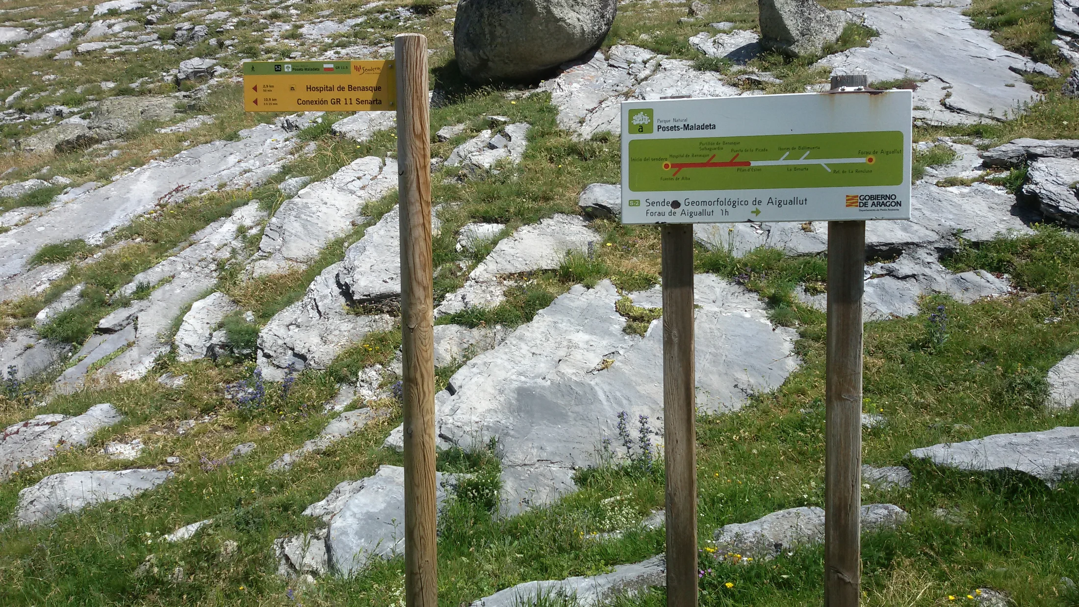
Señalización y Orientación
El GR-11 (sendero transpirenaico) cruza toda la ruta y está marcado con rayas rojas y blancas en rocas y árboles. La señalización es buena en general, pero en zonas de nieve o niebla conviene usar GPS. Los hitos de piedra (montoncitos de rocas) marcan el camino en las zonas sin vegetación. Si te desvías, vuelve al último hito visible y reoriéntate. En la Canal de Batisielles y el descenso a la Escaleta, el terreno es más técnico y requiere concentración, especialmente con mochila cargada.
Importante
Este itinerario es orientativo. Los tiempos y distancias pueden variar según las condiciones meteorológicas, tu condición física y experiencia. Evalúa tus capacidades antes de iniciar la ruta. La montaña puede ser peligrosa - ve siempre preparado y con el material adecuado. No nos hacemos responsables de accidentes o incidencias.
Refugios: Reserva, Servicios y Consejos
Refugio de Estós: Información Práctica
- Altitud: 1.890 m
- Plazas: 60 (literas compartidas)
- Contacto: 659 076 688 (WhatsApp disponible)
- Horario cena: 20:30
- Servicios: Duchas de agua caliente (2€), WiFi básico, carga de móviles, tienda con bebidas y snacks
- Reserva: Obligatoria, especialmente julio-agosto. Reservar con 2-4 semanas de antelación.
- Precio aproximado: 18€/noche (solo pernocta), 40€ (media pensión: cena + desayuno + pernocta)
El refugio abre de junio a octubre, según condiciones de nieve. Fuera de temporada (mayo, noviembre) puede abrir fines de semana si hay demanda, pero conviene llamar antes. La cocina es casera y generosa: no te quedas con hambre. Si eres vegetariano o tienes alergias, avisa al reservar.
Refugio de La Renclusa: Información Práctica
- Altitud: 2.140 m
- Plazas: 120 (literas en habitaciones de 4-8 personas)
- Contacto: 974 553 158 / info@renclusa.com
- Horario cena: 20:30
- Servicios: Duchas (3€), WiFi en comedor, bar con terraza, tienda con material de montaña, enfermería básica
- Reserva: Obligatoria, especialmente julio-agosto. Reservar con 2-4 semanas de antelación.
- Precio aproximado: 20€/noche (solo pernocta), 45€ (media pensión)
La Renclusa es el refugio base para subir al Aneto (la cumbre más alta del Pirineo, 3.404 m), así que en verano hay mucho ambiente de alpinistas. El refugio tiene tres plantas, con comedores amplios y vistas espectaculares desde la terraza. La ducha caliente después de 7 horas de marcha es un lujo que merece la pena pagar.
¿Cuándo Reservar Refugios?
Los refugios de montaña se llenan rápido en temporada alta. Si planeas ir en julio, agosto o puentes festivos (Semana Santa si no hay nieve, 15 de agosto), reserva con un mínimo de 2-4 semanas de antelación. En junio y septiembre hay más flexibilidad, pero no te confíes: un fin de semana soleado puede llenar cualquier refugio. Si los refugios están llenos, puedes llevar tienda de campaña (permitido acampar cerca de los refugios en zonas señalizadas), pero es menos cómodo y añade peso a la mochila.
Qué Llevar: Lista de Material Esencial
Ropa y Calzado
- Botas de trekking con tobillo alto y suela Vibram (terreno pedregoso)
- Mochila 40-50 litros con cubreimpermeable
- Ropa de capas: camiseta técnica, forro polar, cortavientos impermeable
- Pantalón de montaña largo (evita vaqueros)
- Gorro y guantes (incluso en verano puede nevar en collados)
- Gafas de sol y gorra para sol de alta montaña
- Ropa de recambio para dormir en refugio (los sacos de dormir no son obligatorios, los refugios dan mantas)
Material Técnico y Seguridad
- Bastones de trekking (reducen impacto en rodillas en bajadas)
- Frontal con pilas de repuesto (madrugones y lectura en litera)
- Botiquín básico: tiritas, antiinflamatorio, protector solar (factor 50), repelente de insectos
- Móvil cargado con GPX descargado y batería externa
- Silbato (señal de emergencia en montaña: 3 pitidos = SOS)
- Manta térmica (pesa 50 gramos, puede salvar vidas)
Comida y Agua
- Cantimplora o camel-bag con mínimo 1,5 litros (rellenar en refugios y fuentes del camino)
- Pastillas potabilizadoras (opcional, el agua de fuentes de montaña suele ser potable, pero mejor prevenir)
- Snacks energéticos: frutos secos, barritas, chocolate, fruta deshidratada
- Bocadillos para el camino (los refugios preparan bocadillos si avisas la noche antes, 5-6€)
No necesitas llevar hornillo ni comida para cocinar: los refugios dan cena y desayuno, y puedes comprar bocadillos allí. Esto te ahorra peso en la mochila, que se agradece en las subidas.
Mejor Época para la Ruta Circular
Verano: Julio y Agosto
Son los meses con mejor tiempo y mayor afluencia de gente. Las temperaturas en los refugios rondan los 15-20°C de día, bajando a 5-10°C de noche. Los ibones están libres de hielo y el agua tiene ese color turquesa intenso. Inconveniente: refugios llenos, senderos más transitados, tormentas eléctricas por la tarde (común en Pirineos). Si vas en agosto, sal pronto de madrugada para llegar a los collados antes de las 14:00, cuando se forman nubes.
Junio y Septiembre: Temporada Ideal
Menos gente, refugios más tranquilos, precios a veces más bajos. En junio todavía puede haber neveros en la Canal de Batisielles (requiere crampones ligeros o microspikes), pero el paisaje es espectacular con las flores alpinas brotando. Septiembre es perfecto: tiempo estable, temperaturas suaves, colores otoñales en los bosques. Los refugios cierran a mediados de octubre, así que confirma fechas antes de ir.
Primavera y Otoño Avanzado: Solo para Expertos
De abril a mayo y de noviembre en adelante, la ruta requiere experiencia en nieve, crampones, piolet y conocimiento de orientación invernal. Los refugios suelen estar cerrados (aunque La Renclusa a veces abre el "refugio de invierno", una zona sin guardia con literas básicas). Solo recomendable para montañeros experimentados.
Activities near Pirineos
Discover more activities near Pirineos. See options →
Nivel de Dificultad y Preparación Física
¿Para Quién es Esta Ruta?
Dificultad: Media-Alta. No es una ruta para principiantes absolutos, pero tampoco necesitas ser atleta. Si haces senderismo con regularidad (al menos una vez al mes), tienes buena forma cardiovascular y no te asustan las subidas largas, esta ruta es para ti. El desnivel total (2.800 m en 3 días) se reparte de forma que ningún día es insuperable, pero la etapa del día 2 es exigente: 7 horas con mochila cargada. Si dudas de tu forma física, considera contratar un guía de montaña que ajuste el ritmo y te asesore.
Entrenamiento Previo
Dos meses antes, empieza a caminar con mochila cargada (10-12 kg) por senderos con desnivel. Sube escaleras, haz rutas de día por sierras cercanas (Guadarrama, Gredos, Picos de Europa...). Fortalece tobillos y rodillas: el terreno pedregoso del Pirineo castiga las articulaciones. Si no estás acostumbrado a dormir en refugio, prueba antes en alguna ruta de fin de semana para saber cómo reacciona tu cuerpo al esfuerzo continuado.
Seguridad en Montaña: Consejos Clave
Meteorología y Tormentas
Consulta el parte meteorológico antes de salir (AEMET tiene predicción específica para Pirineos) y cada mañana pregunta al guarda del refugio. Las tormentas eléctricas en verano son peligrosas en collados y cimas: si ves nubes negras acercándose, desciende inmediatamente a zonas bajas, aléjate de crestas y evita refugiarte bajo árboles aislados. Si te pilla una tormenta en campo abierto, agáchate sobre tus talones (posición fetal), separando los pies del suelo lo máximo posible, y espera a que pase.
Mal de Altura y Hidratación
Aunque no se alcanzan altitudes extremas, algunas personas sensibles pueden notar leve mal de altura por encima de 2.500 m (dolor de cabeza, náuseas). Bebe agua constantemente (al menos 2-3 litros al día), come algo cada 2 horas y no fuerces el ritmo: camina despacio y respira hondo. Si los síntomas empeoran, desciende inmediatamente.
Emergencias y Rescate
En caso de accidente, llama al 112 (emergencias general) o al 062 (Guardia Civil – GREIM, especialistas en rescate de montaña). Da tu posición GPS exacta, describe la situación y sigue las instrucciones. Los refugios tienen botiquín y personal entrenado en primeros auxilios. El helicóptero de rescate opera desde Benasque, pero las condiciones meteorológicas pueden retrasar la intervención: la prevención es siempre mejor que la cura.
Cómo Llegar al Valle de Benasque
Desde Madrid (500 km, 5h)
Toma la A-2 dirección Zaragoza, luego la A-23 hacia Huesca y sigue hasta Graus. Desde Graus, la A-139 te lleva directamente a Benasque (45 min de curvas). La carretera está bien asfaltada, pero ten cuidado con el tráfico de fines de semana en verano.
Desde Barcelona (300 km, 3h30)
A-2 dirección Lleida, luego N-230 hacia el túnel de Vielha. Antes de llegar al túnel, toma el desvío hacia Benasque por la N-230a. Ruta alternativa: por el Túnel de Vielha y bajar por el Valle de Arán, pero es más larga.
Transporte Público
Hay autobuses desde Zaragoza y Lleida hasta Benasque (compañía Alosa), pero con frecuencia limitada (1-2 al día). Desde Benasque, en verano hay un servicio de bus al aparcamiento de La Besurta (consultar horarios en la oficina de turismo de Benasque), lo que te ahorra subir los últimos 8 km por carretera estrecha.
Alternativas y Extensiones de la Ruta
Añadir el Aneto (Día Extra)
Si te sobra un día y tienes experiencia en alta montaña, desde La Renclusa puedes subir al Aneto (3.404 m), la cumbre más alta del Pirineo. Requiere crampones, piolet, arnés y conocimientos de glaciar (el paso de la Mahoma es un pequeño glaciar con grietas). Tiempo: 8-10h ida y vuelta desde La Renclusa. Si no tienes experiencia, contrata un guía certificado: la montaña no perdona errores.
Ruta Más Corta: 2 Días sin Renclusa
Si solo dispones de un fin de semana, puedes hacer una versión reducida: Benasque → Refugio de Estós (día 1), Estós → Ibonet de Batisielles → vuelta a La Besurta por el mismo camino (día 2). Pierdes la parte circular y la visita a La Renclusa, pero sigues disfrutando de los ibones y el Valle de Estós.
Combinación con Valle de Arán
Desde el Refugio de La Renclusa, puedes cruzar al Valle de Arán por el Puerto de la Picada (2.475 m) y bajar a Artés de Lin o Salardú. Esto convierte la ruta en lineal (necesitas organizar transporte de vuelta o dejar un coche en cada extremo), pero añade variedad de paisajes y pueblos con encanto.
Dónde Comer y Dormir en Benasque (Pre y Post Ruta)
Antes y después de la ruta, Benasque pueblo ofrece opciones para celebrar o recuperarte. Hotel Ciria (3 estrellas, céntrico, con spa) es ideal para darte un capricho post-trekking. Restaurante El Fogaril sirve cocina aragonesa contundente: ternasco, migas, chireta. Para tapear, Bar Avellanas tiene croquetas caseras y vinos del Somontano. Si buscas algo más económico, Camping Aneto está a 2 km del pueblo, con bungalows y zona de barbacoas.
Impacto Ambiental y Montañismo Responsable
El Pirineo es un espacio natural protegido: respeta las normas del Parque Natural Posets-Maladeta. No dejes basura (ni cáscaras de naranja: tardan meses en descomponerse en alta montaña), usa los baños de los refugios (no hagas tus necesidades cerca de ibones o fuentes), y mantente en los senderos marcados para evitar erosionar el terreno. Los ibones son ecosistemas frágiles: no te bañes en ellos (el jabón y protector solar contaminan el agua). Si ves basura abandonada, recógela aunque no sea tuya: la montaña es de todos y entre todos la cuidamos.
Presupuesto Total: ¿Cuánto Cuesta la Ruta?
Estimación para 1 Persona (3 Días)
- Refugios (2 noches en media pensión): 80-90€
- Comidas extra (bocadillos, snacks): 20-25€
- Gasolina (ida y vuelta desde Madrid, ejemplo): 60€
- Aparcamiento La Besurta: Gratuito (parking público)
- Material (si no tienes nada): 200-400€ (botas, mochila, bastones... pero es inversión amortizable)
- Seguro de montaña (FEDME o similar): 50€/año (opcional pero recomendable)
Total ruta sin material: 160-175€ por persona. Si vais en grupo y compartís coche, el gasto baja. Si contratas un guía de montaña (recomendable si es tu primera ruta de varios días), el precio sube a 150-250€/persona en grupos de 4-6 personas, pero incluye seguridad, experiencia y anécdotas de alguien que conoce cada piedra del valle. Reserva guía de montaña para tu ruta en Picuco si prefieres ir acompañado por un profesional.
Conclusión: Tu Aventura de 3 Días en el Pirineo
Una ruta circular de tres días por el Valle de Benasque es mucho más que kilómetros y desnivel: es el privilegio de despertarte con el sol iluminando el Aneto, compartir mesa con desconocidos que acaban siendo compañeros de cordada, y volver a casa con las piernas cansadas pero el alma recargada. Los ibones, los refugios, las cumbres nevadas y el silencio de la alta montaña te esperan a solo unas horas de las grandes ciudades. Con la preparación adecuada, reservas hechas con tiempo y respeto por el entorno, esta ruta se convierte en una de esas experiencias que cuentas años después. Así que carga la mochila, ajusta las botas, y deja que el Pirineo te enseñe por qué la montaña engancha. Encuentra guías, alojamientos y experiencias en el Pirineo en Picuco para planificar cada detalle de tu aventura.