The essentials of Collserola Natural Park

  • • Carretera de les Aigües: flat 9 km path at 300 m elevation with views over Barcelona and the Mediterranean
  • • Over 130 documented bird species, from sparrowhawks to tawny owls
  • • Direct access on foot from neighbourhoods like Vallvidrera, Les Planes and La Floresta
  • • Medieval hermitages of Sant Medir and Santa Creu d'Olorde along waymarked routes
  • • Nearly 2 million visitors per year at one of Europe's largest peri-urban natural parks

Description

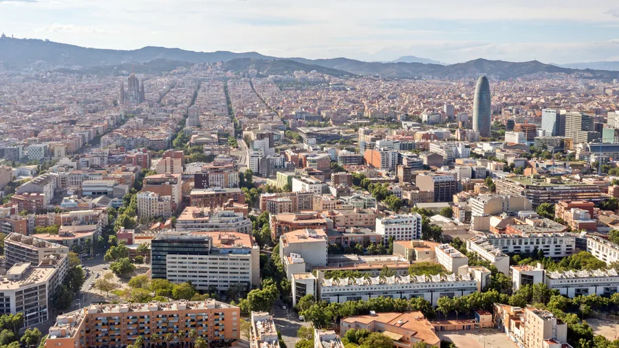
Collserola Natural Park covers 8,295 hectares of the mountain range that separates Barcelona from the Vallès plain, spread across nine municipalities including Barcelona, Cerdanyola del Vallès and Sant Cugat del Vallès. The sierra was placed under a special protection plan in 1987, and in 2010 the Generalitat de Catalunya granted it Natural Park status. With the Tibidabo summit reaching 512 metres, the park is part of the Natura 2000 Network and receives close to two million visitors per year, making it one of the most frequented peri-urban green spaces in Europe. The 3.5 million people living in the surrounding municipalities have direct access to a continuous forest area without long travel.

The dominant landscape is Mediterranean forest of Aleppo pine and holm oak, covering the north-facing slopes with dense greenery that carries the scent of warm resin by mid-morning. Valley floors and seasonal streams host poplar and elm groves, while the sunnier hillsides sustain scrubland with rosemary, heather and lentisk. The variety of habitats follows an altitudinal gradient from 60 to 512 metres and the sierra's dual orientation: the drier south face receives direct marine influence from the Mediterranean, while the wetter north face connects to the continental climate of the Vallès. Abandoned fruit trees and old vineyard remnants in forest clearings document centuries of farming.

The Carretera de les Aigües is the park's best-known route: a flat 9-kilometre path following the 300-metre contour on the Barcelona side. Originally built to service the city's water channels, it now offers open views over Barcelona, the harbour and the sea with almost no elevation change. It is the busiest trail in the park for runners, cyclists and families with children. Other notable routes include the climb to Tibidabo from Vallvidrera (4.5 km, 250 m elevation gain), the circular Font Groga loop (3 km, suitable for all ages) and the full sierra traverse on the GR-92, which crosses the park from north to south in about 5 hours.

The park's fauna includes over 130 documented bird species. Sparrowhawks, common buzzards and tawny owls are regular residents of the canopy. On the ground, wild boar and foxes are the most visible mammals; the common genet, being nocturnal, is spotted less frequently. The streams support populations of marbled newts and common frogs. In forest clearings during spring mornings, robins, goldfinches and blackbirds gather in the low shrubs. Managing the wild boar population is one of the park consortium's ongoing tasks, as these animals frequently interact with Barcelona's peripheral neighbourhoods.

The park functions as a daily-use green corridor for residents of the Barcelona metropolitan area. The trail network links neighbourhoods such as Vallvidrera, Les Planes and La Floresta to the park interior, allowing access on foot from the city without a vehicle. The Can Coll Information Centre in Cerdanyola del Vallès and the Can Balasc Environmental Education Centre run guided activities and nature workshops year-round. Hermitages like Sant Medir, Santa Creu d'Olorde and Sant Iscle de les Feixes mark the routes with historical references dating to the 10th and 11th centuries. The Can Coll farmhouse, restored as an interpretation centre, maintains a teaching garden and a collection of local crop varieties that illustrate the historical relationship between the sierra and the rural community that once inhabited it.

Practical information

Everything you need to know for your visit to Collserola Natural Park

How to get there
From Barcelona, FGC trains (S1/S2 lines) reach Baixador de Vallvidrera station in about 20 minutes from Plaça Catalunya. By car, the BV-1462 from Sant Cugat or the BP-1417 from Vallvidrera provide access to the main car parks. Bus lines 111 and V3 connect upper Barcelona with the park.
Area Information
Can Coll Information Centre (Cerdanyola del Vallès) offers exhibitions and guided activities. Can Balasc Environmental Education Centre runs workshops. Picnic areas at Can Coll, Santa Creu d'Olorde and Font de la Budellera. Dining available in Vallvidrera, Les Planes and La Floresta.
Geography
NE–SW coastal sierra between the Vallès plain to the north and Barcelona to the south. Highest point at Tibidabo (512 m). Composed of Palaeozoic slates and limestone, with seasonal streams draining towards the Besòs and Llobregat rivers.
Flora & Fauna
Aleppo pine and holm oak forest with rosemary, heather and lentisk understorey. Poplar and elm groves along streams. Fauna: wild boar, fox, common genet, squirrel. Birds: sparrowhawk, buzzard, tawny owl, robin, goldfinch, blackbird. Amphibians: marbled newt and common frog in the streams.

Things to do

Find the best plans and things to do in Collserola Natural Park

20

Accommodations

Best accommodation options in Collserola Natural Park

Loading accommodation options...

Frequently Asked Questions

Get answers about Collserola Natural Park

Yes. FGC trains (S1 and S2 lines) reach Baixador de Vallvidrera in about 20 minutes from Plaça Catalunya. Bus lines 111 and V3 also connect upper Barcelona with park entrances. Once inside, the trail network allows you to get around without a car.
The Carretera de les Aigües runs about 9 kilometres along the 300-metre contour on the Barcelona side of the sierra. It is virtually flat with no significant elevation change, suitable for people of any fitness level. It is very popular with runners, cyclists and families with young children, offering open views over Barcelona and the sea.
Wild boar are common in Collserola, particularly at dawn and dusk. They are not usually aggressive unless they feel cornered. It is advisable not to feed them, to keep your distance and to keep dogs on a lead at all times. The park consortium manages the population through regular censuses and control measures.
Yes, but with restrictions. Cycling is permitted on wide paths, forest tracks and the Carretera de les Aigües, but not on narrow trails marked as pedestrian-only. In summer, fire-risk restrictions may limit access to some areas. Check the park website before planning your route.
The park offers several family-friendly options: the Carretera de les Aigües is flat and pushchair-accessible, the Can Coll Information Centre runs nature workshops for children, and the picnic areas at Santa Creu d'Olorde and Font de la Budellera have tables and drinking fountains. In spring, guided birdwatching visits are suitable for children aged 6 and above.