Why Spain Stands Out for Canyoning
Spain concentrates short mountain ranges, limestone massifs, and Mediterranean gorges that make canyoning varied and reliable across seasons. If you know barranquismo Sierra de Guara, you already recognize how Guara’s sculpted canyons set the benchmark for style, access, and safety culture. From Aragón to Andalusia and the Picos de Europa, the country offers beginner-friendly aquatic routes and big-wall abseils for experts.
You will find here how we selected the highlights, what each destination demands, and when to go. Picture cool water threading through pale stone as swifts cut the sky overhead. Use the destination sheets, the interactive map, and the practical tips to reserve responsibly with certified guides and to match the route to your level.
Canyoning in Spain: tradition, hotspots, and seasons
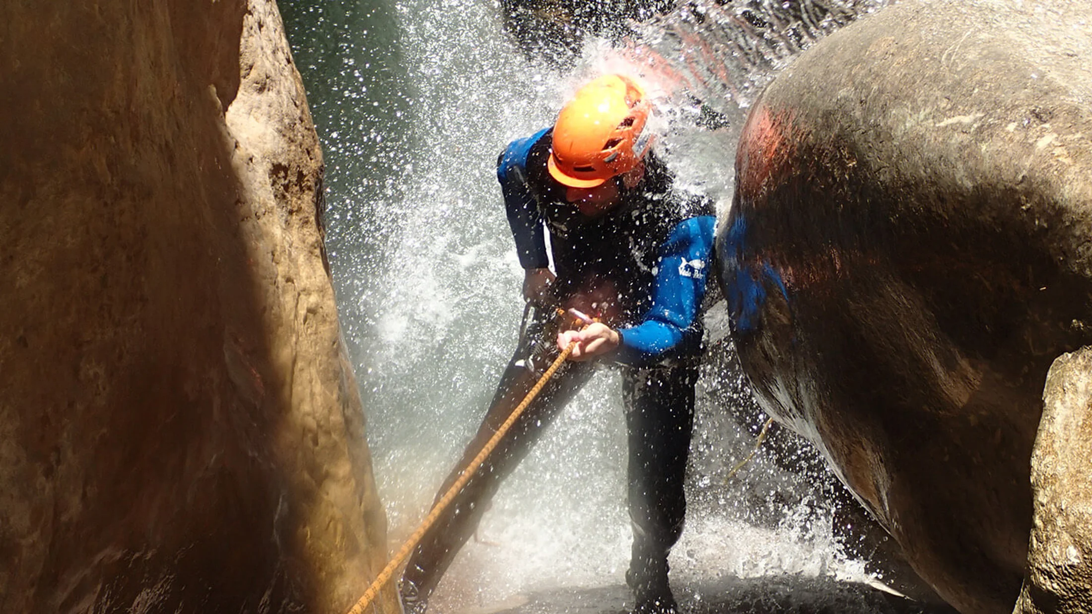
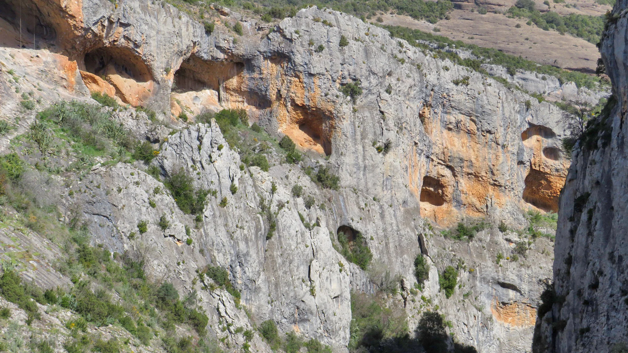
Spain’s canyoning tradition grew around limestone and conglomerate massifs where water carves narrow corridors and jumps form natural steps. The Sierra y Cañones de Guara in Huesca became a national reference thanks to early exploration, easy logistics from Rodellar and Alquézar, and a safety‑first guide culture (Gobierno de Aragón, Parque Natural, management plans). Sun warms the canyon rims while water stays mountain-cool even in summer.
Hotspots cluster in Aragón (Guara), Andalusia (Río Verde near Otívar and Garganta Verde in Grazalema), Cantabria/Asturias (La Hermida gateways into Picos de Europa), and Granada’s Sierra Nevada. Seasonality varies: spring to early autumn is typical, but storms can spike flows, and some parks impose summer or nesting‑season restrictions. Local guides and rangers balance access with wildlife protection; your reservation supports both safety and conservation.
How we selected the canyons featured
We prioritized a clear spread of difficulty, scenic quality, and access so couples, families, and expert groups all find a good fit. We checked logistics (parking, approach, return), availability of certified guides, incident history, and typical flow patterns. Salt on the lips after a clean jump reminds you why water conditions matter.
- Difficulty and skills required: from aquatic hikes to technical multi‑rappel descents.
- Landscape aesthetics: sculpted narrows, emerald pools, and viewpoints.
- Access and transport: approach time, shuttle options, and parking rules.
- Guide availability: local, certified companies with safety records.
- Safety record: rescue access and incident patterns.
- Permits and park rules: quotas, closures, and conservation.
- Best season: typical window, flow sensitivity, and heat/cold exposure.
We balanced classic beginner routes with iconic expert lines so you can progress sustainably.
Picuco te puede ayudar
Does something here catch your eye?
Tell us.
Write to us on WhatsApp or email: we answer questions, find the best options and help you sort out the booking.
How To Choose a Canyon Safely and Well
Start with a frank assessment of your group’s skills, fitness, and comfort with cold water, heights, and swims. In canyoning, difficulty blends technical moves (abseils, jumps, downclimbs), hydraulics (flow strength, siphons), and commitment (remoteness and escape options). In dry heat, wet neoprene against your forearms feels like shade on the skin.
Think in three bands: easy, intermediate, and difficult. Easy often means short abseils under 10–12 m, optional jumps, and clear exits; intermediate adds longer abseils (15–25 m), mandatory swims, and narrow hydraulics; difficult may include multi‑pitch abseils over 30 m, siphons or technical anchors, and long approaches. Always confirm if jumps are mandatory; many famous jumps have safe alternatives on a rope.
Use objective risk indicators:
- Flow and forecast: sudden storms turn narrow slots into hydraulically powerful chutes; check regional rain radar the previous 48 hours and on the day.
- Key technical passages: the tallest abseil, a siphon, or a committed narrows section; know exact heights and whether a guided handline is used.
- Pool depth: summer drought can shrink pools; guides re‑evaluate jump spots daily.
- Escape options: note mid‑canyon exits and mark them on your topo.
- Temperature: cold water saps energy fast; choose thicker neoprene if water is snowmelt‑fed.
Permits and rules matter as much as ropes. Some descents, like Garganta Verde and Río Verde, require advance permits or reservations managed by the park authority; companies often secure them for clients. Insurance should cover adventure sports and rescue costs; certified guides typically include civil liability and accident cover for clients—ask for policy details. Reading recent route reports helps you interpret conditions: a “pushy 3” flow rating or “anchors re‑equipped 2023” condenses real-world intel.
Match your level to the route:
- First‑timers or families with teens: choose aquatic, low‑commitment canyons with short abseils and strong guide presence.
- Fit intermediates: add one or two longer abseils and a half‑day approach.
- Experts: pick big‑wall abseils and narrow hydraulics—only with weather windows and full kit redundancy.
For example, Mascún in Sierra de Guara becomes significantly more technical after heavy rain because narrow sections amplify hydraulics and safe jump lines shift. The echo of water thudding into a pothole is a cue to pause, reassess, and maybe switch to a guided abseil instead of a jump.
Practical tip
Carry a printed topo in a zip bag and download an offline map; mark escape points and anchor locations with waypoints before you leave phone coverage.
Spain’s Top Canyons at a Glance
Before diving into each sheet, use this quick comparison to shortlist by level, season, and logistics. Sunlight skims green pools like glass laid over limestone.
| Canyon | Region | Typical difficulty | Duration | Permit required | Ideal for |
|---|---|---|---|---|---|
| Mascún (Sierra de Guara) | Aragón | Intermediate–Difficult (variants) | 6–10 h | Park rules; seasonal restrictions possible | Experienced groups with a guide |
| Río Vero (Sierra de Guara) | Aragón | Easy–Intermediate | 4–6 h | Usually no; check local regs | First‑timers, families with teens |
| Río Verde (Otívar/Nerja) | Andalusia | Easy–Intermediate–Advanced sections | 4–7 h | Yes (park permit/booking) | Mixed groups on Costa del Sol |
| Garganta Verde (Grazalema) | Andalusia | Intermediate–Difficult | 4–6 h | Yes (strict quotas/seasons) | Fit intermediates with guide |
| La Hermida area (Picos) | Cantabria/Asturias | Intermediate | 3–6 h | Generally no; check zones | Active travelers in the north |
| Cahorros de Monachil | Granada | Easy–Intermediate | 3–4 h | No in most cases | Beginners near Granada |
Mascún, Sierra De Guara: The Icon That Shaped a Sport
- Location: Rodellar and Alquézar, Huesca (
42.291°N, 0.075°W). - Why it’s iconic: varied narrows, sculpted limestone, historic descents that defined canyoning in Spain.
- Variants: Mascún Superior (more technical) and Lower Mascún.
Mascún epitomizes canyoning Sierra de Guara: a full‑value descent mixing long approaches, photogenic slots, and decision‑making under changing flows. The cool breath of the canyon rises from turquoise potholes as bearded vultures circle above. Expect key abseils around 15–25 m, optional jumps that guides re‑evaluate daily, and tight corridors where water concentrates.
- Difficulty: Intermediate to difficult depending on variant and flow.
- Duration and length: 6–10 hours total including approach and return; plan for a full day.
- Access and parking: Park near Rodellar and hike to the start; return via marked paths; vehicle access is limited within the park.
- Best season: Late spring through early autumn, avoiding storm days; shoulder seasons can be cold in the water.
- Permits and rules: Within Parque Natural de la Sierra y Cañones de Guara; seasonal wildlife restrictions can apply—check updates from the park authority (Gobierno de Aragón). Guided companies manage compliance.
- Guide need: Strongly recommended unless you have advanced skills and local knowledge.
- Indicative guided price: 65–110 € per person depending on group size, season, and variant; includes gear in most cases.
- Gear tips: 5 mm two‑piece wetsuit, helmet, canyoning harness, descender, 30–40 m rope plus pull line, dry snacks, and warm layer for the approach.
- Stay nearby: Rodellar and Alquézar offer small guesthouses and rural stays that live year‑round with the ebb of visiting climbers and canyoners.
Conservation and safety
Stay on established approaches to reduce erosion, respect seasonal closures for nesting raptors, and pack out all waste. After storms, hydraulics in Mascún rise fast—cancel rather than gamble.
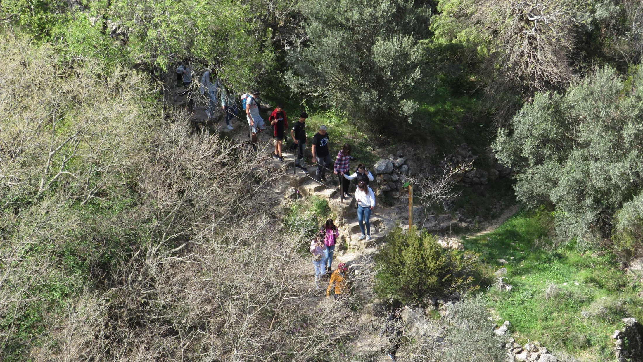
Río Vero, Sierra De Guara: The Classic Aquatic Traverse
- Location: Alquézar, Huesca (
42.170°N, 0.028°W). - Profile: Aesthetic, mostly aquatic traverse with manageable obstacles—ideal for strong beginners and intermediates.
Río Vero blends canyoning with river trekking through grand galleries of honeyed limestone and prehistoric rock‑shelter landscapes (Cultura del Río Vero). Water murmurs over pebbles while swallows stitch the air above broad light wells. Expect swims, small jumps (always checked by the guide), and shorter abseils or handlines depending on chosen sections.
- Difficulty: Easy to intermediate depending on segment.
- Duration: 4–6 hours; shorter family‑friendly sections exist.
- Access: Trailheads around Alquézar; shuttles or staged vehicles make logistics smoother in peak season.
- Best season: Late spring to early autumn; flows can be low by late summer—guides adapt route choice.
- Permits: Generally no formal permit for standard sections, but parking and access regulations change in summer; consult the park office.
- Guides and prices: Numerous local companies in Alquézar and Barbastro; typical guided outings 50–80 € pp with gear.
- For whom: Families with teens, first‑timers, and travelers seeking scenery over big abseils.
- Stay nearby: Alquézar’s stone alleys and small inns keep close ties to the canyon, with cafés that open early for big days out.
Tip: In drought summers, pool depths drop and some jumps become abseils; a guide’s daily reconnaissance keeps things smooth.
Río Verde (otívar/nerja): Emerald Pools on the Costa Tropical
- Location: Sierra de Tejeda, Almijara y Alhama Natural Park, municipality of Otívar, near Nerja and Almuñécar (
36.812°N, -3.677°W). - What makes it special: Clear emerald pools, polished slides, and easy access from the Costa del Sol.
Barranquismo Río Verde is the reference for canyoning near Nerja and along the eastern Costa del Sol. Sunlight flickers on travertine edges before you slip into glassy pools. The standard section suits beginners and mixed groups, while the upper section adds longer abseils and a wilder ambiance for experienced intermediates.
- Difficulty: Easy to intermediate on the standard route; advanced variants upstream.
- Duration: 4–7 hours depending on section and shuttle.
- Access and logistics: Parking controls apply on busy weekends; many operators include transfers from Nerja or Almuñécar.
- Best months: April–October, avoiding stormy days; summer water is refreshing but wear full neoprene.
- Permit and quotas: Mandatory advance booking/permit system managed by the Andalusian authorities for daily quotas; companies usually arrange it.
- Guides and prices: Numerous certified providers in Nerja, Frigiliana, and Almuñécar; expect 55–95 € pp with gear and transfers in season.
- For whom: Couples and families on the coast, or travelers seeking a memorable day away from the beach.
- Stay nearby: Rural stays in Frigiliana’s whitewashed hills or apartments in Nerja balance sea breezes with mountain quiet.
Barranquismo Málaga practical note
Río Verde anchors canyoning in Andalusia’s coastal corridor. If parking lots fill, guided trips with early starts beat the crowds and simplify permits.
Garganta Verde (zahara De La Sierra): A Dramatic Limestone Chasm
- Location: Sierra de Grazalema Natural Park, near Zahara de la Sierra (
36.844°N, -5.391°W). - Landscape character: Towering vertical walls, sculpted narrows, and lush riparian pockets that shelter birds of prey.
Garganta Verde’s tall, shadowed walls concentrate the senses and demand calm movement through polished rock. The air smells faintly of damp moss as light pours down like a narrow beam. Expect abseils in the 10–20 m range, sustained narrows, swims, and careful footwork on slick rock.
- Difficulty: Intermediate to difficult depending on water level and chosen passages.
- Duration: 4–6 hours; commitment increases in the heart of the narrows.
- Access: Approach from parking areas signed from Zahara; returns vary by chosen exit.
- Season and weather: Strict seasonal windows aim to protect wildlife and manage risk; avoid or postpone after rains.
- Permits and regulation: Mandatory permit with strict daily quotas; some periods restrict descent to guided groups—confirm with the park office (Junta de Andalucía, Sierra de Grazalema).
- Guides and prices: Local companies around Grazalema, Zahara, and El Bosque; typical guided rates 60–100 € pp including gear.
- For whom: Fit intermediates seeking a powerful visual setting and a structured, guided descent.
- Stay nearby: Zahara’s hilltop views and family‑run inns root the experience in the pueblos’ cadence of evening plazas and slow meals.
Regulation reminder
Garganta Verde is among Andalusia’s most regulated descents. Secure permits well ahead, carry ID, and be ready to show your reservation at checkpoints.
La Hermida Area, Picos De Europa: Northern Narrows and Mountain Light
- Location: Desfiladero de La Hermida corridor, Cantabria/Asturias (
43.237°N, -4.611°W). - Character: Steep green mountains, narrow valleys, and canyons like Navedo or Rubó that channel crisp Atlantic air.
When people say canyoning Picos de Europa, they often start around La Hermida, where roadside gorges hide elegant abseils minutes from mountain inns. Cowbells carry from high meadows as water flashes silver through beech shade. Expect intermediate profiles: abseils up to roughly 20–25 m, slides, and jumps adjusted to daily flows.
- Difficulty: Typically intermediate; route choice tailors to group level.
- Duration: 3–6 hours depending on canyon (e.g., Navedo for compact fun, Rubó or Cicera for longer outings).
- Access and parking: Trailheads close to the
N-621; plan early arrivals on summer weekends. - Season and flows: Late spring through early autumn; Atlantic storms raise flows quickly—guides adapt timings to avoid spikes.
- Permits: Generally none for standard descents, but always confirm local rules and temporary closures.
- Guides and prices: Providers in Potes, La Hermida, and Arenas de Cabrales; 50–85 € pp with gear is common.
- For whom: Active travelers touring the north and families with teens ready for real abseils.
- Stay nearby: Rural hotels with chestnut beams and hearty stews turn a canyon day into a mini‑break.
Note: Public transport is limited; a car or guide‑provided transfers simplify logistics across the valley.
Cahorros De Monachil (sierra Nevada): Adventure Minutes from Granada
- Location: Monachil, 8–12 km from Granada center (
37.133°N, -3.555°W). - Why it’s popular: Quick access, photogenic hanging bridges, and friendly abseils close to the city.
Cahorros marries a scenic hike with accessible canyon moves in a compact setting perfect for first experiences. The smell of thyme rides warm air off the sunlit slopes above the shaded river. Expect short abseils, optional jumps assessed by your guide, and playful squeezes beneath overhangs.
- Difficulty: Easy to intermediate depending on chosen section and water.
- Duration: 3–4 hours for most guided circuits.
- Access: Parking areas at Monachil; short approaches lead to the Cahorros path and canyon entries.
- Best season: Spring and early autumn; avoid or postpone after heavy rain when flow rises.
- Permits: Not typically required; local rules or closures may apply in the broader Sierra Nevada protected area—check before you go.
- Guides and prices: Several Granada‑based providers; 40–75 € pp with gear for introductory descents.
- For whom: Beginners, families, and city‑break travelers wanting an adventurous half day.
- Stay nearby: Combine with a night in Granada’s neighborhoods or choose a countryside casa rural in the foothills.
Tip: Arrive early on weekends; the hiking path sees traffic, and early starts give you quieter pools and bridges.
Interactive Map: Find, Filter, and Plan Your Descent
Our interactive map places each canyon pin with its difficulty band, best season, and practical notes on access and parking. The map also tags where local providers are based, helping you plan transfers and post‑canyon meals. Cool blue icons trace rivers across pale terrain like a hand‑drawn sketch.
Use filters to:
- Select by level (easy, intermediate, difficult) to match your group.
- Filter by distance from cities (Granada, Málaga, Huesca, Santander) for short breaks.
- Toggle best season to see spring‑only or summer‑safe options.
Planning tips:
- Click a canyon pin to see approach notes, estimated duration, and if a permit is required.
- Save a custom layer with your chosen routes and accommodations.
- Export the map for offline use or embed it into your trip plan as a
KML/GPXdownload.
Open the map on Picuco to build an itinerary and pick nearby rural stays with morning check‑ins that suit early guide rendezvous. Print the map view with coordinates and share it with your guide so everyone aligns on access and exit points.
Practical Tips: Routes, Guides, and Gear You Really Need
Choosing a provider:
- Certifications: Look for Spanish/European certifications (e.g., TD2/TD3 for canyoning leaders) and current first‑aid training.
- Ratios and group size: Safer, smoother days keep ratios around 1–1; ask for the maximum participants per guide.
- Reviews and recent photos: Scan for mentions of anchor maintenance, decision‑making on jumps, and pace management.
- Insurance: Confirm civil liability and personal accident coverage; ask for policy scope and emergency procedures.
Essential gear list (guided trips usually include most items):
- 5 mm wetsuit (two‑piece in colder canyons), neoprene socks, grippy canyon shoes.
- Helmet, canyoning harness, descender, cow’s tails, and quick‑links.
- Rope length matched to the tallest abseil, plus
tag linefor pulls. - Waterproof snack stash, 1–1.5 L water per person, compact thermal layer for stops.
- Small first‑aid kit, whistle, and
headlampfor late exits.
Transport and parking:
- Book early‑morning starts to secure spots at small trailheads.
- Use provider shuttles for linear descents (e.g., Río Vero traverses, Río Verde variants).
- Bring coins or apps for rural parking meters where applicable.
Questions to ask when reserving:
- Max group size, backup plan if flows rise, and whether jumps are optional.
- Permit handling, cancellation terms for weather/flow, and exact meeting point time.
- Clothing needed under the wetsuit and seasonal water temperature estimates.
Combine canyoning with rural stays and activities:
- Sierra de Guara: add a sunset stroll in Alquézar and a morning hike to cave art sites.
- Andalusia (canyoning Andalusia): pair Río Verde with Frigiliana’s trails or Grazalema’s karst peaks after Garganta Verde.
- Picos de Europa: alternate canyon days with short ridge walks and cheese tasting in Liébana valleys.
Families: choose easy/intermediate routes, confirm minimum ages (often 10–12 years), and ask for extra neoprene layers. Technical seekers: request advanced sections, longer abseils, or courses on rigging and anchor evaluation. A day that starts with careful questions usually ends with relaxed smiles at the trailhead bar.
Frequently Asked Questions
Do I need previous experience?
No for easy and some intermediate canyons if you go with a certified guide; you will learn abseil basics on site. If heights or cold water worry you, start with Río Vero, Río Verde standard, or Cahorros. Move to Mascún or La Hermida’s longer abseils once you’re comfortable.
When are descents cancelled for flow or rain?
Guides cancel when rain raises flows or forecasts show storm cells crossing the watershed. Narrow slots magnify hydraulics even after short rain bursts. Check the practical tips section for how to read forecasts and always accept guide calls to postpone.
Are permits or advance reservations required?
Some canyons have strict controls. Río Verde and Garganta Verde require advance permits/quotas, sometimes restricted to guided parties in certain seasons. Sierra de Guara may enact seasonal wildlife closures—confirm with the park office. Providers typically manage permits for clients.
What insurance is recommended?
Ensure adventure‑sports and rescue coverage; guided trips usually include civil liability and accident insurance. Independent parties should confirm rescue costs in the region and carry proof of coverage.
Can I bring a phone or camera?
Yes, in a waterproof pouch and lanyard; better yet, a compact action camera on a leash. Keep hands free for downclimbs and abseils, and never jump with a loose device.
How do I choose between guided and self‑guided?
Go guided if you are new, visiting a regulated canyon, or facing uncertain flows. Self‑guiding suits experienced teams who know anchors, rescue techniques, and local escape routes. Our selection and tips outline when guides add safety and make logistics easy.
Ready to Plan Your Descent?
Spain’s compact mountains, clear pools, and sculpted limestone make progress natural, from first splash to confident multi‑rappel days. The scent of pine on a warm approach gives way to cool canyon shade, a rhythm that keeps you returning. Choose a route that matches your skills, time your day for weather and flow, and respect each park’s rules.
Open Picuco’s interactive map to shortlist canyons by level and season, then reserve a date with a certified local guide and pick a nearby rural stay for an unhurried morning. If your dates are flexible, ask providers which routes are in prime condition the week you arrive. Above all, tread lightly—stay on approaches, leave anchors as you found them, and keep these canyons thriving for the communities and wildlife that share them.