Why the Zumaia Flysch will surprise you
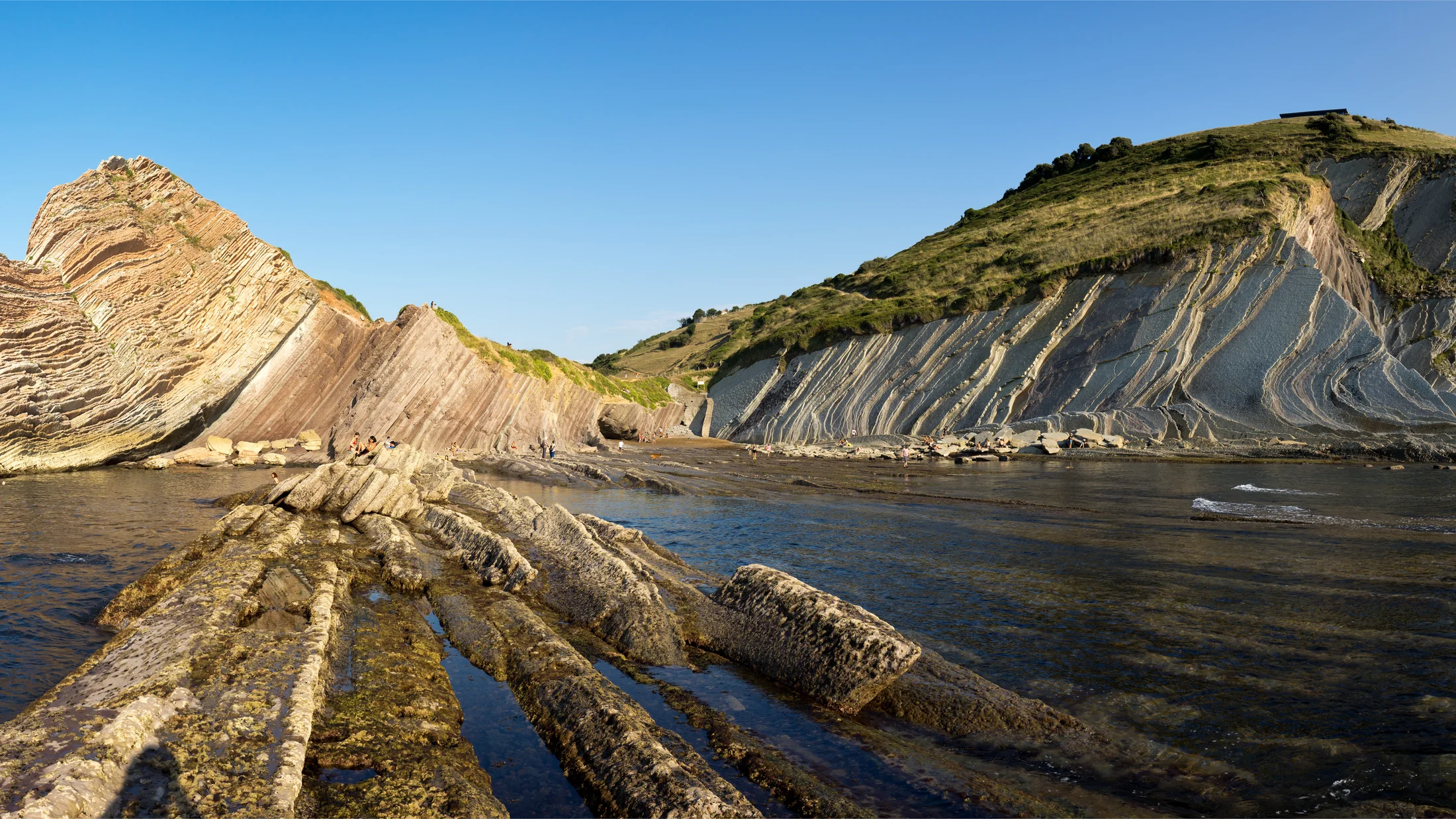
The Zumaia Flysch is one of those places that changes your sense of time scale in a single walk. Here, the rock layers can be read like the pages of a book telling 60 million years of history, which is why it is a magnet for hikers, curious families and lovers of photography. When you walk down to Itzurun and look at the striated cliffs, the roar of the Cantabrian Sea seems to set the rhythm for an outdoor geology lesson. We tell you how to get there, when to go, which routes to take and how to experience it safely.
This stretch is part of the Basque Coast Geopark, a territory recognised by UNESCO for its geological and educational value, covering Zumaia, Deba and Mutriku. The Cretaceous–Paleogene (K–Pg) boundary is preserved in its cliffs, the famous "chapter" that marks the extinction of the dinosaurs about 66 million years ago. Imagine a stone knife blade that the sea polishes without rest, and you will have the image of this flysch. If you like walking at your own pace, there are itineraries for everyone: from the short circular Itzurun route, 1.52 km, to the great coastal trek towards Deba or Mutriku.
The Flysch route is not just science: it is also maritime culture, viewpoints, hermitages like San Telmo and wild beaches like Sakoneta. The smell of saltpeter and fern mixes with the voices of fishermen and families strolling at dusk. Bring footwear with good soles, check the tides and decide whether you prefer the perspective from land or from a boat trip. In the following sections, you will find how to plan your visit in detail and tips to get the most out of it without risks.
Picuco can help you
Does something here catch your eye?
Tell us.
Write to us on WhatsApp or email: we answer questions, find the best options and help you sort out the booking.
Write to us
We guide you based on the type of plan you have in mind and reply by WhatsApp or email.
What is flysch and why Zumaia is key for science
Flysch consists of hard layers of sandstone and limestone alternating with soft layers of shale and marl, deposited in ancient deep seabeds. Those sheets of different hardness were stacked in order, and sea erosion carves them like the leaves of an open book. That contrast explains the parallel grooves carved by the waves.
Zumaia is a world reference because its stratigraphic series is almost continuous and very well exposed. Here, the Cretaceous–Paleogene (K–Pg) boundary outcrops, marked by a thin layer of clay rich in iridium, an element associated with the impact of a large meteorite 66 million years ago. For geologists and teachers, the place functions as a first-rate natural classroom.
The flysch is part of a coastal system where tectonics lifted ancient marine sediments and the waves sculpt them today. The Geopark also has one of the largest tidal flats in Europe.
If you travel with children or students, it is a good opportunity to see concepts such as "strata", "mass extinction" or "orbital cycles" with real examples right in front of you.
To see it from the water, the boat trip departs from Txomin Agirre Pier, in Zumaia, lasts 1 hour and costs 19.00 € (under 12 years old: 11.00 €). Capacity is limited to 39 visitors per trip and the departure depends on the state of the sea for safety reasons, so book in advance and confirm the day before.
The essentials for planning your visit
Location and map: Itzurun, Zumaia and the Basque Coast Geopark
Itzurun beach, in Zumaia, is the clearest starting point to see the flysch. It is on the coast of Gipuzkoa, between Donostia–San Sebastián and Bilbao, within the Basque Coast Geopark, which covers Zumaia, Deba and Mutriku.
Itzurun is an accessible beach, with heavy swell and wind on many days.
Above the beach and a flysch cliff is the San Telmo hermitage, dedicated to the patron saint of sailors, with an upper viewpoint. The Zumaia marina, with boat trips and cafés, is another useful landmark.
The Geopark is a continuous coastline between Zumaia, Deba and Mutriku, with marked inland sections to connect viewpoints. To orient yourself, download the GR-121 route (Talaia Ibilbidea) on your mobile and mark Itzurun as the first waypoint; plan alternative escape routes towards the road in case of bad weather.
You reach the beach in 1 km from the Euskotren stop and the Lurraldebus UK01 stop, and the nearest road is the N-634. Seagulls trace circles above the crests of the waves.
Best time, tides and schedule: safety and planning
The Zumaia Flysch can be visited all year round, but spring and autumn offer the best conditions: mild temperatures of 12–22 °C, fewer people and good light. In summer there are more hours of sunlight and more visitors. In winter, storms intensify the swell and can cause occasional access closures.
The tide rules. At low tide, the intertidal platforms are exposed; at high tide, the sea covers the pathways. This decides safe access to the base of the cliffs and also the photo: textures at low tide, waves breaking at high tide.
Before heading out, check the tide tables by reference port on Puertos del Estado and the local swell and wind forecast on Euskalmet. Note the time of low tide and high tide and add a safety margin of 60–90 minutes.
Avoid the rising tide in the late afternoon if you are far from an exit, and avoid spring tide days with heavy swell. If you are in doubt, choose high viewpoints and routes along the upper part.
How to get there by train, car and bus from San Sebastián
Zumaia is less than an hour from San Sebastián, and the train leaves you a flat walk away from the flysch. Choose your transport according to what you want to do when you arrive.
The station is an 8 min walk from Santiago Beach and 12 min from the Itzurun Flysch, via a flat walk through the centre.
The bus also connects Donostia and Zumaia in 40–60 min depending on the intermediate stops. It departs from the Donostia Bus Station and stops in Zumaia; on the bus, you can use BAT, Barik or Mugi cards.
If you go by car, in summer parking near Itzurun is limited and regulated. Use the car parks in the centre and walk 10–15 minutes to the coast.
For the Flysch route, start in Zumaia (car park or Euskotren station) and return from Deba by Euskotren train. The route follows the GR-121 path, with white and red markings.
Leave early to avoid peak hours and to have a margin with the tides. Carry your tickets loaded on the app or on your card to avoid queues.
Where to sleep and eat in Zumaia and surroundings
Sleeping in Zumaia allows you to head out at sunrise with low tide if you make the trek to Deba or Mutriku. There are hotels and hostels in the old town, tourist apartments and agrotourism stays on the outskirts.
Choose according to what you are looking for. In the centre of Zumaia, you have Itzurun and the port within walking distance. The rural surroundings between Zumaia and Deba offer more tranquillity and it is easier to park. Deba or Mutriku are suitable if you are doing a long linear route and prefer to sleep at the end.
In high season, book 2–4 weeks in advance, especially for weekends. Check updated prices and confirm the cancellation conditions before booking.
To eat, look for seafood cuisine with fish of the day and marmitako, and grills near the port. In the streets of the old town, there are pintxos and cider houses. If you are going in a group, ask for set menus and timings outside of peak hours.
If you bring food, have a responsible picnic at the viewpoints: avoid fragile areas and take your waste back with you.
The Flysch route on foot
1. Itzurun short route (Circular): ideal for families and photography
It is suitable for families and for those going with a camera: you walk little and see a lot.
The San Telmo hermitage is located above Itzurun beach. If the tide allows, the return journey includes a walk on the sand.
Start at the San Telmo hermitage: from Zumaia, it is enough to follow the signs there. In Algorri cove, a black layer from 66 Ma appears, which helps explain the extinction of the dinosaurs.
It is advisable to go with low or mid tide to see more of the platform and backlighting, and do not go down to the foot of the cliff at high tide. Wear footwear with grippy soles. For photography, the golden light arrives early in the morning or at sunset. On weekends, arrive early to park and explore Itzurun calmly.
The fizzing of the foam against the base of the cliff sounds like a constant background radio.
2. Zumaia–deba (Linear): classic route and how to organise return transport
The Zumaia–Deba trek is the classic of the Flysch route: 13–14 km and 5–6 hours depending on stops, with a cumulative elevation gain of ~600–700 m. The route alternates between hillside paths, passes through meadows and descents to coastal stretches if the tide allows.
Follow the GR-121 (Talaia) signage, with white and red markings and marked local diversions. The terrain mixes tracks, paths and meadows: there is mud with rain and exposed sections next to cliffs with railings. There are not many fountains, so carry 1.5–2 L of water and something salty.
To return to Zumaia from Deba, you have the train, with regular frequencies. Deba has an Euskotren station (line 1, Matiko–Amara) and a Lurraldebus stop outside the station.
- Euskotren towards San Sebastián: Monday to Friday from 05:50 to 20:50, every hour; Saturdays, Sundays and holidays from 06:50 to 20:50, every hour.
- Euskotren towards Bilbao: Monday to Friday from 06:43 to 20:43, every hour; Saturdays, Sundays and holidays from 08:43 to 21:43, every hour.
Check the schedules before leaving and include a margin for photographic stops. If you are travelling with two cars, leave one in Deba to gain flexibility.
3. Zumaia–Mutriku (Coastline): long route and variants for experienced hikers
Zumaia and Mutriku are connected by 17.7 km of coastline with continuous ups and downs: a demanding 6h 45' journey. It is the long route for hikers with experience and good fitness.
The route rewards the effort with natural balconies, solitary stretches and wild coves. As you cross the streams that fall into the sea in waterfalls, the smell of salt and damp earth mixes in the air.
At Algorri beach, one of the black layers could have witnessed the asteroid that ended the dinosaurs 66 million years ago. The arrival at Mutriku, a fishing village with a sheltered port, closes the stage.
If you want to shorten it, the classic Zumaia–Deba route is an option. From the marked high points, you can connect to local buses, so check the nearby stops before setting off.
Plan your water, food and departure with the first light to take advantage of the tides and soft light. Avoid unprotected edges with strong wind and do not go down to enclosed coves with the tide rising; detours to coves are only possible at low tide.
4. Low tide and formations route: geological itinerary to see layers and fossils
With the low tide, the Zumaia coastline reveals the strata and some fossils. This itinerary focuses on Itzurun–Algorri and/or Sakoneta, and is walked slowly, taking notes or photos.
Choose a 2–3 hour window around the lowest tide of the day. Check the Puertos del Estado tide tables and add 60–90 min of margin. Also check the swell on Euskalmet and the wind, and avoid high swell.
Use footwear with grippy soles or water shoes and keep your hands free to balance yourself. Keep your distance from the foot of the cliff due to rockfalls.
Notice the alternation of hard and soft layers, the ripple marks and the calcareous nodules. Fossils embedded in the strata, such as planktonic remains and traces, are not to be extracted. You can also see sliding structures and filled fractures.
Do not pick or take samples: photograph and leave everything as it is. If you have doubts, book a Flysch guided tour to interpret what you see: it departs from Muelle Txomin Agirre, in Zumaia, lasts 3 hours and costs 28.00 € (17.00 € for children under 12). The Flysch walking guided tour through Itzurun–Algorri is a short walk on the cliff to get to know the natural and geological heritage of the Geopark.
By boat, viewpoints and essential activities
1. Boat trips and guided excursions: advantages, bookings and recommendations
From the sea, the Flysch cliffs of Zumaia can be seen in their entirety and without obstacles, something you cannot achieve from above. The trips skirt the Zumaia–Deba stretch, within the Basque Coast Geopark, and approach points where the stratification appears like parallel blades. From the deck, the green of the meadows above contrasts with the grey bands of the rock and the blue of the water.
The boat has clear advantages: better angles to photograph continuous strata, a comfortable pace for families and mixed groups, and live geological interpretation by specialised guides. Excursions usually include clear geological explanations and examples pointed out from the deck.
On significant dates, it is advisable to book in advance to secure a spot and the best light schedule. Bring a lightweight raincoat and a camera cover, and choose a trip with low swell and mid tide to approach the coast safely.
2. Itzurun: essential beach, cliffs and viewpoints
Itzurun is the beach of Zumaia and the point where the flysch layers are seen most clearly. It is part of the Basque Coast Geopark and its sand has appeared in filming for shows like Game of Thrones.
You reach the beach via stairs and ramps. To take photos, go up to the San Telmo promontory, look for the vanishing lines that mark the layers, and wait for side lighting.
There are three spots that work well with a camera: the base of the cliff, only at low tide and with a safety distance; the balconies of the upper walkway with railings; and the natural steps of the intertidal platform. When the tide goes out, the platform turns into a shiny chessboard.
Before going down to the rock, check the tides. Avoid positioning yourself under unstable ledges and respect the signage and the areas closed due to landslides.
3. San Telmo Hermitage: history, access and views from the promontory
The San Telmo Hermitage overlooks the edge of the cliff, above the Zumaia flysch. It is dedicated to the patron saint of sailors and preserves local traditions linked to the sea and the protection of crews.
From the promontory, you can see the entire flysch strip and the coastline towards the west. The whitewashed hermitage against the grey slate of the cliff is the most recognisable image of the place.
Go at sunrise or sunset. In summer, avoid the middle hours due to overcrowding. You can combine the visit with the start of the route via the GR-121 towards Deba, and it is advisable to check the tide schedule to choose the direction of the walk.
With children, exercise extreme vigilance near the railings and do not cross marked-off areas: there is a risk of injury in case of falls.
By car, it is 35 km from San Sebastián (40 min) and 75 km from Bilbao (1 h). By train, Euskotren connects Bilbao, Zarautz, Zumaia and Donostia with regular frequency, and from the Zumaia station, you can reach the coast on foot in a few minutes. From Donostia, there are buses from lines UK09, UK10, UK11 and UK49G.
4. Elorriaga and other coastal viewpoints: less travelled routes
The Elorriaga viewpoints offer wide perspectives with fewer people than Itzurun and quieter walks. You can reach them via marked rural tracks from the local road, with sections of meadow and small groves.
To get to Artadi, follow the signs for route nº 4; to go from Elorriaga to Zumaia, follow those for route nº 3.
Here the flysch can be seen in profile, which helps to understand the inclination of the layers and their lateral continuity. The Zumaia–Deba route is marked with the GR-121 (Talaia).
If you are going to take photographs, bring wide-angle lenses to emphasise the lines of the layers and neutral density filters for the silk effect on the sea from safe high points. Check the weather before heading out: coastal mists can create unique atmospheres. Bring an offline map to identify entrances and exits via secondary tracks.
5. Sakoneta: wild beaches and rocky formations to explore
In Sakoneta, the flysch appears in its wildest version: a mosaic of fishbacks, rock pools and ridges that emerge at low tide. It is the best place to see the intertidal platform spread out like a stone carpet.
Access combines a path along the slope and a descent to the platform, so it requires attention and good footwear. Check the low tide and the swell before heading out, and avoid days with high swell.
Descend only with grippy soles and hands free, and do not approach the foot of the cliff. As the water recedes, the wet shine of the rock draws veins.
What to see: gentle folds, joints and surfaces polished by abrasion. In the rock pools there is intertidal life: observe it without disturbing or capturing it.
Set aside extra time to read the textures and photograph without rushing. If you are not used to moving over wet rock, stay at the high viewpoints: the view is still magnificent.
6. Highlighted activities: coastal hiking, photography, tide watching and geo-tourism
With one or two days in Zumaia, you can combine hiking, photography and geo-tourism without rushing. The key is to build your itinerary around the tides and the light.
To take photographs, choose sunrises and sunsets with low or medium tide and partially cloudy skies. Bring a lightweight tripod, ND filters and a waterproof cover.
Geo-tourism is done with accredited guides from the geopark, on foot or by boat; the boat trip depends on the state of the sea. The guided tour of the Flysch lasts 3 h 15 min, costs 22,00 € and has a minimum age of 12 years. It departs from the Zumaia tourist office and helps you recognise events such as the extinction of the dinosaurs or climate changes.
Bring footwear with grip, a windbreaker, 1.5–2 L of water and sun protection.
In summer, boat excursions and guided tours are in high demand: book 1–2 weeks in advance. At Picuco you can consult options grouped by activity and destination to compare schedules and levels.
Tips, safety and frequently asked questions
Safety and recommended equipment
Before setting off, check the weather forecast and the tides: the route changes with them. With those two pieces of data, you decide the schedule and the section you will do.
Footwear matters more than clothing. Bring boots or trainers with grippy soles, a windbreaker, a cap and sun protection. On 4–6 hour routes, calculate 1.5–2 L of water per person. If it rains, add a waterproof layer and poles for the mud.
On the cliffs, keep your distance from the edge, especially with wind. Avoid the foot of the cliffs due to rockfalls and do not position yourself under ledges. Regarding the tides, calculate wide margins and do not cross passages that close.
In autumn and winter, bring a headlamp if you are short on light. When with family, adapt the distances and choose high viewpoints. If you are in doubt, a guided tour provides safety and terrain reading.
Tides, permits and regulations (Responsible access)
The flysch is protected and fragile: walk without leaving a trace, without extracting rocks, fossils or organisms. There are sections with temporarily restricted access for safety or conservation, so respect closures, beacons and signage from the Basque Coast Geopark.
Before setting off, check the exact tide times at Puertos del Estado and the swell and wind at Euskalmet. Add a 60–90 min margin around low tide and avoid entering intertidal channels with the tide rising.
Walk along marked paths and do not cross closed meadows. Bring a bag for your rubbish and do not leave waste. If you go with a dog, keep it on a lead where indicated and pay attention to the intertidal fauna.
If you organise an educational activity, inform the participants of the conservation rules before setting off.
Accessibility and visits for people with reduced mobility
Before going, ask at the tourist office about ramps and temporary access enabled during the season. A recommended alternative is the accessible viewpoints marked in high areas, with nearby parking.
If you choose the boat trip, boarding is assisted in ports with staff and handrails. Confirm the conditions before booking.
Avoid steep walkways when it rains and plan for accessible toilets and rest times.
With group support and prior logistics, the experience can be just as intense and safe. Prioritise the views from above and, if possible, complement it with a boat trip.
What is the best time to visit the Zumaia Flysch?: synchronisation with tides
The best time depends on what you want to do in Zumaia. If you are looking to see the platforms and their textures, go at low tide. For photography, the golden light of sunrise or sunset works best. And if you want to avoid crowds, choose intermediate hours.
To observe the formations at the foot of the platform, arrive 60–90 minutes before low tide and leave when the tide starts to rise. For photography, aim for sunrise or sunset with low or medium tide. If you are doing a long hiking route, set off early: you will have soft light and time for unforeseen events. By boat, look for medium tide and calm seas to approach with stability.
The smell of salt is sharper in the calm of the early hours, when there is not yet a strong breeze.
Before setting off, check the tide tables at Puertos del Estado (nearby reference ports) and the forecast at Euskalmet. With spring tides and high swell, prioritise the viewpoints and avoid low-lying areas.
Can you see the flysch from a boat and on foot?: advantages of each option
Yes: the flysch can be seen on foot and from a boat, and the ideal thing to do is to combine both options if your plan allows it. Each one gives you a different reading of the same cliff.
On foot, you perceive the textures, the fine detail of the layers, and the sound of the sea as it polishes them. You gain geological detail, freedom of pace, and close-up photography, but you depend on the tides, physical effort, and the risks in low-lying areas.
From the boat, you understand the scale, the continuity, and the general shapes of the cliff. You have a complete panorama, comfort, and interpretive guidance, although you depend on the state of the sea and the departure schedule.
Choose according to your time, the state of the sea, and whether you are travelling with children or people with reduced mobility. During the season, book in advance and confirm the safety conditions before boarding.
Are there guided routes or educational activities available?: organised options
In the Costa Vasca Geopark, there are themed guided visits on foot and by boat, as well as educational workshops for schools and families. The guides explain in clear language what is seen and why, with examples visible on the cliff. You can choose between short introductory outings and longer interpretive routes.
The Flysch guided walk on foot through Itzurun–Algorri departs from the Zumaia Tourist Office. It costs 10,00 € (under 12 years old: 6,00 €). The boat excursion with geological explanation departs from the Txomin Agirre Pier, in Zumaia, and costs 19,00 € (under 12 years old: 11,00 €).
Capacity is limited to 39 visitors and there are audio guides in English, French, and German. The departure depends on the state of the sea.
On weekends and in summer, demand is high, so book in advance. An accredited guide multiplies what you learn per hour of visit and is the safest way to approach complex areas and understand them.
Can I look for fossils and take samples?: regulations and best practices
No. The extraction of fossils and rocks is prohibited in the protected areas of the flysch. The ethics of geotourism is to observe, photograph, and leave everything as it is so that others can also learn and enjoy.
Looking for fossils in situ with your eyes is fine: do not move or pull anything. You can take photos, sketches, and field notes, and see real pieces in interpretation centres and exhibitions. The right place to touch a piece is a museum or an authorised educational activity.
Avoid tools for extraction and do not enter cordoned-off areas or areas with a risk of landslides. If you are passionate about the subject, sign up for an outing with a paleontological focus: they will show you levels with remains and how they are read scientifically.
Book your experience — discover active tourism activities in Spain with local providers.
Conclusion and call to action: book, share and other recommended routes
The Zumaia Flysch brings together science, landscape and maritime culture in a stretch of coastline that is easy to explore with good planning. With the salty air and the low light, the pattern of the layers looks different every hour.
Book your excursions or accommodation in advance during high season, check the tides and choose routes suited to your level. To start, compare boat trips and interpretive visits and book your spot on the dates you want.
If you have an extra day, follow the coast towards Mutriku, within the Unesco Global Geopark on the Basque Coast, with a cumulative elevation gain/loss of +1080 / -1080 m.
When you return, try a new tide, different light and a different stretch: the flysch always tells something new. And share your experience and your photos to inspire others to visit responsibly.