Start Planning the Trans-pyrenean Gr-11
Why the Senda Pirenaica matters for your traverse
The GR-11, also called the Senda Pirenaica, crosses Spain’s Pyrenees from the Atlantic at Cabo Higuer to the Mediterranean at Cap de Creus. This end-to-end route threads through Basque coast, Navarrese beech woods, Aragon’s high granites, and Catalonia’s open valleys, offering a complete portrait of the range in one line. If you want to plan an ambitious traverse, choosing representative sections helps you manage time, logistics, and difficulty without losing the spirit of the whole. One gust off the ridge smells of lichen and distant thunder.
The trail’s modern layout follows the European GR system developed and maintained by regional federations and local councils, with waymarking standardized in Spain by FEDME (Federación Española de Deportes de Montaña y Escalada). While some walkers commit 35–50 days to the entire length, many prefer to combine iconic stretches that condense scenery, culture, and hut access. This article presents a selection that covers the GR-11’s essence and shows how to link stages, huts, and transport points into a smooth plan.
How we chose the must-walk sections
To curate the seven standout stretches below, we weighed access, huts and lodging, scenery, terrain variety, cultural interest, best time of year, and practical logistics. Access means reliable trailheads via road or public transport; huts include guarded (staffed with meals) and free shelters (unmanned, basic). The goal is to represent the GR-11’s diversity with options for weekend micro-traverses or multi-week blocks. Boots crunch over fir cones while mist lifts off a valley floor.
We also checked that each pick connects cleanly to adjacent etapas GR-11, so you can expand or shorten with minimal hassle. Finally, we favored areas where maps, signage, and seasonal services reduce uncertainty for self-guided trekkers. Use this list as a planning spine; then adapt pace and overnights to your experience and weather windows.
Picuco te puede ayudar
Does something here catch your eye?
Tell us.
Write to us on WhatsApp or email: we answer questions, find the best options and help you sort out the booking.
Quick Facts for the Senda Pirenaica
Essential numbers at a glance
- Total distance: roughly 820–840 km depending on variants and town detours. A sea breeze and pine sap mingle at dawn.
- Typical duration: 35–50 days for the full traverse; 6–9 hours walking per day is common on alpine sections.
- Cumulative ascent/descent: approximately 39,000–44,000 m of climb, with significant daily ups and downs in Aragon and central Catalonia.
- Average daily stage length: 15–25 km in most official
etapas GR-11, shorter in steep, rocky basins, longer in rolling eastern valleys. - Highest ambience: high-mountain sectors around Ordesa–Monte Perdido and Posets–Maladeta feature demanding passes and longer stretches above treeline.
These figures vary with detours to villages, weather alternatives, and the choice to combine or split stages. Confirm current distances on your GR-11 map and stage sheets before committing, because snow closures and hut openings can nudge you onto different lines.
Waymarking, trail types and difficulty
Across Spain, GR routes use white-red blazes on rocks, trees, and posts; X-shaped marks indicate wrong turns, and cairns (stone piles) reinforce wayfinding above treeline. Expect a mix of forest track, singletrack, rocky mule paths, and blocky talus near passes. A cold sip from a spring tastes like metal and snowmelt.
Difficulty shifts by sector: western beech woods are gentler underfoot, while central granite valleys include steep, sometimes exposed traverses and lingering snowfields early summer. Always carry a paper GR-11 map and offline GPS tracks; apps like IGN Spain’s viewer, Wikiloc, or Gaia GPS let you download segments for airplane mode. In early season, be alert for snow and icy patches on shaded cols; adjust plans or carry light traction and poles if forecasts or locals advise.
Segmenting Your Traverse: Blocks and Stage Planning
Smart ways to split your journey
You can plan to walk the GR-11 as one push or as themed blocks that fit your calendar. A common pattern is 7–14 days per block, letting you cross one or two major valleys and fine-tune to weather and hut openings. The scent of wet beech leaves rises like tea from the path.
Consider these strategies:
- By time:
- 3–4 days: weekend micro-traverse with one high pass and village-to-village links.
- 7–10 days: one iconic massif (Ordesa or Posets–Maladeta) with time for side trips.
- 14 days: two regions, mixing alpine and mid-mountain days.
- By difficulty:
- High routes: Aragon’s glacial valleys and Ordesa—shorter km, bigger elevation.
- Softer lines: Irati beech forest, La Cerdanya—longer km, moderate gradients.
- By logistics:
- Hubs with public transport: Cabo Higuer (Irun/Hondarribia), Panticosa–Biescas, Benasque, La Cerdanya, Ripollès, Figueres–Cadaqués.
- By theme:
- Alpine lakes and granites, beech and pastoral slopes, or coastal headlands to close the arc.
Fit your fitness to the terrain, then choose etapas GR-11 that match your daylight and recovery needs.
Basic logistics, stage by stage
For each day, sketch distance, ascent, water points, and bail-out options, then tie them to huts and towns. Guarded huts (staffed, with meals) reduce pack weight; free shelters or camps demand more self-reliance. A breeze cools sweat as cowbells drift from a hillside farm.
Practical steps:
- Set a daily ascent limit (e.g., 800–1200 m) and adapt if heat or altitude slows you.
- Locate overnight spots:
- Huts: check beds and half-board; book early for July–September.
- Towns: hostels, pensions, small hotels, or campsites near the trail.
- Reserve transport:
- Incoming/outgoing: trains and buses to trailheads; mountain taxis where buses don’t run early or late.
- Navigation:
- Load the
GR-11 mapand GPX for your block. - Note snow-prone passes and shaded traverses; carry alternatives in case of storms.
- Load the
- Food:
- Plan resupply in villages every 2–4 days; confirm shop hours and rest days.
Seven Standout Sections on the Gr-11
1.Cabo Higuer: Atlantic gateway and coastal footing
Start at the western anchor of the Senda Pirenaica, where cliffs and Cantabrian surf frame the first blazes. The approach from Irun/Hondarribia is straightforward, with train and bus links that simplify both arrival and exit. Salt spray freckles your cheeks as gulls wheel above the headland.
- Location: Cabo Higuer, near Hondarribia; approximate coordinates
43.389°N, 1.792°W. - Terrain: coastal paths, woodland tracks, rolling hills before the route bends inland.
- Best time: spring and autumn for mild weather; early summer is also pleasant.
- Ideal for: scenic walkers easing into the
GR-11, photographers, birders, and those who prefer temperate starts. - Lodging and prices:
- Town hotels/guesthouses: 60–120 € per double room; dorm beds 20–35 €.
- Campsites near the coast: 10–20 € per person plus pitch.
- Meals: 12–20 € for simple menus; stock markets for trail food.
- What to do:
- Walk gentle
etapas GR-11toward Bera or Lesaka through mixed forest and pasture. - Pause at coastal viewpoints and estuary wetlands for migratory birds.
- Use the
GR-11 mapto plan short loops if testing gear or legs before heading east.
- Walk gentle
Public transport makes this an excellent prologue, and you can hop inland quickly if storms rake the shore.
2.Irati Forest and Roncal Valley: beech canopy and Pyrenean tradition
Sliding into western-central Navarre, the GR-11 threads one of Europe’s largest beech-fir forests and the storied Roncal villages. Shade, water, and soft loam make these days kind on feet as you tune your pace. Sunlight turns green and gold as it filters through beech leaves.
- Location: Selva de Irati and Valle de Roncal, Navarre.
- Terrain: forest singletrack, pastoral tracks, occasional rocky steps on valley rims.
- Best time: May–October; beech colors in October are superb.
- Ideal for: walkers who love woodland, culture, and moderate gradients; families tackling shorter sub-stages.
- Lodging and prices:
- Refugios guardados: bed 20–30 €; half-board 45–60 €.
- Rural guesthouses and small hotels in villages: 30–60 € p.p. or 70–120 € per room.
- Free shelters (refugios libres): basic, no bookings, bring mat and bag.
- What to do:
- Break days with short signed circuits under the canopy.
- Visit local cheese makers and small ethnographic museums that explain transhumance.
- Link adjacent
etapas GR-11using huts and villages to build a 3–6 day micro-traverse.
Refueling is simple with village shops every few days, and you can adjust plans quickly if weather changes along the ridges.
3.Tena Valley and Balneario de Panticosa: glacial bowls with easy access
In Aragon’s heart, the GR-11 passes deep blue ibones (alpine lakes), U-shaped valleys, and roadheads that simplify logistics. Buses and mountain taxis connect to Sallent de Gállego and Panticosa, making it ideal for a one-week alpine sampler. The air smells of granite warmed by sun and cold water spilling from lake outlets.
- Location: Valle de Tena and Balneario de Panticosa, Huesca (central Pyrenees).
- Terrain: well-built historic paths, granite slabs, lake basins, steep but steady passes.
- Best time: July–September for snow-free passes; late June/early October with caution.
- Ideal for: intermediate trekkers comfortable with 800–1200 m ascent days, rocky footing, and variable weather.
- Lodging and prices:
- Guarded huts nearby (e.g., around Panticosa sector): bed 20–30 €; half-board 50–65 €.
- Hotels/guesthouses in Panticosa/Sallent: 60–130 € per room; dorms 20–35 € where available.
- Campsites in valley towns: 10–20 € p.p. plus pitch.
- What to do:
- String together adjacent
etapas GR-11that crest panoramic cols and drop to roadheads. - Add a rest afternoon at the historic thermal complex in Panticosa.
- Use the
GR-11 mapto plot side trips to balcony lakes or easy summits on stable weather days.
- String together adjacent
Transport in and out is reliable in season, so you can cap a trip at 5–8 days without complicated shuttles.
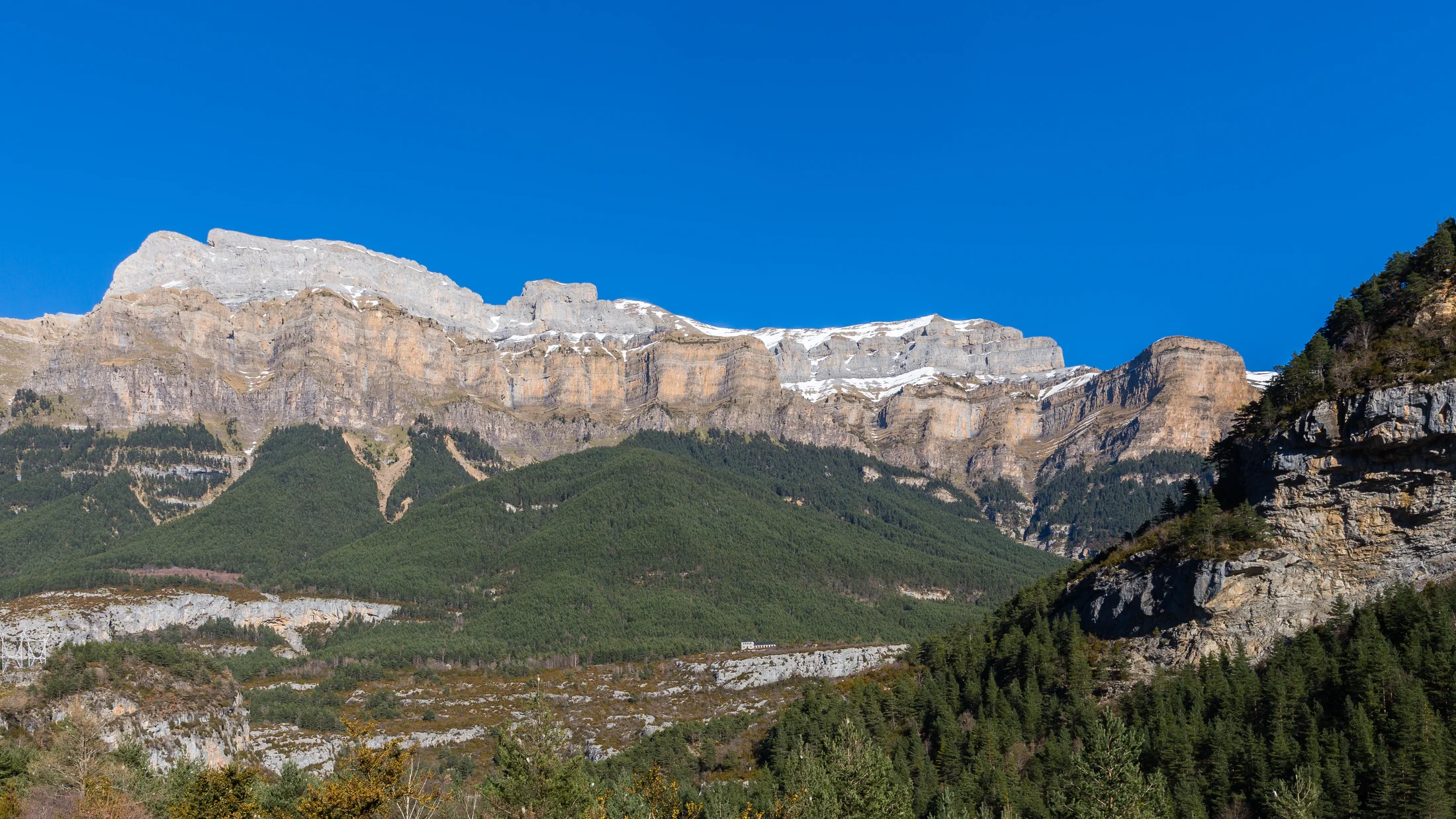
4.Ordesa and Monte Perdido National Park: emblematic high mountain
The GR-11 around Ordesa–Monte Perdido brings towering cliffs, hanging valleys, and biodiversity protected since 1918. Trails are steep and exposed in places, so fitness and surefootedness matter. A raven’s croak echoes off limestone walls like a drumbeat.
- Location: Parque Nacional de Ordesa y Monte Perdido, Huesca.
- Terrain: limestone ledges, balcony paths, steep zigzags to cols, occasional cables on airy traverses.
- Best time: July–September; early autumn often stable; avoid lingering snow unless equipped and experienced.
- Ideal for: experienced mountain hikers used to exposure and long carries between huts or towns.
- Lodging and prices:
- Refugios guardados on the park’s periphery and approach valleys: bed 20–30 €; half-board 50–65 €.
- Village lodging in Torla, Broto, or nearby: 60–140 € per room.
- Shuttle buses operate seasonally to control access; check current schedules before committing.
- What to do:
- Plan days that combine the
etapas GR-11through Añisclo or Góriz approaches with margin for weather delays. - Target classic viewpoints and cirques on rest afternoons if legs allow.
- Connect with the broader network of
refugios GR-11to tailor length without losing the park’s highlights.
- Plan days that combine the
Wayfinding is good, but bring solid maps and offline tracks; cliffs and fog can complicate decision-making.
5.Benasque and Posets–maladeta: summits, glaciers and serious effort
Here the Senda Pirenaica runs near Spain’s loftiest cluster—Aneto–Maladeta and Posets—where granite ridges, cirques, and remnant glaciers shape the skyline. Demanding passes and rough footing mean shorter distances feel like full days. Thin air smells faintly of crushed quartz and cold wind.
- Location: Benasque valley and Parque Natural Posets–Maladeta, Huesca.
- Terrain: boulder fields, steep cols, high alpine lakes, occasional snow patches well into summer.
- Best time: July–September for predominantly snow-free lines; outside this window, expect snow and ice on north aspects.
- Ideal for: strong trekkers with alpine experience; those considering side ascents or linking with high variants.
- Lodging and prices:
- Guarded huts in the massif: bed 20–30 €; half-board 50–65 €.
- Benasque/Eriste lodging: 60–140 € per room; hostels 20–40 € per bed.
- Mountain taxis operate to some trailheads in season; budget 10–20 € p.p. depending on route.
- What to do:
- Use the
GR-11 mapto combine core stages with a hut-to-hut mini-circuit if weather opens a multi-day window. - Plan a rest night in Benasque for resupply and forecasts.
- For skilled parties, consider non-technical summits near the trail on stable days; always start early.
- Use the
Daily ascents often exceed 1000 m, so bake in contingency time for storms, heat, or fatigue.
6.La Cerdanya and Ripollès: eastern transition and lived-in landscapes
As you swing east, valleys broaden, villages dot the floor, and forests alternate with grazed meadows. The GR-11 flows more smoothly here, rewarding longer strides between mellow passes. The smell of woodsmoke and fresh hay lingers at dusk in stone villages.
- Location: La Cerdanya and Ripollès, Catalonia.
- Terrain: mixed forest paths, pastoral tracks, gentle cols, some rocky interludes on ridges.
- Best time: long season from late spring to October; shoulder months are excellent for cool walking.
- Ideal for: trekkers seeking moderate gradients, cultural stops, and frequent services; good for families and first-time multiday hikers.
- Lodging and prices:
- Rural hotels and pensions: 60–120 € per room; hostel beds 20–35 €.
- Refugios guardados sprinkled along high ground: bed 20–30 €; half-board 45–60 €.
- Campsites in valley towns: 10–20 € p.p. plus pitch.
- What to do:
- Sample Catalan cuisine and village markets on rest afternoons.
- Walk longer
etapas GR-11with flexible cutoffs to towns for weather or rest. - Trace forested ridgelines using the
GR-11 mapto weave in shade and water on hot days.
Public transport webbing (buses and regional trains) makes start–finish combos easier than in remote central sectors.
7.Cap de Creus: Mediterranean finale and sharp contrasts
The final push turns to schist headlands, calas, and the clean line of the Mediterranean horizon. Weather shifts to sea breezes and bright light, with rocky coastal paths rewarding careful footwork. Salt and thyme ride the wind as waves clap against the point.
- Location: Cap de Creus, finishing near Cadaqués/Port de la Selva, Girona.
- Terrain: rocky coastal singletrack, short steep ups/downs, sun-exposed ridges above turquoise coves.
- Best time: spring and autumn for cooler temps; early summer is feasible with early starts; high summer heat requires caution.
- Ideal for: walkers who want a symbolic finish, photographers, and anyone seeking a sea-to-summit narrative in reverse.
- Lodging and prices:
- Coastal hotels and guesthouses: 70–160 € per room; pensions 30–50 € p.p.
- Campsites near towns: 10–20 € p.p. plus pitch.
- Meals and cafés abundant; budget 15–25 € for lunch plates.
- What to do:
- Knit final
etapas GR-11to touch the lighthouse spurs and celebrate at the shore. - Swim at sheltered coves after early starts to avoid heat.
- Cross-check your
GR-11 mapfor protected area rules on camping and fire; much of Cap de Creus is a natural park with strict regulations.
- Knit final
Rail and bus links via Figueres and Girona make exits straightforward after your toes hit the water.
Interactive Map: Key Locations and Stage Links
Use the interactive map embedded in this article to visualize the GR-11 backbone, key huts, villages, trailheads, and elevation profiles. You can toggle layers for guarded huts, free shelters, water points, and public transport hubs. Heat shimmers faintly above a ridge line on the altitude graph.
Try this workflow:
- Filter by duration to reveal 3–4, 7–10, or 14-day blocks, then inspect cumulative ascent per block.
- Tap a stage to open brief notes on terrain, water reliability, and nearby lodging.
- Export GPX/KML for selected stages to your preferred GPS app; ensure you also download offline topographic tiles.
- Flag snow-prone passes and shaded north-facing traverses; create a plan B line that rejoins the main trail within a day.
- Save your custom selection so you can revisit it from your phone and refine bookings.
If you’re planning a family-friendly option or a high-mountain focus, the map’s filters speed up decisions and replace guesswork with clear, map-based choices.
Where to Sleep and How to Move: Huts and Transport
Staying overnight: hut types, bookings and prices
On the GR-11, you’ll find four main lodging types: guarded huts (staffed with meals), free shelters (basic, unmanned), hostels/pensions/hotels in towns, and campsites. A guarded hut, sometimes called a “refugio guardado,” offers bunks, blankets, dinners and breakfasts; a “refugio libre” is a simple shelter where you must bring sleeping kit and food. A pot of soup steams in a hut dining room as boots dry by the door.
- Bookings:
- July–September: reserve guarded huts and popular town lodgings weeks ahead.
- Shoulder seasons: still book weekends; reach out to confirm hut opening dates.
- Price ranges (typical):
- Guarded hut bed: 20–30 €; half-board: 45–65 €.
- Village hostel/guesthouse: 20–40 € p.p. in dorm; 60–120 € per private room.
- Campsites: 8–15 € p.p. plus 10–20 € per pitch.
- Tips:
- If a hut is full, adjust by combining shorter
etapas GR-11into a longer day to a village. - Use regional hut networks and the map’s “refugios GR-11” layer to locate alternatives.
- If a hut is full, adjust by combining shorter
Always carry a backup (bivy kit or flexible transport) if weather or capacity forces a change.
Getting there and back: transport and access
Public transport anchors both ends and many hubs mid-range. Trains and buses reach Irun/Hondarribia for Cabo Higuer and Figueres–Girona for Cap de Creus; valley buses serve towns like Benasque, Panticosa, and La Cerdanya. The diesel scent of a morning bus mixes with coffee as trekkers gather at the stop.
- Entry/exit points:
- West: Irun/Hondarribia (train/bus).
- Central: Panticosa/Sallent de Gállego, Benasque (buses; seasonal mountain taxis to higher trailheads).
- East: Puigcerdà, Ripoll, Ribes de Freser (regional trains/buses); Figueres to coastal towns.
- Combining transport:
- Park one car at your exit and use bus/taxi to the start.
- Use seasonal shuttles for protected valleys (e.g., Ordesa’s access controls in peak season).
- Pre-book mountain taxis when early starts are essential or buses don’t align.
- Practical:
- Confirm timetables a few days before; mountain services can vary by season and weather.
- Mark parking spots and access restrictions on your
GR-11 mapto avoid surprises.
When in doubt, ask local tourism offices or hut wardens; they know recent changes and road conditions.
Gear, Safety and Protected Areas
What to pack and how to navigate
Packing pivots on your chosen etapas GR-11, season, and access to huts. Keep base weight low but don’t omit essentials for cold rain at altitude even in July. The metallic tang of sleet on the wind is your cue to add layers fast.
Essentials for most 3–7 day blocks:
- Footwear: broken-in trekking boots or sturdy trail shoes with grip.
- Clothing: moisture-wicking layers, warm mid-layer, waterproof jacket/pants, hat/gloves even in summer.
- Sleep: light bag or liner if using huts; full sleeping setup only if you plan to bivy/camp where legal.
- Navigation:
- Paper
GR-11 mapat 1:25,000–1:50,000 for your block. - Phone with offline GPS tracks and topo tiles; carry a battery bank.
- Simple compass for poor visibility.
- Paper
- Hydration/food: water treatment, 2–3 L capacity, energy-dense snacks, and 1–2 days of reserve calories.
- Misc: first-aid kit, blister care, sun protection, headlamp, repair tape, trekking poles.
Tips to reduce weight:
- Share group gear (first-aid, power bank, repair).
- Choose a shelter strategy—hut half-board cuts stove/fuel weight; camping requires more.
Before you plan your GR-11, download and verify GPX for chosen stages; compare several sources and cross-check with IGN data for closures or reroutes.
Mountain safety: snow, evacuation and first aid
Risks concentrate on exposed traverses, late-lying snowfields, lightning, and heat. Early season, north-facing cols can hide icy steps that turn routine ground into a fall hazard. The ozone smell before a storm warns you to descend and wait it out.
- Prevention:
- Check daily forecasts and hut wardens’ notes; avoid committing to high passes with thunder predicted.
- In June/early July, carry light traction and poles if snow is likely, or choose lower variants.
- Start early to dodge afternoon storms and heat.
- When to hire a guide:
- If snow, technical terrain, or navigation doubts exceed your experience.
- Emergency basics:
- Carry emergency contacts saved and written; know regional rescue numbers.
- In an accident, protect from exposure, control bleeding, and call for help with precise location (use your app’s coordinates).
- Practice the STOP method: Stop, Think, Observe, Plan, then act deliberately.
Build a conservative plan that leaves margin each day; time is your best safety gear.
Permits, rules and nature protection
Protected areas along the GR-11 include national parks, natural parks, and reserves with specific rules. Wild camping and fires are often restricted or banned, and dogs may need leashes or be prohibited in certain zones. The earthy smell of crushed needles reminds you this is home to chamois, bearded vultures, and shepherds.
- Check ahead:
- Park regulations for camping/bivouac windows, fire bans, drone restrictions, and dog rules.
- Seasonal shuttle or access controls (e.g., valley closures or quotas).
- Good practice (Leave No Trace):
- Pack out all waste; disperse small groups; stay on durable surfaces.
- Filter/avoid contaminating water sources; keep soaps out of streams.
- Respect livestock and open/close gates; give shepherd dogs space.
- For foraging (mushrooms, plants): follow local permissions and limits; when in doubt, don’t pick.
When you’re unsure, ask a hut warden or local ranger; they balance conservation with access and know current constraints.
Choosing Your Section, Faqs and Next Steps
How to choose your section
Start with time, then match terrain and services to your experience. If you have 3–4 days, choose a micro-traverse with reliable exits; for 7–10 days, pick one massif and allow a rest day; for 14 days, link two regions with a logical transport handoff. The crisp scent of alpine morning tells you to keep plans simple and margins generous.
Use these filters:
- Time available:
- 3–4 days: Irati or La Cerdanya/Ripollès for moderate gradients and frequent services.
- 7–10 days: Tena–Panticosa or Ordesa for alpine flavor with solid access.
- 10–14 days: Benasque plus La Cerdanya for contrast and easier exits.
- Experience:
- New to multiday: prioritize hut-rich, moderate sectors with clear signage.
- Seasoned: central Aragon or Posets–Maladeta, with snow-savvy timing.
- Logistics:
- Anchor at rail/bus hubs; confirm shuttles and hut openings before you lock dates.
- Weather window:
- If snow persists, pivot to lower variants and forested sections.
Plan your GR-11 with the interactive map, lock beds in guarded huts during peak months, and sketch Plan B exits for storms.
Frequently asked questions
How long does the full Gr-11 take?
Most hikers need 35–50 days depending on pace, weather, and whether they add or skip town detours. Plan rest days every 7–10 days.
What are the best months to go?
High-mountain sectors are best July–September; western forests and eastern valleys extend into late spring and October with care. Early season snow persists on north aspects.
Do I need to reserve mountain huts?
From July to September, yes—book guarded huts well in advance. In shoulder seasons, still reserve weekends and check opening calendars.
How does the Gr-11 relate to Gr-10 and Hrp?
GR-10 runs the French side; HRP (Haute Randonnée Pyrénéenne) threads a higher, wilder line. You can occasionally cross borders or swap in an HRP variant for a day if conditions and skills allow.
Are there recommended variants?
Local variants bypass snow-prone cols or add scenic lakes; verify each on the GR-11 map, confirm waymarking, and ensure you can rejoin within a day.
Book your experience — discover outdoor activities in Spain with providers verified by Picuco.
Conclusion
Choose one of the seven sections to match your time and skill, then let the interactive map turn ideas into a clear, day-by-day plan. Book guarded huts early for July–September, sketch backup exits, and carry both paper maps and offline GPS tracks. A thin blue line on your map becomes real as boots, weather, and villages stitch the Pyrenees into your own Senda Pirenaica story.
If you want more than inspiration, use the resources in this article to refine stages, export GPX, and coordinate transport and overnight stays. When you’re ready, pack with intention, start early, and let the Atlantic-to-Mediterranean arc guide your pace and purpose.