Why Gentle Scenic Hikes Fit Perfectly After 60
Start soft and go far. If you’re 60-plus and curious about the countryside, hiking for seniors delivers health, safety, and genuine joy. A slow path lets your heart work steadily, your joints move smoothly, and your mind rest on open views instead of steep climbs. Think of the sound of wind through poplars, steady and kind.
Gentle routes with low elevation gain reduce strain on the heart and knees, lower the chance of slips on descents, and leave more energy for conversation and photographs. You move at your pace, not the mountain’s. Picture a level greenway where the old railway grade never bites, and you can look up at birds instead of down at rocky steps.
In this guide you will find practical tools to plan simple, scenic days out. We show distances, estimated times, surfaces, and “trails under 300 m elevation gain,” plus when to go, how to get there, and where to stay near rural services. Imagine a thermos on a shaded bench, steam curling up as you scan the horizon. Use the route summaries to pick your day, match distance to your condition, and enjoy Spain’s landscapes at ground level.
What hiking adds after 60
Walk to keep moving well. Gentle walking improves mobility in hips and ankles, helps balance through small stabilizing muscles, and supports cardiovascular health with moderate, regular effort. A bird’s call punctuates each breath, easy and unforced.
Social walks strengthen motivation and reduce loneliness, while natural light regulates sleep and mood. Choose “hiking for seniors” that is steady and scenic, like level riverside paths or greenways on compact gravel. Start with short loops—3 to 6 km—add pauses, and track how you feel during and after. The practical win: better endurance for everyday tasks and fewer aches from sudden, intense efforts.
What you will learn here
You’ll get the essentials to plan safe, rewarding days. We cover technical basics—distance, surface, low elevation gain trails—plus simple timing rules, the best seasons and hours, how to reach trailheads by car or public transport, and comfortable rural stays. The reedbeds of a lagoon rustle as you note your options.
You also get 10 senior-friendly trails, each scenic and under 300 m of elevation gain, with accessibility notes and services nearby. We close with safety tips and FAQs to solve common doubts. Keep this as a checklist, then build days that feel generous, not rushed.
Picuco te puede ayudar
Does something here catch your eye?
Tell us.
Write to us on WhatsApp or email: we answer questions, find the best options and help you sort out the booking.
The Essentials: Difficulty, Distance, and Elevation for a Comfortable Day
Choose with your head and your heart will thank you. Objective criteria make routes safer and more enjoyable for walkers over 60: easy ratings, modest distances, and trails under 300 m of total ascent keep effort smooth and predictable. Think of a railway-grade path that never surprises you with a sharp kick. The practical gain is confidence: you know what’s ahead and how long it will take.
- Difficulty: look for “easy,” “family,” or “adapted” routes that avoid rocky scrambles and narrow ledges.
- Distance: favor 3–8 km to start; stretch to 10–12 km if you already walk an hour most days.
- Surface: prefer compact gravel, firm dirt, or boardwalk; avoid long boulder fields or loose scree.
- Grade: sustained slopes under 6% feel gentle; short ramps can be steeper if they’re brief and well surfaced.
- Access: parking close to the start, benches every 1–2 km, shade, and clear waymarks reduce stress.
Use official trail boards, regional tourism pages, and Spain’s IGN Topo (ign.es) to confirm figures; railway greenways published by the Red de Vías Verdes keep gradients mild by design. The smell of pine resin by a waymark tells you you’re on track.
What “easy” and “adapted” really mean
Start by decoding labels. “Easy” for older adults typically means wide paths, stable footing, signed junctions, and “desnivel <300 m” (under 300 m of total ascent) spread across the route. A ribbon of compact gravel underfoot feels forgiving and predictable.
“Adapted” means features that improve safety and comfort: boardwalks over wet ground, railings on short bridges, steps with handrails, or wayfinding panels with distances. For example, 8 km on level terrain (0–2% grade) feels light; 8 km with frequent short climbs can double the effort for legs and lungs. Choose routes with poco desnivel—routes with little elevation—so your energy goes to looking around, not just pushing up. You’ll taste the salt on a coastal breeze and keep your breathing easy.
Practical tip: read the elevation profile like a skyline—broad, low waves are fine; saw-tooth spikes mean repeated ramps. If in doubt, pick the flattest half as an out-and-back.
Distance and time: adjusting to your condition
Match distance to your current routine. If you walk 30–45 minutes most days, plan 4–6 km on level terrain; if you comfortably walk an hour, 7–10 km can fit. Footfalls drum a steady rhythm on packed earth.
Use a simple rule-of-thumb time estimate:
- Base pace on the flat: 3–3.5 km/h for relaxed sightseeing.
- Add 10–12 minutes for every 50 m of ascent.
- Add pauses: 5 minutes every 25–30 minutes, plus a 15–20 minute scenic break.
Example: A 6 km level greenway at 3.2 km/h takes ~1 h 50 min; add 25 minutes of breaks to reach 2 h 15 min total. If a route is long, divide it into sections with clear turn-around points—bridges, cafes, or signed junctions—so you can shorten the day without worry. The clink of cups at a village bar makes an easy halfway marker.
Elevation gain: what “less than 300 m” means in practice
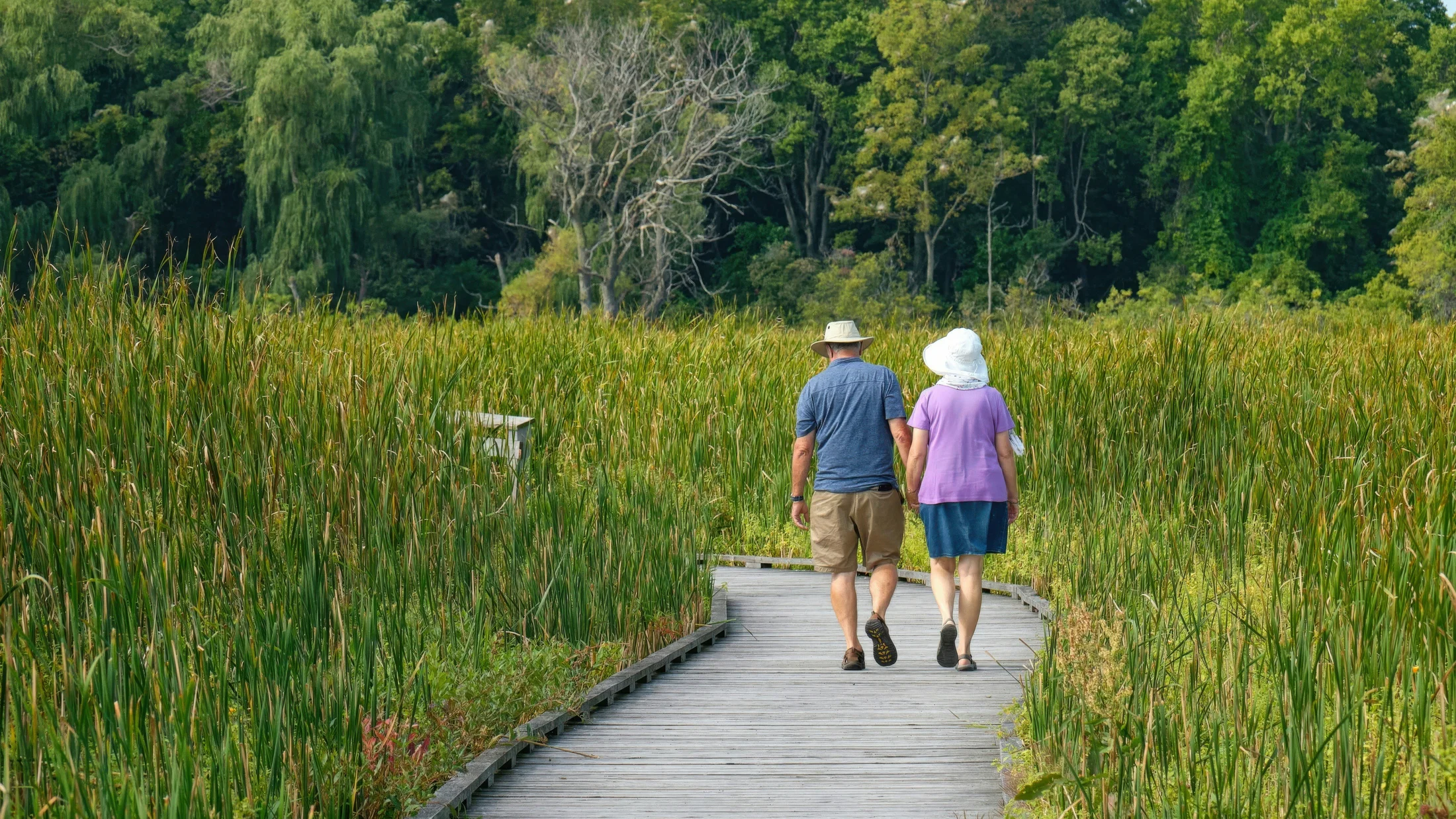
Total ascent sums every climb you do. Keeping it under 300 m spreads effort into gentle rises so your breathing stays even and your knees avoid long, pounding descents. A profile that rises like a soft hill and returns the same way feels kind on joints. You’ll hear your steps, not your pulse, on a wooden boardwalk.
How to check it:
- Study the elevation graph on maps from IGN, regional parks, or greenway websites.
- On apps, confirm “elevation gain” and zoom the profile to spot short steep ramps.
- On the ground, follow posts for
PR(short local routes) orGR(long trails) and read board panels with distance and ascent.
Example: If a 10 km loop shows 180 m of gain, expect a prolonged gentle rise and fall. If it shows 280–300 m, look for one or two more noticeable—but still manageable—ramps. Keep poles handy for balance; they transfer some load to arms and help on small steps. The faint crunch of gravel under a pole tip says you’re steady.
When To Go: Seasons, Light, and Safe Hours
Choose the time and the trail will reward you. For easy hiking routes in Spain, comfort and safety hinge on season, daily temperatures, and daylight. In spring and autumn, mild air and long light windows make planning simple; in midsummer, start early or later in the day to avoid heat stress. The scent of thyme releases at dawn as the path warms.
- Spring (March–May): Blooming landscapes, flowing streams, and migrating birds enrich even the gentlest walks. Mornings are cool; midday can warm quickly inland. Aim for 9:30–12:30 or 17:30–20:00. Carry a light layer for shade and breezes.
- Summer (June–September): Heat builds, especially away from the coast and in the south. Start at sunrise, finish by 11:00, or choose coastal promenades with sea breezes in the evening. Urban coastal paths offer frequent benches and cafes. Hear the hush of waves along a shaded esplanade.
- Autumn (October–November): Stable weather and warm colors reward slow walkers. In the north and at altitude, days shorten quickly; check sunset times and turn back with at least an hour of light to spare. Forest greenways are quiet and cool.
- Winter (December–February): Choose coastal or lowland routes with minimal shade in cold snaps. Late morning to early afternoon suits best (11:00–15:30), but watch for early dusk. Bring a windproof layer; breezes over lagoons can feel colder than the forecast. The sharp cry of a gull carries over still water.
Weather and safety checks:
- Read AEMET forecasts (aemet.es) the evening before and the morning of departure; avoid thunderstorm days on exposed promenades.
- Confirm sunrise/sunset for your location; add a 30–60 minute buffer to finish in daylight.
- After rain, prefer boardwalks and paved promenades; compact gravel drains well, but clay tracks can be slippery.
- In protected wetlands, check access hours for visitor centers; facilities often open 10:00–18:00 in season. A warm coffee from a center cafe sets the tone for a calm start.
Plan shade for summer and sun access for winter. Above all, align distance and start time so the gentlest route remains gentle from first step to last. Your shadow lengthens softly on the homeward leg.
Getting There and Staying Nearby
Short access makes a big difference. Easy beginnings—clear directions, reliable parking, or a simple bus-hop—set the tone for a relaxed day. For routes fáciles España, favor trailheads with well-signed access and nearby services. A chime at a level crossing reminds you this was once a railway, not a race.
Think in three parts:
- To the region (train, coach, or car).
- To the trailhead (local bus, taxi, or short drive).
- Back-up options (turn-around points, benches, cafes, and safe pick-up spots).
Reaching the trailheads: car, public transport, and the last mile
Driving is simplest for remote greenways and lagoons. Before you go, check if access roads are paved to the parking area; when unpaved, they’re usually short and suitable for standard cars in dry weather. Arrive early on weekends for closer, flatter parking. The soft thud of a boot on firm gravel promises an easy start.
Public transport opens many coastal paths, urban promenades, and some greenways:
- Trains connect major cities to coastal towns; from there, local buses or taxis handle the last 3–10 km.
- Intercity coaches often stop in county hubs; from a village, a pre-booked taxi can bridge the final few kilometers.
- For larger greenways, visitor centers can advise on adapted access points and parking.
Plan the last mile: mark the exact start on a map, note alternative entries with benches or cafes, and confirm if there are steps or ramps from street level. If you use a mobility aid, call the local tourist office the day before to confirm conditions at tunnels or boardwalks. The hollow echo in a short tunnel tells you the surface is even and the grade gentle.
Comfortable rural stays and useful services
Choose lodgings that make resting effortless. Look for rural hotels or B&Bs with lifts or ground-floor rooms, step-free showers, and breakfast included so you can start early. Crisp sheets and a kettle waiting in-room feel like a promise of an unhurried day.
Useful features near senior-friendly trails:
- On-site or nearby restaurant (300–800 m), especially in small villages with limited options.
- Pharmacist and basic groceries within a short walk or a brief drive.
- Parking on level ground close to the entrance.
- Reception hours that match your arrival and flexible check-out if you plan a midday rest.
Before booking, verify:
- Room level and lift availability, door widths if you use a mobility aid, and whether bathrooms are step-free.
- Breakfast times (early slots help in summer).
- Distance from lodging to trailhead by foot or car, and whether there is shaded parking. You’ll feel a cool draft in a stone hallway after returning from sunlit paths.
To compare options and check accessibility, consult the accommodation details and ask direct questions by phone or email; many rural hosts are happy to confirm step counts and shower types. When ready, explore comfortable rural stays and nature activities curated by Picuco to match your route and pace.
Ten Scenic, Low-gain Routes Perfect After 60
Below you’ll find ten gentle scenic hikes across Spain, all selected for beauty, services, and “trails under 300 m elevation gain.” Distances and ascent are based on official trail boards, IGN topographic maps, and greenway sources. The rustle of reeds, the hush of tunnels, and the murmur of waves will be your soundtrack.
Vía Verde de la Sierra (cádiz–sevilla): a level railway valley
Pick the Puerto Serrano to Coripe direction for a mild out-and-back. Walk 8–12 km total on compact gravel with roughly 80–150 m of total ascent, depending on turn-around point. You pass short lit tunnels and broad viaducts over the Guadalete; a swallow swoops through the arches.
- Distance/time: 10 km out-and-back in 3–3.5 hours at a relaxed pace with breaks.
- Surface: compact gravel; wide, stable, and well signed.
- Elevation: gentle railway grade, “rutas con poco desnivel,” gain typically under 150 m for 10 km.
- Access: parking at Estación de Puerto Serrano and Estación de Coripe; cafes at former stations.
- Why it suits seniors: consistent gentle grade, benches and shade in cuttings, easy wayfinding.
- Tips: bring a small light for tunnels; in warm months, start before 10:00. Services at both stations make planning simple.
Albufera of Valencia: flat paths by lake and rice fields
Circle a tranquil section along the lagoon’s edge and rice paddies near El Palmar. A 6–9 km loop on levee tracks and paved lanes stays virtually flat with under 30 m of ascent. At dawn and dusk, herons lift from the reeds and the air smells faintly of salt.
- Distance/time: 7 km in ~2–2.5 hours with birdwatching pauses.
- Surface: mixed—paved village lanes, firm dirt levees, short boardwalk segments at viewpoints.
- Elevation: essentially flat; “gentle scenic hikes” at their purest.
- Access: bus from Valencia to El Palmar; parking near the village and visitor spots.
- Why it suits seniors: benches at viewpoints, cafes within 1–2 km, continuous level terrain.
- Tips: best at sunrise/sunset for birds and cooler air; bring light binoculars and a cap. Extend along the lagoon boardwalks if energy remains.
Senda del Oso (asturias): easy greenway through a forested valley
Choose the stretch from Tuñón to Proaza for a calm, shaded walk. Plan 8–10 km out-and-back with 100–180 m total gain, following a disused railbed beside the Trubia River. The river chatters below as dappled light moves across the path.
- Distance/time: 9 km in ~2.5–3 hours at a sightseeing pace.
- Surface: compacted gravel and some asphalt through short tunnels and over stone bridges.
- Elevation: steady, low-grade climbing outbound, easy return.
- Access: parking at Área Recreativa de Tuñón; local buses/taxis serve Proaza. Visitor info boards at the start clarify distances.
- Why it suits seniors: wide track, gentlest grades, frequent shaded rests.
- Tips: carry a small headlamp for tunnels; enjoy cafes in Proaza for a midpoint break. Consider wildlife enclosures signed near the route.
Lake Sanabria (zamora): accessible shoreline paths
Stroll sections of the north shore between Playa Grande and Custa Llago for the flattest experience. A 5–8 km out-and-back keeps ascent under 80 m with options for short boardwalks and lakeside promenades. Water laps softly at granite slabs by your feet.
- Distance/time: 6 km in ~2 hours including viewpoint pauses.
- Surface: mixed—paved promenade segments, firm dirt tracks, short wooden walkways; avoid rocky coves if balance is a concern.
- Elevation: minor undulations; choose the promenade-heavy stretches for the easiest terrain.
- Access: parking at Playa Grande and signed areas along the shore; seasonal services and cafes.
- Why it suits seniors: pick-and-choose segments with benches, quick access to services, and easy turn-backs.
- Tips: arrive early in July–August; in shoulder seasons, bring a windproof layer for lakeside gusts.
Costa Brava’s Caminos de Ronda (baix Empordà): a short, even coastal stretch
Select a gentle piece of the GR-92 between Sant Antoni de Calonge and Platja d’Aro. An out-and-back of 6–8 km on paved seafront and level clifftop promenade stays under 120 m of total ascent with only brief ramps. Foam hisses at your side as waves roll into small coves.
- Distance/time: 7 km in ~2–2.5 hours, more with photo stops.
- Surface: mostly paved promenade and well-built paths; occasional steps with handrails—turn before any extended staircase.
- Elevation: low overall; avoid sections with multiple stair runs to stay within “trails under 300 m elevation gain.”
- Access: regular buses between coastal towns; ample seafront parking off-season.
- Why it suits seniors: frequent benches, cafes, and easy wayfinding, with big views for minimal effort.
- Tips: go in spring or late autumn to avoid crowds; sturdy walking shoes with grip help on occasional wet stone.
Marismas del Odiel (huelva): boardwalks and birdlife on level ground
Explore circular walks near the Anastasio Senra visitor center. Combine short loops for 4–8 km on boardwalks and firm tracks with negligible ascent (<20 m). The call of waders stiches the silence over silver water.
- Distance/time: 6 km in ~2 hours with birdwatching stops.
- Surface: wooden walkways, compacted earth, and short paved sections; excellent footing.
- Elevation: virtually flat; ideal for “senior-friendly trails.”
- Access: paved road to the center; parking, toilets, and information on conditions and birds.
- Why it suits seniors: infrastructure, shade structures, and flexible loops with clear signage.
- Tips: bring binoculars, sunscreen, and a brimmed hat; check tides and opening hours with the center to time sightings.
Vía Verde del Plazaola (navarra): forests, viaducts, and easy grades
Walk the stretch from Lekunberri toward Uitzi through cool woodland. Plan 8–10 km out-and-back with 120–200 m total ascent; old railway design keeps slopes steady. Your steps echo softly in short, damp tunnels, cool even in summer.
- Distance/time: 9 km in ~2.5–3 hours with breaks.
- Surface: compact gravel and occasional paved segments; well signed and maintained.
- Elevation: modest, continuous grade outbound; easy return.
- Access: parking and visitor info at Lekunberri; regional buses connect from Pamplona and San Sebastián with local transfers.
- Why it suits seniors: shade, steady grades, and services in town for pre/post-walk coffee and meals.
- Tips: carry a light for tunnels; after rain, gravel drains well but watch for puddles at tunnel mouths.
A Coruña Seafront Promenade: urban coast without climbs
Pick a 5–8 km section between the Tower of Hércules and the central beaches. This promenade is largely flat and wide, with benches every few hundred meters and frequent cafes. Gulls wheel overhead as surf booms against the rocks below.
- Distance/time: 6 km in ~1.75–2.25 hours with view stops.
- Surface: paved, level footway; pedestrian crossings are frequent and ramps are common.
- Elevation: minimal; tiny rises near viewpoints only.
- Access: city buses and taxis serve multiple entry points; parking garages and street parking nearby.
- Why it suits seniors: urban services, clear wayfinding, lighting for evening strolls, and sea views without steps.
- Tips: bring a light windbreaker; in winter, choose midday for warmth. Museums and cafes can anchor your halfway rest.
Trasona Reservoir Loop (asturias): calm water, calm path
Circle part of the Embalse de Trasona on level paths and paved lanes. Choose a 5–7 km loop with under 60 m of gain on firm surfaces used by local walkers. Oars slice the water as rowers train along the far shore.
- Distance/time: 6 km in ~1.75–2 hours at a relaxed pace.
- Surface: mixed—paved lanes and compact dirt; good footing in all seasons.
- Elevation: essentially flat; one or two tiny rises.
- Access: easy by car from Avilés/Corvera; local services close by, including cafes.
- Why it suits seniors: short, level circuits with benches and easy parking.
- Tips: in cooler months, afternoons feel warmer; around the dam, breezes can be brisk—pack a hat and gloves if sensitive to cold.
Windmills of La Mancha (campo de Criptana): culture on gentle ground
Enjoy a short, mostly level cultural route skirting the base of the hilltop molinos and crossing the surrounding plain. Build a 4–6 km loop with under 80 m of ascent by favoring perimeter lanes and village streets, reserving optional short climbs to a windmill if you feel fresh. Blades creak softly when the wind rises over open fields.
- Distance/time: 5 km in ~1.5–2 hours with photo stops.
- Surface: paved village streets and firm dirt farm lanes; avoid steeper cobbles to keep it gentle.
- Elevation: low overall; optional brief, steeper spur to a mill viewpoint.
- Access: straightforward by car; regional buses link nearby towns; ample village services.
- Why it suits seniors: flexible route, cultural interest, cafes and museums within easy reach.
- Tips: go mornings in summer and mid-afternoon in winter; combine with a local lunch to round out the day.
What To Do Along The Way: Nature, Culture, and Little Joys
Make the walk richer without making it harder. Easy routes give time and space for simple activities that deepen your experience. A camera clicks softly as a heron lifts in slow motion.
- Birdwatching: lagoons, estuaries, and reservoirs—like Albufera, Marismas del Odiel, and Trasona—offer year-round sightings. Bring compact 8x32 binoculars and a pocket species list; spend five minutes at each hide rather than scanning while walking.
- Landscape photography: early and late light softens contrasts and flatters gentle terrain. Use a smartphone’s wide-angle for big skies and a short telephoto for distant windmills or viaduct arches.
- Cultural stops: windmill museums, railway station visitor centers, and lighthouse viewpoints add meaning to the miles. Choose one 20–30 minute cultural stop per outing to avoid fatigue.
- Mobility micro-exercises: every 30–40 minutes, do ankle circles, gentle hamstring stretches, and shoulder rolls. Two minutes here keeps the next kilometer smooth.
- Picnic and local gastronomy: a half sandwich and fruit at a shaded bench works, then finish with a village lunch—rice dishes near Albufera, seafood on the Costa Brava, or hearty stews in Asturias. The aroma of grilled fish drifting from a chiringuito may be the day’s highlight.
- Interpretation moments: read one trail panel fully, identify three trees by leaf, or learn one bird’s call. Light cognitive goals keep the mind engaged and the pace natural.
Tailor the plan to energy and interest. If you love birds, shorten the distance and double the time at a hide; if you prefer history, loop through a museum and trim the walking. Adaptability is the superpower of gentle walking.
Practical Tips for a Safe, Enjoyable Day
Simple habits protect comfort and confidence. Plan a calm rhythm, pack smart, and listen to your body as much as to the trail. A sip of cool water tastes sweeter when you’re never rushed.
Finding your pace and scheduling breaks
Move slowly, not stop-start, on “senderos para mayores de 60.” Set a conversational pace where you can speak in full sentences, then keep it steady for 20–30 minutes before a short rest. The hush of leaves overhead deepens as your breathing stays even.
- Breaks: 3–5 minutes every 25–30 minutes, or sooner if warm; one longer 15–20 minute stop at the day’s midpoint.
- Place your pauses: choose benches, shade, or leeward spots out of wind; viewpoints are ideal but don’t skip shelter on hot days.
- Use landmarks: plan rests at signed junctions, bridges, visitor centers, or cafes. Your watch and the next waymark keep you honest.
- Turnaround rule: if fatigue or pain appears, turn around immediately rather than “pushing to the next point.” The goal is pleasure, not proof.
What to wear and carry for comfort
Carry less, but carry smart. Stable shoes with good grip, a hat, and simple layers solve 90% of needs on senior-friendly trails. The soft rustle of a light shell means you’re ready for a breeze.
Essentials:
- Footwear: walking shoes with cushioned midsoles and reliable tread; avoid brand-new shoes on long days.
- Poles: telescopic poles improve balance and reduce knee load on small steps.
- Sun and weather: brimmed hat, sunglasses, sunscreen (SPF 30+), light wind shell; add a thin fleece in shoulder seasons.
- Hydration and food: 1–1.5 liters of water (more in heat), small snacks (nuts, fruit, sandwich).
- Basics: lightweight first aid kit (plasters, blister care, pain relief you tolerate, antiseptic wipes), ID, small cash.
- Communication: fully charged phone, power bank if you rely on GPS, and emergency contact info written on a card.
- Comfort extras: a foldable sit pad or small stool makes breaks kinder; a second pole provides “backup” on rocky steps.
Pack items within easy reach and review at the car or room: can you access water, hat, and a layer without rummaging? Keep the pack under 10% of body weight for ease.
Health and first aid: prepare and know when to stop
Prevention starts before the door. If you manage heart, lung, or metabolic conditions—or take blood pressure, blood thinner, or diuretic medications—ask your clinician about suitable distances, heat precautions, and any limits for elevation and intensity. The quiet tick of a pillbox at breakfast is part of your plan.
- Medication: carry doses you need during the outing plus one spare; set a phone reminder for timed meds. Keep a list of active conditions and medications in your wallet and phone.
- Warning signs: unusual breathlessness, chest tightness, lightheadedness, severe calf pain, or confusion are red flags—stop, rest in shade, hydrate, and call for help if symptoms persist.
- Heat and hydration: sip regularly; in hot weather, add oral rehydration salts to one bottle. If urine stays dark, increase fluids and shorten the route.
- Falls: if you stumble often, slow down, use both poles, and shorten the route. After any head strike or if pain worsens, seek medical review.
- First aid skills: a short first aid course tailored to outdoor scenarios builds confidence. Practice taping hot spots on your feet to avoid blisters.
Plan conservative distances at the start of a trip, then lengthen as your body adapts. Always leave room to return fresh, not spent.
Accessibility and Simple Adaptations
Look for features that make paths forgiving. An accessible route is more than flat ground; it’s about width, footing, safe edges, and places to pause. The reassuring feel of a handrail on a short bridge steadies the mind as well as the body.
What to check before you go:
- Width and surface: at least 1.2–1.5 m wide for comfortable passing; compacted gravel, firm dirt, boardwalk, or pavement.
- Gradients: long ramps under 6% with short level landings; avoid extended steps without handrails.
- Edges and supports: railings on bridges, non-slip strips on boardwalks, secure edges above water.
- Amenities every 1–2 km: benches, shade structures, water points, and toilets near centers or towns.
- Wayfinding: clear posts at junctions and at least one map panel per loop with distances and times.
- Safety: mobile coverage at key points, signed emergency access tracks, and identifiable landmarks for meeting a taxi or friend if you cut the route.
Adapt your outing to your needs:
- Split a loop into out-and-back segments to control elevation gain and footing.
- Use alternate starts with closer parking or fewer steps (visitor centers often indicate these).
- If you use a wheelchair or mobility scooter, ask about designated accessible circuits and maximum slope; many wetlands and promenades provide suitable routes with continuous boardwalk or pavement.
- Pair walkers with different speeds by setting meeting points with benches or cafes; let faster companions add short add-ons while you rest comfortably.
Confirm details with park offices, greenway managers, or local tourist information. A two-minute phone call the day before often saves twenty minutes of uncertainty at the trailhead.
Frequently Asked Questions
What distance is reasonable after 60?
If you walk 30–45 minutes most days, start with 4–6 km on flat ground and build gradually. If you comfortably walk an hour, 7–10 km may suit. Keep elevation gain under 300 m so effort stays even, and add short pauses every 25–30 minutes. A steady, conversational pace beats stop–start bursts.
How can I reduce the risk of falls?
Choose firm, wide paths, use telescopic poles, and slow down on uneven patches. Lift your toes deliberately to avoid shuffles, and rest when you feel fatigued. Good tread, a brim to block glare, and attention on short down-steps matter; avoid wet rock and leaf piles after rain.
What should I do if joint pain appears mid-walk?
Stop, rest in shade, and take small sips of water. If you carry a pain reliever approved by your clinician, use it; add gentle range-of-motion movements once pain eases. Cut the route short and avoid long descents; if pain worsens, seek medical evaluation rather than pushing through.
How do I find trails with elevation gain under 300 m?
Check official elevation profiles on park boards, IGN maps (ign.es), and greenway sites; look for “easy,” “family,” or “adapted” labels. Focus on river paths, rail-trails (Vías Verdes), lagoons, and seafront promenades, which are designed or formed by level water lines and gentle grades.
Can I bring my dog on these routes?
Many promenades and greenways allow dogs on a lead; protected wetlands may have restrictions to protect wildlife. Check local signs at the trailhead and always carry waste bags. Avoid hot midday hours, bring extra water, and watch for paw sensitivity on hot pavement.
When should I consult my doctor before hiking?
If you have heart or lung disease, diabetes, balance issues, or take medications affecting hydration or blood pressure, ask your clinician about distance, heat, and rest plans. Also check in after any new or worsening symptom on a walk, such as chest tightness, severe dizziness, or unusual shortness of breath.
Book your experience — discover active tourism activities in Spain with providers verified by Picuco.
Conclusion
Gentle terrain brings big rewards. By choosing routes with little elevation gain, you protect your heart and joints, lower fall risk, and free attention for views, birds, and conversations. A soft breeze on a level path is an invitation, not a test.
Plan conservatively: 3–8 km to start, steady pace, and short breaks in shade. Check weather and daylight, confirm firm surfaces and access, and carry simple essentials—water, layers, poles, and a small first aid kit. Use official profiles to keep elevation gain under 300 m and pick routes with benches, railings, and clear signage.
From green valleys in Asturias to luminous wetlands in Huelva and level coastal promenades in Galicia and Catalonia, Spain is rich in senior-friendly trails. Choose one route, set an easy hour to start, and enjoy an unhurried day outdoors. If you want more ideas or comfortable places to stay nearby, explore curated options at Picuco and build a season of calm, scenic walks that feel as good as they look.