The essentials of Costa da Morte

  • • Praia de Carnota: 7.5 km of unbroken sand, Galicia's longest beach
  • • Cabo Vilán lighthouse (1896): Spain's first electric lighthouse, still active on the cliffs
  • • Cabo Touriñán: Iberian Peninsula's westernmost point, accessible on foot in 20 minutes
  • • Active Traba dunes in Laxe with protected psammophilous flora
  • • Muxía-Fisterra Coastal Way: cliff-top stage with open Atlantic views

Description

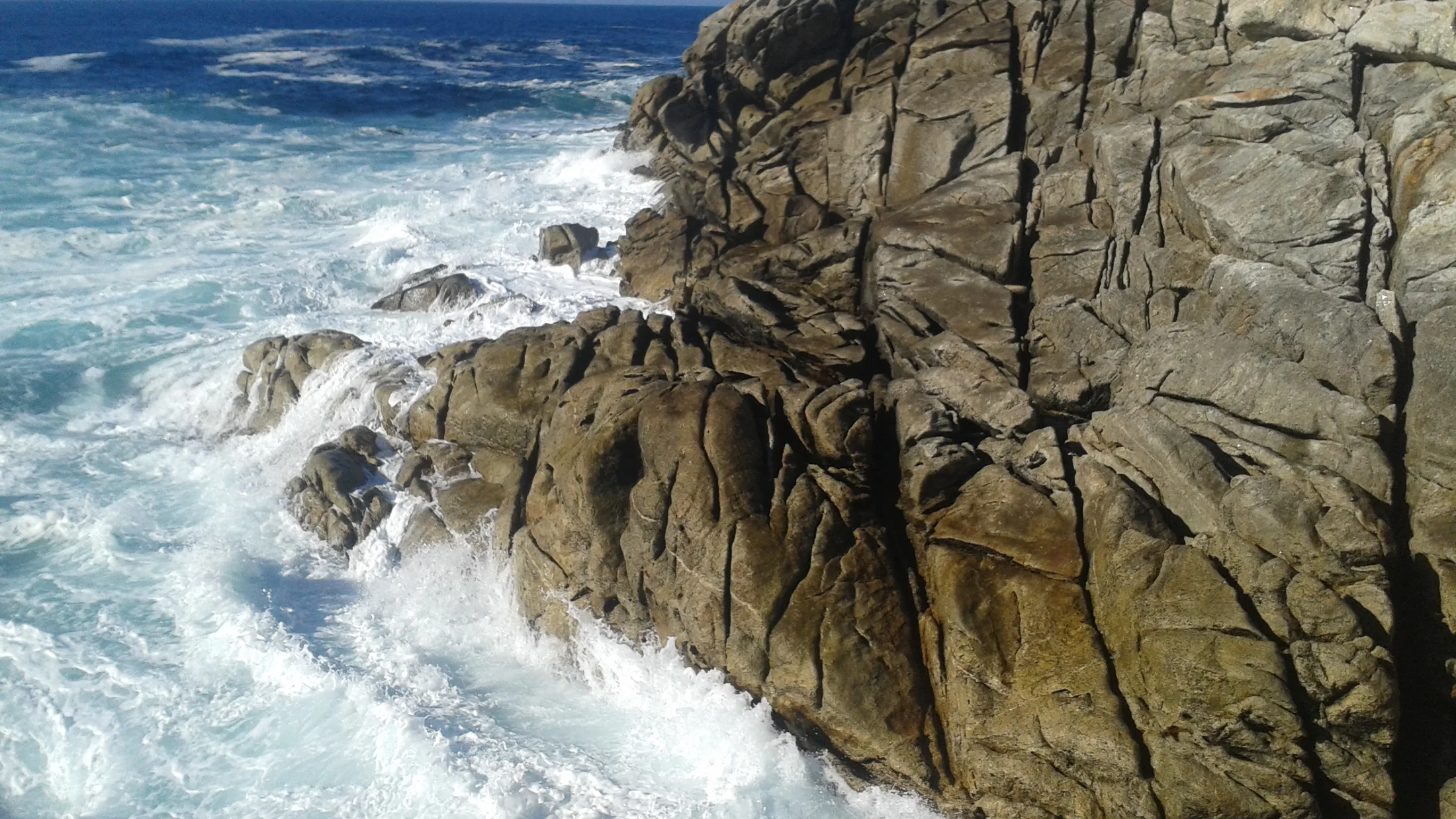
The Costa da Morte is the westernmost stretch of Galicia, where the Atlantic coast meets a shoreline of cliffs, headlands and rias running from Cabo de San Adrián north of Malpica to the Ría de Muros and Noia in the south. The name is not a literary device: the seabed in this sector accumulates hundreds of documented shipwrecks since the Middle Ages, the result of westerly winds, subsurface currents and the absence of natural sheltered harbours along many stretches. The sea mist that frequently settles over the horizon in summer reinforces the sense of an extreme coast. The lighthouses — Cabo Vilán, active since 1896 and Spain's first to run on electricity; Punta Nariga; and Cabo Touriñán, the Iberian Peninsula's westernmost point — are the markers that structure the coastal landscape.

The underlying geology explains the harshness of the coastal profile. The rock is mainly Hercynian granite, outcropping in large rounded masses shaped by differential erosion and in platforms that drop abruptly into the sea. At Carnota lies Galicia's longest beach: 7.5 kilometres of unbroken sand framed between the Monte Pindo — the Celtic Olympus of local oral tradition — and the Ría de Corcubión. Praia de Carnota, Praia de Laxe and Praia de Traba are the most extensive and visited. The beaches of Trece, Nemiña and Rostro are more enclosed, reached by narrow tracks that limit visitor flow. The Traba dunes, the most extensive active dune system on the Costa da Morte, support a specific psammophilous flora including Artemisia crithmifolia and Otanthus maritimus.

Artisanal fishing and shellfish gathering have structured coastal community economies for centuries. The fishing guilds of Laxe, Camariñas, Muxía and Cee manage barnacle, sea urchin and mussel beds supplying markets across Galicia and northern Spain. The percebes of the Costa da Morte, harvested manually by percebeiros on surf-washed cliff platforms during periods of relative calm, command reference prices in the fish markets of Santiago de Compostela and Vigo. This bond between community, sea and fishery resource is visible in the ports themselves: the harbours of Malpica, Laxe and Camariñas maintain daily activity from artisanal vessels and catches being landed.

The Camino de Santiago along the Costa da Morte — also known as the Muxía-Fisterra Way — connects Santiago de Compostela with the two most important Atlantic sanctuaries of the Jacobean cult: the Santuario da Virxe da Barca in Muxía, its façade directly facing the sea, and Cabo Fisterra, the medieval pilgrims' 'end of the world'. The stage between Cee and Muxía partly follows the coastal path with open Atlantic views. Beyond the pilgrimage route, the Camariñas area holds some of the most valued coastal walking in Galicia, with the PR-G 110 trail running along the cliffs between Praia do Ézaro and Cabo Vilán lighthouse.

Practical information

Everything you need to know for your visit to Costa da Morte

How to get there
From Santiago de Compostela take the AG-55 towards Carballo, then local roads to Malpica, Laxe or Camariñas. Distances: 65 km to Malpica (55 min), 90 km to Camariñas (1 h 15 min). Bus from Santiago to Cee and Camariñas operated by Arriva Noroeste with limited frequency.
Area Information
The area covers the municipalities of Malpica, Ponteceso, Laxe, Vimianzo, Camariñas, Muxía, Dumbría, Cee and Carnota in the province of A Coruña. The nearest regional capital is Santiago de Compostela (65-95 km depending on the coastal location).
Geography
Hercynian granite coast with cliffs, headlands and small rias. Rocky barnacle platforms. Active dune systems at Traba and Carnota. Monte Pindo (627 m) closes the southern sector. Cabo Touriñán is the peninsula's westernmost tip.
Flora & Fauna
Coastal vegetation of gorse and heathland on cliffs. Psammophilous dune flora: Artemisia crithmifolia, Otanthus maritimus, Euphorbia paralias. Seabirds: shag, yellow-legged gull and northern gannet. Common bottlenose dolphin frequent in coastal waters.

Things to do

Find the best plans and things to do in Costa da Morte

18

Accommodations

Best accommodation options in Costa da Morte

Loading accommodation options...

Frequently Asked Questions

Get answers about Costa da Morte

Praia de Laxe is the most complete option for family swimming: wide, easily accessible, with seasonal services (lifeguard, showers, beach bar) and an orientation that provides some shelter from westerly winds. Praia de Carnota offers more space and greater solitude towards its central stretches. The beaches of Nemiña and Trece are smaller but have calmer waters on days without northerly wind.
Costa da Morte percebes are harvested year-round, but price and availability vary. Peak catch periods coincide with moderate sea conditions that allow percebeiros to work on the cliff platforms. In summer tourist demand rises and prices increase. Buying directly at the fish market in Camariñas or Muxía on a landing day is the most direct way to access the fresh product.
Cabo Vilán lighthouse is reached comfortably from the designated car park in about 10 minutes on a flat path. Cabo Fisterra also has good road access to a car park beside the lighthouse, with a short cliff-edge walk. Both points are suitable for families with children who can walk independently, though caution is strongly recommended near wet rock edges.
The Camino to Fisterra from Santiago covers approximately 90 km in three stages. The Muxía branch adds another two stages. Many pilgrims combine both destinations in a circular route of 5-6 days. It is also possible to walk just the final cliff-top section between Cee and Muxía (PR-G 110) as a full-day hiking route without completing the full Camino.
The common bottlenose dolphin appears with some regularity near the headlands, particularly in summer when following sardine and horse mackerel schools. The northern gannet — with a wingspan of nearly two metres — is visible soaring over the sea and performing its characteristic vertical dives. The shag is a resident species, seen perched on coastal rocks throughout the year. Yellow-legged gulls nest on the cliffs in colonies of several hundred pairs.