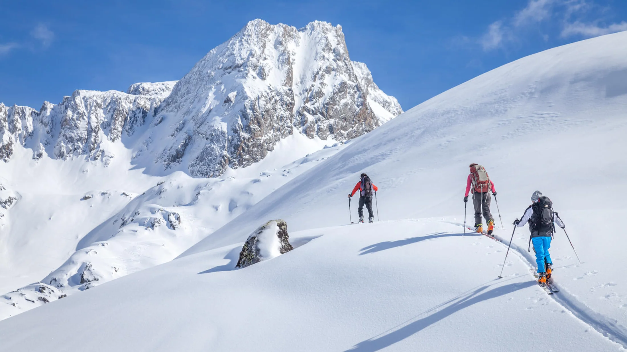
Why the Pyrenees Call for Your Next Ski Tour
Ski touring Pyrenees blends big-mountain feel with village warmth, making it the perfect place to step off-piste safely and learn well. You will find valleys with reliable snow, guarded couloirs, and sunny bowls in Spain, France, and Andorra, all stitched together by historic passes and stone refuges. A faint crunch of skins on morning crust breaks the silence as fir trees release the cold from their needles. This guide highlights seven carefully chosen routes plus planning tools, avalanche safety, and training advice to help you travel smart.
We selected routes using five criteria you can trust:
- Safety potential: terrain that lets you manage risk when conditions allow.
- Accessibility: clear approaches, parking or lifts, and known trailheads.
- Landscape interest: glaciers, cirques, and skyline summits typical of the range.
- Difficulty spectrum: from intro-friendly tours to high-mountain traverses.
- Geographic spread: Central, Aragonese, Catalan, French Pyrenees, Val d’Aran, and Andorra.
Each entry lists approach details, time and elevation gain, technical and fitness demands, best season, specific hazards, suggested gear, and logistics. For verifiable conditions, rely on official avalanche bulletins: Météo-France BRA Pyrénées (France), ICGC Avalanche Bulletin (Catalonia), Centre de Lauegi (Val d’Aran), AEMET Nivology (Aragón/Navarra), and the Andorra avalanche bulletin (Meteo.ad). When in doubt, re-schedule—no slope is worth uncertainty.
Ski mountaineering (ski touring on alpine terrain) means moving uphill with skins and descending on skis, sometimes using crampons and an ice axe on hard snow or short icy steps. If you are new, invest in training before pushing your limit; a one-day intro or a weekend course in avalanche rescue and trip planning builds real competence. You will travel lighter, read terrain better, and enjoy the Pyrenees at your pace. Before you pick a line, check the interactive map in this article, bring the right kit, and remember: turning back is a skill, not a failure.
Picuco te puede ayudar
Does something here catch your eye?
Tell us.
Write to us on WhatsApp or email: we answer questions, find the best options and help you sort out the booking.
How to Read These Route Cards
Use these cards as field-ready notes you can turn into a clean plan and a safe day. Each card opens with a quick description and a single-sentence snapshot of the feel. A ridgeline catching first light is enough image for the day; the rest is practical. Then scan the bullets to confirm fit, season, and logistics before you commit to a tour.
Each card includes:
- Location and access: valley, nearest town, parking, lifts, and any
GR-11or local paths. - Duration and elevation: typical hours, total ascent, and turnaround times.
- Difficulty: technical sections (steepness, crampon/ice axe use) and fitness level.
- Best season: typical window when snow and daylight align.
- Risks: avalanche problems to watch (wind slab, wet loose), cornices, or glacier notes.
- Gear tips: standard ski touring kit plus specific items like harscheisen (ski crampons).
- Logistics: shuttles, refuges, permits if any, and public transport hints.
- Guided options and indicative cost: day rates per group or per person.
Here is how to apply the info:
- Pick a route that matches today’s avalanche forecast and your team’s weakest link.
- Check the interactive map layers for access points, refuge status, and slope angles.
- Reserve a certified guide for complex terrain or if the forecast is level 3 (considerable).
- Confirm last-mile details the evening before: parking rules, lift openings, road closures, and weather timing. A crisp rustle of the weather printout in your pocket can be oddly reassuring.
Seven Outstanding Ski Touring Routes Across the Pyrenees
1) Benasque Valley — Maladeta and Aneto: glaciers and high summits
High Pyrenean light and the blue-shadowed Maladeta Glacier make this a classic traverse with a true alpine tone. You move through high cirques toward Aneto, the Pyrenees’ highest point at 3,404 m, and feel the wind sharpen over the ridge. Expect a big day with glacier complexity and moments on hard, wind-scoured snow.
- Where and access: Huesca (Aragón). Approach from Benasque via Llanos del Hospital to La Renclusa area; check seasonal road closures to La Besurta.
- Duration and elevation: 7–10 hours, 1,400–1,800 m ascent depending on line and detours near
42.632°N, 0.657°E. - Difficulty: Advanced ski mountaineering; secure kick turns, crampon/ice axe use on firm snow, and roped travel knowledge on glacier if crossing crevassed zones.
- Best season: March–May for settled snow and longer days; early season can bring thin bridges and hard ice.
- Risks: Avalanche problems (wind slabs on lee aspects, storm slabs after fresh snow); glacier hazard on Maladeta (crevasses, seracs); cornices near ridges; rapid weather shifts.
- Gear: Crampons, ice axe, harness, rope and crevasse rescue kit for glacier travel; standard DVA/shovel/probe, helmet, harscheisen.
- Logistics: Park at Llanos del Hospital; consider Refugio de La Renclusa for hut-based timing; verify Benasque road status after storms.
- Guided options and price: Certified guide 300–450 € per group/day; larger groups may split costs. Confirm group ratios and glacier equipment.
- Alternatives: Shorter Maladeta-only loop; if winds rise, drop to safer bowls south of the ridge.
Backcountry skiing Pyrenees lines here reward early starts and strict timing; prioritize avalanche safety Pyrenees protocols and turn-around times without hesitation.
2) Tena Valley — Balneario de Panticosa to Collado de Pondiellos: varied tours for mixed abilities
Granite towers and the steam of the old spa set a surreal scene before you slide into quiet basins. Pines sift the sound of your skins as you climb toward Pondiellos. You can dial the day from mellow bowls to sharper cols with excellent snow-catching aspects.
- Where and access: Huesca (Aragón). Drive to Balneario de Panticosa parking; check the A-136/Panticosa access after snowfall.
- Duration and elevation: 3–6 hours, 800–1,200 m ascent for typical tours to Collado de Pondiellos or nearby peaks (Argualas, Garmo Negro variants require more skill).
- Difficulty: Intermediate to advanced; choose terrain to match experience, with steeper options near ridgelines.
- Best season: January–April; cold spells preserve northerly powder, spring brings corn snow.
- Risks: Wind slabs after northerly storms, glide cracks in spring, loaded gullies near Pondiellos; watch for warming on solar aspects.
- Gear: Standard ski touring gear, helmet, DVA/pala/sonda; carry harscheisen for hard mornings and a lightweight ice axe for firm passes.
- Logistics: Ample parking; lifts in nearby Panticosa/Formigal can shorten approaches if combining lift-accessed backcountry skiing Pyrenees laps; no permits required.
- Guided options and price: Local IFMGA guides 260–400 € per group/day; ask for skills refresh or short ski touring courses Pyrenees modules combined with the tour.
- Alternatives: Safer storm day laps in forested lower bowls; advanced teams can link to Ibones de Bachimaña or loop toward Brazato.
Bring material esquí de travesía tuned for variable snow; pick sheltered lines on windy days and keep descent options in mind from the first transition.
3) Vall de Núria / Puigmal: accessible traverses and a strong learning ground
The rack railway hums up the gorge while sunlight flashes over frozen waterfalls and slate roofs. Núria’s amphitheater offers gentle approaches that open to the wide south shoulder of Puigmal. This is a confidence-building place to learn decisions and transitions.
- Where and access: Girona (Catalonia). Reach Núria by rack railway from Ribes de Freser or park at Queralbs; winter access to high trailheads can be restricted to the train.
- Duration and elevation: 4–6 hours, 800–1,000 m ascent to Puigmal (2,910 m) via south or east slopes.
- Difficulty: Ideal for improving beginners to intermediates; straightforward uphill, moderate angles on descent with options to avoid steeper rolls.
- Best season: December–March for cold snow; April for spring corn cycles if freeze–thaw is solid.
- Risks: Wind slab on the crest, whiteouts that kill contrast, and wet loose slides on warm afternoons; watch cornice edges along the ridge.
- Gear: Standard kit (skins, touring bindings, boots); DVA/shovel/probe non-negotiable; pack ski crampons after wind events.
- Logistics: Train schedules make timing simple; Núria facilities provide shelter and hot drinks; confirm if any ski area closures affect access corridors.
- Guided options and price: Group instruction 60–120 € p.p. for a day; private guiding 240–350 € per group/day; ask for courses esquí de travesía modules on avalanche rescue and trip planning.
- Alternatives: Short laps on Núria’s gentler bowls, or link a traverse toward Finestrelles for scenic but manageable mileage.
For Pyrenees ski touring routes that build skills, Núria/ Puigmal lets you practice pacing and avalanche observations without committing to complex glacial terrain.
4) Gavarnie Cirque / Monte Perdido: high mountain grandeur on the weather line
Spindrift sweeps from hanging seracs while the Gavarnie walls glow pale gold in low sun. This is big country straddling France and Spain, with channels, shelves, and cols that demand a precise read on snow and weather. When conditions align, it is unforgettable.
- Where and access: Hautes-Pyrénées (France) / Huesca (Spain). Access from Gavarnie (France) toward Refuge des Sarradets/Breche de Roland or from Torla-Ordesa (Spain) via
GR-11approaches—verify winter restrictions in Ordesa. - Duration and elevation: 6–9 hours, 1,200–1,600 m ascent depending on line to Breche/plateau routes or Monte Perdido sectors.
- Difficulty: Advanced; expect steep sections, potential mixed moves, and exposure; precise navigation in poor visibility is essential.
- Best season: March–May windows; winter cold brings ice and short days, spring stabilizes with corn cycles.
- Risks: Slab avalanches in lee bowls, cornice collapses at the Breche, rapid storms funneling over the divide; hard fall consequences in narrow channels.
- Gear: Helmet, DVA/shovel/probe, harscheisen; light crampons and an ice axe for firm traverses; rope and alpine kit for specific couloirs or if moving on iced sections.
- Logistics: Check hut openings (Sarradets, Góriz) and road access; cross-border weather splits are common—monitor both Météo-France and AEMET forecasts.
- Guided options and price: 320–480 € per group/day; confirm objectives and escape lines in advance, and align on avalanche safety Pyrenees protocols.
- Alternatives: Weather-safe forest laps are limited; if the wind spikes, shift to sheltered valleys or delay the objective.
Esquí de travesía Pirineos here means patience and humility; keep a strict time plan and bail early if clouds cap the cirque.
5) Val d’aran — Baqueira area: lift-assisted backcountry with classic descents
Chairlifts hum, then the sound falls away as you step off the ridge and click skins on. Val d’Aran gathers snow from Atlantic systems, feeding playful bowls and reliable spring corn. Lift-served access lets you sample big terrain with small approaches.
- Where and access: Lleida (Catalonia). Base in Baqueira/Beret; combine lifts with 30–90 minute skin tracks to reach classics like Tuc de Bacivèr or Marimanha basins.
- Duration and elevation: 2–5 hours, 500–1,100 m ascent depending on laps; vertical descent can double if you stack lines via lifts.
- Difficulty: Intermediate to advanced; choose mellow bowls on moderate risk days, save steeper gullies for low-danger windows.
- Best season: December–April; Aranese storms deliver powder, while March–April corn cycles shine on south aspects.
- Risks: Wind slabs under ridges, terrain traps in gullies, and tree-well hazards below treeline; respect closures near resort boundaries.
- Gear: Standard material esquí de travesía plus helmet; radio or phone group comms help in tree zones; carry a small repair kit for lift-access days.
- Logistics: Forfaits needed for lift access; parking plentiful but arrives early on weekends; no special permits beyond resort rules; buses connect Vielha–Baqueira in season.
- Guided options and price: 70–140 € p.p. in groups or 280–420 € per private group/day; guides optimize lift combos and snow quality windows.
- Alternatives: On high hazard days, tour gentle meadows near Beret; advanced teams can step to Montarto from Arties for a wilder feel.
Esquí fuera de pista Pirineos from Baqueira offers efficient sampling of snow types; let the avalanche bulletin and wind history choose your aspects.
6) Comapedrosa (andorra): the country’s highest summit on skis
Cold air slides down Arinsal at dawn as Comapedrosa’s dark pyramid sharpens against the sky. The route is direct and sustained, with honest climbing and a proud summit at 2,942 m. Expect wind effects, quick weather swings, and rewarding views.
- Where and access: Andorra. Start at Arinsal (parking near the resort/Prats Sobirans) and follow the valley toward Refugi de Comapedrosa.
- Duration and elevation: 5–7 hours, 1,300–1,500 m ascent depending on start and snowline.
- Difficulty: Advanced; steady 30–35° slopes with short steeper steps; solid kick turns and crampon confidence required after refreeze.
- Best season: February–April; mid-winter can be icy and wind-hammered, spring offers smoother surfaces.
- Risks: Wind slab (common after NW events), hard fall zones on firm mornings, wet loose after midday thaw; navigation issues in cloud.
- Gear: DVA/shovel/probe, helmet, harscheisen; light crampons and an ice axe strongly recommended.
- Logistics: Easy access from Arinsal; check resort operations for parking guidance; no permits required; consider hut timing for weather buffers.
- Guided options and price: 300–450 € per group/day; ask about short ski touring courses Pyrenees add-ons (kick turns on steep skin tracks, safe transitions in wind).
- Alternatives: If slabs build, choose lower-angle meadows toward Pla de l’Estany or postpone for a firmer refreeze.
For a committed yet achievable peak, Comapedrosa rewards early starts, strict avalanche observations, and smooth pacing on the climb.
7) Pic du Midi d’ossau — Vallée d’ossau: an emblem of the French Pyrenees
Morning alpenglow washes the volcanic plug of Ossau, and you hear only the soft rasp of skins on old snow. Rounded basins give way to sharper passes and short, exposed traverses. The mountain’s presence is constant—and magnificent.
- Where and access: Pyrénées-Atlantiques (France). Access from Laruns; common winter trailheads near Col du Portalet or Caillou de Soques;
42.873°N, -0.442°E. - Duration and elevation: 5–8 hours, 1,000–1,400 m ascent for classic circuits around Pombie/Peyreget sectors.
- Difficulty: Intermediate to advanced; some passages exposed or with no-fall consequences; stable technique required.
- Best season: January–April; mid-winter cold holds powder in shaded bowls, spring corn shines on south flanks.
- Risks: Cornices along ridges, wind slabs below the crest, firm morning traverses; sudden fog banks after fronts.
- Gear: Helmet, DVA/shovel/probe; harscheisen, light crampons, ice axe for firm sidehills; a short rope can calm exposed moves for mixed-ability teams.
- Logistics: Check access and parking near Portalet (border weather can flip quickly); Pombie hut status varies—confirm if you plan early starts nearby.
- Guided options and price: 280–420 € per group/day; insist on a clear risk plan and communication protocol (radios/phone).
- Alternatives: Softer day to Col de l’Iou bowls in unstable weather; confident teams can link to Peyreget for a longer tour.
Ski touring Pyrenees days around Ossau feel wild yet close to the road; match your loop to the avalanche danger and keep escape routes live all day.
Interactive Map and Access: Your Planning Companion
Use the interactive map embedded in this article to turn ideas into a line you can actually ski. It layers relief shading, slope angles, pistes (to understand closures and boundaries), refuges, trailheads, and avalanche bulletins or radar overlays where available. As you zoom, you will see the terrain grain sharpen, like frost tracing a windowpane. The map works online on desktop and mobile; download offline tiles before you lose coverage in deep valleys.
How to get value from the map:
- Turn on slope angle shading and avoid sustained 30–45° slopes on considerable or higher danger days.
- Toggle refuge and access layers to plan hut-based starts (La Renclusa, Pombie, Comapedrosa) and confirm road status to winter gates.
- Add waypoints to critical decision points: the last safe meadow, the start of a convex roll, and the planned high point.
- Import GPX tracks for reference, but never follow a line blindly; cross-check with today’s avalanche forecast and recent wind direction.
- Use the piste layer to plan lift-accessed exits in Val d’Aran and to respect closures.
- Mark safe regroup spots out of runout zones for transitions and breaks.
Before leaving home, confirm:
- Avalanche danger level and specific problems (wind slab, persistent weak layers, wet loose) from official bulletins for your sub-region.
- Weather timing (wind, snowfall, freezing level), plus visibility windows for navigation.
- Road and lift status, refuge openings, and any park advisories (Ordesa, Portalet).
On mobile, keep your track recording light to save battery; a paper map and a simple compass back up your phone if it dies. For mountain rescue, save local emergency numbers in your phone and as a write-up inside your first-aid kit. A cold breeze on your face at the trailhead will remind you why redundancy matters.
Choosing Routes, Gear, and Training That Fit You
Start with the team you actually have, not the team you wish you had. Match the route to the lowest experience level, the day’s avalanche danger, and the weather’s rhythm. Picture the snow surface under your skis—breakable crust, cold powder, or spring corn—and choose aspects that make that surface work for you.
A simple route filter:
- Fitness: If 800 m ascent takes you 4–5 hours, pick sub-1,000 m tours until transitions feel smooth.
- Technique: If jump turns are shaky, keep descents under 35° and avoid narrow gullies.
- Conditions: With considerable danger (level 3), favor low-angle meadows and well-supported slopes; save big ridges for level 1–2.
Essential ski touring gear Pyrenees checklist:
- Skis with touring bindings, skins trimmed well, and ski crampons (harscheisen).
- Boots that walk efficiently; check cuff range and fit with your socks.
- Poles with reliable locks; a repair kit (multi-tool, screws, strap, spare tip).
- DVA/shovel/probe, helmet, and a slim first-aid kit plus bivy/survival blanket.
- Crampons and a light ice axe for firm mornings or if your route crosses hard snow.
- Layers: wicking base, insulating mid, windproof shell; two pairs of gloves.
Fit and test:
- Practice transitions at home: skins on/off, crampons on boots, modes on bindings.
- Adjust binding release values with a technician; test at a resort morning before a tour.
- Do a parking-lot DVA check before stepping off.
When to hire a guide or take ski touring courses Pyrenees:
- New to touring, uncertain about avalanche rescue, or stepping into glaciated/high-mountain terrain.
- Complex weather/avalanche setup or when you want to learn route-finding and snowpack tests.
- Expect 60–140 € p.p. for group courses or 280–480 € per private group/day; confirm IFMGA/UIAGM certification, local experience, insurance, ratios, and contingency plans.
Training links directly to avalanche safety Pyrenees outcomes: you will identify traps sooner, read wind patterns faster, and choose mellow exits instead of forced lines. A single, clean drill under stress can save minutes that matter.
Mountain Safety and Avalanches: Protocols and Real Practice
Avalanches result from a weak layer in the snowpack failing under load on a slope steep enough to slide—usually 30–45°. Problems you will see in the Pyrenees include wind slab (dense snow deposited on leeward slopes), storm slab (new snow without strong bonding), persistent weak layers (facets or depth hoar), and wet loose or wet slab in spring. Winds carve texture like corduroy on ridges; read it to guess where slabs likely formed.
Key habits:
- Read the local bulletin: Météo-France BRA Pyrénées (France), ICGC bulletin (Catalonia), Centre de Lauegi (Val d’Aran), AEMET (Aragón/Navarra), and Andorra BPA. Focus on danger level by elevation and aspect, avalanche problems, and recent events.
- Plan conservative terrain on level 3 (considerable) or higher; save 35–40° slopes for level 1–2 with a supportive snowpack.
- Space out on suspect slopes; regroup out of runouts; keep eyes on partners in exposed zones.
DVA/shovel/probe practice:
- Group check at the trailhead: everyone transmits and receives.
- In a burial: switch to search, follow signal to coarse/fine search, then pinpoint with probe in a spiral grid.
- Shovel fast and low, downhill of the probe strike; move snow away in conveyor style with partners.
Emergency protocol:
- Shout and observe the last seen point; mark it.
- If safe, one rescuer leads search; others watch hangfire and call rescue.
- Call emergency services early with location, number buried, and injuries; keep one phone open for updates.
- If secondary avalanches threaten, re-evaluate; your safety comes first.
Pre-departure checklist:
- Weather, avalanche bulletin, route plan with alternatives and turn-around time.
- DVA battery >60%, probe locks, shovel intact, helmet packed.
- First-aid, repair kit, headlamp, map/compass, charged phone plus power bank.
Practice matters: do monthly beacon drills, dig snow pits to learn layers, and run simulated scenarios with time limits. Integrating safety into routine makes it easier to choose a quiet bowl over a risky face when clouds stack on the ridge.
Frequently Asked Questions
What skill level do I need to start ski touring?
If you can link controlled parallel turns on red runs and manage variable snow, you can begin on mellow 25–30° tours like Núria bowls. Start with 600–800 m ascent days and build pacing, transitions, and navigation before steeper terrain.
How do I choose the right equipment?
Pick skis 85–95 mm underfoot for versatility, light but supportive boots, reliable pin bindings, and skins that glide and grip. Add DVA/shovel/probe and a helmet, then test everything on a short tour or resort morning to dial fit and transitions.
When should I hire a guide?
Bring a guide if the avalanche danger is considerable, the route includes glaciers or exposed traverses, or your group lacks rescue practice. Expect 280–480 € per private group/day; confirm certifications, local knowledge, and ratios.
Do I need permits or special documents?
Most Pyrenees valleys don’t require permits for day touring, but some parks manage winter access and hut bookings. Check local rules around resort boundaries (Baqueira) and road closures (Ordesa, Portalet) before you go.
How do I read the avalanche forecast?
Focus on danger level by elevation and aspect, the named avalanche problems, and recent wind/snow history. Match your terrain to the weakest link in the group and choose slopes under 30° when the bulletin flags wind slabs or persistent weak layers.
Where can I take courses?
Look for certified providers offering avalanche rescue and trip-planning modules across Aragón, Catalonia, Val d’Aran, and Andorra. Group days (60–140 € p.p.) or private instruction let you practice beacon drills, route finding, and snowpack tests on real tours.
Book your experience — discover verified active-travel providers across Spain with Picuco.
Conclusion
These seven routes show the breadth of ski touring Pyrenees terrain, from accessible bowls in Núria to the glaciated shoulders of Maladeta and the proud skyline of Ossau. Each valley carries its own rhythm, kept alive by refuges, local guides, and the communities that open winter roads and share forecasts. The faint hiss of skis on spring corn is sweeter when your plan is sound.
Carry the right gear, read the avalanche bulletin, and choose terrain that fits both the day and your team. If you want a head start, reserve a course or a certified guide and use our interactive map to shape a conservative, rewarding line. Share this guide with your partners, leave a comment with your experiences, and subscribe for seasonal snow updates so your next decision in the mountains comes easier.