What Do We Mean by Spain’s Nature “records”?
Spain’s landscapes hold extremes that spark curiosity and invite careful travel. Here, “records” means the highest, the deepest, the tallest, the oldest or the largest features that nature has shaped across the peninsula and islands. Think of the highest mountain in Spain rising from the Atlantic, or a waterfall that appears like a silver thread after winter rains.
These milestones matter to hikers, photographers, families, and researchers because they combine scientific interest with cultural meaning and real travel decisions. We rely on measured data and broad consensus from park authorities, scientific teams and cartographic institutes, while noting that discoveries can shift rankings. You’ll find records spread from the Canary Islands to Galicia, from the Pyrenees to inland plateaus, each with its own season, safety notes and access patterns.
You’ll get clear facts, a sense of place, and practical steps to experience these extremes respectfully and at your own pace.
How records are measured across peaks, caves, canyons, trees and lakes
We measure altitude above sea level for summits, depth below the entrance for caves, vertical drop for waterfalls, relative relief for canyons (rim-to-river height), and area and origin for lakes and lagoons. The highest mountain in Spain is measured to its summit above mean sea level, not from the ocean floor, while the depth of a cave is the vertical difference between the highest entrance and the lowest explored point. Picture an altimeter, a rope, a rangefinder and a GPS working together under changing skies.
Spain’s “national” records include island territories, while “peninsular” records exclude the archipelagos; you’ll see both where relevant. For example, Teide (Tenerife) is Spain’s summit record, and Mulhacén (Sierra Nevada) is the peninsular high point. Waterfalls can be perennial or seasonal; the tallest free-fall may only roar after heavy rain. Lakes are often clarified by type: glacial lakes differ from coastal lagoons. These distinctions help you plan realistic expectations on the ground.
What you’ll take away from this guide
- The exact sites that hold Spain’s main natural records and why they matter.
- Best seasons to go, with weather, water flow and daylight in mind.
- How to get there: nearest airports, trains, roads and last-mile trailheads.
- Where to stay nearby, from campsites and huts to rural guesthouses and small hotels.
- Simple activity ideas for each place plus essential safety checks.
- Two bonuses: suggested itineraries connecting several records and an FAQ for quick decisions.
Picuco te puede ayudar
Does something here catch your eye?
Tell us.
Write to us on WhatsApp or email: we answer questions, find the best options and help you sort out the booking.
Spain’s Extremes at a Glance
If you want the quick answers, start here, then dive deeper into details below. Imagine tracing these records on a map like beads on a necklace, each glowing in a different season.
| Record | Place | Region | Key figures | Why it stands out | Visiting notes |
|---|---|---|---|---|---|
| Highest mountain | Teide | Tenerife, Canary Islands | 3,715 m a.s.l. | Stratovolcano and Spain’s roof; UNESCO World Heritage (2007) | Cable car to 3,555 m; summit path with permit; alpine conditions in winter |
| Deepest cave | Torca del Cerro del Cuevón – Sistema del Jitu | Picos de Europa, Asturias | −1,589 m (depth) | Landmark of European alpine karst exploration | Not for the general public; technical caving only, with SRT gear and permits where required |
| Oldest tree (contested by method) | Farga I Olive of Ulldecona; also Bermiego Yew (Asturias) as cultural icon | Tarragona (Catalonia); Asturias | c. 1,700–2,000+ years (olive, radiocarbon/dendro cross-checks); yew often cited 1,000–1,500+ years | Living links to rural farming and sacred groves | Access usually easy; be respectful of barriers/roots; guided visits common in olive groves |
| Tallest waterfall (free-fall) | Salto del Nervión | Border of Burgos (Castile and León) and Álava (Basque Country) | 222 m | Spain’s tallest single-drop fall, often ephemeral | Best after winter/spring rains; family-friendly tracks from Monte Santiago or Délica |
| Deepest canyon (river relief, widely cited) | Sil River Canyon (Cañón do Sil) | Ribeira Sacra, Galicia | Up to ~500 m rim-to-water | Terraced vineyards on near-vertical slopes; dramatic granitic gorge | Miradouros by road; boat trips in-season; great autumn light |
| Largest natural lake (glacial type) | Lake Sanabria | Zamora, Castile and León | ~3.48 km², max depth ~51 m | Iberia’s largest glacial lake within a protected park | Signed beaches, trails, limited boating; best late spring–early autumn |
Notes you’ll see later: some titles depend on definitions. For lakes, coastal lagoons like Albufera de València are larger but are brackish lagoons; for “largest glacial lake”, Sanabria is clear. For “oldest tree”, the olive of Ulldecona has robust dating; yews like Bermiego carry deep cultural weight and likely exceed a millennium.
Spain’s Nature Records in Detail
1.Teide, Tenerife: Spain’s Highest Mountain and a Living Volcano
Teide rises to 3,715 m a.s.l. above Tenerife, making it unequivocally the highest mountain in Spain and the third-tallest volcanic structure on Earth when measured from the ocean floor. Above the sea of clouds, pumice and black lava glint under high sun. You move from coastal spring to alpine winter in a single day, so pack layers and respect altitude.
This stratovolcano crowns Teide National Park (UNESCO World Heritage since 2007), with the cable car reaching La Rambleta at 3,555 m and the short Telesforo Bravo path to the true summit requiring a free permit managed by the National Park. Expect sub-zero windchill and occasional snow from December to March; ideal hiking windows are late spring and September–November. Practical tips: check cable car operations day-of, carry 2–3 L water per person, and book summit permits weeks ahead. If you prefer long traverses, the GR-131 crosses Tenerife and offers lava-field walking, observatory views and starry night skies from high refuges.
2.Torca del Cerro del Cuevón – Sistema del Jitu: Spain’s Deepest Cave
The cave system known as Torca del Cerro del Cuevón – Sistema del Jitu in the Picos de Europa (Asturias) holds Spain’s depth record at approximately −1,589 m from entrance to lowest explored point. Imagine a beam of headlamp dissolving into cold blackness while rope hums through your descender. This is alpine karst at its most demanding.
By type, it’s a multi-entrance alpine karst system with shafts (simas) and meanders shaped by water over geologic time. It is not open to casual visitors: access entails advanced single-rope technique (SRT), rigging expertise, flood awareness and expedition logistics; some areas may require coordination with local clubs or park managers. Public-friendly alternatives exist in other show caves across northern Spain, but the cueva más profunda de España remains an expert realm. If you are an active speleologist, verify topos, rigging updates and weather; if not, consider introductory caving with certified guides in safer, designated systems you can find through Picuco.
3.The Oldest Tree: Ancient Olive of Ulldecona and the Living Heritage of Spain’s Yews
Spain’s oldest living tree, by the strongest scientific dating, is widely attributed to the Farga I olive of Ulldecona (Tarragona), with radiocarbon and dendrochronological cross-checks placing it around 1,700–2,000+ years old. The silver underside of its leaves flickers like fish scales in the breeze. This survivor grew with Roman-era farmers and still anchors local identity.
Elsewhere, venerable yews (Taxus baccata) such as the Bermiego Yew (Asturias) likely exceed a millennium and serve as sacred trees near chapels, though exact ages can be harder to confirm due to hollow cores. The árbol más viejo de España comes with two rules: don’t step on roots or cross protective fencing, and avoid touching bark or low branches. Many olive groves offer guided visits and interpretation; check community-managed schedules and follow any signage. Responsible viewing ensures that future generations can stand in the same dappled shade.
4.Salto del Nervión: Spain’s Tallest Waterfall and Its Elusive Flow
The Salto del Nervión plunges in a free fall of about 222 m at the border of Burgos and Álava, making it the tallest waterfall in Spain by single-drop height. On good days it threads the air like a white silk ribbon against dark limestone. Yet its star quality is seasonal, as the flow depends on winter snow and heavy rains.
You can approach from Monte Santiago (Burgos) or from Délica (Álava) on signed tracks that range roughly 2–7 km round trip, suitable for families in stable weather. The best viewing months are typically late winter to spring (January–April), and after Atlantic storms; summers are often dry and the fall may vanish. Miradores with railings sit near cliff edges—keep children close, avoid gusty days, and stay behind barriers. Photographers should arrive early for soft light; walkers can extend to nearby viewpoints over the canyon rim for wider perspectives.
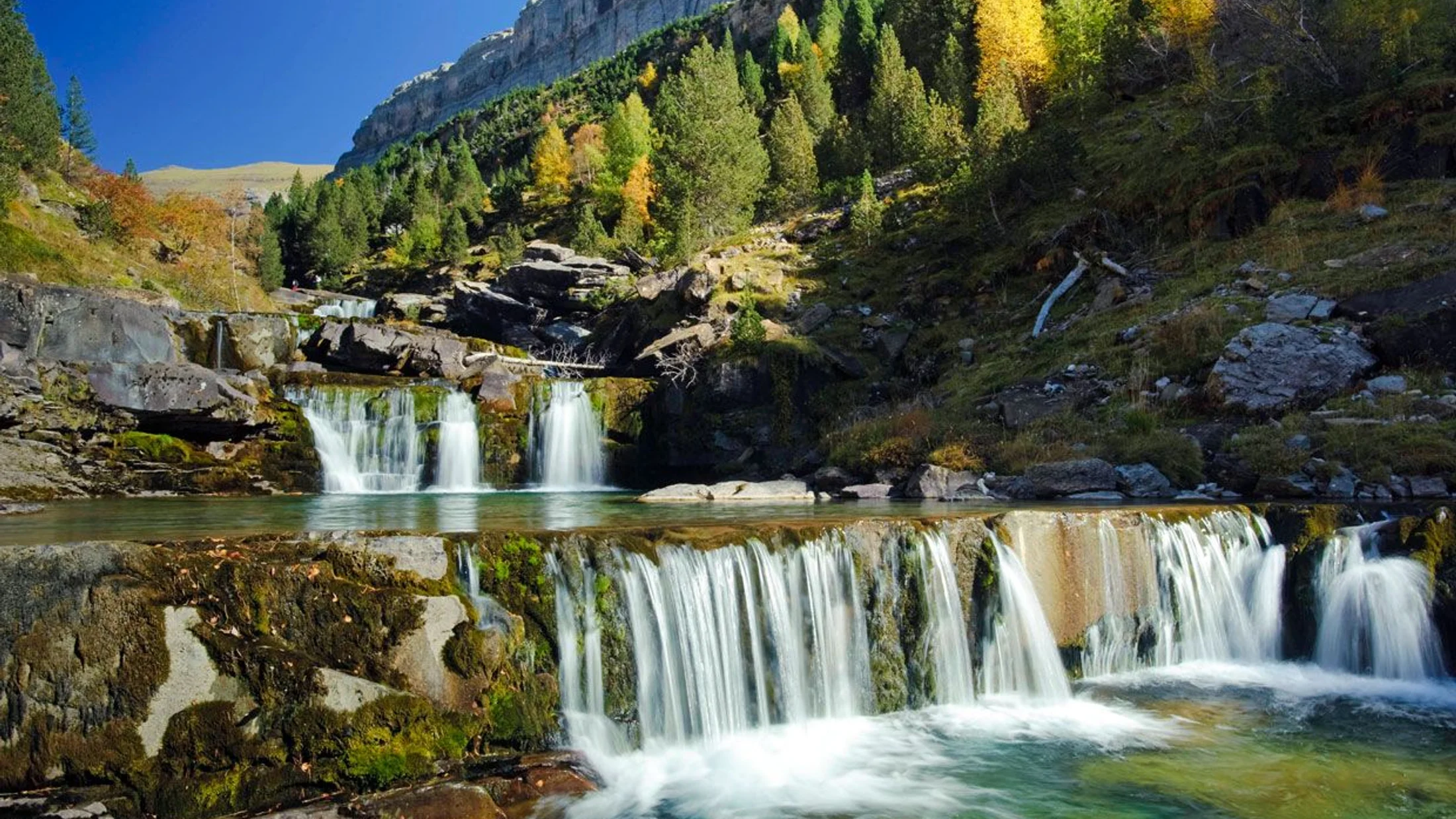
5.Sil River Canyon: Spain’s Deepest River Gorge by Common Reference
Carved into granite and schist, the Sil River Canyon (Cañón do Sil) in Galicia drops up to roughly 500 m from rim to water, and is commonly cited as the cañón más profundo de España for river-relief depth. Autumn paints the vineyard terraces like a mosaic of copper and gold. Here, geology, viticulture and viewpoint roads combine into a landscape easy to access yet grand in scale.
You’ll find stellar miradouros like Os Balcóns de Madrid, Cabezoás and Cividade along both banks; allow a day to hop viewpoints and another for a boat trip (seasonal) through the narrowest stretch. Technical activities exist elsewhere in Galicia, but the Sil itself is more about scenic drives, boat tours, and moderate hikes on stepped trails among terraced vines. Note: some Pyrenean gorges display larger absolute wall heights in places, but they are broader glacial–karst valleys; for a river-incised canyon with road-accessible rims and sustained depth, the Sil remains Spain’s reference point.
6.Lake Sanabria: Spain’s Largest Natural Glacial Lake
Lake Sanabria in Zamora is the largest natural glacial lake on the Iberian Peninsula, covering about 3.48 km² with depths around 51 m in Sanabria Lake Natural Park. In June, the water lies clear as glass beneath cirques scarred by ancient ice. Its bays, beaches and granite headlands make it equally inviting to families and hikers.
Access is straightforward via Puebla de Sanabria, a hilltop town with services and rail/bus links. Designated swimming areas and small craft rentals operate in season; electric boats and kayaks are common, while powered craft are restricted to protect the shoreline. Trails loop to viewpoints and glacial benches; in hot spells, start early to avoid crowds. While some larger coastal lagoons exist in Spain, the largest lake in Spain by glacial, inland origin is Sanabria—an ideal base to pair with the Ribeira Sacra or northern mountains.
Where and When to Go: Matching Regions and Seasons
Spain’s records live in distinct climate zones, so timing is everything. Imagine a calendar where Atlantic fronts sweep the north as trade winds cool high volcanic slopes in the Canaries. Good planning means meeting each place at its best.
-
Canary Islands (Teide, Tenerife):
- Best months for the highest mountain in Spain: late spring (May–June) and early autumn (September–November) for stable weather and fewer queues.
- Winter (Dec–Mar) can bring snow and ice at altitude; the cable car may close due to wind. Summer (Jul–Aug) is hot at sea level and busy on trails.
- Star-gazing is exceptional year-round at high elevations; pack layers and sun protection regardless of season.
-
Northern interior and Atlantic edge (Nervión, Picos de Europa, Sil Canyon, Sanabria):
- Salto del Nervión: plan for late winter to spring, and after major rains; avoid summer if your goal is the waterfall itself.
- Picos de Europa (deep cave region): spring to autumn is best for hiking, but caves demand year-round technical caution and flood awareness; never enter technical systems in forecasted heavy rain.
- Sil River Canyon: spring and autumn shine with cool temperatures and vineyard colors. Boat services are seasonal (typically spring–autumn), and some viewpoints can be windy any time.
- Lake Sanabria: late spring through early autumn offers swimmable water and open facilities; in shoulder seasons, enjoy quieter trails and cooler air.
-
Peninsular high mountains (Mulhacén context, if you’re comparing):
- For context, Mulhacén (3,479 m) in Sierra Nevada, the peninsular high point, is typically best June–October outside snow periods, with strict winter hazards. This matters if you’re choosing between Canary and mainland high summits.
Season-specific considerations:
- Snow and ice: Teide and peninsular peaks may require microspikes, winter boots, or even crampons/axe—check conditions and be conservative.
- Water flow: Nervión’s height is constant but its water is not; recent rainfall makes or breaks your visit.
- Access closures: High winds can shut Teide’s cable car; storm damage can close northern trails or roads.
- Daylight: Northern Spain has long summer days for canyon drives, but hot midday hours at Sanabria are best avoided.
If you want a safe bet for first-timers: plan Teide between late spring and early autumn with a pre-booked summit permit; pair Sanabria and the Sil Canyon in September–October for comfortable hikes and vibrant slopes; and save Nervión for a flexible winter–spring window when Atlantic systems arrive.
Getting to Spain’s Records: Planes, Ferries, Roads and Trailheads
Every record has a “big-picture” access path and a final on-foot approach. Picture a simple chain: flight or long-distance train, a car ride on regional roads, then a signed path under open sky.
Main transport: plane, ferry and car
-
Teide and Tenerife:
- Fly to Tenerife North (TFN) or Tenerife South (TFS) from major Spanish and European airports; drive ~1–1.5 hours to Teide National Park via TF-21 or TF-24.
- Ferries connect Tenerife with other Canary Islands; this matters if you’re stacking island hikes in one trip.
- Because trailheads are dispersed and summit windows depend on forecasts, renting a car offers the most flexibility for the highest mountain in Spain; public buses reach certain points but schedules can be limiting.
-
Northern mainland hubs:
- Nervión: Vitoria-Gasteiz or Bilbao airports are closest; drive 45–90 minutes to Monte Santiago (Burgos) or Délica (Álava).
- Sil Canyon: Santiago de Compostela, Vigo or A Coruña airports feed Galicia; Ourense city is a good rail hub before you drive into Ribeira Sacra.
- Lake Sanabria: reach Puebla de Sanabria by A-52 from Benavente; nearest airports include Valladolid and Vigo; long-distance trains stop at Puebla de Sanabria AV.
- Caving zones in Picos de Europa: Oviedo/Asturias or Santander airports; mountain roads lead to villages near karst entrances.
Renting a car is usually best for canyons, lakes and mixed rural stops; use public transport for city segments and pick up a car just before mountain days.
Local transport and trails to the record points
-
Trailheads and parking:
- Teide: parking lots at cable car base and viewpoints fill early; arrive before 9:00 or late afternoon. Summit path from La Rambleta requires permit and timed entry.
- Nervión: Monte Santiago (Burgos) offers signed tracks on mostly flat terrain; Délica side in Álava adds dramatic canyon-floor views.
- Sil Canyon: roads on both banks reach miradouros; expect narrow bends and short walks of 5–20 minutes to platforms.
- Sanabria: lakeside parking areas lead to signed beaches and trails; ridge paths climb to glacial cirques for broader views.
-
On-foot effort and tools:
- Short family walks: Nervión viewpoints (2–7 km RT), many Sil Canyon platforms (under 2 km RT), Sanabria lakeside strolls (1–5 km).
- Moderate hikes: Teide lava loops below cable car (5–10 km, high altitude); Sanabria ridge trails (8–16 km with elevation).
- Navigation: download offline maps, carry paper backups for longer hikes, and use Spain’s national
IGNcartography app or GPX files from official park sources.
Technical access: caves, canyons and seasonal hazards
-
Caves:
- The cueva más profunda de España is a technical expedition only. Do not attempt without training, SRT gear, team planning, and authorization where needed. Flood pulses are lethal—never enter with rain forecast.
- For non-technical experiences, choose designated show caves or guided “intro to caving” outings listed by certified operators; avoid unguided entry to wild caves.
-
Canyons and waterfalls:
- At Nervión, keep well behind railings and avoid cliff-edge selfies on windy days. Path edges can be slippery in frost or after rain.
- Technical canyoning requires a guide, specific gear (wetsuit in cold waters, harness, descenders) and flow-aware decision-making; choose routes and providers through Picuco to match your level.
-
Permits and closures:
- Teide summit permits are quota-limited and free; book weeks in advance. The park may close trails or the cable car due to wind, ice or maintenance.
- Some miradouros and rural roads temporarily close after storms or for fire-risk prevention in summer; always check local advisories.
Where to Sleep and Find Services Near the Record Sites
To enjoy dawn light, you’ll want to sleep nearby. Picture a rural breakfast as mist rises from a lake or vineyard terraces glow with first sun. Proximity balances comfort with calm mornings and safer timing.
Stays by budget and proximity
-
Budget-friendly:
- Campgrounds near Sanabria and in Galicia’s interior open seasonally; basic bungalows offer shelter in shoulder seasons.
- Simple hostales and albergues in towns like Puebla de Sanabria or Ourense keep costs low and access easy.
-
Mid-range:
- Rural guesthouses and casas rurales in Ribeira Sacra place you near viewpoints while offering home-cooked dinners.
- On Tenerife, small hotels in La Orotava or Vilaflor cut commute time to Teide’s high roads and trailheads.
-
Splurge or special stays:
- Vineyard lodges in the Sil Canyon area give sunset terraces and quick dawn drives to miradouros.
- Charming historical stays in hill towns add character between early starts.
Advantages of staying close:
- Beat parking pressure and crowds at Teide cable car and Nervión miradores.
- Catch the best light at canyons and lakes.
- Have flexible weather windows for the highest mountain in Spain and seasonal waterfalls.
Reserve early for weekends and holidays, and consider shoulder-season nights to enjoy quieter trails.
Essential services: guides, gear and emergencies
-
Local guides and rentals:
- For introductory caving, canyoning, lake kayaking or guided summit days, hire certified professionals; you can compare options on Picuco and match difficulty, group size and season.
- Mountain gear rentals exist in larger towns near each area; book ahead in peak months.
-
Visitor centers and information:
- National and natural parks host information points with maps, safety notes and seasonal alerts; stop in on arrival days.
- Rural tourism offices can confirm road works, boat schedules and local events.
-
Emergencies and insurance:
- Dial 112 anywhere in Spain for emergencies.
- Carry ID, note your accommodation address, and share your route plan.
- Consider travel insurance that covers mountain and adventure sports; many policies require guided outings for coverage in technical terrain.
- For specialized trips like caving or canyoning, confirm in writing what your guide or operator includes (gear, permits, liability insurance).
Three Itineraries to Connect Spain’s Natural Records
Linking records can be simple or ambitious. Imagine three arcs: a weekend sampler in the northwest, a mid-length blend of water and mountains, and a week-plus circuit that adds the Canary crown.
1) Weekend sampler: Sil Canyon and Lake Sanabria
-
Base and flow:
- Fly or train to Ourense or Puebla de Sanabria on Friday evening. Pick up a rental car if needed.
- Saturday: explore the Sil Canyon. Drive the north-bank road to miradouros like Cabezoás, then cross to Os Balcóns de Madrid on the south bank. Short walks (5–20 minutes each) make this family-friendly.
- Sunday: Lake Sanabria. Swim in season at designated beaches or paddle by kayak in the morning; hike an 8–12 km ridge loop for glacial views before traveling back.
-
Times and distances:
- Ourense to central Ribeira Sacra viewpoints: 45–60 minutes.
- Ribeira Sacra to Puebla de Sanabria: around 1.5–2.5 hours by car depending on route.
-
Where to sleep:
- Night 1 in Ribeira Sacra for sunrise at viewpoints.
- Night 2 in Puebla de Sanabria to be at the lake early.
-
Contingencies:
- If rain sets in, trim the viewpoint circuit and focus on lower, forested trails and heritage towns. Keep day-two lakeside activities flexible for wind.
2) 3–5 days of water and rock: Nervión plus Picos foothills
-
Day-by-day:
- Day 1: arrive in Vitoria-Gasteiz or Bilbao; drive 45–90 minutes to Monte Santiago. Sunset scout of the plateau above Salto del Nervión (keep to barriers).
- Day 2: morning return after rain/snow for best waterfall chances; add Délica canyon-floor walk if conditions allow. Afternoon drive to the eastern Picos de Europa foothills.
- Day 3–4: base in a mountain town (e.g., near the Cabrales area). Hike well-signed valley trails with limestone walls and pastures; join an introductory cave walk in a designated, guided setting if interested.
- Day 5 (optional): cultural day in coastal Cantabria or return flight.
-
Logistics:
- Daily driving legs are 1–3 hours; road access is straightforward but winding near the mountains.
- The cueva más profunda de España is not a tourist visit—choose guided, non-technical caves through certified providers for a safe taste of the karst world.
-
Weather plan:
- Keep Nervión flexible around rain. If the fall is dry, the plateau and canyon rim are still dramatic.
3) 7+ days “great Records” route: Mainland gems and the Canary summit
-
Route concept:
- Days 1–2: arrive in Madrid or Valladolid; drive to Puebla de Sanabria. Explore Lake Sanabria’s trails and quiet bays.
- Days 3–4: continue to Ribeira Sacra (Ourense). Combine 6–8 miradouros and a boat tour (in season) for the Sil Canyon.
- Day 5: drive or train to Vitoria-Gasteiz; quick transfer to Monte Santiago for the Nervión plateau at golden hour.
- Day 6: reserve morning for the waterfall (post-rain if lucky), then return to Bilbao or Madrid for an evening flight to Tenerife.
- Days 7–8: Teide focus. Pick up a car; scout high viewpoints on TF-21/TF-24; ride the cable car if running; summit with a pre-booked permit and fair forecast. Add a night-sky session.
-
Effort and buffers:
- Keep half-days open for weather at Nervión and Teide; build in rest after flights and high-altitude days.
- Optional additions: a coastal walk in Tenerife’s Anaga forests or Teno cliffs; a vineyard visit in Ribeira Sacra.
-
Variants:
- Mainland-only version: swap Teide for a Sierra Nevada hike (Mulhacén area in season), noting it’s the peninsular high point, not the national record.
Practical Safety for Mountains, Caves, Forests, Lakes and Falls
Great records can tempt rushed decisions. Picture a simple checklist in your pocket as clouds gather or a river runs high. Clear boundaries keep wild places inspiring and you, safe.
-
Mountain and high-altitude tips (Teide, high ridges):
- Acclimatize: above 3,000 m, ascend slowly, hydrate, and watch for headache or nausea; descend if symptoms worsen.
- Gear up: windproof layers, hat, gloves, sunglasses, sunscreen, and 2–3 L water per person.
- Forecast first: wind shuts cable cars; winter brings ice. Carry a headlamp, map/compass, and offline navigation on your phone.
- Permits: for Teide’s summit path, secure the permit in advance and bring ID matching your reservation.
-
Caves (technical environments):
- No entry to wild caves without training, proper SRT equipment, a competent team and clear weather windows.
- Flood risk is real: avoid after rains; note that underground water levels can rise faster than expected.
- Choose guided, public-friendly caves if you’re new; never go solo.
-
Forests, lakes and canyons (Sanabria, Sil, Nervión):
- Slips and edges: canyon rims and wet rocks are unforgiving; keep children close and respect barriers.
- Watercraft: wear PFDs for any boating; obey zoning and speed limits; check wind before launching.
- Heat and exposure: even in Galicia, summer sun burns; carry water and start early.
- Wildlife and flora: do not feed animals; stay on trails to protect habitats and roots, especially near ancient trees.
-
Leave No Trace principles:
- Pack out all trash, including tissues and food waste.
- Stay on established paths; avoid shortcutting switchbacks.
- Keep noise low; drones are often restricted in protected areas—check rules.
- Buy locally and thank the people who maintain trails, vineyards and groves—your euros help landscapes thrive.
-
Insurance and guides:
- Verify that your travel insurance covers mountain sports and guided activities; some require helmet use or certified guides.
- For canyoning, caving or summit routes, pick certified professionals and confirm what’s included: gear, permits, and emergency plans.
Frequently Asked Questions
What is the highest mountain in Spain and how does it differ from the highest peak on the peninsula?
Spain’s highest mountain is Teide (3,715 m) on Tenerife in the Canary Islands, a stratovolcano within Teide National Park (UNESCO). The highest peak on the Iberian Peninsula is Mulhacén (3,479 m) in Sierra Nevada. Teide’s volcanic terrain, altitude and island climate mean rapid weather shifts; winter can bring ice and cable car closures, and the summit trail needs a pre-booked permit. Mulhacén has alpine hazards too, but no summit permit; winter ascents demand full mountaineering gear. For first-timers, Teide’s cable car offers quick high-altitude access if winds allow, while Mulhacén typically requires a longer, sustained hike. Choose based on season, fitness, and whether you want a volcanic island environment or mainland alpine scenery.
Can I visit all the caves and canyons mentioned without a guide?
No. The cueva más profunda de España—Torca del Cerro del Cuevón – Sistema del Jitu—is an advanced, technical system requiring SRT skills, team experience, and strict flood awareness; it is not suited to general tourism. Instead, opt for designated show caves or guided introductory trips with certified professionals, which are widely available in northern Spain. For canyons and waterfalls, many viewpoints and trails are public and family-friendly (e.g., Salto del Nervión miradores), but technical canyon descents can require ropes, wetsuits, and expert judgment. When in doubt, hire a qualified guide, check local regulations, and never enter wild caves or attempt canyon descents after heavy rain or with improvised gear.
When is the best time to see waterfalls and lakes at their peak?
For waterfalls, late winter to spring is generally best, and Salto del Nervión specifically needs recent rain or snowmelt to flow—dry summers often leave it silent. Lakes like Sanabria are most enjoyable from late spring through early autumn for swimming and boating, while autumn brings quieter shores and golden light for photography. Microclimates matter: Atlantic fronts keep northern Spain (Galicia, Basque Country) wetter and greener, whereas inland summers can be hot. Always check recent rainfall before waterfall trips and local advisories for lake conditions; if you aim for vibrant vineyard colors in the Sil Canyon, target late September to mid-October.
Book your experience — discover active nature experiences in Spain with providers verified by Picuco.
Conclusion
Spain’s natural records invite you to meet the land where it is highest, deepest, oldest and most dramatic. From the highest mountain in Spain on Tenerife to the fleeting roar of Salto del Nervión, from ancient olive groves to granite gorges and clear glacial water, each site blends science, culture and community stewardship. Think of park rangers, trail crews, vineyard families and rural hosts who keep these places alive for visitors and neighbors alike.
Use this guide to match seasons and places: Teide in late spring or early autumn, Nervión after winter rains, Sanabria and the Sil Canyon when water warms and vines blush, and cave experiences only where safely guided. Travel light on the land—stay on paths, respect barriers, and support local services—and the landscapes will return the favor with safety and awe. When you’re ready, sketch an itinerary that links one or more records, secure permits where needed, and leave room for weather and wonder.