Why Leave the City on Foot: Trails You Can Reach by Train or Bus
You can step from metro platforms to mountain paths in under 90 minutes. If you want hiking near Barcelona by train, you’ll find options for half-days, full days, and easy family walks without renting a car. The city is ringed by protected ranges—Montserrat, Collserola, Garraf, and Montseny—stitched together by frequent trains and buses.
A light breeze carrying pine and thyme greets you the moment you step off at a rural station. This matters if you want day trips that don’t devour time or budget. Trains run early, fares are predictable, and you skip parking headaches and tolls. It’s also the lower-carbon way to travel, especially along busy corridors like the R2 coast line or the R5 towards Montserrat.
You’ll find routes for every level. Collserola’s Carretera de les Aigües is a flat balcony path above the skyline, while Montserrat’s Sant Jeroni rewards a solid 4–5 hours of effort. If you have kids, Montjuïc’s stair-stepped gardens or Sant Miquel del Fai’s soft paths around waterfalls fit well. For more seasoned legs, Montseny’s Matagalls delivers a proper summit day.
This guide stays practical. You’ll see how to reach trailheads with Ferrocarrils (FGC), Rodalies R1, R2, R3, R4, R5, and intercity buses, when to go to avoid heat, and what to expect on signage and park rules. We include timing windows and the combinations that work—like R5 + rack railway for the classic Montserrat hike from Barcelona, or R2 + a short town walk for Parc Natural del Garraf. If you want to stretch a day into a weekend, we point to easy bases with frequent services.
For facts and timetables, you can verify schedules on Rodalies de Catalunya (rodalies.gencat.cat), Ferrocarrils de la Generalitat (fgc.cat), and Barcelona’s integrated fare network ATM (atmmobilitat.cat). Park regulations and seasonal advisories appear on Collserola (collserola.cat), Montseny (parcs.diba.cat/montseny), Garraf (parcs.diba.cat/garraf), and Montserrat (montserratvisita.com) pages. Use these to check last trains, fire-risk closures, and current route conditions.
Picuco te puede ayudar
Does something here catch your eye?
Tell us.
Write to us on WhatsApp or email: we answer questions, find the best options and help you sort out the booking.
What Matters Before You Go: Seasons, Distance, and Park Basics
Start with distance and time from Barcelona’s core. Many trailheads sit 25–70 km away, typically 40–90 minutes by train or train + short bus. Collserola entries are 10–25 minutes from Plaça Catalunya via FGC, Sitges is about 35–45 minutes on R2, Sant Celoni for Montseny is roughly 50–65 minutes on R2 Nord, and Monistrol de Montserrat via R5 usually takes 60–75 minutes plus a short rack railway or cable ride.
The Mediterranean climate helps most of the year, but timing matters. Spring (March–June) and autumn (September–November) bring mild 15–24°C highs, stable light, and clearer air for views. Summer raises heat stress; plan dawn starts, shaded forest routes, and carry extra water. Winter is crisp and beautiful on clear days; expect chilly winds on summits and occasional frost or snow above 1,200 m in Montseny or Pedraforca.
If you picture the day’s feel, think cool dawn air warming quickly in the sun on south-facing ridges. Most easy-to-moderate outings are 6–12 km and 250–600 m of ascent, perfect for half-days or relaxed full days. Harder classics like Matagalls or Sant Jeroni push to 700–1,000 m of gain and 12–16 km, which means 4–6 hours moving time plus stops. Beginner-friendly options include Montjuïc loops, Carretera de les Aigües, and short Garraf crests near Sitges.
Know the rules before boots hit dirt. In natural parks, wild camping and fires are prohibited; drones often require permits; and dogs must go on a leash in sensitive zones. In high fire risk (usually late June–September), some tracks can close temporarily—check the park’s official updates that morning. Stick to marked ways like GR (long-distance), PR-C (short-distance), and SL (local) routes; waymarks are typically white-red (GR) and white-yellow (PR).
Public transport access is generally straightforward, but plan connections. Many stations sit right in trail towns (Sitges, Sant Celoni, Monistrol, Mataró), while others need a short municipal bus or 10–20 minute approach walk. Expect good signage at park access points; carry an offline map for junction clarity and backup. Bring 1.5–2 liters of water per person on warm days; fountains are not guaranteed even if maps show them.
Getting There Without a Car: The Trains and Buses That Work
Barcelona’s network makes hiking without a car a simple puzzle to solve. Two rail systems do the heavy lifting: Rodalies de Catalunya (Renfe suburban lines like R1, R2, R3, R4) and Ferrocarrils de la Generalitat (FGC lines like R5 to Manresa, key for Montserrat). Interurban buses fill gaps to valleys and small trail villages.
A single clack of train wheels can be your metronome as you roll towards ridgelines. Learn the core corridors and you’ll string together trips easily:
R2 Sud(Estació de França / Sants → Sitges/Vilanova): Coast for Garraf and Camí de Ronda segments.R2 Nord(Sants → Granollers/Sant Celoni): Gateway to Montseny via local buses.R3(Sants → Vic/Ripoll): Access to Osona and the Pre-Pyrenees; useful for Vic bases and bus links.R4(Plaça Catalunya → Terrassa/Sabadell): For La Mola via local buses from Terrassa or Sabadell.- FGC
R5(Plaça Espanya → Monistrol de Montserrat): For Montserrat hike combinations with rack railway or cable car.
Buying tickets is straightforward. Use station machines, Renfe and FGC apps, or contactless bank cards on many gates. For repeated use, Barcelona’s integrated ATM fares (e.g., T-casual for 10 trips, T-usual for unlimited monthly) can offer savings across metro, FGC, Rodalies, and buses—check zones before purchase. Always confirm last return times; mountain villages may have sparse evening buses even if trains are frequent back in the main towns.
To optimize a day, build around the first outbound train that reaches your trailhead by 8:30–9:30. That gives shade for the climb and the option to linger at viewpoints. When a bus connection is needed, favor departures that allow 10–15 minutes of buffer to change platforms or stops. Practice reading timetable columns and “notes” rows for weekends and holidays.
Typical examples that work well:
- Montserrat: FGC
R5to Monistrol, then Montserrat rack railway (cremallera) up to the Monastery; orR5to Aeri de Montserrat, then cable car. Door-to-door from Plaça Espanya to trailhead in roughly 75–90 minutes. - Garraf from Sitges: Rodalies
R2 Sudto Sitges; walk 10–20 minutes inland from the station for multiple trailheads, or catch a short municipal bus to higher starts. - Montseny:
R2 Nordto Sant Celoni; regional buses run to Santa Fe del Montseny on weekends and holidays in season; confirm current frequency and stops. - La Mola:
R4to Terrassa or Sabadell; local buses reach Matadepera trailheads from both cities; return the same way.
For verification and planning: Rodalies (rodalies.gencat.cat), FGC (fgc.cat), and regional operators consolidated via the Generalitat’s bus portal (transit.gencat.cat). Always re-check on the morning of travel for works or service changes.
Stay the Night: Handy Bases Close to the Trails
Turning a day trek into a weekend lets you start early and avoid crowds. Choose rail-connected towns with short bus or walking links to parks so you can adapt plans if weather shifts.
The smell of wood smoke on a cool evening in a valley town can seal the feeling of escape. Consider these practical bases:
- Monistrol de Montserrat: Steps from the cremallera to the monastery and Sant Jeroni paths. Small-town rhythm and quick access to the massif.
- Sitges or Vilanova i la Geltrú: Perfect for Parc Natural del Garraf and coastal paths, with frequent
R2trains and easy amenities. - Sant Celoni: For Montseny’s Santa Fe forests and, with a bit more logistics, Matagalls or Turó de l’Home.
- Vic: Historic center on
R3, good for Osona trails and bus links towards the Pre-Pyrenees. - Berga (by bus): A base for Pedraforca with onward regional buses to Saldes or Gósol.
- Terrassa or Sabadell: City comforts and fast local buses to La Mola trailheads.
Lodging spans guesthouses and small hotels in town, rural inns in valleys, and mountain refuges at higher elevations. Weekends fill quickly in spring and autumn; book ahead if you want early starts near trailheads. If you’re considering multi-day traverses (e.g., GR-5 segments across Garraf/Montseny), plan baggage light, confirm refuge openings, and keep a rest-day option in a well-connected town.
Even when you sleep in a city base, lean on early trains to beat heat and queues. Sunday evenings can be busy on return lines; leaving an hour earlier can mean a relaxed ride back and dinner in the city.
10 Hikes You Can Do Without a Car
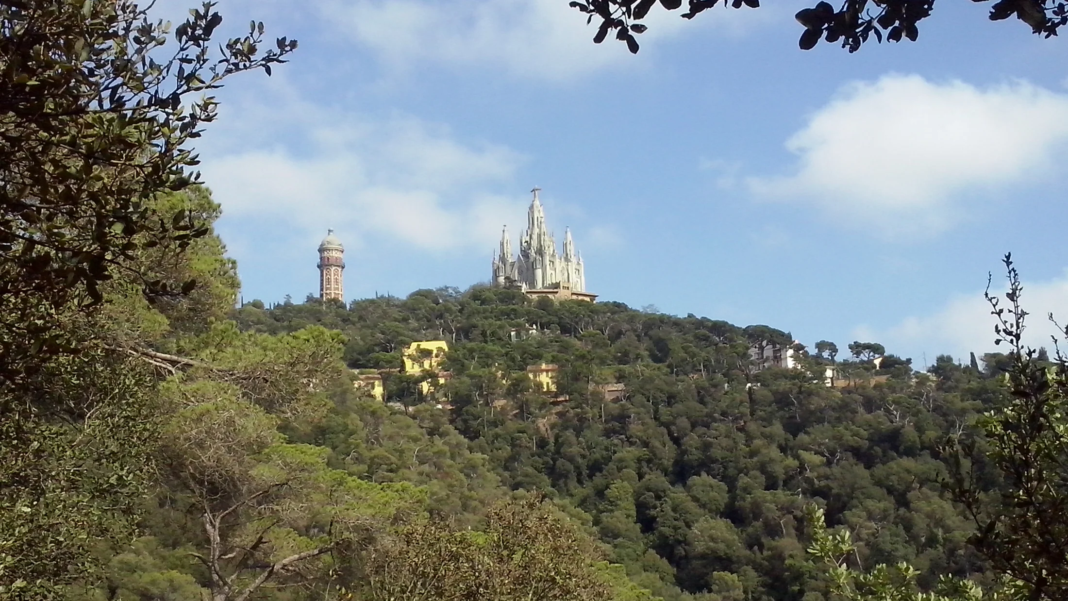
1.Montserrat — Sant Jeroni: iconic summit and 360° views
The serrated skyline of Montserrat pulls you from the city like a magnet. Choose this if you want a classic Montserrat hike from Barcelona that feels wild yet well-marked. From the Monastery to Sant Jeroni summit, expect 12–15 km round trip, 700–900 m ascent, and 4–6 hours depending on pace and route variations (PR-C 19 style paths link). It’s moderate to demanding for casual hikers.
You’ll remember the cool shade of holm oaks giving way to sunlit conglomerate spires. Go by FGC R5 from Plaça Espanya to Monistrol de Montserrat, then take the rack railway up, or stay on to Aeri de Montserrat and ride the cable car. Typical rail time is 60–70 minutes; the cremallera takes ~15 minutes up; the cable car about 5 minutes. This is textbook senderismo transporte público Barcelona: frequent, predictable, scenic.
Highlights include the monastery complex, viewpoints like Mirador de Sant Jeroni, and the rugged rock formations that feel sculpted by giants. Start early to enjoy quieter paths and clearer light, carry at least 1.5 liters of water per person, and check for any temporary closures. Weekends can be crowded; aim for weekdays or dawn departures if you want solitude.
2.La Mola (sant Llorenç del Munt) — summit from Matadepera or Sabadell
La Mola gives you a real summit day close to home. The classic climb from Matadepera or Santa Fe de Valldoreix is a solid moderate outing: 10–14 km round trip, 600–800 m ascent, and 3.5–5 hours, depending on start point and minor variants (PR-C 171, SL-C connectors). The hermitage-restaurant atop adds history and a warm refuge in colder months.
Pine scent sharpens as the ridge narrows near the upper steps. For La Mola hiking by bus, ride Rodalies R4 to Terrassa or Sabadell, then a local bus to Matadepera trailheads; confirm schedules, as frequency varies by day and hour. From Barcelona–Plaça Catalunya to Terrassa/Sabadell is about 40–55 minutes, with another 15–30 minutes by bus, then a short walk to the start.
Why choose it? Panoramas over the Vallès, craggy sandstone ledges, and a distinct summit identity so close to the metro area. Start early in summer to avoid exposed midday heat, wear reliable grippy footwear for rocky steps, and bring a wind layer; La Mola’s top can catch gusts even on clear days. If descending to a different bus stop, note the last departures to avoid long roadside walks.
3.Pedraforca — scenic loop from Saldes in the Pre-pyrenees
Pedraforca is a Catalan emblem that delivers alpine drama without extreme altitude. The popular Saldes loop skirts the twin-toothed massif with viewpoints of the Pollegó Superior and Inferior, usually 12–16 km and 600–900 m ascent in 4–6 hours. Experienced hikers sometimes tackle a crest ascent, but the loop gives the views with less scrambling.
Cold air holds the scent of firs where the forest opens to scree. Getting there by public transport takes more planning: take a bus from Barcelona (main intercity stations) to Berga, then a regional bus to Saldes or Gósol; in some cases, a train to Vic on R3 plus bus to Berga also works. Avoid winter snow unless you carry proper equipment and know how to use it; autumn and late spring shine.
Expect stellar photography windows at Coll de la Trapa and belvederes along the circuit. Carry extra water—sources can be seasonal—and check return bus times early in the day. If weather shifts, drop into forest sections quickly; exposed ridges here can whip up sudden wind.
4.Parc Natural del Garraf — coastal crest from Sitges
Garraf’s white limestone and low sagebrush ridges contrast perfectly with the blue Mediterranean. A Sitges-based loop or traverse along the coastal crest typically runs 9–13 km with 300–500 m ascent in 3–4 hours, classed as easy to moderate. Waymarked paths link small eroded valleys, WWII-era lookouts, and sea-view balconies.
Salt on the air mixes with warm rock scents when the sun is high. Go with Rodalies R2 Sud from Barcelona–Sants or Passeig de Gràcia to Sitges (35–45 minutes), then start on foot from the station or ride a short local bus inland to begin higher. Parc Natural del Garraf hiking feels closer to the sea than you expect, and you can finish with a swim.
Highlights include Mediterranean scrublands, dry-stone shelters, and big south-facing vistas that glow at golden hour. Summer can be hot and bright; wear a brimmed hat and sunglasses, carry 1.5–2 liters of water, and mind slippery dust on descents. Shoulder seasons give comfortable temperatures and clearer horizons.
5.Montseny — Turó de l’home or Matagalls for forests and summits
Montseny blends deep beech forests with proud summits you can reach in a day. Choose Matagalls (1,697 m) or Turó de l’Home (1,712 m) via Santa Fe or nearby trailheads for 12–18 km, 700–1,000 m ascent, and 4.5–7 hours on firm paths. Foggy beech stands and granite outcrops bring a mountain feel far from urban edges.
A cool, earthy smell rises where leaf litter cushions each step in the woods. Reach Sant Celoni on R2 Nord in about 50–65 minutes, then connect by regional bus to Santa Fe del Montseny or a nearby stop; services concentrate on weekends and holidays in peak seasons. This is classic senderismo transporte público Barcelona—train backbone plus short bus—to reach high and return in a day.
Permits are not usually required for day hiking, but heed seasonal advisories on fire risk and trail closures on park channels. Bring layers for quick weather changes, especially above treeline; cloud banks form fast in Montseny. If you prefer an easier day, choose shorter forest loops around Santa Fe’s lakes and viewpoints.
6.Carretera de les Aigües (collserola) — easy, panoramic city-edge path
If you want maximum views with minimal logistics, this is your path. The Carretera de les Aigües is a near-level track contouring the Collserola slopes for roughly 7–10 km one-way, perfect for a 1.5–3 hour out-and-back. Surfaces are wide and compacted, ideal for families, runners, and new hikers.
City hum fades to birdsong as the skyline stretches from sea to Tibidabo. Access is seamless: take FGC to Peu del Funicular and ride the Vallvidrera funicular up, or use FGC to Sarrià and link with short walks to entry points. Collserola trails public transport access is as easy as tapping a metro card.
Why go? Big-city balcony views, sunset light over the Eixample grid, and a safe surface when trails are muddy. Start early on weekends to avoid crowds and share the path considerately with cyclists. Extend by connecting up to Tibidabo or down to neighborhood parks if you want extra steps.
7.Montjuïc — urban gardens, viewpoints, and heritage loop
Montjuïc is your low-commitment walking hill packed with history and views. Stitch together a 6–10 km loop in 2–3 hours linking Mirador de l’Alcalde, the castle, the Olympic Ring, and landscaped gardens—ideal when time is short or weather is uncertain.
Jasmine and citrus notes drift through terraced paths after a light rain. You can arrive by metro (L2/L3 to Paral·lel + funicular), multiple city buses, or even a short walk from Poble Sec or Plaça d’Espanya. Combine walking with funicular rides to save legs on hot days.
Cultural highlights flank the route: museums, fountains, and fortifications with bay views. Surfaces are mostly paved or good gravel, so regular trainers work. It’s a convenient warm-up or family walk that still delivers photo spots and picnic lawns.
8.Parc del Montnegre i el Corredor — forest trails from Mataró or Arenys
Looking for quiet Mediterranean forest without a long ride? Montnegre i el Corredor lies just above the Maresme coast, with 10–16 km loops from towns like Mataró or Arenys across cork oak, pine, and chestnut. Expect 300–700 m of ascent in 3–5 hours, on well-marked PR-C and local paths.
Dry pine needles crackle underfoot as a sea breeze cools the ridges. Take R1 to Mataró or Arenys de Mar (40–60 minutes), then a short local bus or a 20–30 minute uphill walk to the park edge; trailheads spread across hermitages and ridgelines. This is a solid choice if you want trails reachable by public transport from Barcelona with fewer crowds than coastal promenades.
Look for long views towards Montseny, spring wildflowers in clearings, and shaded ravines ideal on warm days. Bring enough water—springs are scarce—and note hunting closures in late autumn posted on park boards. Use GR-92 links if you want to mix in a slice of coast before or after the hills.
9.Sant Miquel del Fai — waterfalls, cliff monastery, and short paths
Sant Miquel del Fai pairs easy walking with striking geology and heritage. Plan 4–7 km of relaxed paths, cave-like ledges, and balcony viewpoints under travertine cliffs, perfect for families or mixed-experience groups. You can spend 2–4 hours here comfortably with time for photos and snacks.
Cool spray from waterfalls settles on skin as you cross shaded walkways. Reach the area with a train to Granollers Centre (R2 Nord) or Mollet-Sant Fost (R2/R3 connections), then a regional bus towards Sant Feliu de Codines or Riells del Fai and a final approach by foot or short taxi. Check current visiting rules and opening times; entry can be regulated to protect the site.
Highlights include the historic cliff-hugging monastery, cascades in wetter months, and kid-friendly paths with guardrails. Wear shoes with good grip for damp rock, and bring a light layer—shade keeps temperatures lower than valley towns. It’s a great close-to-Barcelona heritage walk without committing to a full mountain day.
10.Camí de Ronda — coast between Sitges and Vilanova i la Geltrú
This coastal stretch blends seaside paths, coves, and mild limestone bluffs. The common Sitges-to-Vilanova section runs 6–8 km one-way in 2–3 hours with minor ups and downs, mostly easy terrain with some narrow cliffside track. You can also split into shorter out-and-backs from either town.
Waves pulse against rock shelves while gulls wheel overhead on breezy days. Use R2 Sud to Sitges or Vilanova; hike one direction and ride the train back from the other town. This loop-free logistics makes it a perfect quick plan year-round, with shoulder seasons best for cooler temperatures and thinner crowds.
Expect small viewpoints, historic coastal buildings, and access paths down to pocket beaches. Wear sun protection and avoid sections during heavy swell or after storms when spray slicks the path. Pack light sandals in summer if you plan a cove dip before the return train.
What to Do Along the Way: Views, Heritage, and Seasonal Nature
Small choices can enrich a hike without adding hours. Aim for panoramic points early or late in the day—Sant Jeroni’s summit for a 360°, Garraf’s south-facing ledges for glowing seas, and the open knolls on Montnegre ridges for Maresme-coast frames. Photographers get cleaner horizons in autumn and winter when air is drier.
A hush falls over beech woods in Montseny where diffuse light glows on moss. Heritage lies close to the path system: Montserrat’s monastery and hermitages, La Mola’s hilltop sanctuary, Montjuïc’s fortress and Olympic sites, and Sant Miquel del Fai’s carved chambers. Plan a 15–30 minute stop at one cultural point rather than rushing past several; you’ll remember details rather than fragments.
Picnic spots are plentiful and often signed. Near Santa Fe (Montseny) you’ll find meadows by water; in Collserola, benches appear at Carretera de les Aigües viewpoints; Garraf has shaded terraces near ruins. Pack out all waste and use designated bins in town—Mediterranean scrub burns easily and needs care.
For flora and fauna, spring brings wildflowers across Garraf and Montnegre verges; autumn in Montseny can mean beech color and mushroom foraging with permits where applicable. Birders should watch for raptors along Montserrat cliffs and coastal species on the Camí de Ronda. If time is short, prioritize one “focus”: a sunrise view, a heritage stop, or a picnic meadow, and set a simple schedule around that highlight.
Logistics That Keep Days Smooth: Safety, Apps, and Backups
Good logistics create relaxed hikes. Start by downloading official or reputable offline maps for your target area and carrying a paper backup if the route is new to you. Set alarms for train departures and last-ride windows; leave a 10–15 minute buffer for platform changes or bus stops, especially in unfamiliar towns.
The mineral tang of a water fountain is welcome when the pack feels heavier late in the day. Use these tools:
- Rodalies de Catalunya app and website for
R1,R2,R3,R4timetables and live updates. - FGC app/site for
R5and funiculars (e.g., Vallvidrera) and Montserrat links. - Generalitat transit portal for regional buses and weekend mountain shuttles.
- Meteocat (Catalan Met Service) for local weather and wind on summits.
Pack like a local: 1.5–2 liters of water per adult (more in heat), sun protection, a light wind/rain layer, snacks with salt, and shoes with grip. In shoulder seasons, gloves and a warm hat can turn a windy summit into a joy instead of a trial. Keep a small first-aid kit and a charged power bank.
Safety is simple: avoid exposed ridges in thunderstorms, turn around if time slips, and share plans with a friend if you venture beyond urban parks. In emergencies, dial 112 in Catalonia; carry your precise trail name or a coordinate from your phone. If you miss the last bus, check for alternative stations on a different rail line or rides to a larger hub; leaving your route flexible by 30–60 minutes usually prevents stress.
Book your experience — discover outdoor activities in Spain with vetted providers on Picuco.
Faqs and Conclusion
Which hikes are best for beginners without a car?
Start with Carretera de les Aigües (flat and panoramic), Montjuïc loops (urban paths and gardens), and short Garraf crests from Sitges (3–4 hours, moderate sun exposure). All three are reachable by frequent trains or metro plus funicular or short bus.
How do I check late return options on Sundays and holidays?
Use the Rodalies and FGC apps for live updates and the Generalitat bus portal for regional buses. Filter by your date, and note the “Observations” section for weekend/holiday differences. Aim for a return one train earlier than the last published to keep options.
Do I need permits or to pay an entrance fee for these parks?
Most day hikes are free with no permits required. Specific heritage sites like Sant Miquel del Fai can regulate entry and hours, and some Montserrat facilities have ticketed areas. Always review the park’s official page on the morning of your trip for any temporary restrictions.
What should I pack for shoulder-season mountain days?
Carry layers: a light insulated jacket, windproof shell, gloves, beanie, and a warm base layer. Add 1.5–2 liters of water, snacks, a headlamp in case you run late, and an offline map. Grippy footwear matters more than heavy boots on these surfaces.
Can I do Montserrat’s Sant Jeroni in summer?
Yes, with an early start. Take the first R5 train, ride the rack railway or cable up, and aim to be on the trail by 9:00. Carry extra water, wear sun protection, and favor shaded approaches on the ascent. Avoid midday climbs in heat waves.
Are Collserola trails suitable for strollers or bikes?
Carretera de les Aigües is multi-use and wide; it suits jogging strollers and family cycling with care. Narrow singletracks around it may be uneven or stepped, so choose entry points that stay on the main track for a smoother surface.
In short, Barcelona’s rail and bus grid turns wild edges into easy, affordable escapes. Check timetables the night before, choose a route that matches your time and energy, and pack the basics for sun, wind, and a relaxed picnic view. When you’re ready to go deeper, extend your day into a weekend base in Monistrol, Sitges, or Sant Celoni, and let the next train take you to tomorrow’s trail.