Why a Countryside Picnic Is the Perfect Plan Right Now
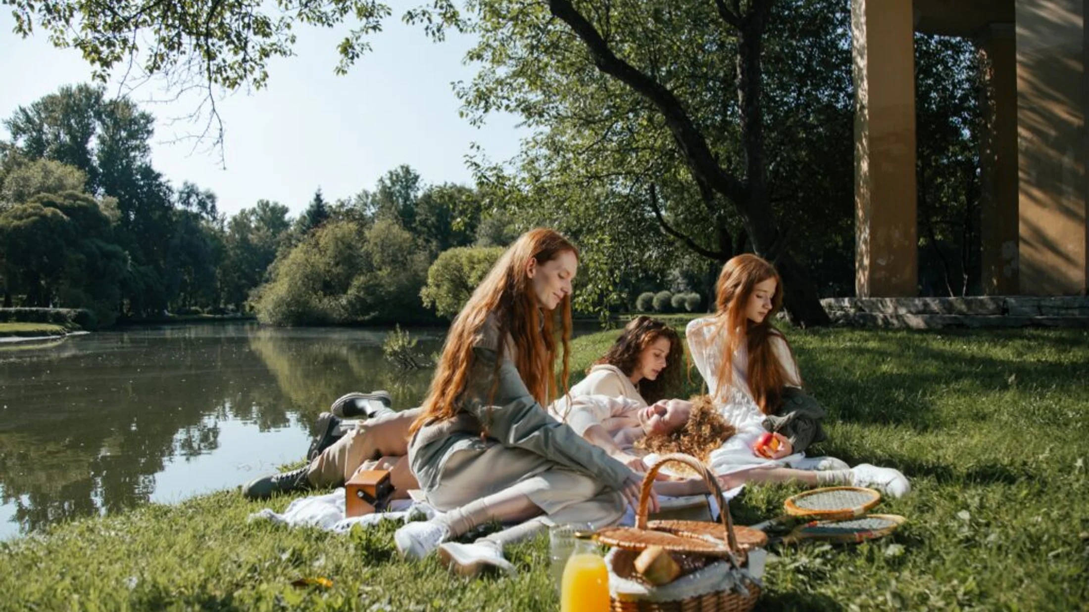
You pack simple food, step off the road, and the countryside does the rest. A countryside picnic blends recreation, local flavors, and real time outdoors—exactly what many in Spain now seek for day trips and low‑stress weekend escapes. Across regions, families, couples, and hiking groups embrace picnic routes that turn a walk into a shared meal with a view; it’s affordable, flexible, and invites you to slow down. Warm bread, ripe tomatoes, and olive oil taste different when eaten with a horizon of oaks or sea cliffs.
This guide gathers ten carefully selected picnic routes Spain-wide, each with clear directions, difficulty, and the single best picnic spot along the way. You’ll find gentle circuits for strollers, moderate hikes that earn a panorama, and coastal paths that drop to coves. We balance inspiration with facts you can plan around—distances, access, seasons, and rules—so you can match an epic picnic spot to your group and your time. According to AEMET climate normals, spring and autumn offer mild temperatures across much of inland Spain, while coastal breezes favor early or late summer outings; we factor that into when to go.
Use this article three ways: pick a route by region, choose by your profile (family-friendly, romantic, or hiking and picnic combo), or skim the essential info to time your day right. For couples, look for short sunset loops near scenic picnic locations; for families, prioritize shade, water access, and services; for hikers, target routes with a mid‑trail ledge or meadow to rest and refuel before continuing. A lone thrush’s call over a meadow can make a sandwich feel like a feast. Pack light, tread gently, and discover how food, landscape, and local communities come together out there.
Picuco te puede ayudar
Does something here catch your eye?
Tell us.
Write to us on WhatsApp or email: we answer questions, find the best options and help you sort out the booking.
When to Go, Where to Go, and How to Reach the Trailheads
Timing makes the difference between a fine meal outdoors and a hot, rushed one. Across most inland routes, April–June and late September–November bring reliable walking temperatures (15–22°C) and stable light for lunch or sunset. In high mountains like Picos de Europa, snow can linger into May; check park advisories before setting out. On the Mediterranean, coastal paths catch sea breezes, but plan for early starts (begin 8:00–9:00) or late afternoons to picnic after 18:30; midday sun still bites in July–August. For bird‑rich canyons like Duratón, mornings offer activity and shade, while evening thermals lift vultures into effortless spirals overhead.
Getting there is part logistics, part pleasure. Public transport reaches many bases: Cangas de Onís for Covadonga (Asturias), Poncebos for the Cares side (limited services), Tossa de Mar for the Camí de Ronda, Sepúlveda for Duratón, Manzanares el Real for La Pedriza, Valencia city buses to El Palmar (Albufera), and Barcelona FGC trains to Monistrol for Montserrat. Still, a car often shortens transfers and allows a coolbox; expect park‑and‑ride or controlled car access in peak periods. For example, the Covadonga Lakes operate a seasonal shuttle bus and restrict private cars on many summer days; La Pedriza limits parking at Cantocochino on busy weekends and holidays, closing once capacity is reached. Arrive early (before 9:00) or plan mid‑week to reduce stress.
As a rule, start hikes in the morning for shade on ascents and space at the best picnic spots. Sunset picnics are magical on safe, short routes with clear returns—Montserrat’s miradors or Albufera’s levees—so pack headlamps just in case. Check AEMET forecasts the evening prior and the morning of your trip; thunderstorms can develop on hot afternoons in mountains, while Levante winds roughen seas on the southeast coast. The resin scent of pines drifts strongest before noon when air is still.
Permissions and rules protect these places and your day. Inside protected areas (Parque Nacional de Picos de Europa, Parque Natural del Cabo de Gata‑Níjar, Hoces del Río Duratón, Sierra de Grazalema), open flames are prohibited year‑round; portable stoves are typically banned in high‑risk seasons. Some routes, like the Pinsapar in Grazalema, require a permit and often a guide—choose alternative circuits if permits are full. In canyon and coastal reserves, stick to marked trails to avoid erosion and nesting sites. Dogs must be leashed in most parks; in national parks, leashes are mandatory. For current access and any shuttle details, contact local visitor centers or official park offices in the week before your trip; staff can confirm closures, parking quotas, and wildlife advisories.
Parking varies. Expect free but limited lots at trailheads like San Frutos (Duratón) and Cantocochino (Pedriza); paid or managed access at popular beaches in Cabo de Gata (Monsul, Genoveses) in high summer; and municipal parking near coastal villages (Tossa, Begur). Always carry cash or a bank card for automated barriers. Water taps exist at monasteries, villages, and some park entrances, but not mid‑trail—fill 1.5–2 liters per person for half‑day walks, more on arid routes. If you’re traveling without a car, cluster your plan around a town with frequent buses or trains, then pick a nearby low‑logistics path; you’ll picnic sooner and travel smarter.
Staying Overnight: Rural Stays, Campgrounds, and Simple Refuges
Turning a picnic into a whole escape is easy if you sleep near the trail. Around these routes, you’ll find rural hotels, casas rurales (country homes), campgrounds, simple hostels, and occasional mountain refuges. For a day picnic, proximity and parking beat bells and whistles; for a weekend, you might value a kitchenette for prepping salads and chilling drinks. Many rural stays in Spain offer communal kitchens or guest fridges—ask ahead, especially in summer when food safety matters.
- Rural hotels and casas rurales:
- Typical ranges: 60–120 € per double room per night; entire homes vary widely by size and season.
- Best for: couples and families who want quiet evenings and local produce nearby.
- Look for: kitchen access, shaded gardens, and advice on less‑known picnic routes Spain locals favor.
- Campgrounds and bungalows:
- Tent pitches from roughly 10–25 € per person; bungalows or mobile homes 60–120 € per unit.
- Best for: budget travelers, groups, and those who like dawn starts.
- Look for: on‑site small shops, ice, and laundry to handle picnic fabrics.
- Refuges and hostels:
- Dorm beds 18–35 € per person; simple facilities and early quiet hours.
- Best for: hikers keen to pair hiking and picnic without long transfers.
- Look for: baggage storage, packed lunch options, and early breakfast.
Reserve early for spring weekends and summer coastal dates; popular parks and beaches fill up weeks in advance. Prices shift with festivals, school holidays, and local events—confirm on the provider’s site or consult Picuco to compare options by region and activity. To combine lodging and a standout countryside picnic, plan your food shop at nearby markets or cooperatives: buy seasonal fruit, local cheeses, bread, cured meats, and a pastry for dessert. Many towns hold weekly markets (often Saturday), while small groceries keep Sunday hours in tourist areas. A single sprig of rosemary crushed between your fingers can perfume a whole basket.
Two smart combos maximize your time:
- Arrive Friday evening, shop local early Saturday, hike and picnic late morning, siesta at your stay, then a short sunset stroll for photos.
- Start with a sunrise loop, picnic brunch in shade, swim if allowed, and nap at the stay before a simple dinner out.
If you travel without a car, choose accommodations within 2–3 km of the trail start or with bus connections; some hosts can arrange taxis to trailheads at fair local rates. Always ask about water refill points and park rules—they vary by municipality and season, and locals keep the freshest information.
The 10 Countryside Picnic Routes: Where to Walk and Exactly Where to Spread Your Blanket
Picos de Europa (lagos de Covadonga): alpine meadows above mirror-still lakes
Start with the short circuits around Enol and Ercina, a family‑friendly loop of 5–6 km, gentle undulations, and firm tracks. Access the lakes via shuttle bus on most high‑season days from Cangas de Onís, with private car access limited; arrive early or go off‑peak for calm. The best picnic spot sits on the pradera above Lake Ercina, where flat turf, scattered cattle, and views to limestone walls make it one of the best picnic spots in the country. The breeze carries the sweet smell of high grass and dairy pastures.
- Route notes:
- Difficulty: easy; altitude ~1,100–1,200 m; allow 2–3 hours with stops.
- Services: seasonal cafés near the parking; no mid‑trail fountains—carry water.
- Rules: national park—no fires, pack out all waste; grazing areas require gates closed behind you.
- Variants: Shorten to the
PR-PNPEsigned circuits around each lake, or extend to the Mirador de Entrelagos for a higher vista. If fog rolls in (common), stick to marked paths and avoid wet limestone edges.
Ruta del Cares (garganta Divina): a balcony path through a vertical world
This legendary traverse runs about 12 km one way between Poncebos (Asturias) and Caín (León), clinging to a man‑made ledge above the Cares River. Choose your direction based on logistics: out‑and‑back from either side, or arrange a two‑car shuttle to avoid a forced return. Aim to picnic at a wide, level lay‑by roughly 4–5 km from Poncebos, where dry stone walls and a broad bench of track make a safe pause with vast gorge views—perfect for hiking and picnic combined. The river roars faintly like distant wind as griffon vultures ride thermals.
- Route notes:
- Difficulty: moderate for length and exposure; little shade; allow 5–7 hours round trip.
- Services: no water on the path; fountains in villages only—carry 2–3 liters in summer.
- Safety: avoid narrow spots for lunch; keep children close; stonefall risk increases after heavy rain.
- Variants: Short family‑friendly tasters from Caín side (flatter first kilometers). To dodge crowds, start at dawn or go outside peak months (July–August).
Camí de Ronda (costa Brava): cliff paths and coves in turquoise light
Walk the emblematic stretch of the GR-92 between Tossa de Mar and Cala Pola, about 3 km one way with stairs and short ups and downs. The path threads pine shade, viewpoints, and rocky outcrops above clear water; footing is good but occasionally steep. Ideal picnic locations include Cala Pola itself—small sandy beach with some shade—or the mirador just before it, a flat rock platform with railings set back from the cliff. Resin, salt, and thyme scent the air with every gust.
- Route notes:
- Difficulty: easy‑moderate due to steps; allow 1.5–2 hours one way with photo stops.
- Services: beach bars may open seasonally; bring water and sun protection year‑round.
- Safety: watch children near drop‑offs; avoid edges after rain when rock is slick.
- Timing: For routes with views for picnic, arrive early for calm seas and space, or plan a late picnic after 18:30 to miss midday crowds and catch golden light.
Hoces del Río Duratón (segovia): canyon rims, hermitages, and circling vultures
Inside the Parque Natural, the classic walk to the Ermita de San Frutos offers a 5–6 km round trip on wide tracks with jaw‑dropping bends of the Duratón below. Picnic on the flat meadows near the hermitage, where stone benches and open turf provide safe, breezy seating away from canyon edges. The air thumps softly when a vulture passes close, like a book closing in slow motion.
- Route notes:
- Difficulty: easy; minimal elevation; allow 2–3 hours with stops.
- Services: parking near the track’s end (limited); no water onsite—fill up in Villaseca or Sepúlveda.
- Conservation: stay back from rim edges; vultures nest on cliffs—quiet enhances sightings.
- Variants: Extend along the rim track for different angles, or pair with a canoe trip from authorized operators downstream (respect seasonal nesting restrictions set by the park).
La Pedriza (sierra de Guadarrama): granite playgrounds and soft meadows
La Pedriza’s lower circuits deliver shady streams, rounded boulders, and pradera clearings perfect for a countryside picnic. A family‑friendly loop from Cantocochino to Charca Verde and back can be tailored 5–9 km, with plenty of rest spots between slabs. The best blanket‑worthy clearings sit in meadows above the river on the return leg, away from crowded pools and on flat grass under holm oaks. Warm granite radiates gentle heat as water chatters over polished stones nearby.
- Route notes:
- Difficulty: easy‑moderate; some rocky steps; allow 3–4 hours with a long lunch.
- Access: parking at Cantocochino fills early; seasonal capacity limits apply—arrive before 8:30 or choose weekdays.
- Park rules: no fires or stoves; swim only where permitted; keep to signed paths to protect fragile soils.
- Variants: Shorten to an out‑and‑back to the first wide pools, or extend up to Cotos de Monteros for quieter meadows. Families: carry extra water and a light blanket to soften rocky seats.
Lagunas de Ruidera Natural Park: strings of blue, shade, and shorelines
This chain of karst lagoons between Ciudad Real and Albacete invites short walks that hop between viewpoints, mills, and beaches. A simple 4–7 km mix‑and‑match walk from Laguna del Rey to Laguna San Pedraza keeps you near water and shade. Prime picnic zones include small interior “playas” with reed‑backed sand and poplar shade, set back from lifeguarded swim areas in high season. Sunlight flickers on the lagoon like coins scattered across blue glass.
- Route notes:
- Difficulty: easy; mostly flat; allow 2–3 hours including a swim.
- Services: multiple parking areas; seasonal fees; cafés and rentals near main beaches; toilets at some official zones.
- Activities: safe swimming in designated areas; kayak and SUP rentals in season—confirm times locally.
- Variants: Create a stroller‑friendly stroll along paved sections near Ruidera town, or a longer circuit linking three lagoons at dawn to beat heat and traffic.
Albufera de Valencia: levee walks, rice fields, and sunset boats
Just south of Valencia, the Albufera mixes lagoon, rice paddies, and traditional fishing communities. Easy levee walks from El Palmar or Gola de Pujol let you pair short there-and-back strolls (2–5 km) with a picnic by calm water. Best picnic locations are on levees with benches away from traffic, or the small dune‑backed clearings near the Gola de Pujol lookout for an evening spread before sunset boat rides. Evening air smells faintly of rice straw and brackish water.
- Route notes:
- Difficulty: very easy; flat; plan 1–2 hours plus sunset time.
- Services: restaurants in El Palmar; boat trips run seasonally; bring repellent for mosquitoes.
- Environment: protected birds; stay off crop margins; keep dogs leashed near nesting zones.
- Local flavor: Consider a post‑picnic paella in El Palmar or buy ingredients from village shops for your own spread; for picnic and hiking, string together short footpaths between observation points.
Sierra de Grazalema: limestone folds, cork oak shade, and white villages
Grazalema’s karst landscape hosts some of Spain’s highest rainfall, keeping valleys green deep into spring (AEMET reports annual totals often exceeding 2,000 mm on windward slopes). Choose a short loop such as Llanos del Endrinal (6–7 km) or a gentle PR-A path from Puerto del Boyar to miradors with broad views. Picnic where cork oaks give deep shade and flat clearings open beside old cortijos, keeping away from fragile sinkholes and wildflower patches. The scent of damp earth lingers even on bright days.
- Route notes:
- Difficulty: easy‑moderate; rocky ground; allow 2.5–3.5 hours.
- Services: fountains are scarce mid‑trail; refill in villages; some refuges and visitor centers provide info.
- Conservation: the Pinsapar requires permits and is often off‑limits during high‑risk periods—choose alternative meadows to protect endemic flora.
- Variants: In hot spells, start before 8:00 and stick below treeline; in shoulder seasons, add a stop in the white village of Grazalema for cheese and bread to elevate your picnic.
Cabo de Gata-níjar Natural Park: lava headlands and secret coves
Arid volcanic hills drop to bays of clear water and pale sand; the classic experience is a short coastal walk linking beaches like Genoveses and Monsul or exploring the path east of San José. Plan 4–6 km total, saving energy for swims. Picnic on higher ledges set back from the beach or in dune shade behind Monsul—always beyond marked protections—to catch views without windblown sand. The air tastes of salt and sun‑warmed dust.
- Route notes:
- Difficulty: easy; sandy paths; little shade; carry 2–3 liters per person in summer.
- Access: high‑season vehicle restrictions to popular beaches; shuttle buses often operate—confirm dates locally.
- Safety: currents vary; heed flags; no fires; leave dunes and plants undisturbed.
- Variants: Explore early morning coves for solitude, then picnic late under a cliff’s shadow; snorkel along rocks where seas are calm, avoiding reserve zones as signed.
Montserrat: stone waves, monasteries, and picnic perches
From the monastery, waymarked paths weave to miradors like Sant Miquel or the Camí de les Ermites; add the Sant Joan funicular to save ascent. A 4–6 km loop delivers big views with modest effort, and your prize picnic spot is a natural stone “table” near Mirador de Sant Miquel, slightly off the main flow but still on secure ground. Warm rock under your palms seems to hold the day’s light as bells drift from the abbey.
- Route notes:
- Difficulty: easy‑moderate; occasional steep sections; allow 2–3 hours plus lunch.
- Access: trains to Monistrol and rack railway or buses up; funiculars save time.
- Culture: dress respectfully around the basilica; pack away food neatly when visiting indoor spaces.
- Variants: Shorten to the Camí de les Bateries for gentle gradients, or extend along the
GR-172contour path for quieter corners.
What to Do Beyond the Blanket: Wildlife, Water, and Viewpoints
A picnic anchors the day, but the landscapes invite more. In canyons and wetlands—Duratón and Albufera—birdwatching is rich: bring compact binoculars (8x32 is light) and a quick reference list; mornings and pre‑sunset hours show the most action. In mountains like Picos and Montserrat, short detours to miradors make for perfect pre‑ or post‑lunch leg‑stretches; keep distances short so digestion and heat don’t sap energy. In coastal circuits—Camí de Ronda and Cabo de Gata—water play adds spice: plan a reef‑edge snorkel where visibility is safe and permitted, or a wade for kids in calm, shallow coves.
- Family‑friendly activities:
- Treasure hunt: list 10 finds (a pine cone, a feather, a white flower) and let children explore within sight.
- Sound map: sit quietly 2 minutes and draw what you hear; it slows everyone down.
- Stream science: in Pedriza or Ruidera, teach “leave no trace” by lifting a stone, observing life, and replacing it gently.
- Couple‑friendly moments:
- Sunrise thermos coffee at a viewpoint before crowds, then a late picnic brunch.
- Golden‑hour photography: shoot backlit grasses and rimlight on rocks for memory‑worthy images.
- Hiker add‑ons:
- Route extensions: add 1–2 km after lunch on a loop so you digest while moving, not on exposed ascents.
- Micro‑skills: practice map reading or identifying trail marks like
GRred‑white blazes orPRyellow‑white.
Water‑based fun works best where designated: in Ruidera’s bathing zones, at calm Costa Brava coves, or under lifeguard flags in summer. Always confirm local advisories; currents change with wind and season, and some areas restrict access for nesting or dune recovery. For canyon rims like Duratón and cliff paths like Camí de Ronda, prioritize seated viewpoints set back from edges; stable ground makes eating safer and more restful. The crunch of an apple grows louder when you’re still enough to notice wind in reeds or bees in thyme.
When choosing which extras to prioritize, match them to landscape and heat. Inland spring days: mix wildlife and short walks. Summer coasts: favor swims, shade, and later picnics. Autumn mountains: longer viewpoints and photography under clear air. Whatever you choose, keep community in mind—share space on benches, greet shepherds and fishers, and buy small from villages whose work sustains these places.
Practical Tips for a Countryside Picnic Done Right
Preparation keeps your meal fresh and your footprint light. Pack a soft, insulated bag; use ice packs or frozen water bottles to hold 0–5°C for perishables, and separate raw from ready‑to‑eat foods. Choose stable, picnic‑proof dishes: empanadas, tortilla, hard cheeses, cured meats, hummus, olives, seasonal fruit, nuts, and sturdy salads (lentils, pasta, tabbouleh). Avoid mayo‑heavy items in heat; if bringing fish or dairy, eat within 2 hours of leaving the fridge, or keep properly chilled until serving. Bread and oil thrive anywhere.
- Essentials checklist:
- Blanket or sit pads; lightweight tarp if ground is damp.
- Reusable containers and cutlery; cloth napkins; a sharp pocket knife with sheath.
- 1.5–3 liters water per person (more on arid routes); electrolyte tabs for hot days.
- Sun: hat, sunglasses, SPF 30+; long sleeves in strong sun.
- Safety: small first aid kit (plasters, bandage, blister care), headlamp, whistle, paper map or offline map.
- Clean‑up: trash bags, a spare zip bag for organics; hand gel or biodegradable wipes.
- For families:
- Pack extra snacks and a small toy; choose shady spots near safe paddling if available.
- Keep walks under 6–7 km with frequent micro‑goals (a rock, a tree, a view).
- For hikers:
- Distribute weight; stow food near the top for easy access; use
GR/PRsignage to pace stops. - Eat salty foods early in heat; save sweets for the last hour.
- Distribute weight; stow food near the top for easy access; use
Sustainability matters. Replace single‑use plastic with steel bottles and beeswax wraps; avoid glass near water and on rocks. Leave no trace means everything out comes back—orange peels and nut shells don’t belong under oaks. In fire seasons (often June–October, varies by region), flames and stoves are banned in most natural areas; choose cold menus and distance yourself from dry grasses. If you spot smoke or fire, call 112, move uphill only if safe from flames and wind, and follow any ranger instructions. Leather smells warm and faintly sweet when sun hits your pack—enjoy that small detail, but never at nature’s expense.
Dogs: keep leashed per park rules; bring a collapsible bowl and extra water; avoid fragile dunes and crops. Ticks: in tall grass, wear long trousers and check ankles and waist after; remove promptly with fine tweezers. Respect quiet: music travels far and disturbs wildlife and people; let wind and birds score the day. Finally, thank the people whose work holds the land together—grazers keep meadows open, fishers know the tides, and rangers balance access and protection. A friendly chat can point you to an even better lunch rock.
Frequently Asked Questions
Do I need permits for these routes?
Most listed routes are free‑access, but specific areas require controls. In Picos de Europa, summer vehicle access to Covadonga Lakes is restricted and a shuttle runs instead; in Sierra de Grazalema, the Pinsapar route needs a permit and may require a guide. Always check the official park or visitor center pages a few days before your trip for current rules and any closures.
What foods travel best for a hot day outdoors?
Favor low‑risk, resilient foods: hard cheeses, cured meats, nuts, firm fruit (apples, pears, grapes), olives, and grain‑based salads dressed with oil and lemon. Avoid mayonnaise or fresh dairy unless kept cold with ice packs. Pack bread and a small bottle of olive oil for versatility, and eat perishable items first.
How much water should I carry, and is stream water safe?
Plan 1.5–2 liters per person for easy half‑day walks; 2–3 liters in arid or exposed routes like Cabo de Gata or the Ruta del Cares in summer. Treat all natural water as non‑potable unless signed otherwise; carry your own or use a reliable filter and disinfectant tablets if you must refill, then still prefer official fountains in villages or trailheads.
What should I do if there’s a wildfire risk or I see smoke?
In high‑risk seasons, fires and stoves are prohibited in most natural spaces; pack a cold picnic. If you see smoke or flames, call 112 immediately, move away perpendicular to the fire’s path and out of gullies, and follow ranger or firefighter instructions. Do not block access roads with parked cars; these are emergency corridors.
Can I bring my dog on these picnic routes?
Yes on many, but rules vary. In national parks (e.g., Picos de Europa) dogs must be on a leash at all times. In wetlands and dune systems (Albufera, Cabo de Gata), keep dogs leashed and off nesting areas. Carry water, avoid hot sand at midday, and pack out waste. Check local signage at each trailhead.
When is the best season for a countryside picnic in Spain?
Spring and autumn offer the most comfortable inland temperatures and stable light. Coastal routes can work all summer with early or late starts and shade planning. Mountain routes like Picos open progressively from late spring as snow retreats; winter days can be crisp and clear but short—start early and dress in layers.
Book your experience — discover outdoor activities in Spain with Picuco-verified providers.
Conclusion
A countryside picnic turns simple food into a shared moment shaped by landscape, light, and the people around you. Now you have ten routes—from alpine meadows and canyon rims to coves and rice fields—each with a clear, safe spot to sit and savor. Choose by your profile: families seeking shade and water, couples chasing sunset views, or hikers pairing effort with a panoramic rest. Time your outing for mild hours, pack sustainably, carry enough water, and respect local rules and communities who care for these places.
If this sparked ideas, pick a route and put a date on it; small plans become real escapes when scheduled. Consider saving this list, building a simple pantry‑to‑picnic menu, and inviting someone who needs a breath of fresh air. When you return, share what worked and what you discovered; your notes help others travel kindly. The taste of ripe tomatoes in the wind is waiting—go find your rock, your meadow, your view, and let the countryside do the rest.