Why Spain’s Desert‑like Landscapes Feel Otherworldly
Spain hides places where clay and light carve planets within a day’s drive. In Bardenas Reales, wind and rare rains sculpt ridges, chimneys and gullies that look lunar at sunset. You feel small as ochre walls glow like embers. Use this guide to choose your area, plan days on the ground, and travel safely.
Geology and what you’ll see
Erosion is the quiet architect here. Soft sediments—clays, marls and gypsum—wash into ribs and hoodoos when rare storms arrive, then bake under sun and wind. Picture a cake left in the rain, then dried hard: edges sharpen, gullies deepen, and isolated towers remain. The result is badlands—heavily eroded terrain—where shapes change within a season yet feel timeless at dawn.
- Bardenas Reales (Navarra) combines clay, sandstone and gypsum under a semi‑arid climate that yields mesas and iconic “chimneys” like Castildetierra. In dry air, footsteps crunch and the wind smells faintly of dust.
- Tabernas Desert (Almería) is drier still, its ramblas—ephemeral riverbeds—cutting grey and honey‑colored slopes. Sun on gravel shimmers like metal.
- Gorafe Desert (Granada) forms labyrinthine badlands in the Guadix‑Baza basin, with red and blonde bands like book pages. Silence wraps you as swifts knife across canyons.
- Yesos de Sorbas (Almería) are gypsum karst: crystalline white ridges, sinkholes and caves glinting under a hard sky. The rock feels almost sugary to the touch.
- Monegros (Zaragoza/Huesca) offers steppe and erosional tozales—isolated mounds—across wide, wind‑combed plains. The air carries the scent of dry thyme after brief rain.
These places look extraterrestrial because the ingredients are simple and exposed: soft rock, sparse plants, strong sun, and time. For travelers, that translates into big horizons, dramatic shadows, and fragile ground that demands care and respect.
What you’ll learn and who this is for
This article gives you what you need to turn wonder into a grounded plan. You’ll find how to get there, best seasons and times of day, 1–3 day itineraries, where to base yourself, and safety and photography advice. Expect distances, route codes, and coordinates when useful. The ground here can be rough but the logistics are straightforward.
- You’ll find options for independent travelers, couples, families with curious kids, and small groups.
- Photographers get golden‑hour timing, lens tips, and vantage ideas; hikers and cyclists get route suggestions and pacing.
- If you’re eyeing Bardenas Reales, we’ve added a dedicated section on access, tracks, rules and permits. A light breeze at dusk feels like a reward after a well‑timed day.
Use the overviews to pick your area, then dive into the activities section to shape a day‑by‑day plan. Keep water and respect high on your list, and the land will give you its quiet drama.
Picuco te puede ayudar
Does something here catch your eye?
Tell us.
Write to us on WhatsApp or email: we answer questions, find the best options and help you sort out the booking.
Five Otherworldly Places at a Glance
Start with this snapshot to choose what fits your time, season and style. Imagine tracing these lines on a map while morning light slides over ridges.
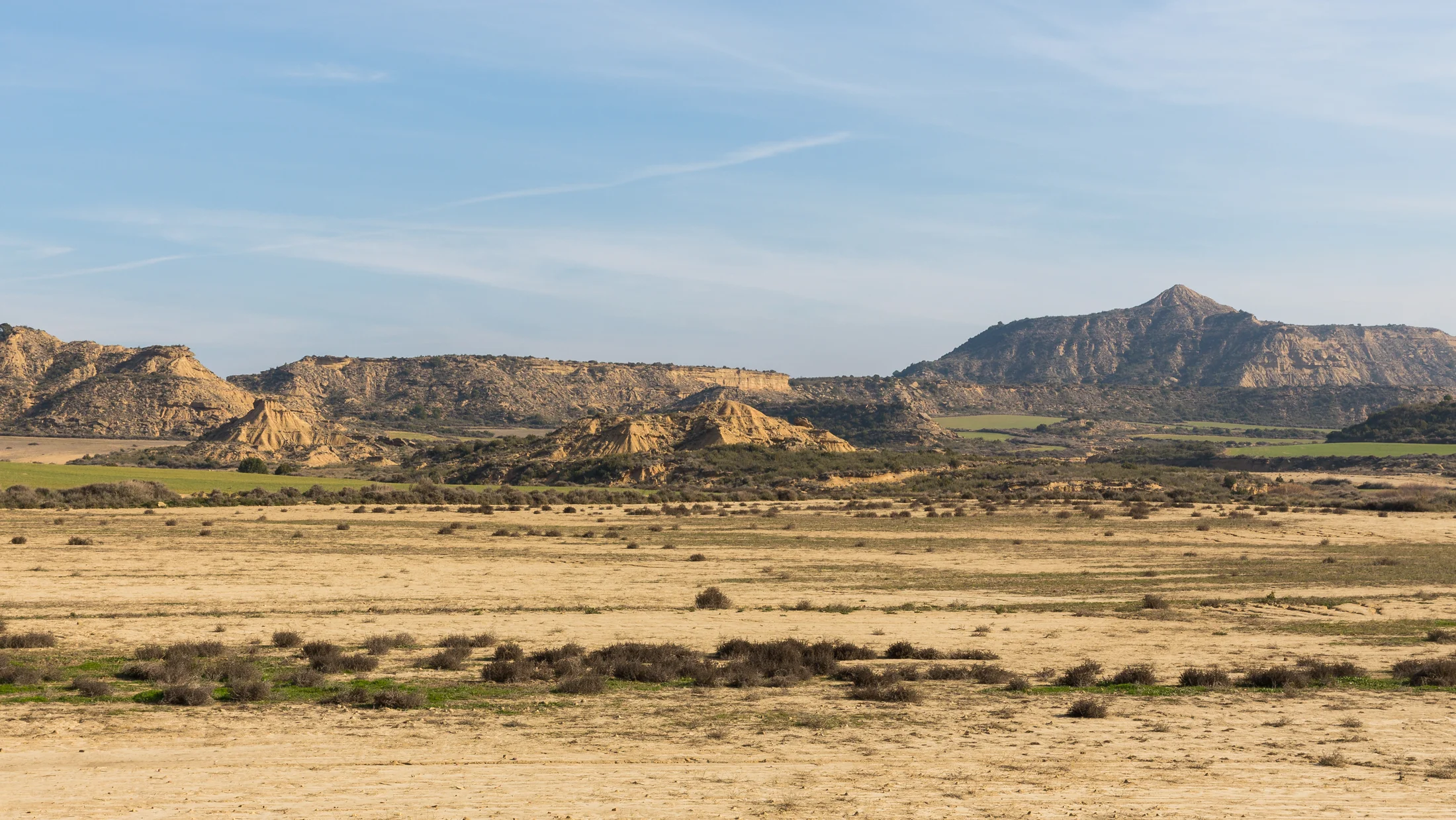
1.Bardenas Reales: Castildetierra and the emblem on Navarra’s edge
Bardenas Reales is a UNESCO Biosphere Reserve (2000) on Navarra’s southeast flank, a 42,500‑ha semi‑arid expanse roughly 20–30 minutes from Tudela by car. Its Bardena Blanca core showcases clay‑and‑gypsum badlands, with Castildetierra—an elegant earth chimney backed by a flat cap—its most photographed face. Late sun turns the slopes butterscotch; on windless mornings, even your breath feels loud.
- Location: South of Arguedas and Valtierra, near the
NA-134. Approximate coordinate for Castildetierra:42.200°N, 1.500°W. - What makes it different: Variety. Within short drives you move from flat cereal fields to sculpted valleys, from smooth planas (tablelands) to razor gullies. It’s wild yet well‑signposted.
- Access: Visitor information near Arguedas, main entrance via El Paso gate. A signed unpaved circuit encircles the Bardena Blanca; several official viewpoints lie a short walk from pull‑offs. Gravel crunches softly under tires; keep speeds low to notice the textures.
2.Tabernas Desert: Almería’s film‑forged horizons
Tabernas is arguably mainland Europe’s driest pocket, with annual rainfall near 200 mm and a maze of ramblas and badlands used in 300+ productions since the 1960s (Almería Film Commission data). Western‑style sets and outdoor film museums dot the landscape; away from them, you get long, empty washes and big skies. Heat radiates off pale slopes like a slow‑moving wave.
- Location: Between the Sierra Alhamilla and Filabres, 30–40 minutes north of Almería city via
A-92andN-340a. Town of Tabernas centers the area. Representative coordinate:37.050°N, 2.390°W. - What makes it different: Dryness and cinematic heritage. The rambla network offers level walking with sudden sculpted walls.
- Access: Good paved approaches, then dirt tracks; some film sets operate as attractions. Morning shadows sketch ribs on hillsides like ink lines.
3.Gorafe Desert: Badlands and textures in Granada’s Guadix‑baza basin
The Gorafe badlands unfurl north of the village, where the ancient Baza lake left layers now whittled into fins, amphitheaters and sharp ridges. Expect fewer crowds and a stronger sense of scale—tiny paths thread through massive forms. Rust‑red and cream bands glow at golden hour like coals under ash.
- Location: Province of Granada, around the town of Gorafe and the Negratín reservoir; about 1 hour from Granada via
A-92and local roads. Coordinate near village:37.479°N, 3.042°W. - What makes it different: Maze‑like erosion with solitude. A large megalithic park with over 200 dolmens adds cultural depth.
- Access: Mix of paved roads and rough tracks; some sectors are better with high‑clearance vehicles or guided 4x4. Wind hisses along knife‑edged ridges.
4.Yesos de Sorbas: Gypsum karst and moon‑white forms
The Karst in Yesos de Sorbas Natural Area is a rare gypsum world—glittering crystals, sinkholes, and dry valleys (poljes) contrasted with green ribbons along the Río Aguas. Surface ridges look snow‑dusted, but the crunch underfoot is warm. White rock against cobalt sky feels almost Arctic at noon.
- Location: Near the town of Sorbas, Almería; about 45 minutes from Almería via
A-7andA-1102. Approximate coordinate:37.098°N, 2.126°W. - What makes it different: Gypsum caves and surface karst, brilliant white textures, and short interpretive trails.
- Access: Only visit caves with accredited guides; surface paths are short and signposted. In still air, you can catch a faint mineral tang.
5.Monegros: Steppe, wind and eroded tozales between Huesca and Zaragoza
Monegros is not a true desert but a vast semi‑arid steppe where salt flats, cereal fields and sculpted mounds meet in a horizon‑hungry panorama. The famous Jubierre sector gathers tozales—isolated buttes—into a photographer’s playground. The wind (cierzo) brushes grass so it ripples like water.
- Location: Between Zaragoza and Huesca provinces, with hubs like Sariñena, Bujaraloz and Lanaja; the Jubierre area lies south of Sariñena. Representative coordinate near Sariñena:
41.792°N, 0.159°W. - What makes it different: Big steppe skylines, birdlife at Sariñena Lagoon, and sculptural landforms within short drives.
- Access: Paved roads to towns, signposted dirt in sectors like Jubierre; some tracks close in wet conditions. Dust hangs briefly in the air behind passing cars.
Location, Climate and the Best Time to Go
These five areas spread across Navarra, Aragón and Andalucía, at elevations roughly 250–1,300 m. Distances between them are large—Bardenas to Tabernas is a full‑day drive—so plan them as separate trips unless you’re on a long road journey. The sun is an ally for shadows and color, but a foe if you underestimate heat and dryness. The light at dawn feels cool on skin; at midday, rock radiates like a stove.
For a quick comparison, use the table below as a planning compass (values are indicative; confirm with AEMET climate normals for final prep):
| Area | Elevation (m) | Rain (mm/yr) | Summer highs (°C) | Winter lows (°C) | Best months |
|---|---|---|---|---|---|
| Bardenas Reales | 280–659 | ~300–400 | 32–36 | 0–5 | Mar–Jun, Sep–Nov |
| Tabernas Desert | 300–600 | ~150–250 | 38–42 | 6–10 | Oct–Apr (avoid peak heat) |
| Gorafe Desert | 700–1,300 | ~250–350 | 32–37 | −2–5 | Mar–Jun, Sep–Nov |
| Yesos de Sorbas | 400–600 | ~200–300 | 34–40 | 5–9 | Oct–Apr |
| Monegros | 250–500 | ~300–400 | 34–38 | 0–4 | Mar–Jun, Sep–Nov |
- Summer (Jul–Aug) in Tabernas and Sorbas brings extreme heat; start at sunrise and finish by 11:00, or plan twilight sessions. The smell of warm sage at dawn lingers sweetly in cooler air.
- Winter in Bardenas and Monegros can be cold and windy; dress in layers and watch for short‑day timing. Frost sparkles on clay like sugar on pastry.
- Spring and autumn are prime for all five—longer golden hours, cool mornings, and more stable tracks after winter wet or summer storms.
Photography and comfort hinge on light and shade:
- Best hours: One hour after sunrise and one before sunset for relief and color; blue hour for silhouettes; night for stars in Gorafe and Monegros on moonless weekends. As the sun drops, textures stand up like raised braille.
- Midday: Use it for cave tours in Sorbas, film‑set visits in Tabernas, or rest in shade near your base.
Weather can change plans quickly after rain. Clay turns to glue in Bardenas and Gorafe, making tracks impassable and dangerous. If storms loom, stick to paved roads and official updates. The slap of drops on dry dust is your cue to pivot.
Bardenas Reales: Getting There and Getting Around
Bardenas Reales lies 20–30 minutes southeast of Tudela (train station on the Madrid–Barcelona line) and just south of Arguedas and Valtierra. Arrive by car via AP-68 (Zaragoza–Bilbao corridor) and NA-134, then follow signs for the main entrance at El Paso, near Arguedas. Public transport reaches nearby towns; taxis or bikes bridge the last stretch. Early light on the ridgelines makes the final approach feel like arriving at a stage.
- Closest hubs: Tudela (services, train), Arguedas and Valtierra (rural stays), Carcastillo for access to Bardena Negra.
- Parking and access: Use signed lots and pull‑offs; never park on fragile crust or vegetation. Tires sink fast after rain like feet in wet flour.
Movement inside Bardenas follows strict but simple rules set by the park authority:
- Stay on marked tracks and roads; off‑track driving, biking or walking damages the soil and draws fines. Think of the thin surface as a crust you do not want to crack.
- The Bardena Blanca loop is a well‑signed unpaved circuit (roughly 30–35 km) with short detours to viewpoints like Castildetierra and Mirador de las Cortinas. It’s generally passable in dry weather by standard car if driven slowly.
- Check for military closures. A live‑fire training area (Polígono de Tiro) occasionally triggers temporary restrictions; notices post at entrances and on official channels. The low rumble of jets can echo across empty flats.
- After heavy rain, gates may close to protect tracks and for safety. Clay becomes slick and rutted; turning around before trouble is good judgment, not defeat.
Permits and norms to note:
- No wild camping or bivouac; use established accommodations and campgrounds outside the core. Night skies remain dark even from nearby villages.
- Drones typically require authorization from the park and Spain’s aviation authority; assume “no” unless you have written approvals.
- Dogs on leash; no fires; pack out all waste. Even a tossed peel looks wrong on pale ground.
Practical transport tips:
- Tires and speed: Keep to 25–40 km/h on gravel; reduce speed on washboard. Air down slightly only if you know how and have a compressor.
- Sightlines: Dust plumes hide bends; drive with headlights on and leave gaps when following others.
- Bikes: Gravel or hardtail MTB works well; bring spares and 2–3 L of water per rider in cooler months, more in summer. The dry wind can hide your sweat but not your thirst.
- Public options: Train to Tudela, bus to Arguedas/Valtierra (limited), then taxi or rental bike. Expect to be self‑reliant once inside.
Arrive early to park calmly, walk short view spurs in golden light, and keep your itinerary flexible. The land rewards patience with shadow and silence.
Where to Stay: Rural Bases Near Each Area
A smart base cuts driving, eases early starts, and gives you shade and services when light is harsh. Dust falls from boots easier when your lodging is close.
-
Bardenas Reales
- Best bases: Arguedas and Valtierra (closest), Tudela (more services), Carcastillo (Bardena Negra side).
- Why here: 10–25 minutes to key viewpoints; cave‑style stays exist in Valtierra; Tudela offers dining and supplies.
- Who it suits: Photographers and families who want short hops for sunrise/sunset.
-
Tabernas Desert
- Best bases: Tabernas town; Almería city if you want beaches, restaurants, and museums nearby.
- Why here: Film‑set visits and rambla walks are minutes away; Almería gives urban comfort and evening sea breeze.
- Who it suits: Film fans, winter hikers, and travelers seeking warm sun outside summer.
-
Gorafe Desert
- Best bases: Gorafe village (cave houses common), Guadix (larger town), Villanueva de las Torres.
- Why here: Immediate access to badlands; dark skies; megalithic routes.
- Who it suits: Landscape photographers, star‑watchers, couples who enjoy slow evenings.
-
Yesos de Sorbas
- Best bases: Sorbas town; Níjar for extra services; Almería if you mix coast and karst.
- Why here: Proximity to guided cave tours and short ridge walks; combine with Cabo de Gata off‑season.
- Who it suits: Curious families, geology buffs, travelers who prefer half‑day outings.
-
Monegros
- Best bases: Sariñena (lagoon and services), Bujaraloz, Leciñena, or Zaragoza/Huesca if you want city amenities.
- Why here: Quick access to Jubierre’s tozales and steppe tracks; birding at dawn with coffee back in town.
- Who it suits: Cyclists, birders, groups seeking wide‑open scenes.
How to choose fast:
- If you need services and dining: pick Tudela (Bardenas), Almería (Tabernas/Sorbas), or Guadix (Gorafe), Zaragoza/Huesca (Monegros).
- If you want intimacy and first‑light access: pick Arguedas/Valtierra, Gorafe, Sorbas, Sariñena.
- For stargazing: Gorafe and Monegros win for darker skies on new‑moon weekends.
Most rural stays list check‑in windows that can clash with late sunsets; request late self‑check‑in where possible. The cool shadow of a stone wall at noon makes an ideal siesta between sessions.
Top Activities and Sample Itineraries
Use these suggestions to build 1–3 day plans by area. Let your schedule follow the light: early and late for landforms, mid‑day for rest, museums or caves. A distant dog bark in the evening can be the loudest sound for miles.
1.Bardenas Reales: routes, viewpoints and 1–3 day plans
What to do
- Short walks to viewpoints: Castildetierra (iconic chimney), Mirador de las Cortinas (views over Rallón and Pisquerra sectors; access varies—respect closures), and other signed puntos de vista along the Bardena Blanca loop.
- Gravel biking on the Bardena Blanca circuit (30–35 km) with photo stops.
- Authorized vehicle circuits on signed tracks; no off‑road.
- Birding in spring along agricultural edges.
Suggested itineraries
- Day 1 (sunrise to late morning): Sunrise at Castildetierra (arrive 30–45 minutes before sunrise). After first light, follow the signed loop clockwise, stopping at 2–3 official viewpoints. Late morning coffee in Arguedas. The cool shade of track‑side gullies lets you read the landscape lines.
- Day 2 (afternoon to sunset): Explore Bardena Negra from Carcastillo side for contrast—more vegetation, broader views. Catch sunset at Mirador de las Cortinas if open; alternatively, choose another signed lookout on the Blanca loop. Return slowly as blue hour drains color from the clay.
- Day 3 (flex): Gravel bike the loop in 3–4 hours with early start, or allocate time for nearby Tudela’s historic center and local produce markets.
Timing and tips
- Best months: Mar–Jun, Sep–Nov; winter brings mood and wind, summer requires dawn/dusk.
- Keep a margin for sudden closures around the firing range; always read entrance boards.
2.Tabernas Desert: rambla walks, film heritage and 1–3 day plans
What to do
- Walk classic ramblas like Rambla de Tabernas and side canyons; level walking with dramatic walls.
- Visit western‑style film sets and outdoor museums to understand Tabernas’ cinema past (daily operations vary by season).
- Guided 4x4 tours reach deeper valleys and viewpoints; useful in summer to minimize exposure.
- Sunset photography on ridge viewpoints above the rambla network.
Suggested itineraries
- Day 1 (morning focus): Sunrise stroll in a shaded rambla for an hour; then a mid‑morning film‑set visit when light is harsh. Late lunch in Tabernas town. The scent of warm dust rises lightly off the rambla floor.
- Day 2 (late afternoon focus): Drive to elevated pull‑offs for a sunset session looking south to Sierra Alhamilla; plan 90 minutes for scouting shadows and compositions.
- Day 3 (seasonal): In winter or shoulder season, take a half‑day guided 4x4 route to reach lesser‑visited barrancos, or combine Sorbas gypsum visits (45 minutes away) for a contrast day.
Timing and tips
- Best months: Oct–Apr; avoid midday in summer—start at civil twilight.
- Carry 3–4 L of water per person in warm months; shade is rare. Heat hums softly in the still air.
3.Gorafe Desert: trails, dark skies and a badlands circuit
What to do
- Hike short ridge loops above Gorafe’s amphitheaters; many unofficial paths exist—choose signed options where available and avoid unstable rims.
- Drive or take a guided 4x4 circuit to panoramic points in the badlands sectors north and east of the village; ask locally about current track conditions.
- Visit dolmen sites in the megalithic park; short walks provide cultural anchors between landscape sessions.
- Stargaze on moonless nights; the basin’s low light pollution rewards patient eyes. Night air feels crisp even in late spring.
Suggested itineraries
- Day 1 (sunrise + culture): Sunrise above a near‑village viewpoint (arrive 40 minutes early). After breakfast, explore 2–3 dolmens and learn about the basin’s ancient lake. Rest in shade at midday.
- Day 2 (badlands drive): Take a 3–4 hour circuit of badlands viewpoints by high‑clearance car or guided 4x4. Plan two longer photo stops of 30–45 minutes each as shadows lengthen. The wind scrapes softly at the car door when you step out.
- Day 3 (night option): If skies are clear, nap in late afternoon and return for a Milky Way session (spring to early autumn), or do a late‑afternoon hike with a headlamp for blue hour.
Timing and tips
- Best months: Mar–Jun, Sep–Nov; winter can be icy at dawn.
- Clay turns treacherous after rain; never edge near corniced rims. The crack underfoot that you barely hear is your warning.
4.Yesos de Sorbas: guided caves, gypsum ridges and 1–3 day plans
What to do
- Join accredited guided tours of gypsum caves; expect helmets, headlamps and short crawls on some routes. The cool, slightly damp air smells clean and mineral.
- Walk surface karst trails near Sorbas and the Río Aguas to read sinkholes and ridges; short interpretive routes suit families.
- Combine with Tabernas or Cabo de Gata off‑season for variety in a compact radius.
Suggested itineraries
- Day 1 (caves + ridge): Morning cave visit (book ahead; group sizes and difficulty vary). Lunch in Sorbas, then a 60–90 minute surface walk over gypsum ridges for late‑day light.
- Day 2 (contrast): Pair a short morning in Sorbas with an afternoon in Tabernas ramblas (45 minutes by car) for badlands vs. karst textures.
- Day 3 (easy day): Repeat a favorite cave tour at a different level if available, or spend a half‑day along the Río Aguas oasis area for shade and birdsong.
Timing and tips
- Best months: Oct–Apr for comfort; caves are year‑round with stable temps.
- Wear sturdy shoes with good grip; gypsum dust can be slick on slopes. Sun bounces bright off white rock—sunglasses matter.
5.Monegros: steppe tracks, birds and open‑sky photography
What to do
- Explore the Jubierre sector south of Sariñena to see named tozales and eroded forms via short, family‑friendly walks from signed pull‑offs. The breeze whistles across the open flats.
- Birdwatch at Laguna de Sariñena and salt flats; look for pin‑tailed sandgrouse, stone‑curlew, larks and raptors in spring.
- Gravel or MTB rides on quiet farm tracks; respect closures after rain and yield to agricultural traffic.
- Visit heritage sites like the Cartuja de las Fuentes (restoration ongoing; check schedules) for an art‑and‑steppe pairing.
Suggested itineraries
- Day 1 (Jubierre highlights): Mid‑morning arrival if cool, or late‑day if warm. Do 2–3 short loops to photograph tozales. Sunset on a high spot with 360° views.
- Day 2 (birds + ride): Dawn at Sariñena Lagoon hides (bring binoculars), then a 2–3 hour gravel ride or drive between viewpoints. The soft chatter of larks rises with the light.
- Day 3 (culture + steppe): Stop at a local heritage site in the morning, then roam another erosional pocket like Valcuerna if tracks are open and dry.
Timing and tips
- Best months: Mar–Jun, Sep–Nov; winter can be stark and windy with beautiful clarity.
- The cierzo can be fierce—secure hats and tripods. Dust devils dance briefly on hot afternoons.
Practical Tips: Safety, Gear, Photography and Sustainability
Safety in semi‑arid ground starts with water, sun sense, and terrain awareness. Dry air masks sweat; dehydration sneaks in silently. A cool breeze on your neck does not mean you’re not losing water.
- Water and heat
- Carry 2–3 L per person in cool months; 3–5 L in warm months, especially in Tabernas/Sorbas.
- Electrolytes help on longer days; sip regularly. Shade breaks are strategy, not weakness.
- Sun and clothing
- Wide‑brim hat, UPF long sleeves, sunglasses with high UV protection, and high‑SPF sunscreen reap dividends.
- Light gloves protect hands scrambling on rough gypsum or clay.
- Footing and terrain
- Clay can be like ice when wet—turn back if it sticks to boots in slabs.
- Stay off corniced rims and undercut slopes in badlands.
- Driving unpaved
- Keep momentum gentle; avoid sudden brakes in gravel.
- Do not drive off‑track; crusts and plant islands are fragile.
- After rain, assume closures and ruts; wait a day if unsure. The sound of tires smoothing fresh mud often ends in a stuck axle.
- Night visits
- Pack a red‑light headlamp to protect night vision and wildlife.
- Learn basic sky orientation; use offline star apps in airplane mode.
Photography pointers
- Lenses: 16–35 mm for sweeping forms; 24–70 or 70–200 mm to compress ridges and isolate tozales.
- Filters: Circular polarizers help with glare but can unevenly darken blue sky at wide angles—use sparingly; soft‑edge grads or bracketing handle contrast.
- Tripod: Useful at blue hour and for focus stacking; weigh it down in wind.
- Timing: Scout in harsh light so you know where to be at golden hour.
- Respect: Do not climb fragile formations for the shot; footprints scar surfaces for months.
Sustainability and community
- Stay on established paths and tracks; avoid cryptic soil and sparse plant mats.
- Support local eateries and rural stays; your euros help maintain services that keep these places lively.
- Leave no trace: pack out micro‑trash, minimize noise, and give wildlife wide berth. The hush is part of the landscape’s gift.
Frequently Asked Questions
Do I need a permit to visit Bardenas Reales?
For general visits on marked roads and paths, no permit is required, but you must follow park rules and respect temporary closures around the firing range. Special activities (organized events, drones, commercial filming) need authorization. See the Bardenas section above for movement rules and closures. Entrance boards are authoritative.
Can I visit these areas with a standard car?
Yes for Bardenas, Monegros, Tabernas and much of Sorbas and Gorafe—if tracks are dry and you drive slowly. After rain, clay becomes hazardous and gates may close; never push on if you see deep ruts or sticky mud. High‑clearance or guided 4x4 is recommended for deeper Gorafe circuits and some Tabernas sectors.
What are the best months to go?
Spring and autumn (Mar–Jun, Sep–Nov) balance light and comfort across all areas. Winter suits Tabernas and Sorbas for mild days; Bardenas and Monegros can be cold and windy but photogenic. Summer is viable at dawn/dusk only; plan very early starts and long siestas.
Is it safe to bring children or pets?
Families do well on short, signed walks near viewpoints and on flat ramblas; carry sun protection, snacks and extra water. Keep dogs leashed to protect wildlife and fragile soils, and avoid hot ground in summer which can burn paws. Skip exposed rims and steep gullies with kids.
Can I fly a drone?
Assume “no” unless you secure permits from the land manager and comply with Spain’s aviation rules (AESA). Many protected areas restrict or ban drones to protect wildlife and visitors’ experience. Even when legal, fly only from durable surfaces and away from people and animals.
What are the top photography tips for first‑timers?
Arrive 45–60 minutes before sunrise or sunset to scout. Use a mid‑telephoto to stack ridges, and bracket exposures when transitions are bright. Avoid footprints in foregrounds by sticking to rockier patches. On windy days, stabilize tripods and consider hand‑held with higher ISO.
Book your experience — discover outdoor activities across Spain with providers verified by Picuco.
Conclusion
These five places—Bardenas Reales, Tabernas, Gorafe, the Yesos de Sorbas and Monegros—reveal a Spain of wide skies, sculpted earth and long shadows. If you plan with light in mind, respect closures and carry water and patience, you will find yourself alone with textures that look lunar yet feel deeply rooted in local land and life. The cool hush at dawn and the warm breath of clay at dusk will stay with you long after the drive home.
Choose a base close to your first sunrise, sketch a 1–3 day plan using the itineraries above, and keep midday for shade, caves, or village lunches. Verify weather and track conditions the day before, adapt if rain is coming, and treat fragile ground like a gallery floor. The communities around these landscapes—farmers, guides, caretakers—keep access and services alive; support them as you travel.
When you are ready, mark your map with the coordinates here, pack your layers and plenty of water, and go meet Spain’s other face. With a little care and a good eye, you’ll come back with images and stories that feel like you stepped onto another world and returned by dusk.