Why Abandoned Villages Pull Us In
Forgotten streets, silent towers, and wind through doorways create a peculiar pull. In Spain, abandoned villages offer a meeting point between landscape, memory, and rural life, and you can explore them responsibly through rural tourism Spain. Photographers find textures and long shadows, hikers gain new routes and viewpoints, and history lovers read the traces of civil conflict, reservoirs, and migrations. You will find here not spectacle, but presence: the patient work of stone, timber, and hands that once built, and the communities that still care for the land today.
- For many, ghost villages to visit are a bridge to living villages next door. Pair your outing with local food, farm stays, and walks to bring value back to the territory.
- The facts matter: some sites are open only by guided tour, others sit partly under reservoirs, and a few are being restored by neighbors and administrations.
- Expect practical detail throughout: what to see, when to go, how to arrive safely, and where rural stays can enrich your plan. Carry respect, take only photos, and leave the place better than you found it.
The following guide shows you 12 places across the map, with clear context and simple planning tools. You will learn safety basics, understand legal access, and spot the best light for photos without putting yourself or the site at risk. If you care about slow travel and local economies, you will also find suggestions to fold these outings into weekend escapes in Spain’s rural fabric.
What you will find here
You want substance and clarity, not guesswork. Here is what’s inside so you plan well and tread lightly.
- An at-a-glance map of locations and routes
- How we chose the 12 villages: access, heritage value, geography, and safe/legal visiting
- Brief profiles: history, what to see, access level, best times, and specific notes (e.g., Granadilla visiting hours)
- Practicalities: transport, navigation tips, and rural stays nearby
- Safety and ethics: permissions, fragile structures, and responsible photography
- FAQs for common doubts, from Belchite pueblo viejo access to visiting flooded sites like Aceredo pueblo fantasma
One image stays with you: the scuff of your boot on dust as a bell tower warms in first light. Bring curiosity and care, and you will bring something back that matters.
Picuco te puede ayudar
Does something here catch your eye?
Tell us.
Write to us on WhatsApp or email: we answer questions, find the best options and help you sort out the booking.
Abandoned Villages In Spain: What They Are And How They Are Cared For
Before you set out, it helps to name things clearly. An “abandoned village” is a settlement that has permanently lost its resident population, usually across decades, due to one or several causes: rural out‑migration, expropriation for reservoirs, war, economic collapse, or the shift from small-scale to industrial agriculture. “Semi-abandoned” describes places where a handful of residents, weekenders, or seasonal caretakers remain. “Reused” or “repopulated” refers to hamlets recovered for education, rural accommodation, cultural programs, or new neighbors returning under municipal plans.
Causes often overlap. Spain’s 20th century saw thousands leave valleys and sierras for cities, especially from the 1950s to the 1970s; the National Statistics Institute (INE) tracks persistent depopulation in interior provinces to this day. Military fronts in the Civil War left entire towns ruined and later closed for safety or remembrance. Hydroelectric development reshaped river basins, creating lakes that flooded homes and fields; expropriations were legal processes published in the Official State Gazette (BOE), and many families relocated to new housing. When we say “abandoned,” we are naming layered histories, not a single cause.
How are these places managed now? Responsibilities vary:
- Municipalities manage access, signage, and, where applicable, guided visits and memorial interpretation.
- Provincial and regional governments handle cultural heritage listings, safety works, and conservation funding.
- River basin authorities manage fluctuating reservoirs and shoreline rules.
- Community groups and associations lead clean-ups, remembrance acts, and micro-restorations.
The difference between a safe visit and a risky one often comes down to law and maintenance:
- Some sites, like Belchite old town, allow entry only on guided visits for safety and heritage protection.
- Others, such as villages by reservoirs, can be accessed when water levels drop but may carry restrictions on walking the lakebed, for your safety and to protect remains.
- Semi-abandoned places can include private property; “no entry” signs, fences, or active works must be respected.
Ruins collapse. A lintel that looks stable can fall with a touch; floors rot from beneath; wells stay unmarked; cellars lie hidden under grass. The most damaging risks are vandalism (graffiti, theft, arson) and uncontrolled foot traffic, which turn fragile remains into rubble. Responsible visiting means keeping to open streets and lookouts, avoiding entry into buildings, and following local instructions. Often, the people who keep these sites accessible are the same neighbors and councils maintaining nearby villages, so your respectful behavior protects both heritage and community.
Conservation isn’t just stones; it’s also story. Interpretive signs, oral history projects, and school programs in recovered hamlets (some run under national educational initiatives) pass on why these places matter. If you value authenticity, pair each outing with a visit to the living villages around it: buy a simple lunch, ask in the bar for road conditions, and listen. The breeze through an empty nave smells of damp lime and thyme, but the present tense of rural Spain waits next door, and it appreciates your attention.
Where They Are And How We Chose The 12 Sites
To orient yourself, use the map embedded with this article to spot each village’s location and the best approach roads. The points are spread across Aragón, Catalonia, Galicia, Castilla y León, Navarra, La Rioja, and Extremadura, so you can weave routes through sierras, reservoirs, and valleys. We recommend downloading an offline map for signal gaps, noting road numbers like A-138, N-260, A-23, or C-25 before you drive.
Selection criteria focused on four practical filters:
- Accessibility: reach by paved road or well-graded track, signed parking, and clear walking routes
- Heritage value: visible structures (churches, towers, streets), stories tied to Spain’s social history
- Geographic spread: north and south, coasts and interior, to fit weekend plans from major cities
- Legal/safe visiting: either open areas with municipal oversight, clear rules for reservoirs, or guided-only sites with reliable schedules
When to go depends on altitude, heat, and water levels:
- Spring and autumn: mild weather, sharper light, and less vegetation cover help with photography and safe footing.
- Summer: go early or late; heat makes mid-day walks harsh, and in some regions forest-fire risk triggers closures.
- Winter: low sun and bare branches reveal structures; in mountains, bring layers and check snow conditions.
Some places list visiting hours. Granadilla visiting hours vary by season and public holidays, and access typically follows an official calendar published by the regional government; confirm current opening days before you drive. Guided-only sites publish timetables on their municipal or visitor pages; phone ahead if the forecast looks stormy. Reservoir villages are sensitive to drought and management releases: remains appear when levels drop and can vanish within days after rain or scheduled flow changes.
Bring a flexible plan:
- Pair one ghost village with a living village nearby for lunch and supplies.
- For reservoir sites, carry a plan B viewpoint in case the water is high.
- Time your arrival for first or last light if you want texture and empty frames.
In one glance, the map tells you what your day can hold: a 45-minute stroll among tumbled stone, a picnic at a viewpoint, and a short drive to a family-run inn. Dust lifts like pale ribbon on side roads, so slow down, wave to farm vehicles, and you will arrive calm and ready.
12 Ghost Villages You Can Visit
1.Belchite: War-scarred Streets In Aragón
Belchite pueblo viejo sits 49 km southeast of Zaragoza, preserved as a powerful open-air testimony to the Spanish Civil War. The old town’s shattered church facades, arches, and alleys speak plainly, and today you visit by guided tour to protect both safety and memory. The crunch of gravel underfoot echoes between broken vaults like a muted drum.
- What to see: the remains of churches, arcades on the old main street, and the skeletal tower that frames the sky.
- Access: the old town is fenced; entry is normally via paid, guided visits organized by the municipality for safety.
- Best time: golden hour softens surfaces for photos; plan 1.5–2 hours including ticketing and the walk.
Practical notes:
- Respect signage and your guide’s instructions; do not enter cordoned areas or climb walls.
- Check schedules on the Belchite visitor information channels; tours may adjust for weather and daylight.
- Combine with the living town of Belchite for services, and nearby steppe routes for birdwatching.
2.Granadilla: Walled Hamlet On A Reservoir’s Shore
In northern Cáceres, Granadilla is a medieval walled village evacuated in the 1960s during the creation of the Gabriel y Galán reservoir. The wall walk, restored houses around the plaza, and the tower-keep offer a contained, evocative circuit overlooking the water. Breeze off the reservoir carries faint salt and pine sap through the gate.
- What to see: full defensive walls with walkway, the keep with panoramic views, church remains, and the restored urban layout.
- Access: pedestrian access within designated opening days; it functions as a heritage site with supervised entry.
- Best time: spring and autumn for mild temperatures and clear views; 1–2 hours suffice.
Practical notes:
- For Granadilla visiting hours (Granadilla visita horarios), consult the official calendar posted by the regional administration before setting out.
- Parking is outside the walls; wear sturdy shoes for stone steps and the wall walk.
- Please avoid touching limewashed surfaces and respect restorations; your care prolongs their life.
3.Aceredo: A Village Between Waters In Galicia
Aceredo pueblo fantasma, in Lobios (Ourense), reappears when the Alto Lindoso reservoir (on the Spain–Portugal border) drops. You may see streets, doorways, and farm tools sculpted by silt when the water withdraws, then watch them sink again after rains or scheduled releases. Mud sucks softly at boots and holds the shape of steps like a casting.
- What to see: house outlines, lintels, and sometimes a small chapel corner; remains change with water level.
- Access: shoreline walking when exposed, with care; check local advisories and road conditions through the municipality.
- Best time: late summer or during drought, but always verify access, as rain and releases can alter exposure rapidly.
Practical notes:
- Keep to firm ground; do not walk onto the reservoir bed if officials advise against it.
- Footwear: waterproof boots and a walking pole help on silt; bring a bag to pack out any trash you find.
- Respect property remains; do not move objects for photos or take souvenirs—leave the site intact for others.
4.La Mussara: Legend And Limestone In Tarragona
Perched on the edge of the Prades Mountains above the Camp de Tarragona, La Mussara sits around 1,000 m, with the shell of its church and scattered houses open to wind and rumor. The site is linked to local legends, but the real gift is the cliff-edge viewpoint over Mediterranean foothills. A hawk’s call slices the silence like a taut string.
- What to see: church ruins, collapsed houses, and broad viewpoints toward the coast; signed routes nearby connect to forests and cliffs.
- Access: paved approach roads then short tracks; open area with no entry into unstable structures.
- Best time: mornings for clearer light and cooler air; 1–2 hours plus optional hikes.
Practical notes:
- Pair your visit with a forest walk; paths in the Prades area offer shade and spring flowers.
- Avoid entering buildings; floors and roofs are unstable even if they look solid.
- Fog rolls in quickly—carry layers and an offline map; leave a simple route plan with someone if you hike further.
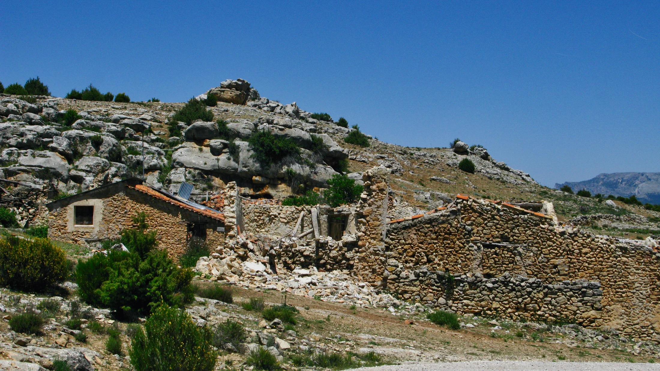
5.Ochate: Ruins And Stories In Burgos
Ochate lies in Condado de Treviño (Burgos province), an enclave surrounded by Álava, with a tall tower and scattered farm remains drawing both history buffs and folklore fans. The site’s “mystery” long predates the internet, but the lived story is rural abandonment and stone weathering in place. Dry grass brushes your shins like whispering fingers.
- What to see: the tower remains, church traces, and low walls that sketch former streets; surrounding fields open wide views.
- Access: approach by local roads and a short track; no services on site.
- Best time: late afternoon for cross-light on stone; 45–90 minutes.
Practical notes:
- Private plots and active farms surround the area; park considerately and stick to tracks.
- Combine with nearby villages in Álava for a meal and to ask about road conditions in wet weather.
- Bring a windproof layer—exposed ground accelerates weather changes even on sunny days.
6.Escó: A Reservoir-evacuated Hilltop In Zaragoza
Escó stands above the Yesa reservoir near the Aragón–Navarra border, a hilltop village largely emptied during expropriations linked to the dam. From below, the ruined silhouette and remaining church tower set a haunting profile against the water. The air smells faintly of straw and damp stone by the shore.
- What to see: church remains, clustered houses in various states, and broad views over the reservoir and Pyrenean foothills.
- Access: approach by
N-240/A-21corridors then local roads; some sections are rough but passable in dry weather. - Best time: spring for gentler temperatures; 1–2 hours.
Practical notes:
- Mind erosion around edges and avoid walking near steep drops where stone has slumped.
- Check for any local advisories; works around the reservoir can temporarily affect access.
- Pair with a visit to living towns like Sangüesa or Sos del Rey Católico for services and heritage centers.
7.Búbal: Between Memory And Reconstruction In Huesca
In Tena Valley, Búbal was partially evacuated by the reservoir that bears its name and later saw educational restoration work that stabilized several structures. You can read layers here: abandoned walls, taught craft techniques, and the modern life of a high mountain valley with year‑round activity. Pines send a clean resin scent after afternoon showers.
- What to see: reconstructed houses, a small interpretation of village life, and lake views; the wider valley offers trails and viewpoints.
- Access: main valley road
A-136with easy parking areas; short walks within the village. - Best time: shoulder seasons for quiet; 1–2 hours, plus a half-day hike nearby.
Practical notes:
- Consider staying in the valley and pairing your visit with mountain routes on
GRsegments or lakeside paths. - Ask locally about current access to any buildings; programs change seasonally.
- Book family-friendly rural accommodation in the valley to connect this stop to broader rural tourism Spain plans.
8.Mediano: A Sunken Village In Sobrarbe, Huesca
Mediano lies under the Cinca’s Mediano reservoir; when levels drop, parts of the village emerge, and the bell tower—often visible—cuts a stark figure in blue water. From higher viewpoints like the area near Samitier, you can safely appreciate the setting without approaching unstable shorelines. The tower’s reflection trembles like a metronome on the skin of the lake.
- What to see: the bell tower in the reservoir, and, at very low levels, foundations and streets.
- Access: drive the
A-138between Aínsa and Lafortunada; stop at signed viewpoints and avoid unauthorized shore access. - Best time: late summer or drought periods; 30–60 minutes for viewpoints, longer if you picnic.
Practical notes:
- Do not attempt to enter exposed structures; reservoir edges are deceptive and can slump.
- Respect posted rules from the river basin authority; water levels can change within hours.
- Bring binoculars for safe, distant detail and a telephoto lens if you want tighter frames.
9.Sant Romà de Sau: The Reappearing Bell Tower In Catalonia
At the Sau reservoir (Osona), the bell tower of Sant Romà de Sau surfaces dramatically when levels fall, making it one of Catalonia’s most photographed symbols of the hydraulic century. The surrounding Guilleries–Savassona landscape invites calm walking and quiet, respectful contemplation. In the evening, swallows trace dark seams over the pale water.
- What to see: the bell tower from shore viewpoints; at extreme lows, broader remains appear but often with restricted access.
- Access: approach by
C-25and local roads toward Vilanova de Sau; viewpoint parking areas are signposted. - Best time: winter and early spring often bring lower levels and clear air; 45–90 minutes.
Practical notes:
- Local authorities may prohibit walking on the exposed lakebed for safety and heritage protection—respect these rules.
- Combine with signed trails in the natural area and lunch in nearby villages to support local economy.
- Drones are regulated; consult national aviation rules and park-specific restrictions before any flight.
10.Valdelavilla: A Recovered Hamlet In Soria
Valdelavilla, in Soria, moved from abandonment to careful recovery, showing how rural fabric can be reused with respect. Stone houses now host stays and cultural programs, and the hamlet’s layout remains legible and human-scaled. The scent of woodsmoke at dusk slips between slate roofs.
- What to see: restored streets, vernacular architecture, and the surrounding oak and pine landscapes of the Iberian System.
- Access: local roads lead close; park at designated areas and explore on foot.
- Best time: all year; spring wildflowers and autumn colors are especially fine; plan 1–2 hours, more if staying overnight.
Practical notes:
- Book accommodation in advance if you want to sleep among these stones; weekends fill early.
- This is a living recovery project—respect privacy where signed, and favor local food and activities in the area.
- Fold Valdelavilla into a mellow weekend circuit of Soria’s villages to deepen your rural tourism Spain experience.
11.Tiermas: Hot Springs And A Vanished Spa In Navarra
Tiermas, on the shores of the Yesa reservoir, was evacuated for the dam, and parts of the old spa and streets reappear when water is low. The remains recall a golden age of bathing culture and the shock of loss when the valley filled. Warm mineral scent rides the air in drought years near the old springs.
- What to see: foundations of the spa complex, street traces, and church remains at very low levels; views from higher ground when water is high.
- Access: approach from
N-240/A-21; vantage points allow safe observation even if the shoreline is off-limits. - Best time: late summer or during marked drawdowns; 45–90 minutes.
Practical notes:
- Access to the old spa area depends on water level and safety orders; always check local notices and obey closures.
- Do not bathe in exposed pools; surfaces are slippery and fragile.
- Combine with nearby living villages for services, and consider a loop including Escó and Ruesta for a full day.
12.Poble Vell De Corbera D’ebre: Memory On A Hill In Terra Alta
Near Gandesa (Tarragona), the Poble Vell de Corbera d’Ebre preserves streets and the church shell as a space of remembrance for the Battle of the Ebro. Visits often include an interpretation of the site’s meaning and support local stewardship. In late light, dust hangs golden in the nave like incense.
- What to see: church ruins, lanes with explanatory panels, and viewpoints over the vineyards and sierras of Terra Alta.
- Access: paved approach and signed entry; donations or tickets support conservation and interpretation.
- Best time: spring and autumn for soft light and vineyard color; 1–2 hours.
Practical notes:
- Follow marked paths; do not enter unstable interiors or climb walls for photos.
- Pair your visit with wineries or rural stays in the region to return value to the community.
- From Barcelona, it’s roughly a 2–2.5 hour drive via
AP-7/C-12; plan a day trip or a quiet weekend.
Getting There, Getting Around, And Where To Stay
A car gives you the most flexibility to reach scattered sites and adjust to weather or water levels. Build your route around main corridors—AP-68 for the Ebro, A-23/A-21 toward Aragón and Navarra, C-25 across Catalonia, or A-66 in Extremadura—and then branch onto secondary roads. Expect 15–40 minutes on local roads for the last stretch; slow down for tractors and sheep, and you’ll arrive with less stress.
Public transport can still get you near several starting points:
- Trains or buses to provincial hubs (Zaragoza, Huesca, Lleida, Soria, Ourense).
- Regional buses to smaller towns nearby.
- Taxi or pre-booked transfer for the final 10–25 km, especially where services are sparse.
Ridesharing makes sense for weekenders: arrange pick-up at a rail station and split the last leg. If you navigate by phone, download offline tiles for dead zones and mark essentials in advance (fuel, food, pharmacy). On rural tracks, keep an eye on weather; heavy rain can rill surfaces and create sudden channels. If a track looks too rough, park lower and walk the last kilometer.
Staying nearby multiplies the quality of your experience:
- Rural houses and small inns in living villages let you arrive at first light, meet neighbors, and hear stories.
- Campgrounds and mountain hostels in Pyrenean valleys make great bases for Mediano and Búbal.
- Paradores or simple guesthouses near heritage towns add comfort within short drives.
Practical planning tips:
- Cluster 2–3 sites within a 60–90 minute drive loop instead of racing across regions.
- Check opening times for guided or gated sites the day before (e.g., Belchite old town and Granadilla).
- Carry cash for small-town cafés and donations; many places still operate simply.
- Keep a modest kit in the car: water, snacks, headlamp, first-aid pocket kit, and a high-visibility vest in case you park on a shoulder.
Link your stay to experiences that support the territory. Browse nature walks, vineyard visits, or family-friendly outdoor activities, and consider booking through Picuco’s curated listings to keep your rural tourism Spain plan both simple and locally grounded. In the end, getting there is part of being there: windows down, a slow gear, and a wave to the shepherd.
What To Do There, And How To Do It Well
These places reward slow observation. Photography thrives on textures, oblique light, and honest angles—use a tripod at dusk or dawn, shoot from public paths, and resist staging or moving objects. Short hikes connect many sites with lookouts or living villages; pair 30–60 minutes on-site with an hour’s loop on a marked path nearby. From time to time, local associations host memory events or volunteer clean-ups—ask in the nearest town hall or cultural center.
Safety and permissions are not optional:
- Do not enter buildings; roofs and floors fail without warning.
- Obey “no entry” signs, fences, and any instructions from guides or maintenance staff.
- Reservoir edges change shape; follow river basin rules and keep children close.
- Drones require pilot licensing and airspace checks; natural parks and town halls publish restrictions—when in doubt, don’t fly.
Pack for self-reliance:
- Footwear: grippy hikers; avoid sandals.
- Clothing: layers, hat, and a rain shell.
- Essentials: 1–2 liters of water per person, snacks, a first-aid pocket kit, and a headlamp if you stay to last light.
- Navigation: offline maps and a charged phone; a paper map adds redundancy in mountain areas.
Ethics of the image and the post:
- Avoid geotagging fragile corners with exact coordinates; name the general area instead.
- Do not share unsafe behavior (roof walks, wall climbs)—it encourages copycats and damages places.
- Never collect artifacts or “clean” a scene by moving objects; every piece in situ is part of the site’s story.
One sensory moment anchors the day: olive leaves rattling in a side wind as a distant tractor hums, while you frame a doorway that once held a family’s winter sun. Keep that humility in your steps; it’s the simplest way to give back. And if you want to extend the experience, choose activities that connect the visit—a farm lunch, a guided nature walk, or a small museum in the next village.
Frequently Asked Questions
Do I need permission to visit these villages?
Often you can walk public streets without a permit, but some sites operate by guided visit only (e.g., Belchite pueblo viejo) or are closed at certain times. Check municipal or heritage pages the day before.
Can I enter buildings for photos?
No. It’s unsafe and often illegal; roofs, floors, and lintels can fail suddenly. Photograph from streets, lookouts, and open areas, and follow any taped-off zones.
When is the best time to go?
Spring and autumn bring mild weather and low vegetation; winter gives clear air and long shadows. For reservoir sites like Mediano or Sant Romà de Sau, low water in late summer or drought periods improves visibility—verify current levels.
Are these visits suitable for children or dogs?
Short, open-air visits can suit older children if you supervise closely and avoid edges, wells, and buildings. Keep dogs leashed around livestock and cliffs; many areas require it by local ordinance.
What about drones and social media?
Drones are regulated; check airspace, park rules, and municipal restrictions. On social media, avoid promoting risky behavior or precise geotags for fragile spots; share context and respect instead.
How do I find Granadilla visiting hours?
Hours vary by season and are published by the regional administration; look up the latest schedule before driving, and remember that closures for fire risk or holidays may apply.
Book your experience — discover outdoor and nature activities across Spain with providers curated by Picuco.
Conclusion
Abandoned villages Spain are not theme parks; they are open pages in a long book of land, work, loss, and care. Visit with patience, follow local rules, and pair each stop with time and spending in nearby living villages to honor the communities that keep these places accessible. Next steps are simple: check the map above, confirm guided times where required (like Belchite old town and Granadilla visiting hours), and choose a rural stay to turn a drive into a weekend. If this guide helped you, share it with someone who travels thoughtfully, and tell us what you discovered—your story might help protect the next village you visit.