Why Walk Spain’s Ancient Paths?
Seek out the Roman roads Spain still hides in plain sight, and you’ll touch history with every step. These ancient paths—cañadas reales for transhumance, imperial calzadas romanas for trade, and layered historic routes—thread landscapes and communities that shaped the Iberian Peninsula. You walk not just a line on a map, but a living corridor of memory and use.
For families, couples, and curious travelers, they offer a rare mix: open dehesa pastures, silent milestones, medieval bridges, and villages where seasonal herds still set the calendar. Picture the dust lifting from hooves at dawn while larks rise above a holm oak ridge. Along these trails, heritage is active and grounded in the people who keep it.
This guide gives you clear orientation: short histories, how each network formed, and what to look for—from miliario (Roman milestone) to abrevadero (watering place). You’ll find eight representative routes with practical segments to hike or cycle, how to locate them on official maps, when to go, and how to travel there sustainably. We add safety and conservation advice so your visit strengthens, rather than strains, the places you pass through.
Spain’s drovers’ roads, or drovers' roads in English, remain legally protected corridors up to 75 meters wide, and many Roman alignments are documented by archaeology and protected as cultural heritage. The facts are tangible: Law 3/1995 safeguards the national network of vías pecuarias, the Camino de Santiago is UNESCO-listed, and the modern Ruta Vía de la Plata follows a Roman backbone north–south. Lace your boots for ancient paths Spain still breathes through, and you’ll gain history you can see, touch, and cross from stage to stage.
Picuco te puede ayudar
Does something here catch your eye?
Tell us.
Write to us on WhatsApp or email: we answer questions, find the best options and help you sort out the booking.
What Cañadas Reales, Roman Roads, and Historic Trails Really Are
Start with function, because use shaped every path you’ll walk. Cañadas reales are broad livestock corridors created for trashumancia, the seasonal movement of herds between summer and winter pastures to avoid heat or snow. They form the widest tier of Spain’s vías pecuarias (drovers’ roads), which also include cordeles and veredas. A single line of sheep bells at dusk, soft as rain on stone, tells you these routes still serve their original purpose in places.
Widths are not folklore; they are defined in law. By law (Spain’s Law 3/1995), a cañada is 90 varas castellanas, about 75.22 m; a cordel is 45 varas, about 37.61 m; and a vereda is 25 varas, about 20.89 m. Many retain traditional elements: abrevaderos (watering ponds), descansaderos (resting areas), and puentes pecuarios (livestock bridges). The Ministry for the Ecological Transition (MITECO) and regional governments catalogue and protect them, and the national network exceeds 100,000 km of classified corridors.
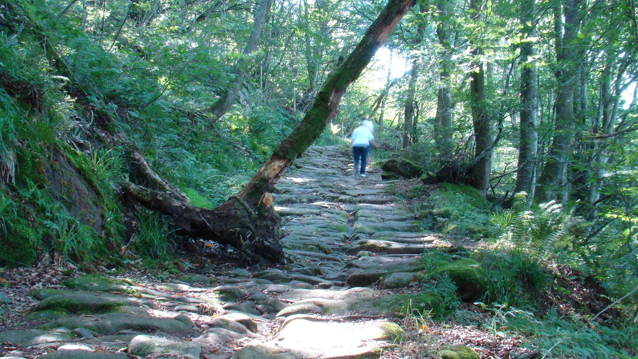
Roman roads—calzadas romanas—were engineered arteries for the empire’s logistics, moving troops, goods, and ideas. They used layered construction (foundations of stones, compacted gravel, and a cambered surface where needed) and were waymarked by miliarios, stone pillars typically spaced every Roman mile (about 1.48 km). Terms to know: miliario (milestone), mansio (staging post), and statio (smaller station). In Spain, scholars estimate thousands of kilometers of Roman routes once knit Hispania together, with the Vía de la Plata and Vía Augusta among the most documented. Many segments are protected as Bienes de Interés Cultural (BIC) under regional heritage laws.
Historic trails is a broader umbrella for medieval roads, local trade paths, cultural itineraries, pilgrim ways, and surviving pastoral paths beyond the main cañadas. Think the Camino de Santiago network, the Camino del Cid’s literary geography, or cobbled lanes linking villages to weekly markets. You may see beaterios mentioned in archives—religious houses for devout laywomen that sometimes offered hospitality—showing how infrastructure and care networks accompanied travel.
Together, these paths configured Spain’s landscapes. They align passes, river fords, and dehesas; they explain why towns cluster where they do; and they carry intangible heritage—festivals when herds pass, prayers at wayside crosses, and craft traditions still practiced. Today, protection varies. Cañadas fall under Law 3/1995 and regional regulations; Camino de Santiago routes are UNESCO World Heritage (main listing 1993, extensions later); many Roman sections and medieval bridges enjoy BIC status; and some corridors have been restored as Caminos Naturales or converted to Vías Verdes on disused railbeds.
For you as a visitor, clarity matters. Historic designation doesn’t always mean field signage, so you’ll rely on official mapping (IGN), regional heritage portals, and on-the-ground waymarks. Where herds still move, you are a guest on an active road, and that living use is precisely the value you’ve come to witness.
Eight Landmark Routes You Can Follow Today
Cañada Real Leonesa Occidental: Northbound Backbone Of Transhumance
Follow a north–south spine that once moved thousands of Merino sheep between Extremadura’s winter dehesas and the summer grasslands of León and Asturias. The Cañada Real Leonesa Occidental crosses provinces like Badajoz, Cáceres, Salamanca, Zamora, and León, threading cork oak groves, cereal plains, and river corridors. You can locate classic segments near 40.137°N, -6.105°W (north of Plasencia) where paths widen to their full 75 m legal width.
This route epitomizes cañadas reales: broad corridors with abrevaderos, stone pens, and old toll points that speak of pastoral economies linked to the Mesta, the medieval guild regulating transhumance. At dawn, dew beads on thyme and sheep lanolin scents the cool air. Walkers find historic hiking on easy, mostly flat tracks; birders watch kites, cranes (in winter), and bustards.
- Representative sections: Plasencia–Caparra area (Cáceres); Sanabria basin (Zamora).
- Access: Train to Plasencia or Salamanca; local buses to trailheads; ample rural road parking.
- Why go: Landscape literacy—this path explains Spain’s dehesa and the rhythms of movement.
- Map tip: Use IGN’s TopoEspaña and regional
vías pecuariaslayers to see legal corridors.
Cañada Real Soriana Occidental: Between Plateaus And Sierras
This western Soriana axis links Castile’s mesetas to systems like Gredos and Guadarrama, allowing flocks to climb in summer and return before snow. It crosses Soria, Burgos, Segovia, Ávila, Salamanca, and Cáceres, touching villages where herding still marks the calendar. Expect granite walls, stone bridges, and way stations that tell of paused nights and counted animals.
The path’s cultural density is high: troughs engraved with dates, cobbled fords, and vernacular shelters. Under a July sky, cicadas build a steady hiss in the broom thickets. Many sections suit day walks on gentle gradients, with longer multi-day links between towns. For local context, look to transhumance associations and municipal cultural centers that interpret the route.
- Walkable stretches:
Veredalinks near41.768°N, -3.066°W(southern Burgos); foot-friendly lanes in northern Ávila. - Heritage along the way: watering places, medieval bridges, and small sanctuaries.
- Access: Trains to Soria, Segovia, or Ávila; regional buses to rural stops; car access via N-110 and secondary roads.
- Why go: Classic Castilian landscapes and living pastoral memory on an authentic cañada.
Cañada Real de la Plata: Tradition And Historic Connections
Named for “plata” not because of silver mines but likely for the polished, packed surface of a major route, this cañada parallels and sometimes coincides with the Roman Vía de la Plata corridor. It links Andalusia with Extremadura and Salamanca before heading north, offering a continuous livestock corridor that sometimes overlaps cultural itineraries.
You can walk oak-dotted dehesa near Zafra and Llerena (Badajoz), pass by Roman and Visigothic traces in the Cáceres province, and reach Salamanca’s cereal plains. A warm breeze smells of dry grass and acorns beneath low, spreading holm oaks. Hikers meet wide tracks, cyclists find gravel-friendly surfaces, and history buffs can detour to milestones and bridges.
- Where to go: Zafra–Llerena section; Cáceres–Casar de Cáceres corridor; fields south of Salamanca.
- Connections: Convergences with the
GR-100(Ruta Vía de la Plata) in Extremadura. - Access: Renfe services to Zafra, Mérida, Cáceres, and Salamanca; good secondary roads for car drop-offs.
- Why go: A cross-section of southern agro-pastoral Spain that dovetails with Roman heritage.
Cañada Real de las Merinas: Sheep Country And Local Memory
Merino sheep gave Spain fine wool and a global reputation; this cañada keeps that lineage visible. It weaves through central Spain—Segovia, Ávila, and neighboring provinces—linking summer grasslands to sheltered winter grounds with a particular focus on ovine culture. Expect majadas (sheepfolds), small chapels used in seasonal rites, and village festivals marking the passing herds.
Here, local life and memory are the main attraction, with fairs and guided transhumance walks in spring and autumn organized by town councils or cultural groups. In late afternoon, dust motes drift golden in slanting light as bells tinkle past a stone cross. On foot, you’ll cover easy, family-friendly distances; on a bike, gravel tires are perfect.
- Good bases: Pedraza and Sepúlveda (Segovia), Navarredonda and El Barco de Ávila (Ávila).
- When to go: Spring and autumn for pastures and community events tied to
trashumancia. - Access: Trains to Segovia and Ávila; rental cars for rural connectors; weekend buses from Madrid to gateway towns.
- Why go: Walk into living heritage, not a museum—learn how herds shape calendars and cuisine.
Vía de la Plata (roman Road): A Calzada With Many Lives
As a Roman road, the Vía de la Plata historically ran from Emerita Augusta (Mérida) to Asturica Augusta (Astorga), roughly 470–490 km, with documented miliarios and stations. The modern long-distance itinerary extends from Sevilla to Gijón (about 800–900 km depending on variant), blending Roman alignments with medieval and later roads. Archaeology meets big skies here.
Key Roman remains include the four-way arch at Caparra 40.137°N, -6.105°W, milestones scattered along Cáceres province, and bridges like Alconétar’s site. The scent of warm thyme and sun-baked stone rises from the verge. Hikers and cyclists can follow well-marked GR-100 sections in Extremadura, mixing cultural stops with dehesa and reservoir vistas.
- Recommended segments: Mérida–Alcuéscar (Roman remains + easy walking), Cáparra–Aldeanueva del Camino (milestones, arch), Salamanca–Zamora (river plains).
- Bike notes: Rolling terrain suits touring bikes with 35–45 mm tires; summer heat requires early starts.
- Sources: Instituto Geográfico Nacional (IGN), Extremadura’s heritage inventory, and provincial archaeology guides.
- Why go: A rare route where you can literally count history in stone mile by mile.
Vía Augusta (roman Road): The Mediterranean Artery
Vía Augusta traced the Mediterranean seaboard from the Pyrenees to Cádiz, exceeding 1,500 km in its Roman extent and connecting ports, villas, and cities. Today you can identify segments near Tarragona, Valencia, Castellón, and Andalusian provinces, with milestones, causeways, and bridges protected under regional heritage lists. You travel a coastal corridor of commerce millennia old.
Near Tarragona, the Pont del Diable aqueduct 41.148°N, 1.190°E and documented milestones show the Roman footprint; farther south, alignments parallel modern roads and farm tracks. Sea breeze lifts the scent of pine and salt as you step onto a fragment of paved causeway. Given urbanization, expect discontinuous sections—ideal for short historic walks combined with museum visits.
- Where to explore: Tarragona hinterland (milestones, aqueduct), Elche–Orihuela corridors (identified alignments), Baetica approaches toward Cádiz.
- How to do it: Combine city rail hubs with short bus/taxi hops to rural segments; walk or cycle short loops.
- Respect: Many sections are sensitive archaeological areas—stay on marked paths and avoid artifact collecting.
- Why go: It’s the Roman coast road distilled—history in patches that still make narrative sense.
Camino de Santiago (camino Francés): A Living Pilgrim Way
The Camino Francés crosses the Pyrenees at Roncesvalles, runs via Pamplona, Logroño, Burgos, and León, and crests at the Cruz de Ferro 42.559°N, -6.420°W before reaching Santiago. UNESCO World Heritage status recognizes layers of architecture and intangible tradition: hospitals, bridges, monasteries, and the ritual of hospitality. You walk a path that renewed itself every year for a thousand years.
This is a historic trail, not a cañada, though in places it follows older Roman or local roads. At dawn, church bells carry across barley fields and the smell of fresh bread from albergue kitchens. Infrastructure supports all levels of walkers and cyclists, with clear waymarking, daily services, and albergues in most stages.
- Classic stages: Roncesvalles–Zubiri (mountain woodland), Burgos–Hornillos (open meseta), Astorga–Cruz de Ferro (high pass).
- Access: Major train/bus hubs at Pamplona, Logroño, Burgos, León; local transfers to stage starts.
- Why go: To experience a historic route Spain maintains as living culture—sharing stories with people from everywhere.
Camino del Cid: Medieval Itinerary And Narrative Landscape
Inspired by the epic of El Cid, this cultural route crosses Castilla y León, Aragón, Castilla–La Mancha, Comunidad Valenciana, and beyond, linking fortresses, walled towns, and frontier landscapes. It’s a modern, well-signposted itinerary using historic paths and quiet roads, with hiking, MTB, and road sections mapped stage by stage.
Tracts through the Sierra de Albarracín, the Jalón valley, and Moorish castles around Valencia bring the poem’s frontier to life. In limestone canyons, swallows stitch dark arcs across pale cliffs. The route offers GPX downloads, segment classifications, and services clustered in historic towns, making it a fine introduction to sendas históricas.
- Highlights: Albarracín–Calomarde ravines, Gallocanta lagoon, Daroca’s walls, Javalambre foothills.
- Surfaces: Mixed—farm tracks, singletrack, quiet tarmac; choose walking, gravel, or road variants.
- Access: Trains to Zaragoza, Teruel (limited), and Valencia; buses to smaller towns; self-drive to trailheads.
- Why go: Story-rich landscapes with practical, modern waymarking—history you can follow at your own pace.
Where They Are And How To Read The Map
Location And Interactive Mapping
These routes run across Spain’s spine and edges: cañadas reales crisscross Castile and Extremadura into León and Andalusia; Roman roads thread Extremadura, Castilla y León, the Mediterranean arc, and Andalusia; historic routes connect the Pyrenees to Galicia and the Levant. To locate a segment, start with the Instituto Geográfico Nacional (IGN) online viewer, add layers for vías pecuarias when available, and consult regional heritage maps for calzadas romanas.
Use topographic maps (MTN25 or MTN50) to visualize gradients and water points, and cross-check with hiking apps that include GR and PR trails. The key is layering: cañadas reales for transhumance trails, Roman alignments for archaeology, and marked cultural itineraries for wayfinding. If you use GIS, download shapefiles from regional vías pecuarias catalogs and overlay with IGN’s base maps.
Before you go, verify detours, closures, or seasonal restrictions on official portals, as active droving or conservation works may alter access. The smell of damp earth after a spring shower reminds you maps are living tools—update them with recent local notices. For personal wayfinding, carry an offline map plus a power bank as cell coverage can fade in dehesa and sierra.
Best Season And Weather Considerations
Spring and autumn are the sweet spots for most corridors: mild temperatures, green pastures, and active community calendars. Summer brings extreme heat on the meseta and in lowland Extremadura and Andalusia, pushing hikes to early morning or evening, while winter can load high passes on the Camino Francés with snow and ice.
Transhumance still happens in some provinces (often May–June and September–November), and you may meet herds occupying the full width of a cañada. The sound of bells in cool morning air signals you to step aside and let the movement flow. Check the Spanish Meteorological Agency (AEMET) forecasts for heat alerts, wind, and storms, and adapt plans—carry extra water in summer and warm layers for dawn chill in shoulder seasons.
For fiestas and fairs linked to herding, consult town council calendars; they enrich visits but can fill accommodations. If you hope to witness herds on the move, call local tourism offices a week ahead to ask about expected dates and crossings.
Getting There: Trains, Buses, And Car Access
Most major entry points are train-connected cities: Mérida, Cáceres, Salamanca, León, Burgos, Pamplona, Zaragoza, Valencia, Tarragona, Sevilla, and Cádiz. From there, regional buses or short taxi hops bring you to rural trailheads; always check weekend schedules, which can be sparse. For coastal Vía Augusta segments, commuter trains plus a final bus or taxi often work best.
If you drive, plan safe parking in villages, official lots, or at áreas recreativas (recreation areas) rather than roadside verges. Early starts help secure spots and beat heat. A simple strategy for linear day walks is to use two vehicles or to walk an out-and-back section on shaded stretches. Soft shoulders, golden stubble, and a low hum of insects welcome a return leg on a quiet farm track.
Sustainable mobility options—bike rentals at rail hubs, shared taxis in rural counties, and demand-responsive buses in some provinces—can stitch your itinerary together. Confirm local options at tourist offices, and carry cash for small-town taxis.
Sleeping And Services On The Way
You’ll find a spectrum of stays: pilgrim albergues on the Camino Francés; rural guesthouses and casas rurales near cañadas; historic inns in heritage towns on the Vía Augusta; and modest hotels in provincial centers along the Vía de la Plata. In remote stretches, plan spacing between villages to secure water and food; fountains are common but not guaranteed potable—carry a filter.
Core services to map ahead:
- Water points: fountains,
abrevaderos, village taps; assume dry in late summer unless verified. - Food: village bars, bakeries, weekly markets; carry extra on Sundays and fiestas.
- Bike support: workshops cluster in towns >5,000 inhabitants; carry tubeless sealant and a folding tire.
- Supplies: small supermarkets in county towns; pharmacies in most municipalities.
Reserve ahead in peak times—Easter, summer weekends, and harvest festivals. A pine-scented breeze through a patio at dusk is nicer with a booked bed than a last-minute scramble. To support local economies, choose family-run stays and eateries, and ask about seasonal events linked to trashumancia or heritage.
What To Do Along The Way: Activities And Highlights
The richness of these corridors lies in layered experiences you can fold into a single day. Start with archaeology: on Roman roads, look for miliarios (often re-used as fence posts), foundations of causeways, and bridges at river crossings. Museums in Mérida, Tarragona, León, and provincial towns interpret finds from their territories, helping you read stones in the field—walk a track, then stand before a labeled milestone to match reality to text. The smell of old limestone in a cool gallery deepens what you saw under sun.
On cañadas reales, ethnography is center stage. Abrevaderos still water herds, and descansaderos double as picnic lawns. Some municipalities host transhumance fairs, shearing demonstrations, and guided walks led by herders in spring or autumn. Ask town halls or county tourism boards for dates, as these are rarely mass-advertised but warmly local.
Nature watching is superb because corridors cross habitat mosaics. In dehesa, scan for Iberian magpies, black vultures, and seasonal cranes; in Mediterranean scrub by the Vía Augusta, expect bee-eaters and hoopoes; on the Camino Francés meseta, larks and harriers quarter fields. Carry binoculars and respect distances in nesting season; dawn and late afternoon are best. A field of thyme releases a minty-spicy scent with each bootfall.
Food anchors memory. Pair hiking a Roman road with Roman-inspired dishes interpreted by local chefs, or simply savor shepherd staples: rustic bread, sheep’s milk cheeses, grilled lamb, and local olive oils. In León and Burgos, hearty stews fit cooler days on the Camino; in Extremadura, migas and Iberian pork echo dehesa life; by the coast, Vía Augusta days end with rice dishes or grilled fish.
For deeper context, seek:
- Interpretation centers focused on
trashumanciaandvías pecuarias. - Local archives or guided visits to Roman sites along Vía de la Plata or Vía Augusta.
- Workshops with artisans—wool, leather, or metalwork—whose crafts rode these roads.
- Community walks where residents recount place names, stories, and land use shifts.
Differences by path type matter:
- Cañadas reales excel in open, family-friendly walking, birding, and seasonal culture.
- Calzadas romanas deliver discrete archaeological highlights, short feature walks, and museum pairings.
- Historic sendas (Camino, Cid) offer complete service chains for multi-day trekking or cycling with cultural density each evening.
Anchoring each day with one sensory focus, one historic find, and one local conversation turns a line on the map into a lived journey.
Itineraries And Levels: On Foot, By Bike, And By Car
Walking Routes: Historic Hiking Made Simple
For historic hiking—senderismo histórico—choose well-defined stages with clear services. On the GR-100 (Ruta Vía de la Plata) in Extremadura, try:
- Mérida to Alcuéscar: 20–22 km, +150 m total ascent, 5–6 hours; Roman remains in Mérida, dehesa tracks midstage.
- Cáparra to Aldeanueva del Camino: 17–19 km, +120 m, 4.5–5.5 hours; pass the Caparra arch and find scattered
miliarios.
On cañadas reales, stages around Segovia or Ávila can be 12–18 km with minimal ascent—perfect for families:
- Pedraza loop on the Cañada Real de las Merinas: 14 km, +200 m, 4–5 hours; sheepfolds and viewpoints.
- Near Sanabria on the Cañada Real Leonesa Occidental: 16 km, +250 m, 4.5–5 hours; lakes and pastures.
Follow modern waymarking where it exists: red-and-white for GR paths, arrows on the Camino Francés, and local vías pecuarias panels at some access points. Where signage is sparse, orient with IGN maps and GPS tracks (GPX) from official portals. A faint smell of wild fennel crushed underfoot keeps you mindful and present.
Tips:
- Footwear: light boots with grip for gravel and cobbles; avoid slick soles on old stone.
- Water: 2–3 liters per person in warm months; treat village fountains unless labeled potable.
- Sun and wind: brimmed hat and wind layer even in spring; weather swings on open plains.
- Courtesy: yield to herds; speak calmly to stock guardian dogs; close gates as found.
Cycling Routes: Gravel, Mtb, And Greenways
Cyclists can stitch historic corridors with Vías Verdes (rail-trail greenways) and quiet tracks. On the Vía de la Plata corridor, rolling dehesa makes classic gravel terrain:
- Cáceres to Carcaboso via Caparra: 65–75 km in a day, mixed gravel/tarmac, moderate; archaeological stops; water in villages.
- Salamanca to Zamora: 65–70 km, mostly easy gradients; river crossings on historic bridges.
On the Camino del Cid, official MTB tracks offer graded difficulty and downloadable GPX; choose segments like Molina de Aragón–Albarracín (technical in parts) or easier Jalón valley stages. The Vía Augusta areas around Tarragona pair short archaeological spurs with coastal Vías Verdes for relaxed day rides. The click of a freehub on a shaded lane punctuates a drowsy afternoon.
- Bike choice: gravel (38–50 mm tires) for mixed surfaces; hardtail MTB for rocky farm roads; touring setups on Camino Francés or flatter Vía de la Plata days.
- Support: Larger towns host bike shops; carry multitool, chain link, plugs for tubeless, and a derailleur hanger.
- Transport: Most medium-distance trains allow bikes with conditions; check operator rules and avoid rush hours.
Integrate context stops: museums at midday heat, milestones at mile 20, and a local cheese tasting before your final roll into town.
Scenic Drives: Panoramas And Pinpoint Stops
If you travel by car, use roads that parallel historic corridors and schedule short on-foot detours to key sites. A 2–3 day drive along the Vía de la Plata axis can link Sevilla–Mérida–Cáparra–Salamanca–Zamora–León, with 30–90 minute walks at Caparra 40.137°N, -6.105°W and on signed dehesa tracks. Another loop around Segovia and Ávila touches the Cañada Real de las Merinas at village edges for easy heritage strolls.
On the Mediterranean side, a day in Tarraco (Tarragona) plus short rural drives to miliarios and the Pont del Diable makes a compact Vía Augusta intro. Keep your windows down on a farm road and catch the resin-sweet scent of pines. Balance driving with:
- 2–3 short hikes per day (1–4 km) to cobbled fords, bridges, or Roman paving.
- Town pauses for interpretation centers, local food, and artisan visits.
- Early and late light at viewpoints; midday for museums and siestas.
Safety and respect still guide your steps: park only in designated pullouts, never block farm accesses, and avoid driving on the bed of a vía pecuaria unless signed as a public track.
Smart Advice: Signs, Permits, Safety, And Care
Signage And Orientation On Cañadas And Calzadas
Expect mixed waymarking. Cañadas reales are legal corridors, not always trail-signed; look for information panels at some entries, painted posts marking vías pecuarias, and wide grassy or dirt swaths through farmland. Roman roads are usually indicated at specific archaeological sites—miliarios, bridges, and short conserved stretches—often with heritage plaques.
Where signage is absent, navigate by:
- IGN topo maps (
MTN25/50) and the official mobile viewer. - GPX tracks from regional portals (e.g.,
GR-100for Vía de la Plata). - Local advice from town halls and shepherds who know the lines.
If you encounter missing or damaged signs, document with a photo and GPS point and report to the municipality or provincial environment office. A whisper of wind through dry grass helps you hear your inner compass—confirm it with the map in your hand.
Permits, Rules, And Respecting Transhumance
Rights of way on vías pecuarias generally allow passage on foot, bike, and horseback, but activities like organized races, large group hikes, or vehicle access may require permits from regional environment departments. Wild camping is tightly regulated and often prohibited; opt for official campsites or ask landowners when appropriate.
During trashumancia seasons, herds have priority. Step off the main line, keep dogs leashed and well away from stock, and wait quietly as animals pass. For events (fairs, shearing, guided herd crossings), contact town halls or county cultural departments a week or two in advance. For protected archaeological sites on Roman roads, never remove artifacts and stay within marked zones—digging, collecting, or metal detecting is illegal and harms shared heritage.
Keep a copy of regional rules on your phone and a simple summary on paper; local police or agentes medioambientales appreciate informed visitors.
Safety, Gear, And Conservation On The Trail
Open country demands basic field sense. Carry:
- Navigation: map app + offline tiles, backup paper map, and a compass.
- Essentials: 2–3 liters of water (more in summer), sun protection, hat, wind layer, small first-aid kit, and a phone power bank.
- Footing: grippy shoes for cobbles and loose gravel; trekking poles for long days.
Around livestock, move calmly, give wide berth, and avoid sudden gestures. If guardian dogs approach, stand still, speak low, and let them assess; the shepherd will call them off. The cool shade of a holm oak is a good place to pause and reset before continuing.
Practice Leave No Trace:
- Pack out all waste, including organics; avoid lighting fires; stick to existing tracks.
- Respect rest times in bird breeding seasons—observe distance rules at wetlands like Gallocanta.
- Join local conservation days if you can, from milestone cleanups to dry-stone wall workshops—ask at town halls or nature centers.
Frequently Asked Questions
What is a cañada real, and how is it different from a Roman road?
A cañada real is a legally protected livestock corridor—up to about 75 m wide—used for transhumance, the seasonal movement of herds. A Roman road (calzada romana) was an engineered imperial highway for moving troops, goods, and information. Cañadas are active rural corridors shaped by pastoral use; Roman roads are archaeological and historical infrastructures, sometimes still followed by modern routes.
Do I need permission to cross a cañada real?
For normal walking or cycling in small groups, you generally do not need a permit, as vías pecuarias are public rights of way under Law 3/1995. Large events, organized races, or vehicle access often require authorization from the regional environment department. Check with the local town hall (ayuntamiento) for specific local rules before planning group activities.
What is the best time of year to visit these routes?
Spring and autumn suit most segments: cooler temperatures, green pastures, and active village calendars. Summer is very hot on the meseta and in Extremadura/Andalusia; plan dawn or dusk outings. Winter can bring snow and ice to high Camino Francés passes. For transhumance events, ask town halls about expected dates in late spring and early autumn.
Can I ride these routes by bike?
Yes, many sections suit gravel or MTB: the Vía de la Plata corridor features rolling dehesa tracks; Camino del Cid offers mapped MTB stages with GPX; and coastal areas near the Vía Augusta pair short historic spurs with Vías Verdes. Use tires 38–50 mm for mixed terrain, carry repair gear, and respect archaeological sites—ride only on marked tracks.
Where do I sleep, and how do I plan stages?
On the Camino Francés, albergues and hostels appear almost every stage. Elsewhere, plan around rural inns and casas rurales in towns every 15–30 km. Reserve in peak seasons (Easter, summer weekends), carry enough water between villages, and check the IGN viewer plus local tourism websites for services. For day walks, pick out-and-back sections from villages with safe parking.
How do I find accurate maps of Roman roads and transhumance trails?
Combine the IGN online viewer (topographic base) with regional vías pecuarias catalogs and heritage inventories that mark Roman alignments and sites (miliarios, bridges). Official route websites for GR-100 (Ruta Vía de la Plata) and Camino del Cid offer GPX. Always verify closures or detours at town halls before heading out.
Book your experience — discover active travel in Spain with vetted providers on Picuco.
Conclusion
Spain’s cañadas reales and calzadas romanas are more than lines on old charts; they are working corridors and archaeological threads that still bind landscapes and people. You’ve seen how drovers’ roads keep trashumancia alive, how Roman milestones mark imperial logic, and how historic routes like the Camino Francés and Camino del Cid carry culture stage by stage. The faint ring of bells on open pasture and the cool heft of a stone bridge underfoot are your proofs.
Choose a route that suits your pace—short family loops on a cañada, a weekend riding the Vía de la Plata’s dehesa lanes, or a week stitching Vía Augusta segments with museum stops. Travel light, prepare well, and respect the land, the herds, and the heritage on your path. If this guide sparked ideas, explore curated experiences on Picuco to turn them into plans with local hosts who care for these places.
Walk with attention, greet the people who keep these roads alive, and leave each stretch better informed than when you arrived. On Spain’s ancient paths, every step can be a lesson and a promise—to carry this shared story forward with care.