Why Winter Hiking in Spain Is Worth Your Time
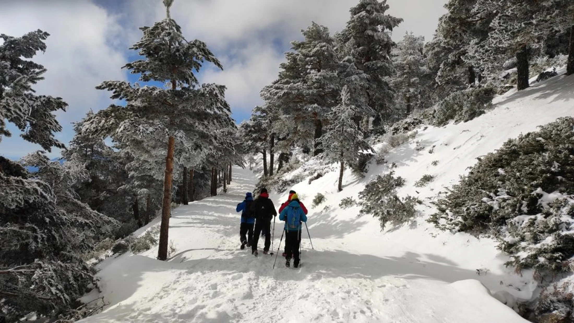
When temperatures fall and crowds thin, winter hiking Spain reveals quiet forests, sharp light, and mountains at ease. You’re here for dependable winter hiking routes Spain, and this list delivers varied terrain, clear logistics, and safety-forward choices. Expect a numbered selection across the Pyrenees, Picos de Europa, Central System, Sierra Nevada, Canary Islands, and a coastal escape in Almería. Frost glints on a beech leaf like glass held to the sun.
To choose these 10 winter trails Spain, we looked at five criteria: safe, well-defined routes in typical winter conditions; standout scenery; geographic and climate variety; reasonable access (parking or public transport); and suitability from family-friendly to advanced. You’ll find each trail presented as a compact mini-guide with where, how long, who it suits, winter-specific hazards, plus local tips like viewpoints, refuges, and milder alternatives nearby. Water murmurs below footbridges while cold air smells like wet stone.
What you’ll get today: a numbered list of 10 trails, a practical profile for each, an overview on difficulty and how to read route data, an interactive map concept you can embed, prep tips for hiking in snow Spain, and an FAQ focused on gear, dogs, permits, and avalanche basics. We write with the people of these valleys in mind—hoteliers, refuge wardens, and park rangers who keep paths and advice alive in the quiet months. A jay’s cry carries strangely far on clean winter air. Use these notes to plan, decide, and walk at your own pace—then consider booking local stays or guides to deepen your experience.
Picuco te puede ayudar
Does something here catch your eye?
Tell us.
Write to us on WhatsApp or email: we answer questions, find the best options and help you sort out the booking.
How to Read the Route Profiles and Pick Your Difficulty
Each trail profile highlights the essentials you need to plan and adapt to winter. Look for: location and access (car, bus, cable car), costs if relevant (parking or lift—confirm current prices), best winter window, who it suits, suggested itinerary, safety notes (ice, cornices, avalanches), and local advice (miradors, refuges, or warmer alternatives). A faint smell of pine sap lifts as sun warms the first bend.
We use simple difficulty labels with time ranges:
- Easy: 1.5–3 hours, ≤300 m ascent, good path, limited exposure.
- Moderate: 3–6 hours, 300–800 m ascent, some exposure or snow travel skills.
- Demanding: 6–9 hours or >800 m ascent, winter gear and experience required.
Technical terms appear in plain language. Crampons are metal spikes that strap to boots for steep, icy slopes; microspikes are lighter traction chains for hard-packed paths; snowshoes spread your weight to avoid sinking in soft snow. Choose routes by matching your experience, current weather and snow reports, and the gear you actually carry—not the gear you wish you had. Cold stone under your hand reminds you to respect shade, wind, and the short arc of winter light.
Ten Standout Winter Trails Across Spain
1) Ordesa to Cola de Caballo, Ordesa y Monte Perdido National Park
The classic path through the Ordesa Valley to Cola de Caballo waterfall turns cathedral-still in winter, with frozen spray and hushed beech woods. This is a mostly valley-floor route with gradual ascent and a few icy sections in shade that can require microspikes or light crampons. Sunlight filters through bare branches, silvering the Río Arazas like brushed steel.
- Where and access: Start at Pradera de Ordesa car park (Torla-Ordesa, Huesca). In winter (outside peak holidays), the access road usually opens to private cars; in heavy snow or ice it can close temporarily—check park updates.
- Route and time: Linear valley path via Gradas de Soaso to Cola de Caballo; 17–19 km round trip; 5–7 hours in winter pace; elevation gain ~500 m.
- Difficulty: Moderate in summer; moderate-to-demanding in winter if ice is widespread.
- Best winter window: Clear, stable days from December to March; avoid after heavy snowfall or during strong north winds.
- For whom: Fit hikers with winter basics; good for those seeking senderismo nieve España without technical alpine terrain.
- Safety: Expect icy plates on shaded rock steps, especially near waterfalls; carry microspikes and trekking poles. Watch for snow-loaded slopes off-trail; valley floor is generally low avalanche terrain, but keep distance from corniced edges.
- Highlights: Gradas de Soaso cascades, the amphitheater near Cola de Caballo, beech stands, and big walls like Tozal del Mallo.
- Local tip: If conditions look slick beyond Soaso, turn the day into a photo-and-cascades walk with turnaround at the Gradas. Rangers in Torla share current path conditions.
A hush settles where the last waterfall mist freezes into lace on the pathside grass.
2) The Picos de Europa Cares Trail: Puente Poncebos to Caín
The Picos de Europa Cares trail threads a spectacular gorge on a bench-cut path, ideal on cold, bright winter days when summer’s crowds vanish. The line runs 12 km one-way between Puente Poncebos (Asturias) and Caín (León) with tunnels, ledges, and huge limestone walls. A raven’s wing beats once and the echo lingers like a drum.
- Where and access: Start at Puente Poncebos (AS-264) or Caín (LE-2703). Parking at both ends; in winter, services are reduced.
- Route and time: 24 km round trip; 6–8.5 hours in winter with photo stops. Popular winter alternative: out-and-back from Poncebos to Los Collados viewpoint (shorter, sunnier section).
- Difficulty: Moderate; exposure in places with protected ledges; ice risk in shaded cuttings.
- Conditions: Expect damp rock, occasional verglas (thin, hard ice) in tunnels and north-facing corners, and gusty winds in the throat of the gorge.
- Transport: No regular winter shuttle between ends; organize a second car or taxi if doing the full traverse. No permits or fees required.
- Best winter window: Clear spells between cold fronts, typically December to March.
- For whom: Confident hikers comfortable with exposure on a good path; families can sample shorter sections from each end on stable days.
- Safety: Wear sticky-sole boots; microspikes help on icy patches. Start early; the gorge loses light quickly in winter.
- Highlights: Narrow ledges, blue-green Cares River, and winter clarity on limestone faces.
Frost fizzes underfoot in the first tunnel, and your breath shows white in the blue shade.
3) Puerto de Navacerrada to Bola del Mundo, Sierra de Guadarrama
Close to Madrid, the ridge to Bola del Mundo (2265 m, also called Alto de las Guarramillas) offers a brisk winter outing with skyline views and often hard-packed snow. From Puerto de Navacerrada (1858 m), follow the broad track along old ski runs to the summit installations. A windborne dusting skitters over crusted snow like sand on a beach.
- Where and access: Puerto de Navacerrada, 60–75 minutes by car from Madrid (A-6 + M-601). Public transport: Cercanías to Cercedilla, then bus
691to the pass (service varies in winter). - Route and time: 7–9 km round trip; 2.5–4 hours in winter; ~400 m ascent.
- Difficulty: Easy-to-moderate on a clear day; winter increases seriousness due to ice and wind.
- Best winter window: High-pressure days with light winds, typically December to March.
- For whom: Hikers building winter skills near Madrid; a fine introduction to rutas invernales España with care.
- Safety: Expect rime ice and strong gusts; carry microspikes or light crampons plus poles. Wind chill can drop well below 0°C—pack full layers and a face covering.
- Transport and costs: Bus fares typical of Madrid regional lines; parking fills fast on weekends—arrive early.
- Local tips: Extend to
PR-9spurs if snow is stable, or bail to pine woods below if the ridge ices. Mountain huts and cafés at the pass may have reduced winter hours.
On clear afternoons, the Sierra casts a long purple shadow toward the capital as lights flicker on below.
4) Laguna Grande de Gredos from the Plataforma, Sierra de Gredos
High, cold, and magnificent, the walk to Laguna Grande enters the cirque of Gredos where winter clings longest. From the Plataforma de Gredos (approx. 1750 m), climb past Los Barrerones to the frozen bowl at ~1940 m, hemmed in by Almanzor and granite towers. Air smells faintly of iron where the stream runs free under rimed boulders.
- Where and access: Plataforma de Gredos car park above Hoyos del Espino (Ávila). Limited parking; road closures possible after storms.
- Route and time: 14–16 km round trip; 5–7 hours in winter; ~650 m ascent. Out-and-back via Los Barrerones.
- Difficulty: Moderate-demanding in winter due to altitude, cold, and potential ice.
- Best winter window: Clear spells from January to March; spring snow persists into April.
- For whom: Fit hikers with winter gear; good progression toward alpine terrain without committing to summits.
- Safety: Snow often persists from Los Barrerones; avalanche risk exists on lee slopes of the cirque—keep to the beaten winter track and avoid loaded gullies. Crampons and axe may be required after freeze-thaw; snowshoes are helpful in soft snow.
- Logistics: Public transport reaches Hoyos del Espino; taxis may cover the final kilometers. Refugio Elola (by the lake) has variable opening—confirm status before relying on it.
- Highlights: The sculpted cirque, a mirror of ice under granite spires, and sunset glow on Almanzor.
The hiss of wind through the pass drops to a hush as you crest and the cirque opens like a great stone theatre.
5) Hoya de la Mora to Virgen de las Nieves, Sierra Nevada
Sierra Nevada delivers Spain’s southernmost high-snow ambience, and this short winter outing packs altitude and views without committing to big ascents. From Hoya de la Mora (~2500 m) above Pradollano, follow the Veleta road and waymarks to the Virgen de las Nieves statue on the ridge. The sun tastes warm but the wind bites quick and clean.
- Where and access: Drive or bus from Granada to Pradollano (40–60 min), then continue to Hoya de la Mora if road and parking are open; local shuttles/taxis run in season.
- Route and time: 5–8 km round trip; 2–3.5 hours; 250–400 m ascent depending on variant.
- Difficulty: Easy-to-moderate; altitude and wind increase effort.
- Best winter window: Clear windows between storms, December to March. Fresh snow days are great for snowshoeing.
- For whom: Families and first-time Sierra Nevada winter hike seekers; a primer in cold, sun, and wind at high altitude.
- Safety: Expect windslab patches and glazed snow; microspikes or snowshoes depending on surface. Sun intensity is high—use high-SPF sunscreen and glacier sunglasses to avoid snow blindness.
- Logistics and costs: Parking control varies; resort lift passes (if you choose gondolas from Pradollano for other routes) commonly cost 30–50 €—confirm current prices and hours.
- Highlights: Vast views to Mulhacén and Veleta, the high plateau feel, and crisp desert light meeting snow.
On still days, sound falls away and the snowfield looks like the deck of a white ship sailing above Granada.
6) Fuente Dé to El Cable Viewpoint, Picos de Europa
At Fuente Dé (Cantabria), a dramatic cable car launches you from valley floor to the high karst in four minutes, making big-mountain scenery accessible in winter. From the El Cable upper station, short waymarked paths lead to viewpoints and gentle traverses when conditions allow. The cable hum fades and the plateau’s quiet arrives like a blanket.
- Where and access: Fuente Dé (CA-185). By car from Potes (23 km); buses run seasonally—check winter schedules.
- Route and time: Cable car to El Cable (c. 1840 m), then 1–3 hour strolls to Mirador de El Cable and short spurs; add 2–3 hours if climbing on foot (steep, not advised in icy conditions).
- Difficulty: Easy-to-moderate near station in good conditions; higher traverses demand winter gear and experience.
- Best winter window: High-pressure days with low wind; the lift often closes in high winds—check status before travel.
- Costs: Return tickets typically around 20–23 € for adults; confirm current prices and first/last cabins.
- For whom: Photographers, families sampling rutas invernales España at altitude, and hikers wanting quick access to snowfields.
- Safety: Beware of cornices near edges and hard ice on beaten paths; microspikes and poles recommended. Watch for rapid weather changes—cloud can drop fast.
- Local tip: Combine with warm, short gorge walks lower down around Potes if the plateau is glazed with ice.
The snow squeaks under boots as ravens roll above the limestone gullies, their calls swallowed by wide air.
7) Laguna Negra de Urbión, Soria
A black-walled glacial cirque wrapped in pine and beech, Laguna Negra feels carved for winter. The approach from Vinuesa winds up to car parks whose access varies with snow; from the upper lot it’s a short ascent, from the lower it becomes a fuller day. The smell of resin hangs where sun strikes a fallen trunk.
- Where and access: From Vinuesa via
SO-830. In winter the barrier may be closed; park at a lower lot and hike the forest road. - Route and time: 5–6 km round trip from upper parking; 9–12 km if starting lower; 1.5–4 hours depending; modest ascent unless you climb to the mirador.
- Difficulty: Easy-to-moderate depending on start point; winter ice amplifies risk on steps and shorelines.
- Best winter window: December to March on clear days after storms settle.
- For whom: Families and photographers on calm days; hikers can extend to the
GR-86links or up toward Pico Urbión in advanced conditions. - Safety: Do not walk on the frozen lake—ice thickness is variable. Expect ice on wooden walkways and steps; carry microspikes. Watch for snow-loaded tree branches after fresh falls.
- Logistics and costs: In peak seasons there’s a parking fee and shuttle; in winter these often pause—confirm locally.
- Highlights: Near-vertical cirque walls, dark water, snowy pines, and a high balcony viewpoint.
Down by the shore, hoarfrost etches white lace on grass that bends but will not break.
8) Teide National Park: The Roques de García Circuit, Tenerife
When mainland summits storm, Tenerife offers a milder winter with crisp days around 2100 m and a lunar feel under Teide’s cone. The Roques de García circuit begins near the Parador and loops among lava towers with constant views of Pico del Teide. Sun warms black pumice and the air smells faintly of baked rock.
- Where and access: TF-21 road, parking by Mirador de La Ruleta/Parador de Cañadas del Teide. Buses from the coast run daily but with limited schedules.
- Route and time: 3.5–4.5 km loop; 1.5–2 hours; gentle undulations with short, steeper steps.
- Difficulty: Easy-to-moderate; altitude and sun exposure are the main factors.
- Best winter window: November to March with mostly stable weather; occasional frost or snow dustings at higher elevations.
- For whom: Hikers seeking a warm-ish winter alternative among rutas invernales España; families and geology lovers.
- Options and costs: Teide cable car to La Rambleta (3555 m) often costs around 38–45 € return; summit requires a free permit and can close in wind—confirm availability and conditions.
- Safety: Even here, winter sun is strong; carry water, wind layer, and sun protection. Trails are rocky—use grippy footwear.
- Highlights: Cathedral-like lava towers, sea-of-clouds days, and sunset color washing Teide’s flanks.
Late light turns the Roques gold while cool air slips down the pumice like water over stone.
9) Cabo de Gata Coastal Paths, Almería
For a truly gentle winter, Cabo de Gata’s volcanic coast delivers bright days, quiet beaches, and cliff-top paths. Link sandy coves between San José, Genoveses, and Mónsul, or tackle the Cerro del Fraile volcano slopes for broad bay views. Salt on the breeze mixes with thyme from scrub warmed by sun.
- Where and access: Drive from Almería (40–60 min) to San José or Las Negras; winter buses are limited—check schedules.
- Route and time: Pick-and-mix coastal segments: San José–Genoveses–Mónsul (10–12 km round trip; 3–4 hours), or shorter family-friendly out-and-backs.
- Difficulty: Easy-to-moderate; sandy and rocky paths with some cliff edges.
- Best winter window: November to March; mild and dry with occasional windy days.
- For whom: Families, birders near the salt pans, and hikers who prefer a temperate take on senderismo invierno España.
- Safety: Keep back from unstable cliff edges and watch for wave surges on rock shelves. Sun and wind dehydrate—carry water and use sunscreen, even in January.
- Logistics and costs: No permits; parking is usually free in winter; services in villages may keep reduced hours.
- Highlights: Fossilized dunes, turquoise coves, lighthouse viewpoints like Cabo de Gata and Mesa Roldán.
The sea hisses against black lava fingers while gulls wheel in bright, clean air.
10) The Poqueira Valley Villages, Alpujarras (granada)
Between 1000 and 1500 m, the white villages of Pampaneira, Bubión, and Capileira scatter on sunny slopes under Sierra Nevada’s snowline. Stitch them together on old mule tracks and GR-7 spurs, with options to climb toward acequias and miradors. Wood smoke threads the air and stone lanes shine after a light frost.
- Where and access: Bus or car from Granada to Pampaneira/Capileira (1.5–2 hours; several buses daily, winter schedules vary). Parking at village entries.
- Route and time: Village-to-village loop 8–12 km; 3–5 hours; 400–600 m ascent depending on variants. Add spurs to Tajo del Diablo or acequia paths if snow permits.
- Difficulty: Easy-to-moderate; paths can be slick in shade and steeper above villages.
- Best winter window: December to March—mild in villages, colder and windier above 1500 m.
- For whom: Culture-curious hikers and families wanting senderismo invernal en España with cafés and fire-warmed inns close by.
- Safety: Shaded cobbles and irrigation channels ice after cold nights; use poles and traction if needed. Weather can flip fast under Veleta—carry layers.
- Local texture: Support village craft shops and small restaurants that stay open year-round; these communities keep trails, traditions, and hospitality alive through the quiet season.
- Highlights: Moorish architecture, chestnut groves, acequias, and big views to the snowy three-thousanders.
As dusk gathers, a bell rings in Capileira and the valley takes on a soft blue that promises a clear night.
Where to Find the Map and How to Use It
An interactive map helps you link places, times, and winter conditions at a glance. Include markers for each trailhead with coordinates and quick facts (distance, ascent, winter difficulty), and optional layers by altitude band or climate (snowy mountain, high plateau, coastal/mild). The resin scent of pines drifts up as you pan from ridge to shore.
Embed the map via iframe on the article page or host it externally and link to it, then reference each marker back to its trail profile here. Use it to plan multi-day loops—pair Fuente Dé with the Cares gorge, or Navacerrada with Gredos—while noting that winter driving times and daylight are tight. Coordinates appear in the route profiles; verify seasonal road closures before committing.
Choosing a Winter Route and Getting Ready
Smart planning turns winter hiking Spain into a calm, satisfying experience. Start by checking trusted forecasts: AEMET mountain weather, local park alerts, and, for high mountain zones, avalanche advisories where issued. A cut of cold air on your cheek says more than a forecast—verify on the ground and be ready to pivot.
Pack for cold, sun, and short days:
- Footwear: insulated or sturdy boots with grippy soles; add microspikes for hard ice; carry crampons and an ice axe if you’ll tackle steeper, firm slopes.
- Clothing: moisture-wicking base, warm mid-layer, windproof shell, warm hat, and gloves; bring a spare pair of gloves and socks.
- Tools: poles with winter baskets, headlamp with spare batteries, paper map/compass or offline GPS track, and a small first-aid kit.
- Sun and hydration: high-SPF sunscreen, lip balm, sunglasses with UV protection, and 1.5–2 liters of water per person (more at altitude and in wind).
Plan timings conservatively:
- Start early; aim to be descending by mid-afternoon.
- Set a turnaround time and stick to it.
- Identify warm refuges, cafés, or sheltered spots on your route; winter calories matter.
Read the terrain:
- Red flags: recent heavy snowfall plus wind, whoomph sounds underfoot, hollow layers, and cornices on lee ridges.
- Ice traps: shaded steps, bridges, and stream crossings.
- Safer choices: valley-floor trails after storms; coastal paths during cold snaps inland.
Build up gradually: try Cabo de Gata or Poqueira first, then step toward Bola del Mundo, Laguna Negra, Ordesa, and finally Gredos or high Sierra Nevada with full winter kit. The crunch of frost at dawn becomes a steady metronome when you move within your limits.
Frequently Asked Questions
Do I need special equipment for winter hiking in Spain?
Yes, adapt gear to conditions. On icy but gentle paths, microspikes plus poles add security. For steeper, frozen slopes, carry crampons (metal spikes for boots) and an ice axe, and know how to use them. In soft snow, snowshoes prevent post-holing. Always bring a headlamp, warm layers, and sun protection.
How do I choose between snowy mountains and milder coastal routes?
Match climate to your goals and the forecast. If storms hammer the ranges, go south or coastal—Cabo de Gata and Tenerife offer bright, dry days. If a calm, cold high-pressure window settles in, pick Ordesa, the Picos de Europa Cares trail, Gredos, or Sierra Nevada for crisp snow and long views. Check AEMET mountain forecasts before deciding.
Can I bring my dog on these trails?
In most parks, dogs must be leashed; some sensitive zones restrict access to protect wildlife. Winter adds risks from cold paws, ice cuts, and snowmelt streams—carry a towel, paw balm, and extra water. Verify pet rules for each protected area on the official park site before traveling.
Are there permits or fees in winter?
Many mountain trails are free. Exceptions include parking controls (Laguna Negra in peak periods) and cable cars (Fuente Dé, Teide) with ticketed access. Some areas require permits for summit zones (Teide’s crater) even in winter. Check the specific park’s regulations and seasonal transport updates.
What about avalanche safety?
On valley-floor routes like Ordesa’s main path or the Cares bench, avalanche exposure is generally low, but loaded gullies and cornices exist nearby—stay on the main winter track. In high mountain areas (Gredos, Sierra Nevada), avoid wind-loaded lee slopes and steep bowls after storms. Look for official avalanche bulletins where available and turn back if you see red flags like recent slides, cracking, or “whumphs.”
How early should I start, and how much daylight will I have?
Midwinter days are short: around 9–10 hours of light in December–January, lengthening in February–March. Start early, plan a fixed turnaround time, and bring a headlamp. Shade and cold slow you down—add 20–30% to summer timings.
Where can I check reliable conditions and local advice?
Use AEMET mountain forecasts, the websites or visitor centers of each national or natural park, and local town halls for road and parking updates. Refuge wardens and rangers offer grounded guidance on closures, ice, and recommended lines—ask before you go and support these community resources.
Book your experience — discover active nature experiences in Spain with Picuco-verified local providers.
Conclusion
Winter walking across Spain trades summer bustle for clarity, space, and time to notice small things—the frost line, the woodsmoke, the sound of a river running cold. In these profiles you have a spectrum: snowy amphitheaters in Ordesa and Gredos, balcony paths in the Picos, skyline ridges near Madrid, high southern light in Sierra Nevada, and milder volcanic and coastal options in Tenerife and Cabo de Gata. The interactive map helps you connect distances, days, and weather windows, while the tips and FAQs set you up for safe decisions. When you find a free weekend and a fair forecast, pick a trail that matches your kit and experience, and let winter’s calm do the rest. If a local inn or guide fits your plan, book ahead and help sustain the communities that keep these paths alive through the quiet season. Then share your route and notes with us, and come back for more trails as the year turns.