Start Here: Spain’s Top Kayak Rivers Without Guesswork
You want the best rivers in Spain for kayaking, whether for calm water touring or proper kayak river descents, and you need clear, reliable comparisons. This list helps you choose fast with facts on difficulty, access, scenery, services, safety, seasonality, and value. We gathered verifiable details from park regulations, hydrological agencies, and paddling norms so you spend time on the water, not in tabs. One breath of cold river air that smells of pine and limestone is usually all it takes to know you picked well.
We applied seven selection criteria so each river works for a different style and level:
- Difficulty: international whitewater scale I–V, translated to easy/intermediate/advanced.
- Accessibility: road access, parking, and sensible shuttle or loop options.
- Scenic value: canyons, vineyards, gorges, and wildlife you can actually see.
- Services: rentals, guides, instruction, and shuttles operating in season.
- Safety: typical hazards (weirs, wind, strainers), emergency exits, mobile coverage notes.
- Seasonality: flow-dependent windows, summer wind patterns, and regulated periods.
- Value: realistic price ranges and what’s included.
We checked public sources so essentials are trustworthy:
- Park rules: natural parks such as Hoces del Duratón and Alto Tajo publish navigation regulations.
- Water info: river basin agencies (Ebro, Tajo, Guadiana, Miño-Sil) publish flow and access guidance.
- Good practice: Real Federación Española de Piragüismo safety recommendations align with the I–V scale.
How to use this article:
- Shortlist by your goal (relax/travel/technical) and level.
- Scan each river’s “At a glance” block for level, duration, best time, and services.
- Read the safety notes and season guidance before booking.
- Confirm current prices with operators or compare options on Picuco.
Up next, you’ll learn how we label levels and durations, then find seven carefully selected rivers—from the Sella’s festival vibe to Mont-rebei’s stone corridor—each with quick logistics and practical tips.
Picuco te puede ayudar
Does something here catch your eye?
Tell us.
Write to us on WhatsApp or email: we answer questions, find the best options and help you sort out the booking.
How To Read These River Profiles
Every river profile includes level, duration, services, permits, and risks in the same format, so you can compare at a glance. We use the international I–V scale (I = easy current; V = expert-only hazards) and a parallel translation—easy (I), intermediate (II–III), advanced (IV–V)—to keep it plain. Picture a quick whisper of current tugging at your bow, and you’ll know what “easy” should feel like on a calm day.
Duration refers to typical paddling time for the recommended stretch at normal flows, excluding long picnic stops. Services note if seasonal rentals, instruction, or shuttles operate nearby and whether booking is essential in peak periods. Permits and protected areas flag when you must request authorization (some natural parks have quotas and breeding-season limits). Risks summarize common hazards:
- Weirs and low-head dams: portage well upstream, never run blind.
- Wind on reservoirs: plan early starts; afternoon gusts raise chop quickly.
- Strainers (downed trees) and narrow channels: scout and keep margins.
- Cold water and variable flows in spring: dress for immersion.
Family/beginner recommendations prioritize calm water kayaking Spain options (Class I) with easy access and rescues. Intermediate paddlers can add short Class II–III features where swims are manageable. Advanced paddlers should carry rescue gear and know reading water, self-rescue, and communication basics. If a profile says “guided recommended,” take it seriously—local knowledge is worth it.
Spain’s Best Rivers For Kayaking
Sella River descent (asturias): classic recreational paddle
The Sella is Spain’s social kayak—scenic, friendly, and easy to organize—running from Arriondas toward Llovio or Ribadesella. Expect mostly Class I with a few Class I–II ripples that keep things lively without pressure. A quick sparkle of spray on warm skin at the first riffle sets a festive tone.
- At a glance:
- Level: easy to moderate (I–II)
- Duration: 3–4.5 hours (12–15 km), depending on flow and stop time
- Best time: May–September; the famous International Descent festival happens in early August
- Why go:
- Iconic “Sella river kayak” experience with mountain views and easy stops on gravel bars
- Ideal for first-timers, families, and mixed-level groups
- Getting there:
- Start in Arriondas (Parres, Asturias) on the
N-634; shuttle back from Llovio or Ribadesella - Parking near outfitters; train stations in Arriondas and Ribadesella connect to the FEVE line
- Start in Arriondas (Parres, Asturias) on the
- Services and prices:
- Multiple rental and guiding options operate daily in season from Arriondas
- Typical range: 25–40 € per person including kayak, PFD, paddle, dry barrel, and shuttle; confirm current prices with the operator or compare on Picuco
- Safety and notes:
- Wear a PFD at all times; brief your group before small rapids
- Avoid crowd pinch points on peak weekends; keep distance from anglers
- Spring flows can be colder and swifter—dress for immersion
This is the most accessible entry on a list of the best rivers in Spain for kayaking because logistics are simple and services are abundant. For many, it is the first step before trying other kayak river descents in Spain.
Ebro from Logroño to Fuenmayor (la Rioja): vineyards and gentle current
This mellow Ebro reach drifts west from Logroño past river islands and vineyard vistas, offering dependable calm water touring. Expect broad channels, small eddies, and occasional easy riffles—perfect for relaxed mileage and birdwatching. A heron’s slow wingbeat skims the water as vines climb the slopes beyond.
- At a glance:
- Level: easy (Class I)
- Duration: 2–3 hours for ~10–12 km at normal flows
- Best time: April–June and September–October; start early in summer heat
- Why go:
- Classic “kayak calm waters” day near a well-connected city, with options to combine with winery visits
- Frequent sightings of egrets, cormorants, and kites; autumn colors are superb
- Getting there:
- Launch near central Logroño (river access ramps upstream/downstream of bridges); take out near Fuenmayor on river-left access tracks
- Road access via
AP-68andN-232; parking near launch/take-out via local roads
- Services and prices:
- Seasonal rentals and guided outings operate from Logroño; instruction available on request
- Typical range: 25–40 € per person for half-day rental/shuttle; confirm with the operator or compare on Picuco
- Safety and notes:
- Mind weirs and low-head dams: obey signage and plan portages well upstream
- Keep clear of anglers’ lines; leave no trace on river islands
- Check Ebro Basin Authority updates for flows and navigation advice
This stretch sits comfortably among the best rivers in Spain for kayaking if you want a gentle introduction, accessible logistics, and the option to add tastings or a lunch stop within minutes of your take-out.
Alto Tajo Natural Park (guadalajara/cuenca): clear water and varied sections
Alto Tajo is sapphire water, canyon walls, and a range of sections from placid to playful, all within a protected landscape. You can stitch together easy Class I floats or tackle spring Class II–III with a guide. The scent of juniper drifts over glassy pools before a short rapid rumbles ahead.
- At a glance:
- Level: easy to intermediate most of the year (I–II), with Class III features in spring
- Duration: 2–5 hours depending on section (e.g., Peralejos de las Truchas to Puente de San Pedro)
- Best time: April–June for flows; September–October for stable conditions and fewer crowds
- Why go:
- “Alto Tajo kayaking” blends wild scenery, geology, and wildlife with clean, swimmable water
- Mix-and-match sections for families, learners, or sporty paddlers
- Getting there:
- Access via
CM-210through Peralejos de las Truchas, Poveda de la Sierra, and Zaorejas - Parking at bridges and designated areas; some put-ins/outs on unpaved tracks
- Access via
- Services and prices:
- Local companies offer rentals, classes, and guided whitewater descents in season
- Typical guided range: 40–65 € per person; rentals for easy sections ~30–45 €; confirm with operators or compare options on Picuco
- Safety and notes:
- Natural park regulations apply; certain stretches may require permits/notifications
- Watch for strainers in narrow bends; spring water is cold—wear neoprene or dry gear
- Mobile coverage is patchy; carry a group plan and a basic repair/first-aid kit
Among interior rivers for kayak in Spain, Alto Tajo stands out for its flexibility: one valley offers a weekend of progression, scenery, and respectful encounters with small villages that tend these landscapes.
Zújar River and Orellana Reservoir (badajoz): long, calm crossings and big skies
The Zújar feeds into the vast Orellana reservoir—home to Spain’s first inland Blue Flag beach and an oasis for easy touring, fitness paddling, and multiday camps. Expect wide horizons, gentle coves, and navigation limited more by wind than by current. Afternoon thermals riffle the surface like brushed steel.
- At a glance:
- Level: easy (flatwater)
- Duration: half-day to multi-day; you set the mileage with out-and-back or point-to-point plans
- Best time: April–June and September; summer is fine—launch early to beat heat and wind
- Why go:
- Classic calm water kayaking Spain setting with wildlife-rich shores (ZEPA bird areas) and roomy routes
- Great for families, fitness sessions, and loaded touring practice
- Getting there:
- Access from Orellana la Vieja’s inland beach and marinas; multiple informal coves along reservoir roads
- Road links via
EX-115/BA-105; parking near the beach and designated areas
- Services and prices:
- Seasonal rentals at the Blue Flag “Costa Dulce” beach; some offer SUP and sit-on-top kayaks
- Typical range: 15–30 € per hour or 30–50 € half-day; confirm on site or compare on Picuco
- Safety and notes:
- Check Guadiana Basin Authority navigation rules; respect bird sanctuaries and angling zones
- Wind is the main hazard; plan routes with sheltered shorelines and early starts
- Sun exposure is strong: wide-brim hat, hydration, and reapplication windows matter
If you want calm miles without shuttle logistics, Zújar–Orellana is among the best rivers in Spain for kayaking-style touring, even though technically you’re on reservoir water that rewards planning and weather sense.
Ulla River (galicia): green banks, heritage, and steady flow
The Ulla slides calmly through Galician countryside toward the Ría de Arousa, with Class I–II features that suit relaxed exploration and low-stress skill-building. Stone bridges, riverside mills, and herb-scented banks frame slow, tea-colored water. A kingfisher’s blue streak is gone before you look twice.
- At a glance:
- Level: easy to moderate (I–II), with occasional faster chutes after rain
- Duration: 2–4 hours on common stretches (e.g., Ponte Ulla to Padrón, or local loops near Herbón/Pontecesures)
- Best time: May–September for steady levels; avoid spate conditions after heavy Atlantic fronts
- Why go:
- Tranquil northwest option among the best rivers in Spain for kayaking, close to Camino heritage in Padrón
- Birdlife, riverside chapels, and seasonal salmon runs shape a strong sense of place
- Getting there:
- Access via
N-550and local roads; put-ins near bridges in Ponte Ulla, Herbón, and Padrón - Parking near river parks and sports areas; some paths are narrow—arrive early
- Access via
- Services and prices:
- Local clubs and seasonal operators offer rentals and guided outings
- Typical range: 25–45 € per person for half-day options; confirm with providers or check Picuco
- Safety and notes:
- After rain, flows rise quickly; scout small weirs and chutes and portage if unsure
- Mind anglers and tidal influence nearer the estuary
- Carry a phone in a waterproof case; showers roll in fast on changeable days
The Ulla rewards those who value culture and nature together—an easy river that still feels wild in places, tended by river communities who fish, farm, and celebrate its cycles.
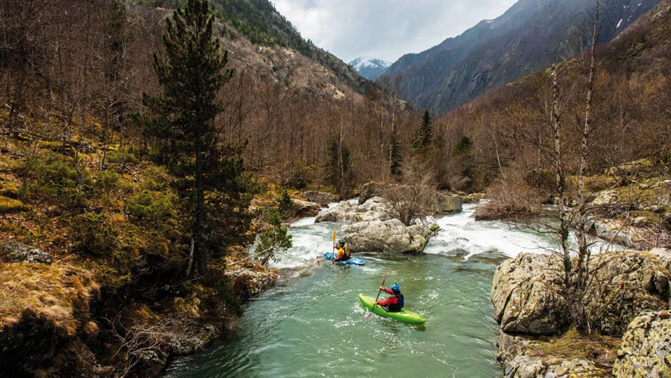
Noguera Ribagorzana / Congost de Mont-rebei (lleida/huesca): paddling the stone corridor
Mont-rebei is drama: a flooded gorge cut between vertical limestone walls where reservoir-calm water meets mountain weather. Touring here is technically easy in fair conditions, while nearby river sections can offer whitewater for experienced paddlers. Your paddle echoes off sunlit rock as swifts cut the air high above.
- At a glance:
- Level: easy (flatwater gorge) in normal conditions; advanced nearby whitewater (III+) outside the gorge
- Duration: 3–5 hours out-and-back or one-way with shuttle on the Canelles Reservoir section
- Best time: May–October; avoid windy/unstable days and storms with rockfall risk
- Why go:
- “Mont-rebei kayak” means towering cliffs, narrow passes, and unforgettable light—Spain’s signature canyon paddle
- Good option for confident beginners on a calm day; stunning photography
- Getting there:
- Main access from La Masieta (Catalonia) and Montfalcó (Aragon) trailheads/embarkation points
- Roads via
C-13and local tracks; parking is controlled—advance booking for access/parking often required in season
- Services and prices:
- Seasonal operators provide rentals, shuttles, and guided trips; some require prior reservation slots
- Typical range: 35–60 € per person for half-day; confirm availability/permits with operators or compare on Picuco
- Safety and notes:
- Regulations may limit daily craft; check management notices (Consorci del Montsec/Comarca Somontano)
- Rockfall and strong gusts are real hazards; wear PFDs, avoid hugging walls, and turn back early if wind rises
- Bring extra layers and water; shade shifts fast in the gorge
This is a bucket-list entry among the best rivers in Spain for kayaking—technically a reservoir corridor, but an unforgettable paddle that demands both respect and good timing.
Hoces del Duratón (segovia): soaring cliffs and griffon vultures
The Duratón winds through a protected canyon of horseshoe bends and high cliffs, with calm water perfect for nature-first paddling. Expect placid surface, light current, and unforgettable wildlife viewing of griffon vultures nesting on ledges. Wing shadows sweep the water like passing clouds.
- At a glance:
- Level: easy to moderate (Class I, short chutes possible depending on section)
- Duration: 3–4 hours for common circuits near San Miguel de Bernuy and Sebúlcor
- Best time: spring and autumn for mild temps; summer is fine—start early and avoid peak heat
- Why go:
- “Hoces del Duratón kayak” is a top pick for canyon scenery, abundant birds, and easy logistics
- Excellent for families and photo-minded paddlers
- Getting there:
- Access near Sepúlveda via
SG-241and local roads to San Miguel de Bernuy/Sebúlcor - Park in designated lots; follow signed put-ins to avoid erosion
- Access near Sepúlveda via
- Services and prices:
- Seasonal rentals and guided trips operate from nearby villages
- Typical range: 25–40 € per person for half-day; confirm with operators or compare on Picuco
- Safety and notes:
- Natural park rules apply; permits and seasonal restrictions protect nesting colonies
- Keep quiet near cliffs, maintain distance from ledges, and pack out all waste
- Check reservoir levels and local notices; avoid windy afternoons
Hoces del Duratón is unique for combining easy navigation with strict conservation—an example of how local communities and park rangers safeguard a world-class landscape.
The River Profile Template You Can Reuse
Make fast comparisons by copying this simple structure into your notes and filling it with the data from each section. A single whiff of river mud at the put-in tells you you’re in the right place, and this template helps confirm the rest quickly.
- Location: town/region and nearest access road (e.g., “Arriondas, Asturias; road
N-634”). - Recommended stretch and length: “Arriondas–Llovio, 12–15 km.”
- Difficulty: level and class (e.g., “easy (Class I)”).
- Typical duration: “3–4 hours at normal flows, excluding long stops.”
- Best months: “May–September; avoid windy afternoons.”
- Services: “Seasonal rentals, guides, and shuttles; book 24–48 h ahead in peak.”
- Price guidance: “25–40 € pp half-day rental incl. PFD, paddle, barrel, shuttle; confirm with the operator or compare on Picuco.”
- Ideal for: “families/beginners/intermediate/advanced.”
- Highlights: “canyon scenery, birding, swimming coves.”
- Safety: “weir at km X—portage river-left; wind risk after 13:00; cold water in spring.”
- Access and parking: “signed put-in; designated parking only; avoid blocking farm tracks.”
- Notes/permits: “park authorization required on weekends in July–August; daily quota.”
- Add-on activities: “short hike to viewpoint, winery visit, village market.”
Model sentence to open a profile: “This stretch offers easy current and generous scenery, with reliable rentals and a straightforward shuttle that make it a strong choice for first-time paddlers.”
Interactive Map To Plan Your Day
An interactive map will pinpoint launch sites, take-outs, parking, shuttle meeting points, seasonal rental bases, and nearby stays—exactly what you need to plan without surprises. One tap on a canyon marker should feel like opening a door to the day’s water and rock.
- What to include:
- Launch and take-out pins with notes on bank conditions and room for groups
- Car parks, toilets, and emergency exit trails
- Operators’ meeting points (seasonal) and suggested picnic bars/markets
- Viewpoints and sensitive wildlife zones to approach quietly
- How to build it:
- Google My Maps for a fast, shareable layer with custom icons
- Leaflet or Mapbox GL JS for embedded, mobile-friendly maps with offline tiles if needed
- Use
geojsonlayers to toggle themes (launches, hazards, services)
- Why it helps:
- Visualizing shuttles avoids backtracking and time sinks
- Families and mixed groups can see bail-out options before committing
- Icons keep the plan clear when reception drops in canyons
Before you go, download your map area for offline use and save a text version of coordinates in case batteries run low.
Choosing The Right River For Your Goal
Match your objective—relaxation, scenic travel, or technical descent—to the level you and your group actually paddle today, not last season. The right choice feels smooth and unrushed, like slipping into a shaded eddy at midday.
-
If you want relaxation and nature:
- Pick flatwater or Class I touring: Ebro Logroño–Fuenmayor, Zújar–Orellana, lower Ulla, Duratón on quiet days
- Start early, plan shore breaks, and keep return logistics simple (loop or shuttle)
- Add short walks or winery/heritage stops to lower group pressure
-
If you want progression and light adventure:
- Choose Class I–II with optional chutes: Sella (I–II), Alto Tajo (I–II most year)
- Book instruction to refine strokes, edging, and simple ferrying
- Dress for immersion, practice rescues in calm water, and pre-brief the line
-
If you want technical whitewater:
- Target spring Class II–III sections with guides (Alto Tajo; Noguera Ribagorzana river sections outside the gorge)
- Bring rescue kit (throw bag, knife, first aid), helmets, and team roles
- Scout rapids, set safety, and accept conservative lines
Beginner checklist:
- PFD that fits; closed-toe shoes; quick-dry layers; sun protection
- Sit-on-top kayaks or stable touring boats; avoid weirs; stay to shorelines
- Choose Class I, short distances, and calm forecasts; tell someone your plan
Intermediate checklist:
- Neoprene or dry top in spring; spare warm layer in dry bag
- Practice ferries, eddy turns, and reading tongues; choose Class I–II with escape routes
- Best months: shoulder seasons for flows (spring/autumn); summer for stability and warmth
Advanced checklist:
- Rescue practice; river signals; scout discipline; cold-water strategy
- Permits for parks; weather windows; flow thresholds set before departure
- Team brief with roles; throw bags ready; clear stop/go points
Blend tourism with safety by planning a single key highlight (viewpoint, birds, winery), then shaping the route and pace around it, not the other way round.
Frequently Asked Questions
A fresh breeze at the put-in is welcome, but the most important prep is clear information and a realistic plan.
Do I need a permit to kayak in these rivers?
It depends. Some protected areas (e.g., Hoces del Duratón, parts of Alto Tajo) require permits or have seasonal quotas, especially during nesting seasons. Check the natural park’s official page and the relevant river basin authority before booking.
Where can I rent kayaks and how much does it cost?
Most listed rivers have seasonal operators offering sit-on-tops, touring kayaks, and guided outings. Expect roughly 25–45 € pp for half-day touring, 35–60 € for Mont-rebei gorge circuits, and 40–65 € for guided whitewater; confirm current prices with the operator or compare options on Picuco.
What training or insurance is recommended?
For Class I–II, a short intro lesson covers strokes, edging, and self-rescue. For whitewater, take a certified course and consider adventure sports coverage that includes kayaking; verify liability and personal accident terms.
How do shuttles and parking usually work?
Touring stretches like the Sella and Ebro typically include a shuttle from take-out back to the launch. Where parking is limited (Mont-rebei, natural parks), advance booking or designated lots may be mandatory—follow signs and avoid blocking farm access.
What are the main hazards I should plan for?
Low-head dams/weirs, strainers, and wind on reservoirs are the big three. Scout and portage weirs, keep margin from downed trees, and start early to beat gusts.
Where can I check water levels and local rules?
River basin authorities—Ebro, Tajo, Guadiana, Miño-Sil—publish flow data and advisories. Park regulations come from regional environment departments; RFEP provides safety guidance aligned with the I–V scale.
Can families with children do these routes?
Yes, on Class I sections with stable weather, short distances, and properly sized PFDs. Choose sit-on-tops, keep to shorelines, build in frequent stops, and avoid weirs and windy afternoons.
Reserve your experience — discover active tourism activities in Spain with providers verified by Picuco.
Conclusion
Spain’s rivers offer a full menu: festival-friendly Sella days, vineyard drifts on the Ebro, canyon drama at Mont-rebei, bird-lit loops in Duratón, and crystal Alto Tajo pools where skills grow fast. The right choice feels aligned with your goal and level, not hurried by logistics or weather. The hush of a shaded eddy, the click of a carabiner, and one clean ferry are often the best souvenirs.
Pick one calm touring option to confirm your basics, then add a progression day or a guided whitewater taste. Use the profile template to compare routes, open the interactive map to plan shuttles and bailouts, and confirm prices and park rules before you go. If you prefer a smoother path, look for guided departures with verified local providers so you can focus on rhythm, scenery, and shared moments on the water.