Why Choose Active Tourism in Castile and León
Wild gorges, open plateaus, and high glacial cirques make active tourism in Castile and León a rare inland adventure. You’ll find river canyons, wide parameras (high, flat plateaus), and pine and oak forests that invite hiking, paddling, caving, and birdwatching at your own pace. We selected these 10 plans for their accessibility from provincial hubs, variety of activities, scenic and biodiversity value, options for different levels, and clear sustainability guidelines that respect protected areas and local communities. Think of it as a toolbox: pick a canyon for kayaking one day, a plateau for gravel cycling the next, then a summit trail to close the weekend.
A cold breeze slides through the canyons at dawn like a quiet river of air. You’ll move between Segovia, León, Soria, Burgos, Zamora, and Salamanca, with most plans reachable in 45–120 minutes from provincial capitals. These are real landscapes used by shepherds, farmers, and small-town guides, and your visit helps sustain village economies when you choose local stays and certified operators. Each plan includes what to do, how to get there, time and difficulty, typical prices, best season, and key safety and conservation tips. Prices are ranges you can confirm with the operator; many activities run seasonally, especially on water.
Here’s how to use this article to plan: scan the “best time” and “difficulty” first to match your group, then check “duration” to fit travel days. If you want a multi-day route, look for trails that link villages with accommodation options; for day trips, focus on short circular routes and boat departures with fixed schedules. If you travel with kids, prefer canyon walkways, lakeside beaches, and short interpretive paths. If you travel without a car, target destinations with train or bus connections to a nearby town and short taxi transfers. Above all, leave no trace, book ahead in peak months, and enjoy the inland nature that Castile and León protects and shares.
Picuco te puede ayudar
Does something here catch your eye?
Tell us.
Write to us on WhatsApp or email: we answer questions, find the best options and help you sort out the booking.
Where These 10 Plans Are
You’ll be moving across six provinces: Segovia (Hoces del Duratón), León (Hoces de Vegacervera and Valporquero cave; Riaño), Soria and Burgos (Río Lobos canyon; La Yecla), Zamora (Lago de Sanabria; Arribes del Duero north), and Salamanca (Arribes south; Las Batuecas; Pozo de los Humos). The interactive or static map should mark each plan with icons by activity—boot for hiking, paddle for kayak, cave for caving—so you can spot clusters for efficient itineraries. Distances are large; plan 60–150 km hops and keep fuel, water, and snacks handy in rural stretches.
Rivers thread the map like ink lines between ochre cliffs and dark-green pines. By car, provincial capitals are the best gateways: Segovia for Duratón, León for Vegacervera/Valporquero and Riaño, Soria for Río Lobos and Urbión, Burgos for La Yecla, Zamora for Sanabria and Arribes (north), and Salamanca for Arribes (south), Las Batuecas, and Pozo de los Humos. Trains (Madrid–Segovia, Madrid–León, Madrid–Zamora, Madrid–Burgos) and regional buses connect to many towns; from there, a short taxi can reach trailheads or boat piers. Useful map layers include protected areas (Natural Parks, Natura 2000), visitor centers and tourism offices, official viewpoints, and water access points. Save pins for parking areas and check seasonal road or shuttle restrictions at high-use sites like Laguna Negra.
10 Active Plans Across Gorges, Plateaus, and Inland Nature
A tawny vulture circling above limestone cliffs is often your silent trail companion.
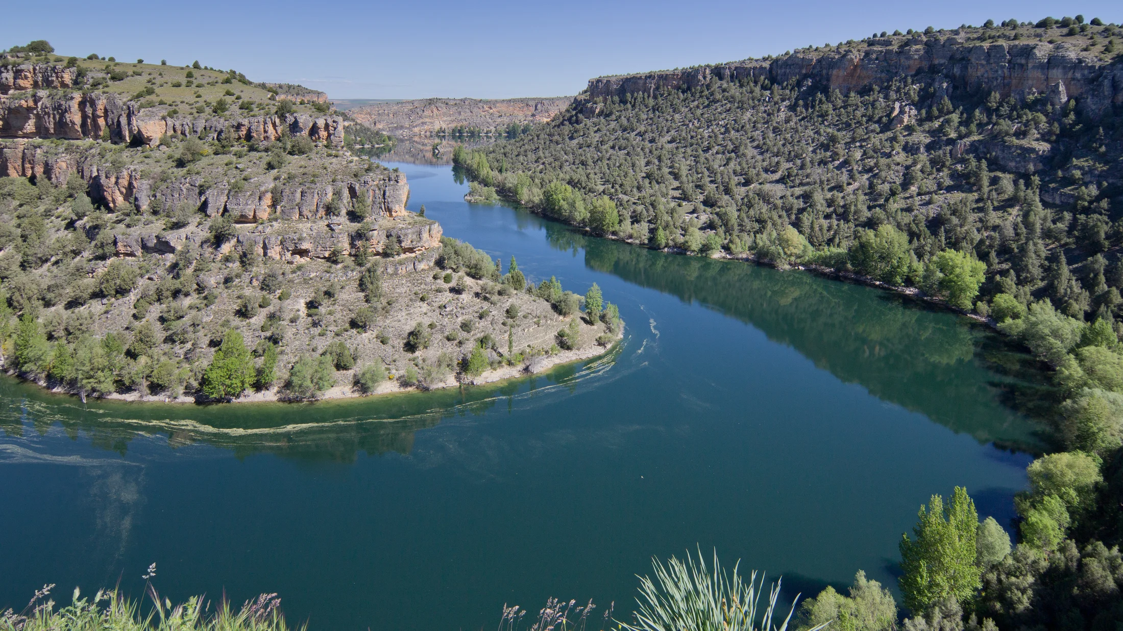
1.Hoces del Río Duratón (segovia): hiking and kayaking
Canyons, hermitages, and calm waters define the Parque Natural Hoces del Duratón near Sepúlveda. The Duratón gorges host one of Spain’s strongest griffon vulture populations, and the classic viewpoint at the Hermitage of San Frutos frames a sweeping bend. Trails range from easy riverside strolls to longer rim paths, while calm-flow kayaking reveals overhangs, caves, and sandy banks.
Sunlight glints off still water beneath honey-colored walls.
- Why go: Iconic “hoces Castile and León” scenery, easy hiking routes in Castile and León, and serene paddling that suits beginners.
- Activities: Short hikes to San Frutos and Mirador de los Dos Aguas; kayak or canoe trips from San Miguel de Bernuy or Sebúlcor; birdwatching.
- Getting there: 63 km from Segovia (≈55 min via SG-232); 150 km from Madrid (≈1 h 45 via A-1 to Sepúlveda).
- Duration/difficulty: 2–6 h on foot; kayaking 2–3 h; easy to moderate.
- Prices: Kayak Castilla y León rentals/guided 20–40 € p.p. (2–3 h); confirm with the operator or compare options on Picuco.
- Best time: Spring and autumn; early summer mornings for paddling; check breeding-season restrictions.
- Safety/conservation: Park rules limit access near nesting cliffs; no loudspeakers or drones; carry water, hat, and sunblock; pack out all trash.
2.Hoces de Vegacervera and Valporquero Cave (león): caving and viewpoints
Limestone gorges cut by the Torío River lead to the Cueva de Valporquero, one of Spain’s emblematic show caves. The road through the Hoces de Vegacervera threads between vertical walls with roadside pullouts and short paths to viewpoints. Inside Valporquero cave, guided tours cover lit chambers with stalactites and underground lakes; advanced speleology routes with water require qualified guides and bookings.
Cave air smells cool and mineral as water whispers from hidden pools.
- Why go: Gorge viewpoints plus the Cueva de Valporquero make a classic canyon-and-cave day.
- Activities: Scenic drive and short walks in Vegacervera; cave visit (basic and extended circuits); guided adventure caving.
- Getting there: 48 km from León (≈50 min via LE-311).
- Duration/difficulty: Cave tours 1–2 h; hikes 30–90 min; sightseeing easy; adventure route moderate–demanding with wetsuit and gear.
- Prices: Show-cave entry typically 6–15 € p.p. depending on circuit; adventure routes 40–70 € p.p.; reserve in advance.
- Best time: Spring to autumn; check winter schedules for cave and road conditions.
- Safety/conservation: Follow cave staff instructions; no touching formations; in gorges, beware rockfall zones and narrow shoulders—park only in marked bays.
3.Cañón del Río Lobos (soria/burgos): trails and birdwatching
The Río Lobos canyon is a long limestone corridor with riparian woods, caves, and the small Templar hermitage of San Bartolomé near Ucero. It’s a reference for hiking routes in Castile and León and a favorite for birders seeking vultures and cliff-nesting species. Most visitors walk a flat riverside section before branching to viewpoints above the cliffs.
The scent of juniper drifts in warm air as wings slice the silence.
- Why go: Classic canyon walking and reliable raptor sightings with cultural stops.
- Activities: Riverside trail from Ucero to San Bartolomé; climbs to Mirador de las Gullurías; photography at dawn and late light.
- Getting there: From Soria city 68 km (≈1 h via N-122 to Ucero); from Burgos 155 km (≈2 h).
- Duration/difficulty: 2–5 h hiking; mostly easy, short steep spurs to rim views.
- Prices: Access is free; guided nature walks 15–30 € p.p.
- Best time: Spring for flowers and active birds; autumn for colors; avoid midday heat in summer.
- Safety/conservation: Stay on paths; respect nesting signs; bring binoculars, 1–2 L water, hat, and grippy shoes for dusty climbs.
4.Laguna Negra and Picos de Urbión (soria): high-mountain trails
Laguna Negra, a cirque lake set in dark cliffs at about 1,750 m, anchors classic ascents to the Picos de Urbión (2,228 m). Trails cross pine woods and open parameras above the treeline before cresting views over Soria and La Rioja. In peak season, shuttles manage access to upper parking; in winter, expect snow and ice.
A thin wind ripples the black surface like brushed silk.
- Why go: A glacial lake-to-summit day with big-landscape rewards.
- Activities: Hike from Laguna Negra to Pico Urbión; detour to the source area of the Duero; snowshoeing in winter with proper gear.
- Getting there: 50 km from Soria (≈55 min via SO-820 to Vinuesa and forest road to parking).
- Duration/difficulty: 5–7 h round trip to Urbión; moderate–demanding with 700–900 m ascent.
- Prices: Parking/shuttle small fee in peak season; guided ascents 30–50 € p.p.
- Best time: Late June–October; shoulder seasons for fewer people; winter only with alpine skills/equipment.
- Safety/conservation: Weather changes fast; carry layers, map/GPS, and headlamp; hail and fog are common—turn back early if conditions deteriorate.
5.Lago de Sanabria Natural Park (zamora): kayaking and lake swims
Spain’s largest glacial lake (≈3.5 km²; max depth ≈51 m) sits amid beech, oak, and chestnut woods near Puebla de Sanabria. Beaches like Viquiella and Custa Llago offer gentle entries for families, and calm mornings are ideal for kayaks and SUP boards. Short trails loop through lakeshore woods and climb to waterfalls on nearby streams.
Water laps over granite pebbles in a soft, metronomic hush.
- Why go: Warm-season swimming, kayak Castilla y León options, and shaded walks in one compact park.
- Activities: Kayak/SUP rentals at beaches; perimeter paths and interpretive routes; boat tours (in season).
- Getting there: 15 km from Puebla de Sanabria (≈20 min); from Zamora city 100 km (≈1 h 20 via A-66/A-52).
- Duration/difficulty: 2–5 h combining paddle and short hikes; easy.
- Prices: Kayak/SUP 10–20 € per hour; guided tours 20–35 € p.p.; summer parking fees at busiest areas.
- Best time: June–September for swims; May–October for hiking; mornings for glassy water.
- Safety/conservation: Respect bathing zones; life jacket on watercraft; no fires; follow park rules on pets and waste; sudden afternoon winds can challenge paddlers.
6.Arribes del Duero (zamora/salamanca): canyons and river cruises
Along the Spanish–Portuguese border, the Duero slices granite to form the deep Arribes canyons. A network of miradores peers into the gorge, and boats navigate tranquil stretches below dams, revealing vertical stone faces and nesting birds. Trails connect villages, vineyards, and olive groves while the long-distance GR-14 (Senda del Duero) threads the region.
The river moves like a slow, polished ribbon between shadowed walls.
- Why go: Big-canopy viewpoints plus low-effort cruises that suit mixed groups.
- Activities: Boat tours from riverside piers; hikes between miradores (e.g., Picón de Felipe, Mirador del Fraile); flora and fauna watching.
- Getting there: From Zamora to Fermoselle ≈56 km (≈55 min); from Salamanca to Aldeadávila ≈120 km (≈1 h 40).
- Duration/difficulty: Boat tours 1–2 h; hikes 1–4 h; easy to moderate with some rocky sections.
- Prices: Cruises typically 16–25 € p.p.; guided hikes 15–30 € p.p.
- Best time: Spring for blooms and mild temps; autumn for harvest colors; summer sunsets for photography.
- Safety/conservation: Cliffs are exposed—keep well back from edges; high heat in summer—carry extra water; respect vineyard and pasture gates.
7.Las Batuecas – Sierra de Francia (salamanca): quiet trails and rural silence
This Natural Park blends deep valleys, chestnut terraces, and slate villages like La Alberca and Mogarraz. The Batuecas valley shelters hermit caves and a monastery, and paths follow the river under dappled light. It’s a place to walk slowly, pair short hikes with village visits, and enjoy local cheeses, honey, and cured meats.
Pine resin and wet rock scent the shade as water murmurs over slabs.
- Why go: Gentle hiking with cultural depth and true quiet.
- Activities: River path in Las Batuecas; village-to-village routes; artisanal food stops and craft workshops.
- Getting there: From Salamanca city 75–85 km (≈1 h 30 via SA-210 to La Alberca).
- Duration/difficulty: 1–4 h walks; easy to moderate; good for families seeking shade and short climbs.
- Prices: Mostly free; occasional small museum/interpretive fees; guided walks 12–25 € p.p.
- Best time: Spring and autumn; winter for solitude; avoid midday summer heat in valleys.
- Safety/conservation: Narrow roads—drive slowly; respect monastery silence; carry cash for small village purchases; stay on marked paths to protect terraces.
8.Pozo de los Humos and nearby waterfalls (salamanca): trails and photography
Pozo de los Humos on the Uces River plunges around 50 m near Masueco and Pereña de la Ribera. Access trails exist from both villages to opposing viewpoints, so you can frame the falls from different angles. Flow peaks after heavy rain and in late winter–spring snowmelt; in dry summers the waterfall may dwindle, but canyons remain photogenic.
Mist eddies over the brink like breath on cold glass.
- Why go: Powerful seasonal waterfall and easy approach routes with big views.
- Activities: Short hikes to balconies; photography at morning/afternoon angles; link to other cascades in Arribes tributaries.
- Getting there: From Salamanca city 95–105 km (≈1 h 30); trailheads from Masueco and Pereña with signed parking.
- Duration/difficulty: 1–2.5 h total depending on side; easy to moderate with short rocky sections.
- Prices: Free access; optional guided routes 12–25 € p.p.
- Best time: After rains (Nov–May); weekdays and early mornings to avoid crowds.
- Safety/conservation: Edges are slippery; keep distance from rails; use trekking poles in wet; respect private farmland near paths.
9.Riaño Reservoir and Leonese plateaus: water sports and cycling
The turquoise Embalse de Riaño spreads among sharp limestone peaks in northern León, perfect for calm-water paddling on quiet days. Nearby, the broad Leonese parameras—high, open plateaus south of León—offer gravel cycling on farm lanes with big-sky horizons. Combine a mountain-morning paddle with an afternoon spin, or split water and wheels on two days.
A dragonfly skims the reservoir as cowbells echo across the valley.
- Why go: Two contrasting landscapes in one province—fjord-like paddling and expansive plateau rides.
- Activities: Kayak/SUP hire at Riaño; short hikes to hanging bridges and viewpoints; gravel loops on El Páramo farm tracks.
- Getting there: Riaño is 90 km from León (≈1 h 15 via N-621); El Páramo trailheads 20–40 km south of León.
- Duration/difficulty: Paddle 1.5–3 h; cycling 2–5 h; easy to moderate depending on wind and route.
- Prices: Kayak/SUP 15–25 € per 2 h; bike rentals 20–35 € per day; guided combos 35–60 € p.p.
- Best time: Late spring–early autumn; mornings for calmer water; shoulder seasons for cooler cycling.
- Safety/conservation: Wind can rise fast—hug shorelines; life jackets mandatory; carry tools, spares, and sun protection on exposed plateaus.
10.Desfiladero de La Yecla and small gorges (burgos): day escapes
Near Santo Domingo de Silos, the Desfiladero de La Yecla is a short walkway squeezed between walls carved by the Arlanza tributaries. Suspended footbridges and tunnels make an easy, dramatic outing that pairs well with a visit to the monastery or to the oak savanna of the Sabinares del Arlanza Natural Park. Nearby short gorges like the Mataviejas at Ura add variety.
Cool spray beads on the metal rail as water stitches past your feet.
- Why go: Maximum canyon drama for minimum effort, great with kids or tight schedules.
- Activities: Walkway loop at La Yecla; short trails to miradores; quick photo stops in nearby defiles.
- Getting there: 65 km from Burgos (≈55 min via N-234 and BU-910); parking at both ends of the walkway.
- Duration/difficulty: 30–60 min; easy; combine with 1–2 h in Silos and Sabinares viewpoints.
- Prices: Free access; optional local guides 10–20 € p.p.
- Best time: Year-round; mornings and late afternoons for fewer people and softer light.
- Safety/conservation: Narrow footbridges—single file; avoid in flash-flood forecasts; respect closures for maintenance.
How to Read These Plans Quickly
Each plan ends with a compact field list so you can filter fast. “Prices” show typical ranges for rentals, guided tours, or entries; exact rates vary by season and group size—confirm with the operator. “Best time” balances climate, water levels, bird nesting, and crowd patterns. “Duration/difficulty” uses plain language: easy (family-friendly, short climbs), moderate (longer or steeper sections), demanding (significant ascent, exposure, or technical needs). “Activities” list the best fits—hiking, kayak, caving, cycling, birding—and you can stack two light activities in one day if drives are short.
Warm pine smells like sunbaked resin along many of these paths.
Use the examples: if “Prices: Kayak 15–25 € per 2 h; guided 35–60 € p.p.”, budget 20–30% extra for peak weekends. If “Best time: after rains (Nov–May)”, avoid dry spells for waterfalls. If a plan says “Shuttle/parking fee in season”, carry coins or a card and arrive early. For mixed groups, pair an “easy” canyon walkway with an “easy–moderate” village loop, and keep a picnic ready to reduce midday driving. When a route references a long-distance path like GR-14 or GR-86, you can extend or shorten stages by starting at different villages; tourism offices can suggest family variants or expert detours. Finally, read “Safety/conservation” as non‑negotiable: these notes protect you, wildlife, and the people who live here.
Practical Tips for Active Days in Castile and León
Pack intentionally and you’ll move lighter and safer between gorges and plateaus.
- Footwear and clothing:
- Hiking: grippy trail shoes/boots, breathable layers, hat, sunglasses.
- Water: neoprene booties or secure sandals, swimsuit, quick‑dry top, windbreaker.
- Caving: thermal base, full change of clothes; guides provide wetsuit/helmet.
- Safety gear:
- Headlamp, small first-aid kit, whistle, power bank, paper map or offline GPS.
- Life jacket always on boats/SUP; helmet where required; trekking poles for slippery paths.
- Permits and park rules:
- Some parks regulate kayak departures (e.g., Duratón in nesting season); book with authorized operators.
- Drones are typically restricted; camping and fires are prohibited outside designated areas.
- Booking reliable activities:
- Choose certified operators with clear safety briefings, insurance, and small group ratios.
- Reserve weekends and holidays 1–3 weeks ahead; shoulder seasons offer more flexibility.
- Rural stays and mobility:
- Base yourself in a hub town (Sepúlveda, Puebla de Sanabria, Riaño, La Alberca) to reduce daily driving.
- Fuel up before remote stretches; many villages have limited hours or cash‑only shops.
- Sustainability:
- Stay on marked trails, close gates, and yield to livestock and farm vehicles.
- Carry all waste out, refill bottles at village fountains where potable, and buy local to support communities.
If you plan mixed activities the same day, do water first in calm morning conditions, then hike shaded routes through the afternoon.
Frequently Asked Questions
The hush of a canyon at sunrise is reason enough to start early and unhurried.
Do I need a guide for kayaking or caving?
For flatwater kayaking on lakes and calm river sections, experienced paddlers often go self-guided with proper safety gear. For caving beyond show-cave circuits, you must go with qualified guides who provide helmets, lights, and (if aquatic) wetsuits.
Can I rent kayaks near lakes and reservoirs?
Yes, in summer and many weekends from late spring to early autumn. Look for rentals at main beaches or piers around Lago de Sanabria and Riaño; typical rates are 10–25 € depending on duration and craft.
Are the gorges suitable for families with children?
Many are. La Yecla’s walkway, short sections of Duratón and Río Lobos, and shaded paths in Las Batuecas work well. Keep distances short, bring snacks and water, and avoid exposed cliff edges.
What is the best season to avoid snow or heavy rain?
Late spring to early autumn is most reliable. High mountains (Urbión) can hold snow into May; waterfalls peak after rains (winter–spring), while summer storms can be intense but brief—check daily forecasts.
Can I travel with pets?
Policies vary by park and operator. Many trails allow leashed dogs; boat tours and shuttles often don’t. Always verify pet rules in advance with the local tourism office or operator.
How do I check access restrictions and permits?
Consult provincial park pages of the Junta de Castilla y León and local visitor centers for seasonal closures, watercraft limits, and fire-risk alerts; phone numbers are posted at trailheads and town halls.
Book your experience — discover active tourism in Spain with providers verified by Picuco.
Conclusion
Active tourism in Castile and León rewards those who like movement with meaning: gorges to hike and paddle, glacial lakes to swim, caves to explore, and plateaus to ride beneath wide skies. The same trails and rivers shape village life, so traveling gently—staying local, booking certified guides, respecting nesting seasons, and leaving no trace—keeps these places thriving. Aim for early starts, shoulder seasons, and small-group outings; carry water, layers, and good maps; and choose routes that fit your time and experience.
To go deeper, contact provincial tourism offices in Segovia, León, Soria, Burgos, Zamora, and Salamanca for updated access notes and shuttle timetables. Park visitor centers provide trail maps and safety briefings, and local guides add natural history that turns a walk into understanding. When you’re ready, plan two or three neighboring plans in one trip—Duratón with Río Lobos, Sanabria with Arribes, Riaño with Urbión—to feel the inland geography unfold under your feet and paddle. Then bring the quiet home, and return in a new season to see how the landscape changes and how your own pace adapts with it.