Why Las Médulas Belongs on Your Hiking List
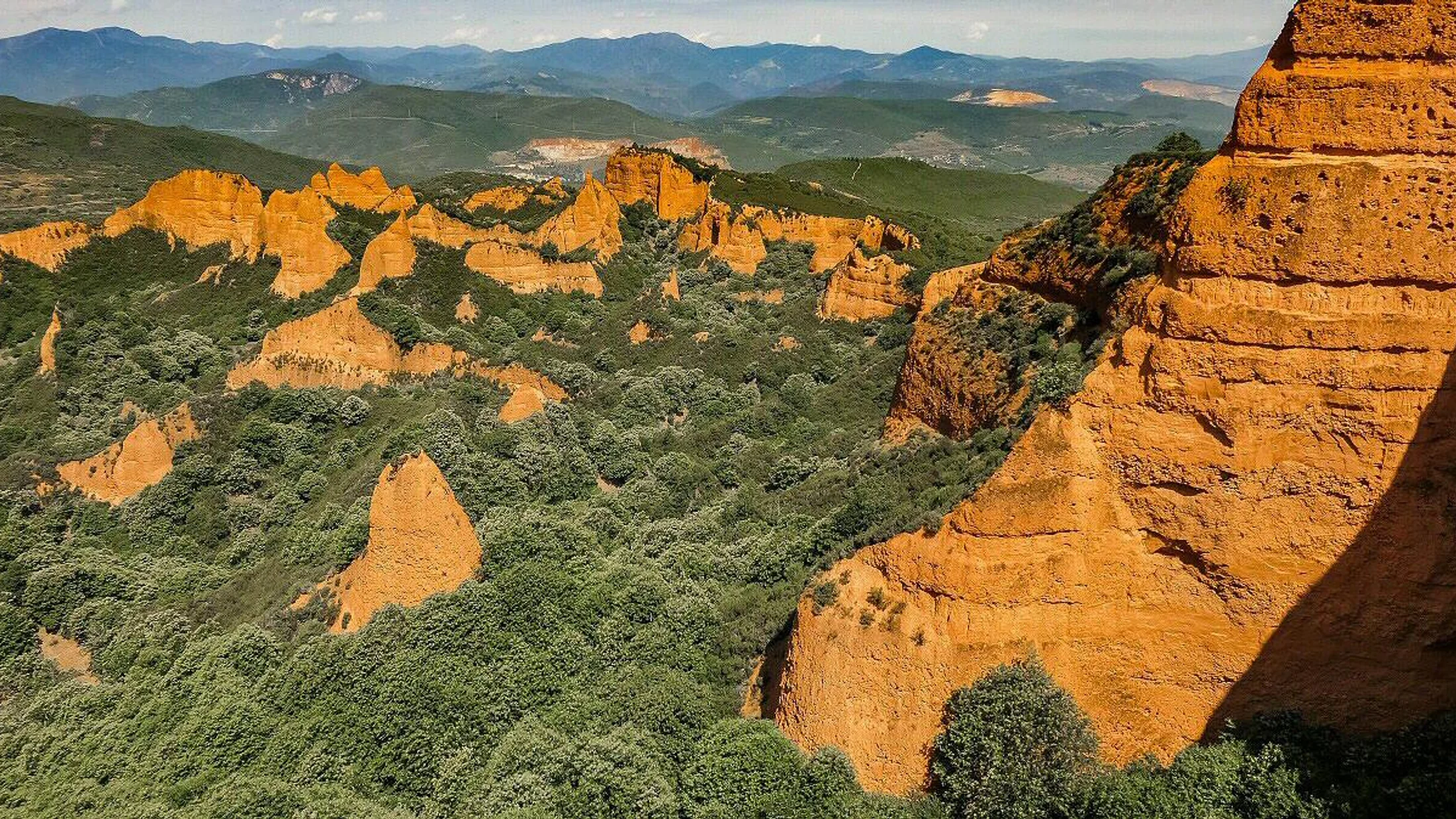
Stand beneath rust-red cliffs and you feel time pressed into the earth. Las Médulas, a UNESCO World Heritage cultural landscape since 1997, is where Roman engineering reshaped a Bierzo hillside into a labyrinth of pinnacles, hollows, and chestnut groves. You’ll hike through history here, and each turn offers a new angle on geology, archaeology, and living rural culture.
One breath of cool shade under the chestnuts smells faintly of wet earth and sweet leaves. In this article, you’ll find six carefully chosen routes in Las Médulas and El Bierzo that balance archaeology, views, and varied terrain. Expect clear distances, ascent figures, travel logistics, and who each route suits best—from families to photographers—so you can plan with confidence.
Heritage landscape shaped by water and time
The Romans used ruina montium—literally “collapse of mountains”—a method that flushed water through tunnels to fracture bedrock and wash out gold-bearing sediments. In plain terms: they carved channels, filled reservoirs, and let gravity do the mining. The result, Las Médulas, is both an archaeological site and a living landscape managed with community care and conservation rules.
As a UNESCO World Heritage Site (inscribed 1997), Las Médulas must balance public access with preservation of fragile formations and ancient hydraulic works. That means signed trails, controlled access to certain galleries, and visitor centers to explain context. In practice, you can walk amid blazing orange spires while respecting a place that is both monument and village commons.
Sunlight glows on the clay like embers at sunset. When we say “Las Médulas,” we mean the core area near the hamlets of Las Médulas and Orellán, within the wider region of El Bierzo (León province), where mining heritage extends into vineyards, chestnut woods, and valley viewpoints.
How we chose these six routes
We selected six hikes to fit real weekends and mixed groups. You’ll see a spread of trail lengths, levels, and vantage points.
- Distance and duration: from 20–40 minute viewpoint walks to 3–6 hour circuits.
- Difficulty: easy family-friendly strolls to moderate-perimeter loops; no technical scrambling.
- Panoramas and archaeology: miradores, Roman galleries, channels, and carved amphitheaters.
- Accessibility: waymarked paths, close trailheads, and options near services in El Bierzo.
- Safety: obvious signage, solid surfaces, and routes that avoid unstable slopes.
Crisp morning air hums with bees in spring. Families, casual hikers, photographers, pilgrims on the Camino de Invierno, and experienced walkers seeking quieter corners will all find a route here that makes sense for the time and energy they have.
Picuco te puede ayudar
Does something here catch your eye?
Tell us.
Write to us on WhatsApp or email: we answer questions, find the best options and help you sort out the booking.
Getting There and Practical Logistics
You don’t need to overcomplicate travel in El Bierzo. With Ponferrada as the hub and the A-6 corridor nearby, reaching Las Médulas is straightforward by car and manageable with public transport plus a short taxi.
Access and public transport
From Ponferrada, drive west on the N-536 toward Carucedo and O Barco de Valdeorras; at Carucedo, follow signs up to Las Médulas village. It’s roughly 25–30 km, about 35–40 minutes depending on traffic and season. From the A-6, use exits for Ponferrada, then continue via N-536 as signed.
Warm air carries a hint of woodsmoke from village chimneys in autumn. By train, Ponferrada station connects with León and Madrid; by bus, regional services link Ponferrada with León and other Castilla y León cities. Local buses toward Carucedo/Las Médulas run seasonally and infrequently—confirm timetables in advance and consider a taxi for the last 12–15 km if needed. Within El Bierzo, driving allows you to pair Las Médulas with stops in Villafranca del Bierzo or Molinaseca.
Good to know
In high season and on holiday weekends, add 15–20 minutes to drive times for village traffic and parking.
Parking, trailheads and services
Main trailheads cluster around Las Médulas village, the Visitor/Interpretation Centre near Carucedo, and the Orellán viewpoint area. You’ll find signed parking in Las Médulas (for village access and the Senda Perimetral) and near Orellán (for the mirador and gallery). Some car parks are small; arrive early on weekends.
The clay dust feels fine as powder beneath your boots on dry days. Parking is typically free, though some private lots may request a fee; the Orellán gallery (a short tunnel with a balcony view) usually has a small admission—check on-site notices. Services include:
- Visitor/Interpretation Centre: exhibits, maps, staff advice, and WC in opening hours.
- Bars and small eateries in Las Médulas village; more options in Carucedo, Borrenes, and Ponferrada.
- Lodging: consider bases in Villafranca del Bierzo or Molinaseca for broader services and evening strolls.
Best time to go and what to pack
Spring and autumn offer mild temperatures, long daylight, and peak colors—green chestnuts in May–June, copper-gold leaves in October–November. Summer can be hot and exposed mid-day; winter is quieter but can bring rain and short days.
A breeze stirs dry leaves like paper in late October. Pack sturdy footwear with grippy soles, 1–2 liters of water per person (few reliable fountains on route), sun protection, a light layer for shade and tunnels, and a small headlamp if visiting any galleries.
Top 6 Hikes in Las Médulas and El Bierzo
Below, each route includes: where it starts, distance/time/ascent, difficulty, costs if any, best season, who it suits, highlights, and a logistics tip. Use this as a quick scan to match your day.
1) Senda Perimetral — the signature loop around Las Médulas
Walk the classic loop that skims the foot of the cliffs and threads chestnut groves. Starting from Las Médulas village, the Senda Perimetral forms a circuit of roughly 10–12 km, 250–350 m total ascent, and 3–4 hours at an easy-moderate pace on signed paths.
Sunlight licks the orange walls and turns them to glowing sugar at golden hour. Expect waymarking at junctions and information panels; surfaces are generally stable, with some short, steeper ramps. There’s no trail fee; parking is generally free, though private lots may vary. Best months: April–June and late September–November for color, softer light, and fewer crowds.
- Ideal for: first-time visitors, photographers, small groups.
- Highlights: views of the amphitheater-like spires, chestnut copses, Roman water channels and spoil heaps.
- Logistics: carry water—no reliable fountains on-route; shade is patchy; a light scarf helps with clay dust on windy days.
For senderismo Las Médulas you can’t beat this overview: it’s the circuit that shows you both the human story and the living forest.
2) Mirador de Orellán — the classic panorama in minutes
If you want “the” postcard in the least time, head to the mirador Orellán above the village. Drive to Orellán and follow signs to the viewpoint parking; the walk from car park to platform is about 10–15 minutes on a short, steep path. Approximate coordinates: 42.46°N, 6.77°W.
The wind at the balcony edge smells of pine resin and sun-warmed rock. The panorama sweeps across the entire Las Médulas amphitheater, with the Orellán gallery below (often open with a small entry fee; bring small change and a light). Best light: early morning for side-lit textures or late afternoon for warm tones; sunset can be dramatic but busier.
- Ideal for: families, travelers with limited time, tripod-carrying photographers.
- Duration: 20–40 minutes round trip to the platform; add 20–30 minutes for the gallery visit.
- Costs: viewpoint free; gallery admission typically small—check on-site.
- Logistics: limited parking on peak days; fold this stop into the
Senda Perimetralor visit before/after the main loop.
This is senderismo Las Médulas at its most accessible: a few minutes’ effort for a sweeping lesson in Roman landscape engineering.
3) Medulillas and secondary paths — a quieter corner
Step off the main loop to the Medulillas, smaller formations and interlaced paths that see fewer boots. Start from Las Médulas village or link from the Senda Perimetral; plan 6–8 km and 2–3 hours with gentle ups and downs and occasional narrow sections.
A blackbird’s call echoes in the hush of a shaded hollow. Waymarking is present but thinner than on the main loop, so carry a simple offline map; surfaces can be sandy or dusty after dry spells. There’s no fee, and it’s best from spring to late autumn when the undergrowth is green and the chestnuts are leafed out.
- Ideal for: walkers seeking calm, flora enthusiasts, photographers after oblique angles.
- Highlights: secondary viewpoints, botanical variety in the chestnut understory, smaller-scale Roman cuts and channels.
- Variants: short spurs to minor miradores; link back to the village for coffee.
Tucked within El Bierzo’s broader mosaic, this part of Las Médulas rewards unhurried steps and careful looking.
4) Archaeological Park circuit — mining story at walking pace
Make time for the Archaeological Park facilities and a short interpretive walk that ties the landscape to the Roman mining system. Begin at the Visitor/Interpretation Centre near Carucedo or in Las Médulas village, where signed paths of 2–4 km let you visit viewpoints, panels, and, when open, the Orellán gallery.
A cool draft brushes your hands inside the dim of a tunnel. Difficulty is easy, surfaces mostly compacted, and durations run 45–90 minutes depending on stops. Entry to trails is free; guided visits and the gallery usually have modest fees—confirm current schedules and prices at the center before setting off.
- Ideal for: families, history lovers, anyone who wants context first.
- Highlights: mining panels, cross-sections of channels, scenic overlooks that match diagrams to real terrain.
- Best time: spring and autumn for mild weather; winter for a quieter, contemplative visit.
By walking the explanatory loops before or after other hikes, the minas romanas of Las Médulas and their waterworks come into sharp focus across El Bierzo.
5) A stretch of the Camino de Invierno — history underfoot
Follow a signed segment of the Camino de Invierno, the “winter” alternative of the Camino de Santiago that skirts the high snows. One rewarding day route runs Borrenes → Las Médulas → Puente de Domingo Flórez, about 18–22 km, 450–600 m ascent, 5–6 hours on mixed village lanes, tracks, and paths.
Boots thud softly on old stone as church bells count the hours at noon. Waymarking uses the familiar yellow arrows and scallop shells; navigation is straightforward. The route is free, with services in villages en route depending on opening times. Best seasons are spring and autumn; in summer, start early to beat heat, and in winter watch for short daylight and wet ground.
- Ideal for: pilgrims, long-distance hikers, walkers who want a linear day with public-transport or taxi return.
- Highlights: vineyard vistas, mining vistas around Las Médulas, village heritage in Carucedo and Borrenes.
- Logistics: base in Ponferrada, Molinaseca, or Villafranca del Bierzo; arrange pickup or return by taxi from Puente de Domingo Flórez.
This El Bierzo hiking day blends cultural waymarks with the earthwork drama of the mines.
6) Circular from Molinaseca or Villafranca — village life and viewpoints
If you’re lodging beyond the core site, pair a village circuit with regional panoramas before or after Las Médulas. A Villafranca del Bierzo loop via hillside tracks and vineyard lanes runs 10–14 km, 300–450 m ascent, 3–4 hours. A Molinaseca balcony loop in the foothills above the LE-142 is similar in distance and effort.
The scent of crushed grape skins lingers near stone cellars in harvest season. These walks are easy-moderate, signed at key junctions but best done with a simple GPX. Trailheads start from central parking in each town; both have cafés, bakeries, and small shops for supplies.
- Ideal for: travelers who want culture + trail without extra driving that day.
- Highlights: Romanesque bridges, old quarters, vineyard viewpoints, distant ridgelines that frame El Bierzo.
- Best time: year-round; spring bloom and autumn vendimia add color and local rhythm.
Combine this with a half-day at Las Médulas for a full sense of the region’s mining past and present-day rural life.
Map of Trailheads and Viewpoints
Use an interactive map to keep the day simple and safe. Whether you prefer Google Maps or an open-source Leaflet embed, plot the essentials as separate layers: trailheads (Las Médulas village, Orellán parking, Visitor Centre), key viewpoints (Mirador de Orellán, secondary miradores), parking areas, the Senda Perimetral trace, and the Camino de Invierno segment across El Bierzo.
The map flickers alive with orange polygons and green woods like a living blueprint. For each point, add GPS coordinates, estimated times, ascent, difficulty, and season notes. Include symbols for services—WC, water (if available), cafés—and simple cautions such as “exposed” or “slippery when wet.” If you plan a weekend, create two layers: Day 1 (perimeter loop + Orellán) and Day 2 (Medulillas + village circuit), so you can toggle between options at a glance.
Save the map offline, especially if you expect patchy signal. With clear icons and a printed backup, you’ll spend the day walking rather than checking your phone.
How to Choose the Right Route for You
Match the hike to your time, energy, and interests, and the day will sing. Start with duration: if you have only an hour, go straight to Mirador de Orellán; for a half-day, choose the Senda Perimetral; for a quieter half-day, try the Medulillas detours; for a full linear day, take a Camino de Invierno stretch.
Chestnut burrs crunch like brittle shells underfoot in late autumn. Consider these factors:
- Fitness and footing: paths can be sandy or clay-slick after rain; trekking poles help on short steeps.
- Heat and exposure: midday sun bounces off orange walls; early and late light are cooler and more photogenic.
- Family needs: choose short interpretive loops with WCs nearby; Orellán offers quick rewards.
- Pets: dogs should be leashed near drop-offs and livestock; carry extra water.
- Archaeology vs. scenery: the park circuit maximizes context; the
Senda Perimetraland Orellán maximize panoramas.
If you like to compare at a glance, use this quick matrix:
| Route type | Time | Distance | Effort | Best for | Notes |
|---|---|---|---|---|---|
| Scenic viewpoint (Orellán) | 20–40 min | <1 km | Easy | Families, photographers | Pair with gallery when open |
Signature loop (Senda Perimetral) |
3–4 h | 10–12 km | Easy–moderate | First-timers, groups | Mixed shade, bring water |
| Quiet detours (Medulillas) | 2–3 h | 6–8 km | Easy–moderate | Solitude, flora | Thinner signage, carry map |
| Long-distance (Camino Invierno section) | 5–6 h | 18–22 km | Moderate | Pilgrims, fit hikers | Arrange return transport |
| Village circuit (Molinaseca/Villafranca) | 3–4 h | 10–14 km | Easy–moderate | Culture + trail | Year-round option |
To combine routes in one day:
- Dawn at Orellán for photos.
- Mid-morning
Senda Perimetralcounterclockwise to ride the shade. - Late lunch in Las Médulas village.
- Short Medulillas spur if energy allows.
In summer, shift to early starts and siesta hours. For a weekend, do the signature loop on Day 1, then a Camino Invierno stretch or a village circuit on Day 2 to broaden your El Bierzo picture.
Rules, Conservation and Safety in the Natural Monument
The landscape you walk is both monument and home. Stay on signed paths to protect unstable clay faces and archaeological remains; do not climb formations, open new shortcuts, or enter closed tunnels. Collecting minerals, digging, or removing artifacts is prohibited by heritage law and subject to fines.
A quiet drip echoes in closed galleries like a metronome of time. Fire risk rises in summer and early autumn: no open flames, and respect any temporary closures. Pack out all litter, including organic waste that attracts wildlife. With centuries-old chestnut orchards around villages, give right of way to farm access and close gates behind you.
For safety:
- Check forecasts and avoid the highest clay paths after heavy rain; clay becomes slick and unstable.
- Tell someone your route and timing; mobile coverage can be limited in hollows.
- Carry water, sun protection, and a light for tunnels you intend to visit.
- Follow on-site signage; galleries may close temporarily for maintenance.
In case of emergency in Spain, dial 112 and provide your GPS coordinates. Local municipalities (Borrenes, Carucedo) may publish seasonal notices about access or parking—scan boards at the Visitor Centre or village entrances. Respecting the rules keeps you safe and ensures the Roman gold mines story stays legible for the next visitor.
Frequently Asked Questions
Do I need a permit to visit Las Médulas?
No permit is required to walk the signed trails or visit the viewpoints. Certain galleries or guided tours may have capacity limits and scheduled entry—check at the Visitor/Interpretation Centre upon arrival.
Are there any costs or tickets?
Access to the landscape and most trails is free. The Orellán gallery and some guided activities typically have a small fee; confirm current prices and times at the centre on the day of your visit.
Can I bring my dog?
Yes, dogs are allowed on public trails but must be on a leash near drop-offs, livestock, and in village areas. Carry water for pets; bowls at bars are not guaranteed.
Are there guided tours and how do I book?
Yes, guided walks and interpretive visits run regularly in season, with extra sessions on weekends and holidays. Book on arrival at the Visitor/Interpretation Centre, via local tourism offices in Ponferrada or Villafranca del Bierzo, or plan ahead with curated options on Picuco.
What is the best viewpoint?
The Mirador de Orellán offers the classic full sweep of Las Médulas. Secondary miradores on the Senda Perimetral provide closer textures and fewer people, especially at early or late light.
Is there drinking water on the trails?
Do not rely on finding potable water on-route. Fill bottles in villages (Las Médulas, Carucedo) or at bars before hiking, and carry 1–2 liters per person depending on season.
When is the best season to visit?
Spring (April–June) and autumn (late September–November) balance mild weather, longish days, and color. Summer is fine with early starts; winter brings quiet paths but short daylight and occasional rain.
Can I get there without a car?
Yes, by train or bus to Ponferrada, then a limited local bus or taxi to Las Médulas/Carucedo. Schedules vary by season; verify times in advance and consider arranging return transport for linear hikes.
Is the Area suitable for children?
Yes, choose short, signed loops and the Orellán viewpoint walk. Keep children close near edges and avoid steep, sandy drop-offs. The Visitor Centre exhibits help set the scene before a short stroll.
Book your experience — discover outdoor activities across Spain with providers verified by Picuco.
Conclusion
Hiking in Las Médulas is walking a living textbook: Roman waterworks, sculpted clay amphitheaters, chestnut orchards, and village paths all fold into one place. In El Bierzo, the mines’ story flows naturally into vineyard slopes and stone towns where today’s life carries on beside yesterday’s engineering.
A soft dusk gathers purple over the valleys as the red walls keep their inner fire. Choose the Senda Perimetral for an essential circuit, pair it with the mirador Orellán, and add a Camino de Invierno stretch or a village loop to round out the weekend. For deeper context, start at the Visitor/Interpretation Centre or ask in the tourism offices of Ponferrada or Villafranca del Bierzo. Save our map, pick your route, and step into a landscape where history is underfoot and the views feel freshly minted every hour.