Why Spain’s Greenways Feel Different
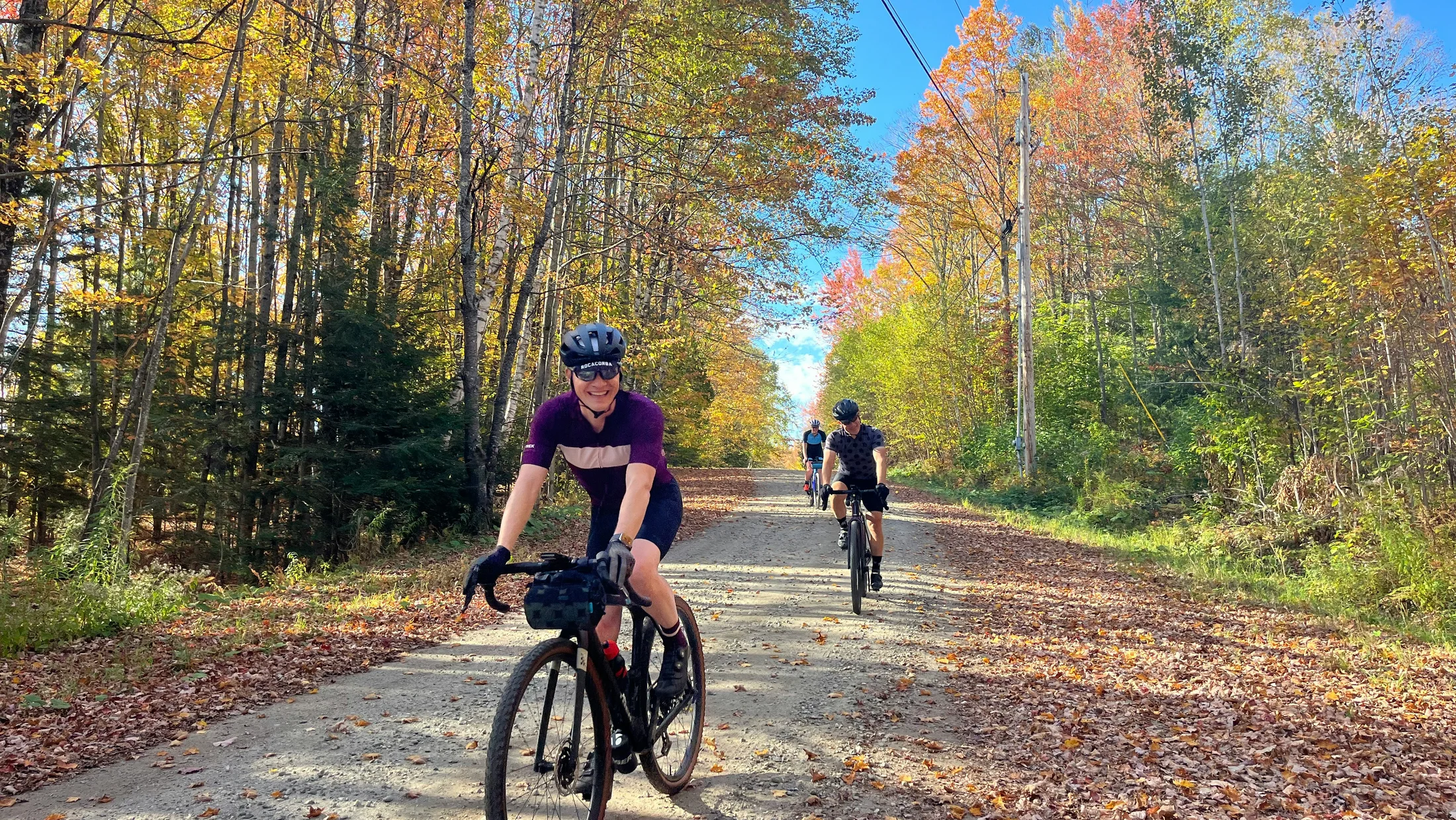
Vías verdes Spain are disused railway lines restored as traffic-free trails, turning steel corridors into safe paths through nature and heritage. They keep the gentle railway gradient (usually under 3%), add smooth surfaces, and preserve tunnels, stations, and viaducts that make every outing a journey through history. You ride or walk far from cars yet close to villages, orchards, and wetlands where local life still sets the pace.
You’ll cross mountain foothills in Asturias, olive seas in Andalusia, beech and oak woods in Navarra and Gipuzkoa, and coastal plains near the Ebro Delta. One moment you glide across a hundred-metre viaduct, the next you roll into a whitewashed town for a plate of local cheese. A faint breeze carries the cool scent of stone tunnels, and your wheels hum where trains once sang. Families, leisure riders, and committed tourers all find space here.
These greenways Spain differ from other cycle routes because they are predictable, signposted, and separated from traffic, with modest slopes ideal for children and e-bikes. The network, coordinated since the 1990s by Spain’s Fundación de los Ferrocarriles Españoles (Spanish Railways Foundation), now stretches beyond 3,000 km across 120+ itineraries, according to the programme’s published figures. That scale means real choice: short nature trails Spain for a Sunday picnic, multi-day cycle routes Spain for a touring week, and photo-rich walks to viaducts and gorges.
This Spain cycling guide focuses on scenery, distance, and difficulty so you can match the day to your group. You’ll find a quick-reference map by regions and a concise table, then 10 detailed route profiles with length, best sections, surfaces, and seasonal tips. Expect practical advice on when to go, how to get there, rentals, safety, accessibility, and how to split stages without stress. If you want an easy start, pick a riverside trail in spring; if you want a stretch, choose a rolling olive railway in autumn. Keep local communities in mind as you plan: these paths pass farms, towns, and protected habitats maintained by people who live here, and your visit supports their work. To price rentals and tours, compare options locally or explore curated experiences on Picuco.
Picuco te puede ayudar
Does something here catch your eye?
Tell us.
Write to us on WhatsApp or email: we answer questions, find the best options and help you sort out the booking.
Where To Find Them At A Glance
You can locate the 10 featured vías verdes across five big arcs of Spain. In the North, forested routes like Plazaola (Navarra/Gipuzkoa) and the Senda del Oso (Asturias) trace cool valleys. In the Centre, Madrid’s Aranjuez area hosts a short, family-friendly historic rail path linked to palace gardens. In the East, Girona’s Carrilet climbs gently toward extinct volcanoes, while the Ebro’s lower course offers wetland birdlife. In the South, Andalusia concentrates long olive-rail itineraries—the Vía Verde del Aceite and its Subbética section—and the dramatic Vía Verde de la Sierra in Cádiz/Sevilla. In the Northeast-to-Mediterranean belt, Ojos Negros connects Teruel’s highlands to Valencia’s citrus plains. Swallows stitch the sky above steel latticework as you scan your options.
Use this quick table to compare name, location, distance, typical difficulty, and best season. Difficulty here reflects gradient, surface, and exposure to heat or wind; always check local updates for closures or surface works via municipal tourism pages or the national Vías Verdes portal by the Fundación de los Ferrocarriles Españoles.
| Greenway (Vía Verde) | Province/Region | Distance (km) | Difficulty | Best season |
|---|---|---|---|---|
| Ojos Negros | Teruel–Valencia (Aragón/Comunitat Valenciana) | ~160 | Easy–Moderate | Spring, autumn |
| Vía Verde de la Sierra | Cádiz–Sevilla (Andalucía) | 36 | Easy | Spring, autumn, mild winter |
| Plazaola | Navarra–Gipuzkoa (Navarra/Euskadi) | ~44 (open sections) | Easy–Moderate | Late spring–early autumn |
| Vía Verde del Aceite | Jaén–Córdoba (Andalucía) | ~120 | Easy–Moderate (heat risk) | Spring, autumn |
| Carrilet Girona–Olot | Girona (Catalunya) | 57 | Easy | Spring, summer, autumn |
| Tren de la Fresa (Aranjuez) | Madrid (Comunidad de Madrid) | ~14–18 | Very Easy | Spring, autumn |
| Senda del Oso | Asturias (Principado de Asturias) | 36 (network) | Easy | Late spring–autumn |
| Vía Verde de la Subbética | Córdoba (Andalucía) | ~65 | Easy–Moderate | Spring, autumn |
| Sierra de la Demanda | Burgos (Castilla y León) | ~54 | Moderate | Late spring–early autumn |
| Vía Verde del Ebro (Baix Ebre) | Tarragona (Catalunya) | 26 | Easy | Spring, autumn, winter |
Tip: For current status of tunnels, lighting, or diversions, consult municipal tourism sites and the Vías Verdes Spain programme pages before you go. Families should favour shaded valleys; long-distance riders can chain routes like Carrilet I (Olot–Girona) with Carrilet II (Girona–Sant Feliu) for a weekend coast-to-inland traverse.
The 10 Most Beautiful Greenways: Detailed Route Cards
1.Ojos Negros: Spain’s longest greenway from highlands to orange groves
This is the giant of vías verdes Spain, a railway-turned-greenway running roughly 160 km from the Teruel plateau to Valencia’s Mediterranean lowlands. The line’s railway DNA means manageable gradients, dramatic cuts, and airy viaducts as you move from pine and cereal country to citrus and sea breezes. In the quiet between tunnels, the scent of warm thyme rises from dry slopes.
- Distance and surface: ~160 km; compacted gravel/asphalt mix, with urban connectors toward Sagunt.
- vías verdes distance and difficulty: Easy–Moderate; mostly 1–2% gradients, longer days require stamina.
- Best sections: Jérica–Segorbe for easy day rides with services; Sarrión–Teruel for highland scenery.
- Highlights: Historic stations, long viaducts near Albentosa, shallow rock cuttings, river crossings.
- Services: Bike rentals and cafés near Segorbe/Jérica; frequent fountains in towns; check tunnel lighting locally.
- Best time: Spring and autumn; summers are hot on exposed plateaus, winters can be frosty at altitude.
How to ride it:
- Day options: Base yourself in Segorbe or Jérica and do out-and-back segments of 25–40 km.
- Multi-day: 3–5 days for the full traverse if you average 35–60 km/day; arrange return via regional trains near Sagunt or private transfer.
- Who it suits: Tourers seeking Spain cycling guide benchmarks, e-bikers, and confident families on short sections.
Local note: You’ll pass farming towns where bakeries open early; buy local pastries and greet station volunteers who keep these stops alive.
2.Vía Verde de la Sierra: tunnels and viaducts between Cádiz and Sevilla
This 36 km gem strings together 30 tunnels and 4 grand viaducts between Puerto Serrano and Olvera along the old Jerez–Almargen line. Ribera woodlands shade the Guadalete river while limestone bluffs frame the path, and griffon vultures circle near the Peñón de Zaframagón reserve. Cool air breathes out of the tunnel mouths like a natural fan.
- Distance and surface: 36 km; fine compacted gravel/asphalt, well signposted.
- Difficulty: Easy; gentle gradient and many shaded stretches.
- Best sections: Olvera–Zaframagón (vulture viewing and big spans); Puerto Serrano–Coripe for riverside riding.
- Highlights: Zaframagón Nature Reserve observatory, Coripe Station, Navalagrulla and Guadalete viaducts.
- Services: Stations-turned-inns at Olvera and Coripe, bike hire at trailheads, picnic areas.
- Best time: Spring for flowers and water flow; autumn for stable weather; mild winters are rideable.
How to ride it:
- Day option: Do the whole line one-way with a pre-arranged shuttle; 3–4 hours easy pace with stops.
- Family tip: Start at Coripe toward Zaframagón for short, scenic out-and-back segments (10–20 km).
- Photo spots: Stop mid-span on the navalagrulla viaduct and at Zaframagón’s hide; carry a headlamp for unlit tunnels.
Community note: Respect farm crossings and yield to livestock; local cooperatives maintain parts of the corridor and welcome visitors who tread gently.
3.Plazaola: forest, stone bridges, and Basque-navarre railway heritage
The historic Plazaola line once linked Pamplona and San Sebastián; today, forested greenway sections total roughly 44 km across Navarra and Gipuzkoa with some temporary closures after heavy rains. Expect beech, oak, and alder galleries, stone bridges, and cool tunnels along rivers like the Leitzaran. Leaves whisper against your helmet as you roll in dappled light.
- Distance and surface: ~44 km open in sections; surfaces vary from asphalt to compacted earth.
- Difficulty: Easy–Moderate; short ramps at diversions around landslides; check status before departure.
- Best sections: Andoain–Leitza (Gipuzkoa) for continuous forest and heritage; Lekunberri-based loops (Navarra) for families.
- Highlights: Leitzaran river corridor, small viaducts, tunnel clusters, restored stations with exhibits.
- Services: Visitor centres at Andoain/Lekunberri, rentals in towns, frequent picnic tables.
- Best time: Late spring to early autumn; winters are wet and tunnels can be chilly.
How to ride it:
- rutas en bici vías verdes: From Andoain, plan a 30–40 km out-and-back to enjoy the deepest forest stretch without logistics complexity.
- For walkers: Start in Lekunberri for 8–15 km family hikes to scenic bridges.
- Families: Bring lights and extra layers; children love counting tunnels but may tire on gravel patches.
Source note: For current closures and diversions, look up municipal communications in Andoain, Leitza, and Lekunberri and the Vías Verdes Spain portal managed by the Fundación de los Ferrocarriles Españoles.
4.Vía Verde del Aceite: olive seas and iron heritage between Jaén and Córdoba
Running roughly 120 km along the old Jaén–Puente Genil railway, this is one of the best vías verdes Spain for long, sunlit horizons and white towns perched above olive terraces. Iron trusses leap ravines, and former stations serve as cafés and simple lodgings across both provinces. The warm scent of crushed olives drifts from mills in harvest season.
- Distance and surface: ~120 km; mostly compacted gravel/asphalt, with excellent signage.
- vías verdes difficulty: Easy–Moderate; steady gradients, but heat and exposure increase effort in summer.
- Best sections: Jaén–Martos for gentle starts and services; Zuheros–Doña Mencía for Subbética cliffs and classic photos.
- Highlights: Iron viaducts, Subbética Natural Park viewpoints, station museums, endless olive groves.
- Services: Multiple trailheads, rentals in larger towns (Jaén, Lucena), rural guesthouses along the way.
- Best time: Spring (flowers, mild temps) and autumn (clear air); avoid midday in July–August.
How to ride it:
- Day trips: Base in Doña Mencía or Zuheros for 20–40 km circuits with short climbs to cliff lookouts.
- Multi-day: 2–4 days with 35–60 km stages; plan early starts and water refills every village.
- Heat management: Carry 2–3 litres per rider in warm months; seek shaded breaks at stations or grove edges.
Local note: Many stretches cross olive estates; greet workers, avoid blocking farm tracks, and sample oils at cooperatives when available.
5.Carrilet Girona–olot: volcanic landscapes and bridges on a gentle climb
The Ruta del Carrilet I links Girona to Olot over 57 km, following the Ter and Brugent valleys into the Garrotxa Volcanic Zone Natural Park. It’s an easy, green, and cultural line with towns, bridges, short tunnels, and train stations reimagined as cafés. Morning mist beads on railings as you pedal past fields and ash-grey lava outcrops.
- Distance and surface: 57 km; mostly compacted gravel/asphalt, well maintained and signed.
- Difficulty: Easy; modest net climb Girona→Olot, or ride downhill from Olot to Girona.
- Best sections: Anglès–Les Planes for river scenery; Olot–Sant Joan les Fonts for volcanic features.
- Highlights: Medieval Girona, Olot’s market, Garrotxa beechwoods, small tunnels and bridges.
- Services: Ample rentals in Girona and Olot, frequent stations with water and food, good public transport at both ends.
- Best time: Spring and autumn; summer is fine with earlier starts; winter is rideable most days.
How to ride it:
- Family option: Split in two 25–35 km days with an overnight near Les Planes d’Hostoles.
- Connections: Combine with Carrilet II (40 km) to Sant Feliu de Guíxols for an inland-to-sea weekend.
- Culture stops: Park bikes to tour Girona’s old quarter or Olot’s volcanic museum; lock at visible racks.
Community note: Respect shared use—locals commute and jog here—keep right and signal when overtaking.
6.Tren de la Fresa (aranjuez): short, historic, and family-friendly near Madrid
Aranjuez’s royal gardens and historic railway give shape to a short, very gentle path often called the Senda or Vía Verde del Tren de la Fresa in local signage. Expect 14–18 km of easy riding and walking on mixed-surface paths that link the palace area with old service tracks toward Algodor and the Tagus riverside. The smell of damp poplars and irrigated fields hangs in the air near canals.
- Distance and surface: ~14–18 km depending on chosen loop; gravel, earth, and short urban sections.
- Difficulty: Very Easy; flat, calm, with frequent rest spots.
- Best sections: Palace gardens perimeters and canal paths; quiet stretches toward Algodor for a rail feel.
- Highlights: Aranjuez Royal Palace and gardens, historic station, canals, fruit orchards.
- Services: Bike rentals in town, cafés everywhere, frequent train access from Madrid (Cercanías).
- Best time: Spring (blossom) and autumn (soft light); summer early mornings.
How to ride it:
- With kids: Plan a 6–12 km loop including garden views and a canal picnic; avoid muddy days after heavy rain.
- Rail heritage: Visit Aranjuez station’s exhibits if open and look for old sidings; this is more cultural stroll than wilderness ride.
- Access: Take the Madrid–Aranjuez commuter train with bikes at off-peak times; check carriage rules.
Note: This family circuit is not a long intercity vía verde; confirm current local route maps at Aranjuez tourism or municipal websites to match your group.
7.Senda del Oso: waterfalls, wildlife, and smooth surfaces in Asturias
The Senda del Oso is a 36 km greenway network on a former mining railway south of Oviedo, with two arms meeting near Entrago/Teverga and a branch to Quirós. Limestone gorges, small waterfalls, and chestnut woods frame a path that rarely leaves the river’s side. Water murmurs below the railings as you pass the Cueva Huerta area and old bear enclosures that once housed rescued Cantabrian brown bears.
- Distance and surface: ~36 km network; mostly asphalt or very smooth compacted gravel.
- Difficulty: Easy; low gradients, excellent for trailers, child seats, and mobility scooters in many parts.
- Best sections: Tuñón–Proaza for families; Proaza–Entrago for wilder gorge scenery.
- Highlights: Bear viewing points (interpretive), short tunnels, riverside rest areas, mountain hamlets.
- Services: Rentals at trailheads (Tuñón/Proaza), cafés in villages, frequent fountains.
- Best time: Late spring to autumn; winters are lush but wetter; mornings are calmer for wildlife.
How to ride it:
- Family day: 10–20 km out-and-back from Tuñón with ice cream stops; bring lights for a couple of tunnels.
- Nature-watch: Dawn and dusk give better bird and deer movement; keep voices low near hides.
- Accessibility: Many segments have barrier-free access; confirm specific ramps and surfaces with local offices if needed.
Community note: Stay on the path; this valley’s recovery is the result of local conservation and active rural life.
8.Vía Verde de la Subbética: cliffs, white towns, and olive horizons
Within Córdoba’s Subbética region, this ~65 km stretch forms the most dramatic heart of the broader Vía Verde del Aceite, looping past towns like Doña Mencía, Zuheros, and Luque. Expect cliff-side cuttings, iron spans, and sudden views of white towns against dark limestone. Warm air carries the scent of herbs from dry banks as you roll into a station-turned-café for a cool drink.
- Distance and surface: ~65 km; excellent compacted surface and signage, family-friendly trailheads.
- Difficulty: Easy–Moderate; steady railway grades but prolonged exposure and some windy saddles.
- Best sections: Zuheros–Doña Mencía for cliff photos and the Zuheros gorge; Cabra–Lucena for services.
- Highlights: Subbética Geopark viewpoints, station museums, olive-mill visits, white villages.
- Services: Rentals and cafés at multiple stations, rural inns and casas rurales in towns.
- Best time: Spring and autumn; sunsets in October–November are spectacular.
How to ride it:
- One-day highlight: Park at Doña Mencía and ride 30–40 km out-and-back toward Zuheros and Luque.
- Weekend: Sleep in Zuheros or Cabra to split the line into two easy days with cultural visits.
- Extras: Book olive-oil tastings and short hikes into the Zuheros gorge; carry cash for rural cafés.
Local courtesy: Slow near farm crossings; greet residents—Subbética hospitality is part of the route’s charm.
9.Vía Verde de la Sierra de la Demanda: highland views and cool air
East of Burgos, the Sierra de la Demanda greenway covers around 54 km along a highland railway with notable climbs when joined from feeder roads. Forests, lakes, and mountain meadows alternate with viaducts and wide-angle views, making it a favourite for fitter riders and photographers. Pine resin scents the air as wind brushes the grass on open embankments.
- Distance and surface: ~54 km; mixed compacted gravel and asphalt, occasional rougher patches.
- Difficulty: Moderate; altitude, cooler weather, and occasional ramps if you enter from connecting roads.
- Best sections: Arlanzón–Pineda de la Sierra for lakeside and forest; Pineda–Barbadillo for open vistas.
- Highlights: Arlanzón Reservoir views, stone viaducts, restored station buildings, quiet highland valleys.
- Services: Sparse; plan food/water stops in villages; limited rentals—bring your bike if possible.
- Best time: Late spring to early autumn; avoid snowy/icy spells and check forecasts.
How to ride it:
- One-day strong ride: 40–60 km out-and-back from Pineda de la Sierra with photo stops at reservoirs.
- Multi-day: Pair with nearby caminos naturales for a 2–3 day mountain loop if you’re experienced.
- Clothing: Carry a wind layer year-round; mountain weather shifts quickly.
Respect: Trails cross livestock zones—close gates, pass slowly, and keep dogs leashed where allowed.
10.Vía Verde del Ebro (baix Ebre): riverside ease and birdlife near the Delta
South of Tarragona, the Baix Ebre greenway rolls about 26 km between Tortosa and L’Aldea–Amposta along the Ebro’s fertile plain, connecting to tracks and quiet lanes that lead toward the Delta’s wetlands. Flat gradients, big skies, and abundant birdlife make this a gentle, absorbing ride. Reeds flicker in the breeze as herons lift lazily from irrigation ditches.
- Distance and surface: 26 km core greenway; smooth asphalt/compacted gravel.
- Difficulty: Easy; very flat, exposed to wind in some sections.
- Best sections: Tortosa–Amposta for bridges and river views; side trips toward Deltebre for wetlands.
- Highlights: Riverfront promenades, historic Tortosa, bird observation points, seasonal rice fields nearby.
- Services: Plenty in Tortosa/Amposta; rentals available; trains connect to Tortosa.
- Best time: Spring and autumn for migratory birds; winter is mild and rideable; summers are hot at midday.
How to ride it:
- Family plan: 10–20 km out-and-back with riverside snacks; pack binoculars for kids.
- Birding: Check seasonal species calendars and consider short detours into the Ebro Delta Natural Park.
- Route tie-ins: The river corridor links with the long-distance Camino Natural del Ebro
GR-99for extended touring.
Stewardship: Stay on marked paths in wetland zones; these are working landscapes where agriculture and conservation meet.
Essential Info and Easy Add-ons
Greenway signage is consistent and simple: look for brown/green “Vía Verde” panels, kilometre posts, and barriers where the rail line once met roads. Symbols indicate tunnels, steep cuts, and service areas; trailhead boards summarize distance and safety rules. If you see temporary signs, they often redirect around works or rockfall—follow them even if your GPS says otherwise. Sun warms the timber of old sleepers stacked by a wayside sign as you tighten your helmet.
When to go:
- North (Asturias, Navarra/Gipuzkoa): Late spring to early autumn is best; winters are wet and tunnels drip.
- South (Andalucía): Spring and autumn shine; start early if you ride in summer.
- East (Catalunya, Valencia): Spring/autumn are ideal; coastal plains ride year-round, but wind matters.
- Highlands (Burgos, Teruel): Late spring–early autumn; mornings can be cold even in June.
Getting there:
- By train: Many greenways connect to regional rail at a town near one end (e.g., Girona, Tortosa, Aranjuez, Segorbe). Bikes are usually allowed off-peak; confirm rules and capacity.
- By bus: Intercity coaches can carry bikes in luggage bays if the front wheel is removed; check policies in advance.
- By car: Most trailheads have parking at former stations; arrive early on sunny weekends.
Where to stay:
- Casas rurales (rural guesthouses) put you in villages steps from the trail.
- Small hotels and station hostels feature along popular lines (e.g., Vía Verde de la Sierra).
- Campgrounds appear near rivers or park edges, especially in Girona and the Ebro area.
- Book ahead for spring weekends in Andalusia and summer in Girona/Asturias.
Norms and permissions:
- No special permit is needed for cycling or walking on vía verde corridors, but follow local bylaws posted at trailheads.
- Use lights in tunnels; some are lit on timers, others are dark—carry a front light.
- Speed limits often apply near towns (e.g., 10–20 km/h); share the path with walkers, kids, and horses.
- Keep dogs leashed where required and always bag waste.
- Do not enter fenced railway heritage zones or active maintenance areas.
Activities to layer onto your day:
- Cycling: Ideal for 10–60 km days depending on fitness; e-bikes extend range without strain.
- Walking/hiking: Choose scenic 6–15 km out-and-backs to viaducts and gorges.
- Birdwatching: Prime on the Ebro and wetlands; bring binoculars and check migration calendars.
- Photography: Early and late light on viaducts, stations, and olive slopes offers clean compositions.
- Heritage interpretation: Many stations house exhibits on the railway, mining, or local crafts—short visits enrich the ride.
Who fits what:
- Families: Flat, shaded valley segments like the Senda del Oso or Plazaola; plan frequent stops and playground time.
- Leisure cyclists: Carrilet Girona–Olot or Vía Verde de la Sierra—smooth surfaces, great cafés.
- Tourers: Ojos Negros and the Aceite/Subbética combination—longer days with services.
- Runners: Early mornings on shaded sections; mind tunnel footing and cyclists.
Respect the communities that keep these routes alive: buy locally, yield at farm crossings, and greet residents. The more you align your pace with the territory, the richer the day feels.
Plan Your Day: Stages, Rentals, Gear, Safety, and Access
Duration and pacing:
- Families with children 6–10: 10–20 km/day with snack and play stops.
- Leisure riders: 30–50 km/day on easy vías verdes distance profiles.
- Tourers/e-bikers: 50–90 km/day depending on wind, heat, and luggage.
- Walkers: 8–20 km/day on level surfaces; choose tunnel-light sections if kids are sensitive.
How to split stages:
- Identify trailheads with parking or rail access (e.g., Olvera, Coripe; Girona, Olot; Tuñón, Proaza).
- Group memorable features into each day (viaduct + village + viewpoint).
- Plan A/B turnarounds for out-and-backs in case of heat, headwind, or tired legs.
- Reserve lodging near station nodes to simplify starts and finishes.
Parking and transport:
- Leave your car at a station lot and ride out-and-back, or pre-arrange a shuttle/taxi for one-way traverses.
- Note return options: regional trains near Girona, Aranjuez, Tortosa, and Valencia; buses may accept bikes with prior notice.
Bike rental tips:
- Types: City/trekking bikes for smooth surfaces, gravel/MTB for mixed sections, e-bikes to flatten longer days.
- Booking: Reserve 48–72 hours in advance on popular weekends; ask for helmets, lights, and a basic tool kit.
- Insurance: Confirm theft/damage coverage and deposit terms; photograph the bike at pickup.
Essential gear checklist:
- Helmet, front/rear lights (mandatory for tunnels)
- Two water bottles or hydration pack; electrolytes in hot months
- Snacks/lunch; cash for rural cafés
- Basic tools: multi-tool, tyre levers, pump, spare tube
- Sun protection: sunscreen, cap, sunglasses, lightweight sleeves
- Layers: wind shell; rain jacket in northern routes
- Map/GPS with offline basemaps; power bank
- First aid: plasters, antiseptic wipes, blister care, pain relief
- ID, phone, small trash bag to pack out waste
Safety and first aid basics:
- Ride at a speed that allows you to stop within your sightline, especially when exiting tunnels.
- Call emergency services via 112 in Spain; provide closest kilometre post or nearest station name.
- Clean and cover minor cuts; cool heat stress with shade, water, and electrolytes; if symptoms persist, stop the activity.
Accessibility for families and mobility:
- Many vías verdes offer barrier-free trailheads, ramps, and smooth asphalt (e.g., Senda del Oso sections).
- For trailers and cargo bikes, confirm gate widths and bollard spacing at stations.
- In summer south routes, schedule siestas—mornings 08:00–11:30 and late afternoons 18:00–20:30 are safest.
Travel with kids or groups:
- Assign roles: navigator, safety sweep, snack captain.
- Use clear regroup points—end of tunnels, start of viaducts, or station cafés.
- Celebrate milestones at stations with small treats; it keeps morale high and supports local businesses.
Adapt to fitness:
- Shorten the day with out-and-backs rather than forcing a one-way in rising wind or heat.
- On e-bikes, keep eco modes for range; charge overnight and carry the charger to lunch stops if needed.
- Think in effort, not only kilometres: shade, wind, and surface matter as much as distance.
Frequently Asked Questions
Are Spain’s vías verdes safe?
Yes. They’re traffic-free corridors with gentle grades and clear signage, often fenced at road crossings. Use lights in tunnels, moderate speed near towns, and brief kids on sharing the path. In busy seasons, ride early for quieter hours.
Can I use a road bike on greenways?
Often yes, on asphalted sections like parts of the Carrilet, Senda del Oso, and Baix Ebre. But many vías verdes have compacted gravel; 28–32 mm tyres improve comfort and reduce punctures. Check the surface of your chosen section before committing to skinny tyres.
Do I need to book accommodation in advance?
In spring and autumn for Andalusia and in summer for Girona/Asturias, book 1–2 weeks ahead, especially weekends. Rural guesthouses and small hotels near stations fill quickly. For day trips, no bookings are needed—just arrive early for parking and rentals.
Can I bring my dog?
Generally yes, on a leash, respecting posted bylaws and shared-use etiquette. Carry water and waste bags, avoid the hottest hours, and keep a safe distance from livestock and wildlife. Some tunnels can spook nervous pets—bring a light and move calmly.
How do I get back to the start after a one-way ride?
Use regional trains where available (e.g., Girona, Aranjuez, Tortosa, Valencia area) or pre-book a taxi/shuttle that accepts bikes. Many riders also plan out-and-backs to avoid logistics. If using buses, confirm bike policies and bring a cover or remove the front wheel.
What is the best season to ride?
Spring and autumn offer mild temperatures across most routes. Northern routes ride well in summer with earlier starts; southern routes can be hot—ride mornings and evenings. Winter is feasible on coastal plains like Baix Ebre and on sunny Andalusian days.
Book your experience — discover outdoor activities in Spain with Picuco’s verified local partners.
Conclusion
Across mountains, olive seas, forests, and river plains, these 10 greenways distil what makes vías verdes Spain special: safe gradients, living railway heritage, and landscapes that change with each kilometre. You can choose an easy family loop in Aranjuez, a two-day Girona–Olot ride with volcanic stops, a photo-rich day under vultures in Cádiz, or a four-day traverse from Teruel’s high plateau to Valencia’s orange groves. A cool breath of air awaits in every tunnel, and each restored station offers a pause where past and present meet.
Pick a route that matches your distance and difficulty, plan water and shade, and support the communities that maintain the path—buy olive oil in Subbética, taste cheese in Asturias, and chat with the volunteers at small station museums. If you travel with kids, keep it playful; if you tour for days, keep it steady; if you photograph, chase first light on viaducts. When you are ready, reserve your bikes, confirm train times, and download your GPX so your day flows at your own pace.
We’d love to hear how it goes. Share your favourite stretch, your best picnic spot, or the tunnel that made you smile, and subscribe for more carefully selected rural routes and nature escapes across Spain.