Why The Ruta Del Cares Deserves Your Full Attention
This famous gorge walk rewards good planning. The Ruta del Cares runs through Picos de Europa National Park, a limestone world of cliffs and cold, clear water. The air smells like wet rock in the morning. You’ll find here a complete, practical guide to distances, variants, parking, timing, and safety so you can walk it at your own pace.
This is a day hike that suits prepared walkers. The route follows a historic maintenance path carved for a hydroelectric canal between Poncebos (Asturias) and Caín (León). Sun bounces off white walls while the river murmurs far below. Read on for how to choose your start point, when to go, and how to avoid crowds.
Families, couples, and small groups will all enjoy the drama if they respect its exposure—paths with drops at the side. Loose gravel crunches under boots as vultures circle overhead. You’ll learn what to carry, how to manage heat, and when to call it a day for safety.
The Senda del Cares in Context
The Senda del Cares began as a service path for the canal feeding the Camarmeña–Poncebos hydro plant (built 1916–1921; widened 1945–1950). The route links Poncebos (Cabrales, Asturias) with Caín (Valdeón, León) right through the Cares Gorge. Wind cools the tunnels while the canal hums beside you. Photographers come for knife-edge limestone, emerald pools, and stone bridges.
Picos de Europa National Park straddles Asturias, Cantabria, and Castilla y León. Here the Cares River saws into the Central and Western massifs, creating a 12 km balcony path one way. Sunlight stripes the canyon floor at midday like a sundial. The path’s combination of history, access, and scenery explains its fame across Spain and beyond.
Expect a non-technical track with sections of “exposure”—a hiking term meaning a fall hazard beside the trail without handrails. The cliff feels close as your steps echo in tight sections. This is why planning, early starts, and calm pacing matter.
What You’ll Find Here And How To Use It
You want clarity, not clutter. This guide covers essential facts (where it is, duration, difficulty), how to get there, parking, route variants, highlights, gear, safety, and FAQs. Heat shimmers above the pale rock by noon. Skim “Information essentials” and “How to get there” for quick planning, then dive into “Route description and variants” if you’re comparing options.
If you need the big picture fast, focus on:
- Best season and typical times
- Parking at Poncebos/Caín and return logistics
- One-way versus out-and-back options
For deeper detail on the Ruta del Cares, use:
- Step-by-step route breakdown
- Points of interest and photo spots
- Gear checklists and family tips
Keep this open while you plan; it reads like a field note with numbers you can trust. Your pack feels lighter when your plan is solid. When you’re ready, lock accommodation and daylight timing first.
Picuco te puede ayudar
Does something here catch your eye?
Tell us.
Write to us on WhatsApp or email: we answer questions, find the best options and help you sort out the booking.
The Essentials: Where It Is, How Long It Takes, And When To Go
Start by placing it on the map. The route spans Asturias and León, between Poncebos (Concejo de Cabrales) and Caín (Municipality of Valdeón), inside Picos de Europa National Park. A narrow road clings to the valley as the gorge tightens. On printed maps you’ll often see the path labeled as the Cares Gorge hike or the PR-PNPE-3 in park materials; it tracks the canal and river through the Desfiladero del Cares.
Distances and elevation decide your day. One way measures about 12 km between trailheads; a full out-and-back totals roughly 24 km. The first 2 km from Poncebos climb steeply in zigzags to a balcony level, then the route undulates before a gentle descent into Caín. Your breath fogs in cool tunnel mouths even in summer. Expect cumulative elevation gain of 300–500 m each way depending on direction and GPS source; none of it is technical, but exposure and heat raise the effort.
Timing depends on pace and photo stops:
- One-way, steady pace: 3–4 hours
- Out-and-back, steady with short breaks: 6–7 hours
- Out-and-back with long photo/picnic stops: 7–9 hours
“Exposure” means a fall risk beside the path; the track is typically 1–1.5 m wide with drop-offs and limited rails. A stiff breeze brushes the gorge like a bellows. People with severe vertigo often prefer the Caín side for its gentler start or choose a partial out-and-back from either end.
Season matters. May–June and September–October offer cooler temperatures, longer daylight, and fewer storms; July–August brings heat and peak crowds; November–March can mean ice, snow patches, and occasional rockfall or road closures on the León side. The river smells metallic-cold after rain. Always check the Picos de Europa National Park advisories and local road updates before you go.
Daylight planning helps:
- Late spring: sunrise ~6:50–7:00, sunset ~21:30–22:00
- Mid-summer: sunrise ~6:40, sunset ~21:50–22:10
- Early autumn: sunrise ~8:00, sunset ~20:00
- Winter: sunrise ~8:30–8:45, sunset ~17:45–18:00
These are Spain-wide approximations; verify for your dates. Sun warms the south-facing walls quickly by mid-morning. Start early to maximize cool shade and headroom for breaks.
Weather risks to note:
- Heat stress and dehydration in summer
- Icy patches in shaded sections in winter
- Sudden storms with strong gusts funneling through the gorge
- Rockfall after heavy rain or freeze–thaw cycles
Carry layers and a light rain shell year-round, and postpone in high wind warnings. The white roar of the river grows after rain, a hint to dial back ambitions. If in doubt, choose a shorter section and return the same way.
Getting There: Roads, Public Transport, And Parking
Reaching trailheads is straightforward if you know the mountain roads. Poncebos is the classic starting point on the Asturian side; Caín sits at the bottom of Valdeón in León. Diesel and brake pads smell faint on long descents. Decide your start by considering parking pressure, road closures, and your return plan.
By Car: Main Routes And Road Notes
Driving offers the most flexibility. From Oviedo, follow A-64/N-634 to Arriondas, then AS-114 via Cangas de Onís and Arenas de Cabrales; at Arenas take the AS-264 spur to Poncebos (about 2 h total in light traffic). The road threads between stone walls as cows graze above. From Santander, use A-8 to Unquera, then N-621 to Panes and AS-114 toward Arenas, finishing on AS-264 (around 2 h).
From León to Caín (how to get to Caín): take N-621 toward Riaño, then LE-244 to Posada de Valdeón and LE-2703 down to Caín (about 2.5 h from León city). Pine resin scents the air near higher passes. This final descent is narrow and winding, with occasional winter closures for snow or ice—check with Diputación de León or local advisories before departure.
From Madrid to Poncebos, allow 5–5.5 h via A-1 to Unquera and then inland as above; to Caín, plan similar time via A-6/N-120 to León, then N-621/LE-2703. Plan fuel stops before the valleys. Many stretches lack mobile coverage, so download offline maps in advance.
Parking Smart: Poncebos, Caín, And Peak Season Tactics
Parking fills early in summer and long weekends. In Poncebos, the main lots spread around the Bulnes funicular base and along the AS-264, with limited marked spaces and informal gravel areas. Morning air smells of coffee from early bars as engines idle. Locals and rangers sometimes regulate shoulder parking to keep traffic flowing; respect signage to avoid fines or towing.
Aparcamiento Poncebos tends to fill by 8:30–9:00 in July–August and sunny spring/autumn weekends. Aim to arrive by 7:30 for stress-free parking, or start from Arenas and taxi in. Dust rises in low light as the first hikers shoulder packs. Private paid parking appears seasonally in Arenas de Cabrales; confirm on-site and consider a short transfer to Poncebos.
Caín has small municipal and roadside areas inside the village limits, sometimes with attendants and a modest fee in peak season. Swallows dip low over the river at dawn. Space is extremely limited in August; overnight guests have a clear advantage. If you plan a one-way Poncebos→Caín, consider parking in Arenas or Posada de Valdeón and using a pre-booked taxi to the start.
Buses, Trains, And Transfers
Public transport exists but demands coordination. On the Asturian side, buses run to Cangas de Onís and Arenas de Cabrales year-round, with limited or seasonal services extending to Poncebos; check ALSA and the Consorcio de Transportes de Asturias for current timetables. Diesel engines thrum softly in misty mornings. If no direct bus reaches Poncebos on your date, taxi the final 6–7 km from Arenas.
Trains can help position you on the coast. Renfe (FEVE narrow-gauge lines) connects cities like Oviedo, Gijón, and Santander with towns such as Llanes or Unquera; from there, use a bus to Arenas and a taxi to Poncebos. The carriage windows frame green valleys and stone villages. On the León side, seasonal buses may reach Posada de Valdeón from Riaño or León; from Posada, it’s a short but steep road transfer to Caín—pre-book a taxi.
For one-way hikes, arrange a return transfer in advance. Local taxis operate from Arenas de Cabrales, Cangas de Onís, Posada de Valdeón, and occasionally Caín in season. The smell of warm brakes marks the end of a descent where a driver awaits. Build a 20–40 minute buffer into pick-up times, and share your live location when coverage allows.
Where To Stay: Best Bases In Poncebos, Caín, And Nearby Towns
Sleeping close to the trailhead simplifies everything. Choose between tiny Poncebos, even smaller Caín, or service-rich hubs like Arenas de Cabrales and Cangas de Onís. Night air carries the river’s cool breath through open windows. Book early for weekends and summer, and match your base to your start time and family needs.
Poncebos: Overnight At The Doorstep
Poncebos is minimal but efficient. You’ll find a handful of small inns and casas rurales within a few minutes’ walk of the start, with more options 5–10 km away in Camarmeña and Arenas. The gorge hums softly after sunset below the road. Staying here lets you park early, step straight onto the Cares Gorge hike, and beat the heat.
Pros:
- Walk to the trail in minutes
- Early parking and dawn starts
- Quiet nights, starry skies
Cons:
- Very limited beds and dining options
- Prices can rise on peak dates
- Requires early booking for July–August
Request early breakfasts or packed lunches if you plan a sunrise start. Damp stone smells fresh before the day warms. If places in Poncebos are full, look to Arenas de Cabrales and budget 15–20 minutes’ drive at first light.
Caín: Sleep Where The Gorge Narrows
Caín sits literally inside the gorge. Small guesthouses and rural rooms cluster along the river, plus a few cafes and shops open in season. Water burbles past terraces where boots dry in the evening. Ending your day here means finishing at your bed, shower, and meal without a drive.
Pros:
- Finish-line comfort for one-way hikers
- Short stroll to the most photogenic tunnel section
- Cooler evenings beside the water
Cons:
- Tiny capacity; high demand in August
- Road is narrow and can close in winter
- Return logistics need planning if your car is elsewhere
Reserve months ahead for mid-summer weekends. Swifts loop under the bridges as diners linger outside. If you plan Caín→Poncebos one-way, consider leaving your car in Posada de Valdeón or arranging a morning taxi drop.
Nearby Hubs: Arenas, Cangas, And Covadonga Area
If you prefer more choice and services, base in Arenas de Cabrales or Cangas de Onís. Both offer supermarkets, pharmacies, and many eateries, plus family-friendly lodging and parking. Woodsmoke drifts from grills on cool evenings as chatter fills plazas. These towns work well for multi-night stays combining the Ruta del Cares with Lagos de Covadonga or short valley walks.
- Arenas de Cabrales: closest hub to Poncebos (6–7 km), great for early drives and post-hike meals.
- Cangas de Onís: larger selection, good transport links, ideal for families and rest days.
- Covadonga area: scenic stays if you plan to visit the sanctuary and lakes on adjacent days.
When to choose these bases:
- You want flexible dining times and shops
- You’re traveling with children and need space and services
- You’re planning multiple hikes or a mixed itinerary (culture + nature)
Use the table below to compare at a glance.
| Base | Distance to trailhead | Parking ease | Atmosphere | Best for |
|---|---|---|---|---|
| Poncebos | 0–1 km (walk) | Very limited in peak | Quiet, tiny | Dawn starters, photographers |
| Caín | 0–1 km (walk) | Very limited in peak | Immersive gorge | One-way finishers, couples |
| Arenas de Cabrales | 6–7 km to Poncebos | Easier, some private | Small town | Families, variety |
| Cangas de Onís | ~30 km to Poncebos | Easier | Lively, services | Multi-day stays |
Route Options: Main Track, One-way Plans, Reverse, And Short Alternatives
You can walk the full traverse, pick a side for a shorter out-and-back, or organize a one-way with a ride back. The limestone glows pink at sunrise along the high walls. Choose based on fitness, heat, and comfort with exposure.
1.Full Traverse Poncebos–caín: Step By Step
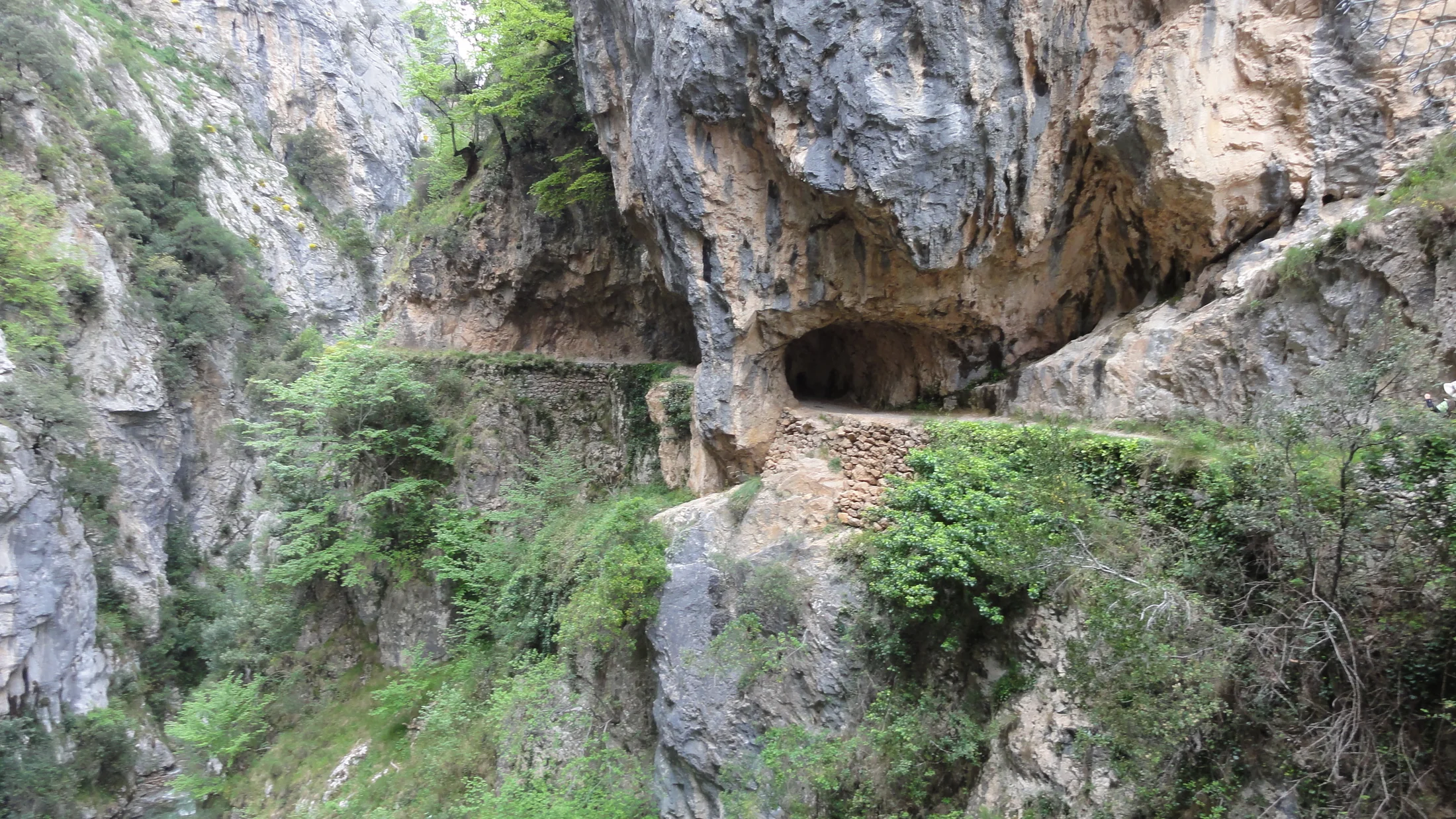
The Ruta del Cares in full is a classic transect between Asturias and León. From Poncebos, cross the river and climb steep zigzags for about 2 km to gain the balcony level; early shade and cool rock help here. Your breath puffs in little clouds on crisp mornings. After the climb, the path contours the cliff for several kilometers beside the canal, with occasional short unlit tunnels—carry a headlamp for comfort.
Landmarks come steadily:
- Balcony terraces with views back to Poncebos (~km 2–3)
- Canal maintenance huts and carved galleries (~km 5–7)
- Puente Bolín, a stone bridge spanning a narrow cleft (~km 7–8)
- Puente de los Rebecos near the León side (~km 10–11)
- Final tunnels and narrowing gorge into Caín (~km 11–12)
Expect 3–4 hours one way at steady pace, with cumulative ascent of roughly 300–500 m. A faint breeze funnels through the tightest narrows like a whisper. The walking is non-technical but often exposed; take care on loose gravel and when passing others on narrow edges. In summer, the Poncebos climb is best tackled before the sun hits; in autumn, carry a warm layer for shaded sections that stay cool all day.
2.One Way Only (poncebos Toward Caín) And Return Options
Walking only the outward leg reduces fatigue and exposure time. Start from Poncebos at first light to enjoy the climb in shade, then continue steadily to arrive in Caín by midday or early afternoon. The river’s constant rush steadies your rhythm. Once in Caín, plan one of three returns:
- Pre-booked taxi back to Poncebos or Arenas de Cabrales
- Seasonal transfer services connecting Valdeón and Cabrales (availability varies)
- Two-car shuttle: drop one car in Caín or Posada de Valdeón, then drive to start
Each choice has trade-offs. A taxi costs more but offers flexibility; a two-car plan demands careful key and time coordination; transfers may sell out or not operate off-season. Sun glitters off the water as you celebrate with a cold drink in Caín. If your car remains in Asturias, allow 1.5–2.5 hours for the mountain roads on the return drive and carry a wind layer for potential waits in the shade.
3.Reverse Direction And Combinations With Nearby Trails
Starting in Caín changes the day’s profile and feel. The first kilometers near Caín are gently graded and scenic, making this direction friendlier for anyone unsure about exposure at the start. Wet limestone smells earthy inside the hewn tunnels. You’ll save the steeper descents for the end as you drop into Poncebos, which can be kinder on hot afternoons if you began very early.
Combinations to consider if you crave more:
- From Poncebos, pair a short Bulnes visit on a separate day rather than the same; combining both makes for a punishing schedule.
- From Valdeón, add an evening stroll to village viewpoints for sunset over the Central Massif.
- Confident hikers can extend short spurs to marked miradores off the main path where signposted, but never take goat tracks or unmarked ledges.
Use official park signage and PR waymarks where present; “PR” stands for pequeño recorrido, a short-distance trail classification in Spain. A raven’s croak carries across the void as light fades from the canyon. Reverse logistics mirror section 2: arrange return transport or a two-car setup if you do not plan an out-and-back.
4.Short Sections, Family-friendly Outings, And Unofficial Shortcuts
You don’t have to do it all to taste the gorge. Two common short options let you enjoy highlights without committing to 24 km. Cool shade hugs the cliff line early and late in the day. From Poncebos, hike the first 3–4 km to reach the balcony views and a sample of tunnels, then return the same way (6–8 km total). From Caín, walk 2–5 km through the most photogenic narrows with bridges and galleries, then back.
For families:
- Choose cooler hours and cap walking time at 2–4 hours total
- Consider child carriers for toddlers; the path is not stroller-suitable
- Keep children and dogs on the inside line away from edges at all times
Beware of “shortcuts” on maps or word-of-mouth tracks climbing to ridges—many are steep service paths or animal trails without protection. Loose stone skitters underfoot near cliff bends. Stick strictly to the main route and signed spurs; unofficial options increase risk and erode fragile slopes. If energy flags, turn around early; every step remains scenic, and the light changes reward a reverse walk.
Highlights And Activities Along The Senda Del Cares
This path strings together viewpoints, tunnels, bridges, and wild geology. The river’s color shifts from steel to turquoise under shifting clouds. Move slowly to notice details, and build pauses into your plan rather than rushing for a finish time.
Unmissable points of interest:
- Rock tunnels: Several hand-hewn galleries pierce buttresses; most are short, uneven underfoot, and unlit, so a headlamp helps with contrast.
- Puente Bolín: A classic stone span in a tight cleft offering dramatic vertical views into the gorge.
- Puente de los Rebecos: Near the León side, another airy crossing with camera-friendly lines.
- Balcony cliffs: Long traverses where the canal and trail share a ledge carved straight into limestone.
Photography tips:
- Early light from Poncebos side grazes textures; late afternoon flatters Caín’s narrows.
- Carry a polarizer to cut glare on water and rock; the gorge walls shine like porcelain in midday sun.
- Keep straps on and step back from edges while shooting; never block the track.
Natural life adds to the theatre. Watch for griffon vultures, red-billed choughs, and swifts above, and Cantabrian chamois (rebecos) on grazed ledges. Warm herb scents rise from sunlit pockets between stones. In spring, saxifrages and rock-dwelling wildflowers dot the walls; in autumn, beech and oak patches color side valleys above.
Good pauses and picnic spots exist at wider terraces and near maintenance huts; avoid sitting on blind corners or narrow ledges. The shade feels like a cool hand on the back as you sip water. Pack out all waste—there are no bins mid-route—and keep crumbs secure to deter wildlife.
Complementary activities on rest days:
- Short valley walks near Arenas de Cabrales or Posada de Valdeón
- Cheese visits: Cabrales and Valdeón have deep dairy traditions; many small producers welcome visitors by prior arrangement
- Scenic drives to miradores around Valdeón or to the Covadonga Lakes on separate days
Remember that swimming access is difficult and often hazardous in the gorge; currents run strong and banks are steep. The water looks like bottled glass but numbs fingers in seconds. If you want a dip, ask locals for safe, legal spots outside the narrowest sections and never scramble down unstable slopes.
What To Pack And How To Prepare
Successful days here start with the right kit and fuel. The route offers little shade at midday and no services mid-gorge. Sunlight bounces off pale rock like a mirror. Carry what you need and nothing more, keeping hands free and balance steady.
Footwear and clothing:
- Grippy hiking shoes or light boots (avoid smooth soles)
- Breathable layers: moisture-wicking base, light fleece, wind/rain shell
- Sun hat, sunglasses, high-SPF sunscreen
- In shoulder seasons: thin gloves and a warm layer for shaded sections
- In winter: microspikes for icy patches if conditions warrant
Essentials:
- Water: 2–3 liters per person in summer; 1.5–2 liters in cool seasons
- Food: sandwiches, nuts, fruit, and quick salts; snack hourly to avoid bonks
- Headlamp for tunnels and emergencies
- Small first-aid kit: blister care, bandage, pain relief
- Map app with offline tiles and a battery pack; paper map as backup
- Trekking poles if you like extra stability on gravelly ledges
Families and dogs:
- Child carriers with secure harnesses; no strollers
- Keep dogs leashed at all times (park rule) and consider a chest harness for better control on edges
- Pack extra water and a collapsible bowl for pets
- Choose short sections from either end and turn back early if anyone tires
Fitness preparation:
- This is a moderate day mainly because of length and exposure, not steep technical sections
- Train with 2–3 hour hikes on rolling ground and some hill repeats in the weeks prior
- Practice walking on uneven gravel to build ankle stability
Hydration and heat management:
- Start at dawn in summer, aiming to finish long exposed sections by late morning
- Sip regularly and add electrolytes during hot spells
- Wet a buff or hat to cool the neck if temperatures soar
Emergency ready:
- Share your plan and expected return time
- Download weather forecasts for Picos de Europa the night before
- If winds or storms spike, shorten the plan or postpone
Your pack should feel compact and settled as you stride into the first bend. The faint smell of sun-warmed rosemary from roadside banks lingers as you shoulder it. With the right basics, you can focus on the gorge rather than your gear.
Staying Safe And Respecting The Gorge
Crowds, weather, and cliff edges define safety here. Your voice softens instinctively in the echoing narrows. A few smart choices make the difference between a beautiful memory and a difficult day.
Beating The Crowds And Picking The Right Hour
The Ruta del Cares is busiest July–August, Easter week, and sunny weekends from May to October. Lines of headlamps may flicker at first light on peak dates. To reduce stress:
- Start before 8:00 in summer or after 16:00 for a cooler, quieter window
- Choose midweek over weekends, and shoulder months (May–June, Sept–Oct)
- Begin in Caín for a gentler, less chaotic first hour on busy mornings
- Consider a one-way with a prearranged pick-up to avoid late-afternoon crunch
These are practical consejos Ruta del Cares learned on the trail. The gorge’s acoustics magnify chatter, so early starts also mean calmer soundscapes. If you meet congestion at a narrow corner, pause at a wider bay and wave others through.
Rules, Permits, And Care For The Park
Picos de Europa is a protected national park with clear rules:
- Stay on the main path; do not cut switchbacks or scramble to ledges
- Dogs must be on leash; keep them on the inside line
- No camping, fires, or drones without specific permits
- Carry all waste out, including organic scraps
Shepherds and valley communities have maintained access routes for generations; greet with a nod and step aside for animals. The scent of sheep lanolin sometimes drifts across the track. As of publication, no special hiking permit is required for the Cares Gorge hike, but temporary restrictions or works can occur—check official park notices or local tourism offices in Arenas de Cabrales and Posada de Valdeón before traveling.
Emergencies, Communication, And Signage
Coverage comes and goes inside the gorge. In quiet corners, only the river answers your call. Prepare as if you might be offline:
- Save maps for offline use and share your plan with a trusted contact
- Know Spain’s emergency number: 112
- In case of injury, move the person to a safe, wide spot, keep warm, and call 112 with clear location details (nearest bridge/tunnel and side: Asturias or León)
- Carry a whistle and headlamp even for day hikes
Signage is minimal but the path is obvious—follow the main shelf beside the canal and do not take narrow goat tracks. Rock dust puffs under quick feet near blind corners. If storms build or rockfall is reported, turn back; the gorge funnels wind and debris unpredictably.
Frequently Asked Questions About The Ruta Del Cares
How long does the full Ruta del Cares take?
Most hikers need 3–4 hours one way and 6–7 hours for the full out-and-back without long stops, while photographers or families often spend 7–9 hours total with breaks and a relaxed pace. The day’s time hinges on three variables: your fitness, temperatures (summer heat slows everyone), and how often you pause at tunnels, bridges, and balconies. A steady, conversational pace typically covers 3–4 km per hour on this kind of rocky balcony path, and the initial 2 km climb from Poncebos asks for unhurried, short steps. Early starts multiply your options, because cool shade and empty corners let you move continuously when you want and sit peacefully when you choose. If you prefer to save energy, walk one way from Poncebos to Caín in 3–4 hours and arrange a taxi back, or do short sections from either end in 2–4 hours total. Always add a daylight buffer of at least one hour, since clouds, wind, and photo stops tend to stretch plans.
Is it suitable for children or pets?
Yes for many families, but only with caution, realistic distance goals, and strict supervision at all times; the track is wide enough for careful walking, yet it includes “exposed” edges, a hiking term meaning a fall hazard beside the path without continuous railings. Children who understand following an inside line and staying behind adults often do well on the first 2–4 km from Poncebos or the 2–5 km from Caín, where you can turn around anytime. Dogs must be on a leash under park rules, and a chest harness improves control in narrow passages; keep them short-leashed at blind corners to avoid entanglements with oncoming walkers. Choose cooler hours, bring plenty of water and snacks, and build in frequent shade breaks, since reflected heat from pale rock can surprise even in spring. Avoid days with strong gusts, and skip the hike if anyone shows fear of heights; there are many family-friendly valley walks around Arenas de Cabrales and Posada de Valdeón that keep you safely away from cliffs when needed.
Where can I Park safely?
You can park at both ends, but spaces are limited and fill early on peak days; in Poncebos, the main lots cluster near the Bulnes funicular and along the AS-264, while in Caín small municipal and roadside spaces serve the village, sometimes regulated with attendants and a modest fee in high season. Aim to arrive in Poncebos by 7:30–8:00 in summer or choose midweek to avoid the squeeze, and never block driveways, farm tracks, or road lanes—fines and towing do happen when traffic is impeded. Consider parking in Arenas de Cabrales and using a short taxi to Poncebos when the aparcamiento Poncebos is saturated, or base in Caín overnight so your car sits legally from the evening before. For one-way plans, the simplest strategy is to leave your vehicle in a town with more capacity (Arenas or Posada de Valdeón) and pre-book a ride to your starting trailhead; this avoids late-day stress when everyone is returning at once. Always lock valuables out of sight and take electronics with you.
Do I need a permit or are there seasonal restrictions?
As of the latest park guidance, no special hiking permit is required to walk the Cares Gorge hike, and you can start at any daylight hour; however, temporary works, rockfall mitigation, or winter road closures—especially on the LE-2703 down to Caín—can affect access without much notice. It’s wise to check official communications from Picos de Europa National Park and local tourism offices (Arenas de Cabrales, Posada de Valdeón) in the days before your trip. The park enforces standing rules year-round: stay on the trail, keep dogs leashed, no camping, no fires, and no drones without explicit authorization; fines may apply for violations, and rangers do patrol busy periods. In peak season (July–August and Easter), local authorities sometimes manage parking more actively and may restrict shoulder parking to keep ambulances and farm traffic moving. Because these measures are local and dynamic, confirm arrangements on the morning of your hike, and always have a plan B such as an earlier start, a different base town, or a short out-and-back from the side with better access that day.
Can you do it by bike or with reduced mobility?
The Ruta del Cares is not suitable for bicycles or standard wheelchairs due to narrow sections, uneven rocky tread, short unlit tunnels, and exposure along cliff edges; pushing a bike would endanger both rider and walkers on constricted corners. Some short, wider stretches near Caín may feel temporarily accessible to robust all-terrain wheelchairs with assistance, but obstacles—including steps, tight rock doors, and loose gravel—arrive quickly and unpredictably. For visitors with reduced mobility, the safer and more rewarding alternative is to enjoy roadside viewpoints around Valdeón and Cabrales, short flat riverside paths in nearby valleys, and village promenades with views into the gorge mouth. If you’re considering any assisted outing, contact local tourism offices to check for current accessible viewpoints and ask about recent maintenance or barriers. As a rule, stick to dedicated accessible trails elsewhere in the region—Picos de Europa offers several scenic areas where vehicles reach viewpoints directly, offering big-mountain drama without the hazards of a cliff-edge footpath.
One Last Look Before You Go
Great hikes get even better with a final checklist. The Cares’ stone holds a day’s worth of light in its warm, chalky face. Confirm your base, route variant, parking or transfers, and start early enough to enjoy the quiet.
- Pick your direction: Poncebos→Caín for a brisk climb then cruise, or Caín→Poncebos for a gentler start
- Decide one-way versus out-and-back based on fitness and heat
- Book accommodation close to your chosen trailhead if starting at dawn
- Arrange taxis if planning a one-way; share your live location when coverage allows
- Pack 2–3 L of water per person, sun protection, layers, headlamp, and snacks
- Check weather, park advisories, and road status the evening before
As you shoulder your pack, cool air breathes up from the river like a welcome. Keep your line steady on the inside edge, greet people with warmth, and give waiting space at narrow turns. That courtesy helps everyone get the photograph, the quiet, and the safe passage they came for.
If you have extra days, pair this hike with a valley walk, a cheese visit in Cabrales or Valdeón, or a scenic evening drive to a mirador above the villages. The warm smell of woodsmoke at dusk pairs well with tired legs. Build rest into your plan, and save the Covadonga Lakes or a Bulnes visit for separate mornings.
You’re stepping into a landscape shaped by water, labor, and time. The path exists thanks to canal workers and valley communities who still tend livestock and keep roads open. Stone dust will cling to your boots; leave only that behind.
Book your experience — discover outdoor activities across Spain with vetted providers on Picuco.
Conclusion
The Ruta del Cares rewards preparation with a day of pure drama, simple logistics, and constant views. The river’s cool breath keeps you company between bright walls. Choose your base—Poncebos, Caín, or a nearby town—then match your route to daylight, temperature, and comfort with exposure.
Remember the core numbers: 12 km one way, 24 km out-and-back, 3–4 hours each direction at a steady pace, and 300–500 m of cumulative ascent. Sun paints the limestone in stripes as morning gives way to noon. Start early to beat heat and crowds, carry sufficient water, and keep dogs and children safely on the inside line.
For one-way plans, arrange return transport before you lace up. The faint diesel thrum of a taxi at the end feels like a promise kept. If crowds loom, pivot to a short out-and-back or swap ends—Caín’s early kilometers are calm and deeply photogenic.
Finally, treat the gorge as a living place rather than a backdrop. Shepherds, cheesemakers, and park rangers all share in its care. The crunch of gravel underfoot becomes a rhythm you’ll remember. Walk it respectfully, plan well, and let the canyon’s light do the rest.