Why Ordesa and Monte Perdido Captivate Hikers
You come to Ordesa and Monte Perdido for limestone cathedrals, thundering waterfalls, and trails that feel carved by time. Set in northern Huesca, Aragón, this national park brings together four distinct valleys—Ordesa, Añisclo, Escuaín, and the Valle de Pineta—beneath the 3,355 m summit of Monte Perdido. Morning light paints the cliffs in honeyed bands, and the spray from cascades cools your face like mountain mist. If you want routes with clear waymarking, day hikes for families, or serious high-mountain ascents, this guide steers you to the right trail at the right season.
The park is both a National Park (founded 1918; expanded 1982) and a UNESCO World Heritage Site as “Pyrénées–Mont Perdu” (since 1997), protecting 156 km² of folded limestones, glacial cirques, and karst plateaus. Ibex, chamois (sarrio), and bearded vultures share space with black pines, beech forests, and high meadows. You’ll find a living mountain culture in Torla, Broto, Bielsa, and the hamlets of Escuaín that still shepherd livestock up-valley each summer. Come with curiosity and a plan, and you’ll experience its amphitheatres and ledges safely, at your own pace.
The setting and why it matters
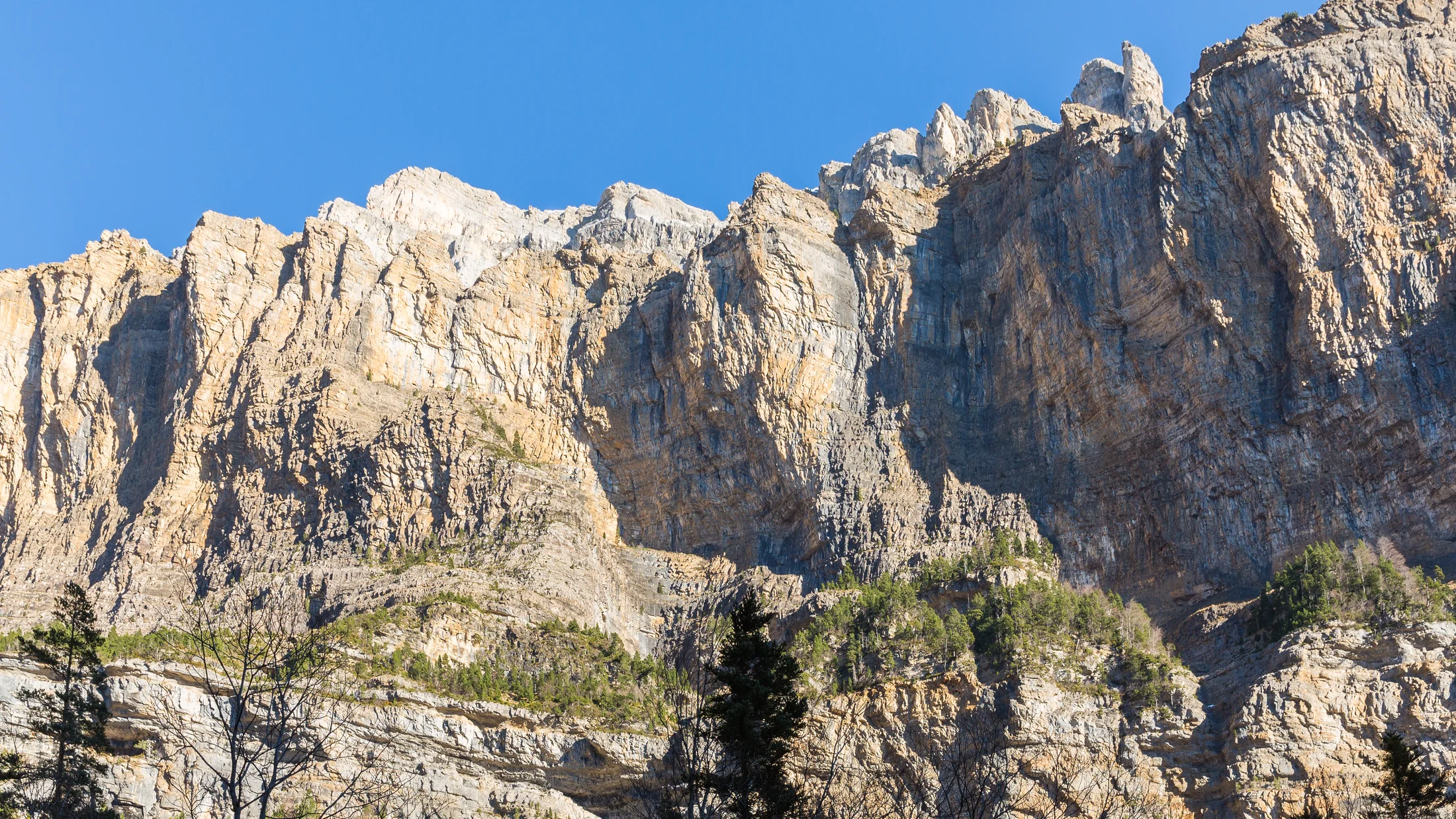
Ordesa and Monte Perdido is unique because a single massif shows the full Pyrenean “ladder”: valley floor, forest, hanging terraces, and summits in clean succession. From the Pradera de Ordesa (1,300 m) you see step-like waterfalls, then the Soaso cirque, then Monte Perdido forming the skyline. A faint smell of resin rises from Scots pine while the river Ara runs clear and cold. Long-term protection controls access in peak months, limits camping, and prioritizes conservation of flagship species like the lammergeier and capercaillie. This layered landscape makes it ideal for varied routes: family-friendly paths in the valley, mid-level balcony trails (fajas), and the classic ascent to Monte Perdido from the Góriz refuge. Expect weather to change fast, especially above 2,000 m, so route choice and timing matter.
What you will learn and key trip facts
You will learn the must-do Ordesa hiking trails, how to reach them, where to stay, when to go, and what to pack. Quick facts help you plan efficiently:
- Location: north Huesca (Aragón), Spain; core coordinates around
42.65°N, 0.03°E - Valleys: Ordesa (Torla), Añisclo (Escuaín/San Úrbez), Valle de Pineta (Bielsa), Bujaruelo (San Nicolás)
- Best time:
- Hiking: late May–October (snow lingers into June on high routes)
- Ascents: July–September for Monte Perdido; earlier/later requires snow gear
- Snow/ice scenes: December–March (road and trail limits apply)
- Climate notes: afternoon storms in summer; ice on ledges in spring/autumn; cooler, wetter than lowlands Use this to pick routes that match your time, fitness, and season.
Picuco te puede ayudar
Does something here catch your eye?
Tell us.
Write to us on WhatsApp or email: we answer questions, find the best options and help you sort out the booking.
Getting There, Parking and Public Transport
Reaching the park is straightforward by car and possible—but limited—by bus. From Zaragoza, take the A-23 to Sabiñánigo and continue on the N-260 to Torla-Ordesa (about 170–200 km; 3–3.5 hours). From Huesca, plan around 105–130 km via A-23/N-260 (2–2.5 hours). From Pamplona, head toward Jaca and then N-260 east (about 160–190 km; 3–3.5 hours). From France’s western side (Biarritz/Bayonne), you cannot drive directly into Bujaruelo via Gavarnie; instead cross via the Portalet (Formigal) or the Bielsa–Aragnouet Tunnel to reach N-260 and the Spanish valleys. The smell of wet stone after a summer squall tells you you’re in the mountains; drive with patience like the locals do.
For the Ordesa valley (Pradera de Ordesa), private cars are normally restricted in high season (Easter, summer, long weekends in autumn). You park at Torla-Ordesa’s large lot and use the official shuttle bus to the Pradera; services typically run every 15–20 minutes in peaks, with first departures early morning and last in late afternoon. Confirm current schedules and any seat reservation requirements on the park’s and Torla municipality’s official channels before you go. If you drive up on a restricted day, you risk a fine and being turned back.
Other access points vary:
- Valle de Pineta: drive to the end of the road at the Parador de Bielsa trailheads; parking is limited on summer weekends.
- Cañón de Añisclo: the road is narrow and may have one-way or time-window regulations in season; check the Provincial Government of Huesca advisories.
- Bujaruelo: a paved then well-maintained track reaches San Nicolás de Bujaruelo and its parking; arrive early in summer to secure a spot.
Public transport is seasonal. Buses connect Zaragoza–Huesca–Sabiñánigo year-round, with limited extensions to Torla-Ordesa and Bielsa depending on the month. Expect reduced or no service to Escuaín and Bujaruelo; taxis operate in the area, and some accommodations can arrange transfers. To travel sustainably, combine mainline trains/buses to Huesca or Sabiñánigo with local services and the Torla shuttle, and avoid peak-hour arrivals if you can.
Where to Stay: Bases That Work for Every Kind of Trip
Base choice shapes your days in the park, from quick access to the Pradera to quiet nights under dark skies. Torla-Ordesa sits at the gate to the main valley with the shuttle at your doorstep, while Broto has more services and the Sorrosal waterfall for an evening stroll. In Bielsa/Pineta you wake to views of a perfect glacial cirque, and Escuaín keeps you close to the wild Cañón de Añisclo. The scent of woodsmoke in village lanes feels timeless after a day on the trail. Use the quick comparison below to pick your base.
| Base town/area | Access focus | Travel time to key trailheads | Who it suits | Pros | Cons |
|---|---|---|---|---|---|
| Torla-Ordesa | Ordesa valley (Pradera shuttle) | 0–10 min to shuttle; 20–30 min to Bujaruelo | First-timers, families, day hikers | Easiest Ordesa logistics; multiple eateries; gear shops | Busy in July–August; parking fills early |
| Broto | Ordesa/Bujaruelo | 10–15 min to Torla; 30–40 min to Bujaruelo | Travelers wanting services + charm | More lodging variety; evening walks to Sorrosal | Slightly longer to shuttles |
| Bielsa / Valle de Pineta | Pineta cirque, higher routes | 30–40 min to Pineta trailheads | Photographers, hikers, ascent planners | Spectacular scenery; quieter nights | Farther from Ordesa/Pradera |
| Escuaín / San Úrbez | Cañón de Añisclo, Escuaín | 15–30 min to Añisclo access | Seekers of solitude | Fewer crowds; dramatic canyon hikes | Sparse services; winding roads |
| San Nicolás de Bujaruelo | Bujaruelo valley | At trailhead | Hikers wanting trail-out-the-door | Immediate access; mountain feel | Limited services; track access |
You will find:
- Rural hotels and guesthouses in Torla/Broto with breakfast and packed-lunch options.
- Campsites around Broto/Torla (seasonal; confirm opening months).
- Mountain refuges like Góriz (for ascents/long traverses) that require advance booking in summer.
- The Parador in Pineta and smaller lodgings in Bielsa for a base deep in the cirque.
Pick by profile:
- Families: Broto or Torla keep logistics smooth and allow half-day waterfall circuits.
- One-day hikers: Torla or a night in San Nicolás de Bujaruelo for early starts.
- Mountaineers: Stage in Torla/Broto, sleep at Góriz for Monte Perdido, or base in Pineta for high cirque routes. Book early for July–September weekends and during Easter; shoulder seasons (May–June, late September–October) reward you with quieter trails and vivid beech forests.
Essential Routes in the Ordesa Valley
1.Cola de Caballo: the classic valley walk to Ordesa’s emblem
If you walk just one trail here, make it the path to the Cola de Caballo waterfall. Starting at the Pradera de Ordesa (1,300 m), follow the wide valley path past Arripas, La Cueva and El Estrecho falls toward the Gradas de Soaso and the cirque, finishing at the famed fan-shaped cascade. Spray hangs in the air like a cool veil on summer afternoons. It’s about 17–18 km round trip, with roughly +500–600 m cumulative gain, and takes 6–7 hours at a steady, family-friendly pace.
Trail character:
- Clear waymarking, good tread; some stony sections and roots.
- Out-and-back route; you can shorten by turning at the Gradas de Soaso if time is tight.
- Best light for photos is early morning at the lower cascades and late afternoon at Soaso.
Tips:
- Start with the first shuttle from Torla to enjoy quieter paths; by mid-morning in summer it gets busy.
- Families with kids: bring snacks, sun protection, and expect many short stops; the Gradas de Soaso (about 2.5–3 hours from the Pradera) make a great picnic target.
- In autumn, beech color is superb from mid-October, but days are shorter and ice can appear in shaded spots; microspikes may be useful late in the season.
2.Senda de los Cazadores: a steep climb to balcony viewpoints
The Senda de los Cazadores is the classic steep ascent to the high rim, linking to the Faja de Pelay with a grandstand view of the entire valley. From the Pradera, the path climbs quickly to the Mirador de Calcilarruego, then rolls along the faja (ledge) before descending near Soaso and returning via the valley path. Your breath mingles with the resin scent as cliffs glow gold above the green floor. Expect about 18–20 km total with +900–1,100 m gain, 7–8 hours for the full loop.
Know before you go:
- The initial climb is sustained and hot in sun; there’s occasional exposure but the tread is good.
- Several natural viewpoints allow breaks; Calcilarruego is the prize for a long pause.
- Recommended season is late spring to autumn; do not attempt when icy or snow-covered.
Alternatives:
- If you prefer less gain, ascend via the Senda de los Cazadores and return early from a mid-point on the faja.
- On very warm days, reverse the loop to descend the Senda de los Cazadores early; many prefer to climb rather than descend steep ground, so choose according to your comfort.
3.Faja de Pelay: a panoramic traverse above the valley
The Faja de Pelay is a high-level traverse with commanding views across to the opposite cliffs and down to the valley floor. Start from the Mirador de Calcilarruego (via Senda de los Cazadores) and contour above the forest to Soaso; close attention is needed where the ledge narrows. The wind smells of crushed thyme as it slips along the sun-warmed rock. The loop via faja and valley takes 6–7 hours; as an out-and-back section, allow 3–4 hours to enjoy the most scenic middle stretch.
Key points:
- Difficulty: moderate to demanding due to exposure in places, length, and heat.
- Not suitable when snow or ice is present; late spring to early autumn is best.
- Start/finish: Pradera de Ordesa; ascend Senda de los Cazadores to reach the faja and descend via Soaso/valley trail.
Safety:
- If you’re uncomfortable with heights, avoid the narrowest sections; turn around well before if needed.
- Helmets are not standard here, but sure-footedness and trekking poles help on uneven ground.
4.A medium loop via the Gradas de Soaso and nearby viewpoints
For a half-day circuit that captures the valley’s essence, combine the lower waterfalls with the Gradas de Soaso and a return on the opposite bank track where allowed. The river narrates your walk with constant white noise and a cool breath on the skin. Plan 12–14 km, +300–400 m, and 3.5–5 hours depending on stops and photo breaks.
Route idea:
- Outbound: Pradera → Arripas → La Cueva → El Estrecho → Gradas de Soaso.
- Return: retrace to a signed bridge crossing and take the more open track to vary scenery and pace.
- Best flow for cascades is late spring to early summer; after heavy rain, expect spray and slick rocks.
Family notes:
- Shorten by making the lower waterfalls your goal (6–8 km, 2–3 hours).
- Keep kids on the path near canyon edges; carry a light extra layer, as shade by the river can feel cool even on warm days.
5.Monte Perdido ascent: the classic high-mountain route
Monte Perdido (3,355 m) is a big objective with alpine hazards that demand planning and good conditions. The standard itinerary goes from the Pradera to the Góriz refuge on day one, then to the summit and back to Góriz or the valley on day two; strong parties may compress it, but it’s not advised for your first time. At dawn, snowfields blush pink while the rock smells faintly metallic under early sun. From the Pradera to Góriz is roughly 10–12 km with +700–800 m (3–4 hours); summit day adds +1,200 m and 6–8 hours, including the notorious slope of La Escupidera near the top.
Requirements:
- Technical difficulty: alpine hiking/scrambling with objective hazards; snow/ice persists into July many years.
- Essential in early season: crampons, ice axe, helmet; rope may be prudent for icy descents.
- Book the Góriz refuge well ahead in summer; check conditions reports locally and from the refuge.
Guiding and norms:
- Hiring a certified guide increases margin for error if you lack alpine experience.
- Bivouac norms and camping limits apply; no fires, drones, or dogs off-leash. Start early, turn back if conditions or timing slip.
6.Short interpretive walks from the Pradera and accessible paths
If you have just a few hours or want a low-effort day, the Pradera de Ordesa offers short, interpretive circuits that reveal forest transitions, river features, and wildlife signs. Leaves flicker silver in a breeze and the cold river air feels like a natural air conditioner. Expect 30–90 minutes for the shortest loops on mostly flat surfaces, some designed to be accessible with strollers or reduced mobility aids.
What to look for:
- Panels explaining beech-to-pine transitions, glacial shaping, and river terraces.
- Birdlife in the canopy, trout in clear pools, and tracks in damp earth near the banks.
- Benches and clearings for quiet breaks; mornings offer the calmest ambience.
Make the most of it:
- Use these walks on travel days or before the shuttle back to Torla.
- Pair an interpretive loop with the lower waterfalls for a gentle half-day that still feels immersive.
Beyond the Main Valley: Añisclo, Pineta and Bujaruelo
Cañón de Añisclo: narrow depths, hanging forests and echoing water
The Cañón de Añisclo is where the Bellos River cuts a deep limestone gash lined with hanging woods and niches. Trails from the Hermitage of San Úrbez loop through bridges and galleries while higher paths from Escuaín look down into the abyss from lofty balconies. The air smells damp and mineral here, and the river’s roar bounces between walls. Typical outings range from 2–4 hours for the San Úrbez loop (easy-moderate) to longer PR/GR paths along the canyon edges (moderate-demanding; exposure in places).
Plan for:
- Narrow, sometimes slippery tread; roots and rock steps are common.
- Seasonal one-way traffic or access regulations on the canyon road; check current rules before committing.
- Safer water levels in late spring to early autumn outside immediate post-storm periods; avoid channels and banks during or after heavy rain.
Link with Ordesa:
- Use Añisclo for a second or third day when Ordesa is crowded; start early to park.
- Combine with an afternoon in Escuaín’s small hamlets and viewpoints, where bearded vultures often patrol the thermals.
Valle de Pineta: a perfect cirque with options for every pace
The Valle de Pineta opens dramatically at its cirque head, where the Cinca River tumbles from hanging cliffs. Easy riverside strolls start near the Parador de Bielsa, while the demanding climb to the Balcón de Pineta and the Lago de Marboré promises jaw-dropping views beneath Monte Perdido’s north face. Pine resin scents the air and cool spray from the Cinca touches your cheeks on breezy days. Choose from 1–2 hour family walks to waterfalls (easy) or a 7–9 hour ascent to the Balcón (+1,200 m, demanding; not for beginners).
What to expect:
- Accessibility: riverside paths are gentle and broad; higher routes are steep, with scree and occasional snowfields into July.
- Crowds: fewer than Ordesa on many days, but summer weekends still fill parking early.
- Landscapes: textbook U-shaped glacial valley, with afternoon light ideal for photographers.
When to prioritize:
- Early summer to see waterfalls in full flow; late summer for safer high routes.
- Autumn for golden larches and calmer weather windows.
Bujaruelo: quieter valleys with classic crossings and green meadows
Bujaruelo offers a gentler pace and a network of routes that feel less busy than Ordesa proper. Begin at San Nicolás de Bujaruelo’s medieval bridge and choose between the Puerto de Bujaruelo (historic crossing to France), the high Ibón de Bernatuara, or easy meadow rambles. The river Ara sounds like steady applause as you walk through grass scented with wild mint. Easy-to-moderate hikes fill half days; the Puerto loop can take 5–6 hours (moderate), while Bernatuara is a 5–7 hour high-mountain lake outing (+900–1,100 m, demanding when snow lingers).
Logistics:
- Access by road/track from Torla; parking is limited in peak season.
- Facilities are fewer than Torla/Broto; plan water and food in advance.
- Bujaruelo can anchor a multi-day plan: one day here, one in Ordesa, and one in Pineta, moving with the weather and crowd patterns.
Waterfalls, Viewpoints and Wildlife to Seek Out
Ordesa and Monte Perdido is a living classroom for water, rock and wing. Beyond the big trails, focus your day on waterfall sequences, balcony viewpoints, and quiet wildlife windows to deepen the experience. Sunlight shards through beech leaves, and the hiss of distant cascades rises and falls with the wind. Structure your time so that light, flow, and silence work in your favor.
Highlights:
- Waterfalls: Arripas, La Cueva, El Estrecho, Gradas de Soaso (Ordesa); Cascada del Cinca (Pineta). Best flows late spring to early summer; watch for slick rocks.
- Viewpoints: Mirador de Calcilarruego (Senda de los Cazadores), Faja de Pelay benches, Balcón de Pineta (demanding access), and Escuaín balconies (canyon scale without the crowds).
- Wildlife: Bearded vulture (Escuaín and Pineta thermals), griffon vulture, golden eagle, chamois on high ledges, marmots above 2,000 m. Dawn and dusk are best; keep distance and use binoculars.
Guided activities:
- Birdwatching walks, geology interpretation, and night-sky sessions operate seasonally with certified local guides.
- Adventure options include via ferrata (in authorized areas), canyoning in permitted ravines, and winter snowshoeing when conditions allow.
- Typical prices vary by activity and group size; confirm current options and availability on Picuco or with certified operators in season.
For families and photographers:
- Families: pick a waterfall circuit in Ordesa or a riverside walk in Pineta; bring a field notebook for kids to log sightings.
- Photographers: target early starts in Ordesa for soft light on cascades; late light at Pineta’s cirque; and the blue hour in Broto by the Sorrosal waterfall.
Gear, Safety, Permits and Practical Faqs
Essential kit by route type
The right kit turns a stunning day into a safe one. Even valley walks here are long by casual standards, so think “light mountain” rather than “city park.” The cool river air may trick you into under-layering in the morning; pack adaptable layers and keep your feet dry.
Day-hike basics (Cola de Caballo, lower waterfalls, Bujaruelo meadows):
- Sturdy hiking shoes/boots with grip, 20–30 L pack
- 1.5–2.5 L water per person; snacks and a proper lunch
- Sun hat, sunglasses, sunscreen; light rain shell
- Map/app with offline topo, power bank, headlamp
- Trekking poles help on long returns and uneven ground
Balcony trails and medium loops (Senda de los Cazadores, Faja de Pelay, Gradas de Soaso circuit):
- As above, plus extra mid-layer and wind layer
- Additional water (2–3 L), blister kit, small first aid
- Poles strongly recommended for steep climbs/descents
High-mountain ascents (Monte Perdido, Balcón de Pineta, Bernatuara when snow lingers):
- Mountaineering boots in early season, helmet, gloves
- Crampons and ice axe when snow/ice persists; practice use beforehand
- 30–35 L pack with survival blanket, warm layers (including insulated jacket), hat
- Early or late shoulder seasons may require microspikes even on balcony paths due to morning ice
Winter/snowshoeing:
- Snowshoes or skis where appropriate, avalanche awareness where relevant
- Extra insulation, waterproof layers, thermos with hot drink
Pack the night before using a checklist, and tailor to route length, weather, and your pace.
Safety, seasonal hazards and difficulty-based tips
Mountain hazards here are manageable with foresight. Weather shifts fast; storms build on summer afternoons, ice lingers on shaded ledges in spring and autumn, and canyon rivers surge after rain. Pine resin scent can vanish in a minute as wind brings a chill: that’s your cue to layer up and reassess.
Core practices:
- Check forecasts from AEMET and look for local updates posted at Torla and trailheads.
- Start early; plan to be descending or on valley floor by mid-afternoon in storm season.
- Avoid balcony trails (fajas) when snow or ice remains; a simple slip has high consequences.
- In the Cañón de Añisclo, keep well above wet undercuts and do not approach the river after heavy rain.
- On Monte Perdido, La Escupidera is a known accident spot; if snow is firm, turn around without proper gear/skills.
Difficulty guidance:
- Easy: valley-floor paths, lower waterfalls, Pineta riverside—long but straightforward; watch fatigue on the return.
- Moderate: Senda de los Cazadores, Faja de Pelay, Bujaruelo Puerto—sustained climbs, some exposure, long duration.
- Demanding: Monte Perdido, Balcón de Pineta, Bernatuara with spring snow—alpine hazards, route-finding, steep snow or scree.
Emergency prep:
- Share your route plan and turnaround times; carry a whistle and headlamp.
- In Spain, dial 112 for emergencies; describe your location precisely (use
GR-11crossing near Góriz, for example, or app coordinates). - If in doubt, hire a certified guide—especially for Monte Perdido early/late season.
Permits, timings, maps and useful apps
Entry to the park is free, but access and overnight rules are strict. Camping is prohibited; limited high-altitude bivouac may be allowed above certain elevations between dusk and dawn—check current park regulations before planning. Drones are not permitted; dogs must be on leash; fires are strictly banned. Shuttle rules apply in Torla–Pradera during peak periods.
Timing your day:
- Use Naismith’s Rule as a baseline (1 hour per 4–5 km plus 1 hour per 600 m ascent), then add 25–40% for photo stops and family pacing.
- Begin early; cola lines form at shuttle stops and trail narrows.
Maps and planning:
- IGN 1:25,000 topo maps cover the park well; the
GR-11traverse passes via Góriz. - Recommended apps: IGN Mapas, Gaia GPS, AllTrails, and AEMET for weather; download offline maps and store a GPX track.
Check the official Parque Nacional de Ordesa y Monte Perdido outlets and the Torla-Ordesa information office for current shuttles, closures, and conditions.
Frequently asked questions
When is the best time to hike to the Cola de Caballo waterfall?
Late May to October offers the most reliable conditions, with peak flow in late spring and early summer. Start on the first shuttle to avoid crowds, and bring a light layer for cool morning air near the river.
Do I need to reserve parking or a shuttle in summer?
For the Ordesa valley, you park in Torla and take the official shuttle on restricted days; seat reservations or caps may apply on peak dates. Always check current details with Torla-Ordesa and the park before arrival to avoid fines or long waits.
Can I climb Monte Perdido without a guide?
Yes, experienced mountaineers often do in summer when snow has receded, but early/late season requires crampons, ice axe, and solid skills. If you lack recent alpine practice or if snow remains, hire a certified guide and book the Góriz refuge in advance.
What should I do if I encounter wildlife on the trail?
Observe from a distance and never feed; use binoculars for close views. If a chamois or vulture is close, stay quiet, give space, and let it pass; report injured animals to the park office rather than intervening directly.
Are there services on the Pradera de Ordesa?
Basic facilities are available seasonally near the Pradera and at Torla-Ordesa, but carry sufficient water and food for the day. Refilling options in the valley are limited; treat water if you must collect from streams.
Is there public transport to Escuaín or Bujaruelo?
Regular buses typically do not reach these trailheads. Plan to drive, use taxis, or arrange a transfer with your accommodation; check seasonal variations before committing to a bus-only plan.
Book your experience — discover outdoor activities in Spain with providers verified by Picuco.
Conclusion
Ordesa and Monte Perdido brings together balcony trails, roaring cascades, and one of the Pyrenees’ most compelling summits in a compact, protected space. If you match routes to your time and season—Cola de Caballo for an all-ages classic, Senda de los Cazadores for sweeping views, Valle de Pineta for cirque drama, and Bujaruelo for quiet meadows—you’ll see why generations return. Pack smart, start early, and follow Leave No Trace principles so the next hiker hears the same river song you did. Plan your dates, book your base in Torla, Broto, or Pineta, and set out with respect for weather, wildlife, and the communities that keep these mountains alive.