Why Asturias’ Wild Beaches Win Over Crowded Resorts
You come to Asturias for coastlines that still feel like coastlines. Beyond the boardwalks and umbrellas, wild beaches in Asturias hide under cliffs, unroll between river mouths, and sit steps from whitewashed fishing villages. Within the first bend of the road near Cudillero, Playa del Silencio tells you the truth: jagged headlands, shingle whispering under swell, and a silence you carry home. The air smells of salt and wet fern.
Here you find a practical guide for curious travelers: you will get a clear overview of where these beaches lie, how to read tides, when to go, how to reach them by car, train, or on foot, and where to sleep near harbors and rural campsites. We highlight 12 essential sands and coves—Torimbia and Gulpiyuri in Llanes, the famed Playa del Silencio near Cudillero, Barayo’s protected dunes between Valdés and Navia, and other hidden beaches in Asturias, Spain—so you can plan routes that link villages and viewpoints at your own pace. We include approximate coordinates, access notes, parking tips, best times of day, and safety for swimming, surf, and photography.
Asturias favors travelers who enjoy simple plans: couples chasing sunsets over cliff beaches in Asturias, families who like wading in calm tidal pools, and hikers or photographers who rise for first light. These shores can be raw and changeable, so we flag real-world cautions—loose steps, swell rebounding off rocks, steep paths that become slick after rain, and coves that vanish at high tide. The sea here is the Cantabrian, powerful and quick to change; if you are unsure, don’t push it.
Use this article to decide what fits: quiet sands at dawn, surfable beach-breaks when the period is right, or coastal rambling that strings coves together along the GR-E9/Senda Costera. You will also find how to check tides (Puertos del Estado), weather (AEMET), and maps (IGN/Iberpix or Google Maps). When you arrive, slow down, greet the neighbors, and remember that these paths and dunes survive because local communities still fish, farm, and maintain them. Your choices—where to park, how to move, what to carry out—help keep these places wild for the next visitor.
Picuco te puede ayudar
Does something here catch your eye?
Tell us.
Write to us on WhatsApp or email: we answer questions, find the best options and help you sort out the booking.
Where These Beaches Are And How To Read The Map
Asturias’ coastline stretches roughly 345 km from the Eo estuary on the Galician border to the Deva river shared with Cantabria. The A-8 motorway runs parallel to most of it, while older N-632 and N-634 roads thread through villages. East to west, cliffs grow and fall, dunes appear, and small river mouths carve havens that often shelter the area’s best beaches. On clear days, the Cantabrian glints steel-blue below limestone ridges while the Picos de Europa hover inland like a weather signal.
Think of the coast in three practical arcs:
- Eastern arc (Ribadedeva–Llanes–Ribadesella): Calcareous cliffs, blowholes, arches, and photogenic coves. Many of Asturias’ best beaches cluster here: Torimbia, Gulpiyuri, Cuevas del Mar, Ballota, Andrín, Toró, and Poo.
- Central arc (Villaviciosa–Gijón–Avilés–Cudillero): Larger bays and river mouths, accessible sands like Aguilar near Muros de Nalón, and iconic cliffs like Playa del Silencio in Cudillero’s orbit.
- Western arc (Valdés–Navia–Coaña–Tapia): Long, open beaches and dune systems under steady Atlantic energy, including Barayo and Frexulfe, backed by meadows and low headlands.
You can plan effective day-loops by matching villages to coves and a tide window. Use official mapping from the Instituto Geográfico Nacional (IGN) on the Iberpix viewer for contours and paths, Google Maps for driving and estimated times, and local panels posted on-site for updated access rules. The GR-E9 (Senda Costera del Cantábrico) and local PR trails stitch together many approaches; short spurs drop from clifftop miradores to sand.
To help you anchor routes, these coastal towns serve as strong bases and checkpoints:
| Town/area | Why it helps | Nearby wild sands |
|---|---|---|
| Llanes | Dense cluster of coves, services, railway stop | Torimbia, Gulpiyuri, Ballota, Andrín, Toró, Poo, Cuevas del Mar |
| Ribadesella | Central for east–central mixing, river estuary | Cuevas del Mar (short drive), eastern cliffs |
| Cudillero | Cliff amphitheater, access to viewpoints | Playa del Silencio, Gueirúa, Aguilar (nearby in Muros de Nalón) |
| Navia–Valdés | Western dunes and long open beaches | Barayo, Frexulfe |
| Muros de Nalón–San Esteban | Easy access, coastal promenade | Aguilar |
- Driving times on the A-8 are short: Oviedo to Cudillero ~45–55 min; Oviedo to Llanes ~1 h 15–30 min; Gijón to Llanes ~1 h 10–20 min.
- The
N-632andN-634often deliver prettier views but slower progress; allow extra time for farm traffic and pullouts. - Narrow-gauge trains (Renfe–FEVE) follow the coast and stop in many villages; they suit flexible plans and light gear, not tight timetables or pre-dawn shoots.
For a two- or three-day plan, anchor one night in Llanes (eastern cluster) and one in Cudillero or Muros de Nalón (central cliffs), then add a western night near Navia or Luarca for dunes and open horizons. You can then link 3–5 beaches per day by pairing tide-dependent spots with vantage points that work at any hour.
A final mapping tip: cliff-backed coves can look close on a screen yet require descents that feel alpine in damp weather. Always cross-check satellite view against contours on IGN/Iberpix. If a path looks faint on aerial imagery, expect rough footing and bring time in hand.
When To Go, Tides, And Sea Conditions
Asturias’ best months for a relaxed wild-beach tour run May–October, with a sweet spot in June and September for lighter crowds. Summer air temperatures hover roughly 20–26°C; water averages around 18–20°C in August and dips to 13–15°C in spring, per long-term Cantabrian records. Mornings often start calm; sea breezes freshen afternoons, and fronts can roll through quickly. The sea smells clean and cool before a front pushes in.
Tides shape these coves. The Cantabrian has a semi-diurnal tide (two highs, two lows daily) with ranges commonly 2–4 m on spring tides. At low tide, pools appear at Cuevas del Mar and Gueirúa, and broad footprints of sand open at Torimbia, Ballota, and Frexulfe. At high tide, Gulpiyuri may hold only a shallow lagoon, Poo becomes a calm inlet, and some shingle strips nearly vanish. Check Puertos del Estado for tide tables (choose the nearest reference port, often Gijón/Avilés), and add 30–45 minutes of buffer at remote coves to avoid being cut off.
Use AEMET’s coastal forecast for swell height, period, and wind, and layer in a surf model or Windy-type app for a second opinion. As a rule of thumb:
- Swell <1 m: many coves feel placid; tidal pools clear; photography is straightforward.
- Swell 1–2 m: long beaches like Frexulfe break nicely; cliff coves may surge against rock walls.
- Swell >2 m or long periods (>12 s): avoid narrow coves and slippery boulder fields; waves can surge past normal lines.
If you plan surf, target open beaches facing northwest–north with room to spread sandbars. If you plan swimming, prefer lifeguarded sands in high season (Aguilar, occasionally Toró and others) or choose protected inlets at mid-tide with clear escape lines. For children, shallow estuarine coves like Poo at mid-tide work well, while blowhole areas and jagged reefs do not.
A simple pre-departure check reduces surprises:
- Confirm high/low tide times and range for your chosen beach.
- Read AEMET coastal forecast and note swell height, period, and wind.
- Pick a Plan B nearby that suits the opposite tide or stronger swell.
Safety first
- Wet rock turns into black ice; wear treaded shoes.
- Never nap under cliffs; rockfall happens without warning.
- Respect seasonal closures in dune and nesting areas; fines apply and the harm is lasting.
Getting There And Where To Stay Near The Sea
Most visitors arrive by car via the A-8 Autovía del Cantábrico and exit onto short spurs to the coast. Parking varies from small cliff-top pockets to organized lots signed in summer; on fair weekends, spots near Torimbia, Cuevas del Mar, and Poo fill before noon. In peak season, local councils sometimes restrict last-mile car access at the busiest coves to prevent erosion and chaos; if a barrier closes the road, park in the designated lot and walk.
Public transport works well for base-to-base moves and some beach hops:
- Narrow-gauge coastal trains (Renfe–FEVE) link many towns between Gijón and Llanes/Santander; expect scenic, not speedy.
- Regional buses connect Oviedo, Gijón, Avilés, Ribadesella, Cudillero, Navia, and Llanes; frequencies rise in summer.
- Taxis handle early shoots, late returns, or one-way hikes.
Final access often involves short tracks:
- Coastal footpaths: the
GR-E9/Senda Costera traverses long sections and intersects multiple coves and miradores. - Local
PRroutes: well-marked, short trails to dunes or cliff-top lookouts. - Farm lanes: respect gates, crops, and signed restrictions; never block field access.
Where to sleep depends on your rhythm:
- Fishing villages and small ports: Cudillero, Llanes, Ribadesella, Luarca, Navia, Muros de Nalón. You’ll find inns, apartments, and guesthouses within walking distance of tapas bars and early-morning bakeries.
- Rural stays: Casas rurales and agritourism homes sit a few minutes inland, quieter at night and good for families.
- Campings: Coastal and riverside campgrounds offer tent pitches and bungalows; some sit near beaches like Poo, Cuevas del Mar, or along the western dunes.
Practical booking notes:
- July–mid-September books out weeks ahead near headline beaches; reserve early or aim for midweek.
- For sunrise/sunset photography, choose lodging within a 10–20 minute drive of your top targets.
- If you rely on public transport, anchor in towns with both train and bus stops (Llanes, Ribadesella) and select beaches on those corridors.
Choose stays that match your route: Llanes for the eastern cluster, Cudillero or Muros de Nalón for Silencio/Aguilar, and Navia–Valdés for dunes and open horizons. You’ll shorten transfers and keep your days in the salt and light instead of traffic.
Twelve Wild Beaches You Shouldn’t Miss
1) Playa de Torimbia: long arc under limestone cliffs (llanes)
Torimbia is a classic of the best beaches in Asturias, a sweeping crescent under grassy cliffs near Niembro. Access begins at the Torimbia viewpoint and continues on a well-trodden path descending to broad pale sand backed by smooth headlands. At low tide, the beach expands and rock tongues appear near the edges; at high tide, the arc stays generous for walking and sunset watching. Evening light folds gold over the sea like warm silk.
- Location: Llanes municipality, near Niembro; approx
43.4405, -4.8520. - Access: Park near the mirador in designated zones (summer restrictions may apply) and walk 10–15 minutes down.
- Notes: Traditional nudist use coexists with general beachgoers; respect everyone’s comfort and space.
- Best time: Late afternoon to sunset for soft light; mid-to-low tide reveals more sand.
- Safety: Moderate shorebreak on swell; keep distance from cliff base due to occasional rockfall.
- Nearby services: Bars and shops in Niembro and Llanes; no on-beach facilities.
Why go: For sweeping views and that wild-beach-in-Asturias feeling framed by cliffs—textbook playas con acantilados Asturias.
2) Gulpiyuri: the landlocked sea cove (llanes)
Gulpiyuri is an inland beach connected to the sea via underground karst tunnels, a geological curiosity that is cenit-friendly for photos. A flat field path leads from parking areas near Naves to a tiny sinkhole bay where waves seep or pulse in depending on tide. At high tide on calm days, a knee-deep lagoon forms; at low tide on small swell, water can retreat and leave a sandy bowl. The sound here feels like a seashell pressed to your ear.
- Location: Llanes municipality, near Naves; approx
43.4357, -4.9638. - Access: Short walk (5–10 minutes) on signed paths; parking in marked areas only.
- Fragility: It’s a protected spot; treat it as one of the playas vírgenes Asturias deserves—stay off the fragile edges.
- Best time: Mid-to-high tide on small swell days to see water in the bowl; early morning to avoid crowds.
- Safety: Not suited for real swimming; the basin is small and can surge; keep children within arm’s reach.
- Nearby services: Naves and Nueva de Llanes; no services at the cove.
Why go: To witness a unique karst beach and to practice low-impact visiting at a delicate natural site.
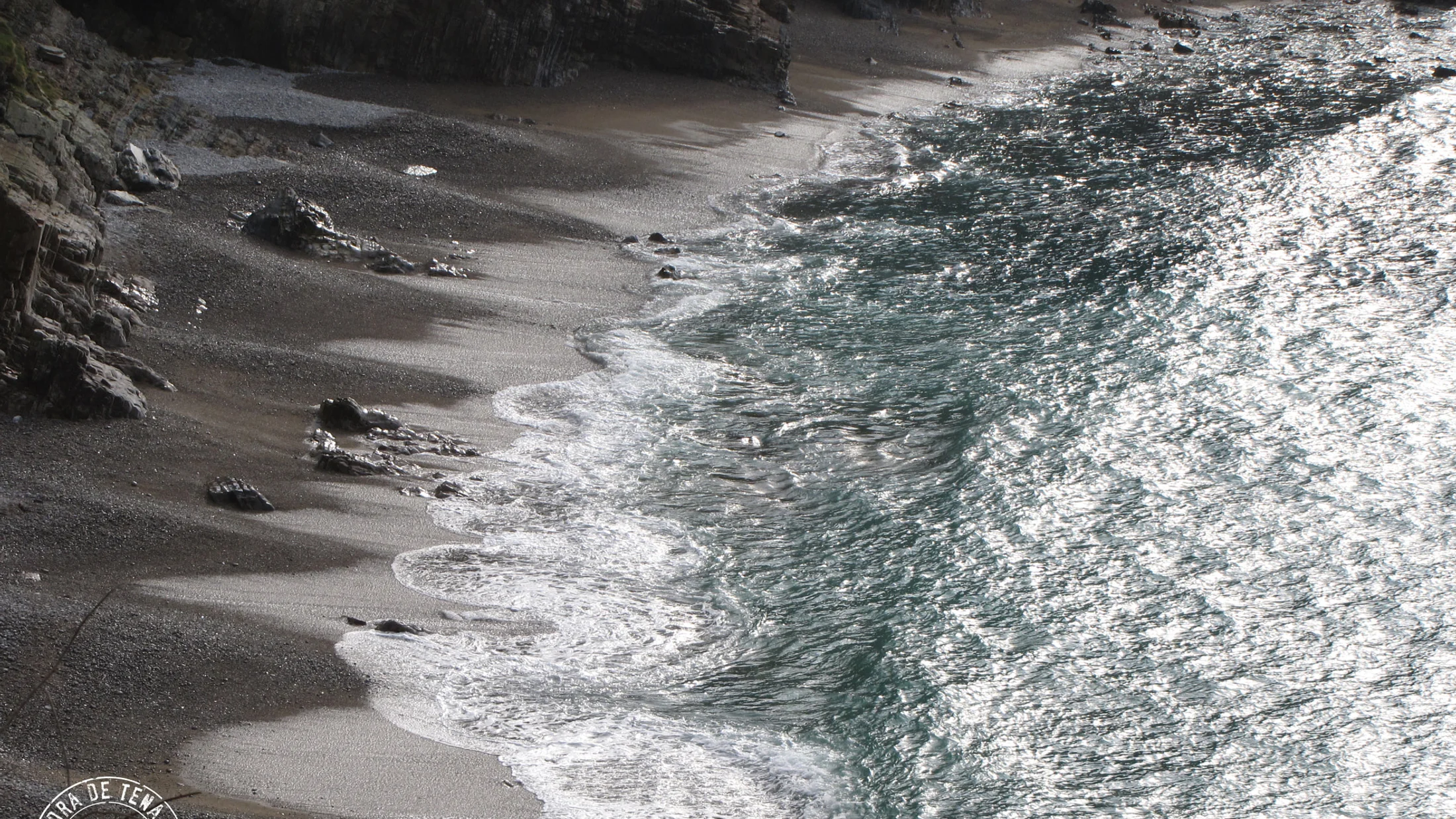
3) Playa del Silencio: cliffs and hush of the sea (cudillero)
Playa del Silencio lives up to its name, a scallop of polished shingle and rock spires under tall cliffs west of Cudillero. A signed lane leads to the cliff-top viewpoint; from there, steps descend to the cove, where the sea wraps sound in a soft roar that earns the beach its fame. Sunset paints the headlands bronze while gulls stitch slow arcs across the water.
- Location: Cudillero municipality, near Castañeras; approx
43.5713, -6.2583. - Access: Small car parks along the access road; expect a 10–15 minute descent by steps and path.
- Best time: Golden hour to sunset; morning works for calmer water and fewer people.
- Safety: No lifeguards; swell can rebound off the cliff; rocks are slick—good footwear essential.
- Photography: Compose from the mirador at wide angle; at low tide, foreground boulders frame the bay.
- Nearby services: Cudillero and nearby hamlets; none at the beach.
Why go: Because the primary keyword becomes a place—Playa del Silencio is the poster child for wild beaches in Asturias.
4) Playa de Barayo: river, marsh, and dunes (valdés/navia)
Barayo is a Partial Nature Reserve where a short river meanders through reeds to meet the sea across a wide dune system. Trails from both sides (Valdés and Navia) converge near the back-beach; wooden walkways and signs keep feet off the most sensitive dune crests. On quiet mornings, reeds hiss in the breeze and waders stalk the shallows like careful pens.
- Location: Between Valdés and Navia; access points near Sabugo (Valdés) and Vigo/Barayo side; approx
43.5595, -6.6340. - Access: Marked reserve trails; allow 15–25 minutes on foot; parking in designated lots only.
- Protection: Respect closures; no dune trampling; check seasonal wildlife notices.
- Best time: Mid-to-low tide to appreciate the full beach width; spring and autumn for birdlife and quieter scenes.
- Safety: Open beach with notable shorebreak on swell; swim only in calm conditions.
- Nearby services: Villages inland; none on the sand, by design.
Why go: For a textbook playas vírgenes Asturias experience that balances raw Atlantic with living dunes.
5) Playa de Gueirúa: rock spires and tide pools (cudillero)
Gueirúa is a photographer’s gem: tilted rock strata, narrow channels, and low-tide pools that catch sky light. The descent from Santa Marina is steep and can be muddy; allow time and bring proper shoes. At low tide, pools form like polished mirrors between ribs of stone, while at high tide, swell surges and erases footholds. The shore sounds like a thousand pebbles rolling in a slow exhale.
- Location: Cudillero municipality, near Santa Marina; approx
43.5635, -6.2473. - Access: Small parking near the cemetery; 15–25 minute steep path to the cove.
- Best time: Mid-to-low tide for pools and safe footing; dawn for calm wind and pastel color.
- Safety: Slippery rocks, no lifeguard; avoid during strong swell or rain-slick days.
- Activities: Landscape and long-exposure photography; tidepool macro; careful exploring only.
- Nearby services: Limited; Cudillero holds dining and lodging.
Why go: To feel a genuinely wild pocket of coast that rewards patience and precise timing.
6) Playa de Ballota: viewpoints and the Castro islet (llanes)
Ballota sits under green cliffs opposite the Castro islet, a perfect anchor for compositions from several roadside miradores. Access is straightforward by local lane and a short path to fine sand; at lower tides, rock shelves at the ends produce small pools and patterns. Waves crease around the islet while swifts flicker across the cliff face.
- Location: Llanes municipality, near Andrín/Ballota area; approx
43.4283, -4.8044. - Access: Signed parking areas; short walk down; miradores directly along the lane.
- Best time: Sunrise for even light on the beach; late afternoon for backlight silhouettes of the islet.
- Safety: Respect currents near rock walls; avoid climbing unstable slopes.
- Photography: Classic telephoto compression from the upper bends; mid-tide for texture.
- Nearby services: Llanes and Andrín.
Why go: For easy access to one of the best cliff-beach scenes in Asturias with multiple vantage points.
7) Playa de Cuevas del Mar: caves, arches, and sheltered sand (llanes)
Cuevas del Mar curls into a compact bay guarded by natural arches and perforated limestone walls, a playground for eyes and careful feet. A short, paved approach from the village of Nueva makes this one of the more accessible wild-feeling coves, especially at low tide when little pools and cave mouths reveal themselves. On calm days, water sits teal and glassy like a held breath.
- Location: Llanes municipality, near Nueva; approx
43.4427, -4.9722. - Access: Road to beachside parking; short walk; summer fills early.
- Best time: Mid-to-low tide to see arches and walk the sand safely.
- With kids: Good option on small swell; explore the back of the bay and shallow pools; avoid cave interiors with rising tide.
- Safety: Beware slippery rock and surges through gaps on swell days.
- Nearby services: Bars and shops in Nueva; seasonal services near the beach.
Why go: For geology up close and a family-friendly window into cliff beaches in Asturias.
8) Playa de Aguilar: wide, accessible, and still partly wild (muros de Nalón)
Aguilar spreads a generous beach under soft headlands, with parking, lifeguards in season, and cafés nearby. Even with amenities, the far ends hold a touch of wildness, especially early or on overcast days when crowds thin. The air carries coffee and sea spray from the promenade.
- Location: Muros de Nalón; approx
43.5544, -6.1206. - Access: Paved road to large car park; coastal path links to viewpoints toward San Esteban.
- Best time: Morning for space and calmer wind; low-to-mid tide for more walking room.
- Safety: Usually one of the safer swims when guarded, but shorebreak strengthens on big days.
- Services: Seasonal lifeguards, showers, cafés, and WC; great fallback when remote coves feel risky.
Why go: For a comfortable base-beach that still hints at the wild, ideal when you want facilities without losing scenery.
9) Playa de Frexulfe: dunes and an open horizon (navia)
Frexulfe (also Frejulfe) runs long and straight with a dune backline and river mouth, classic of the western arc. Several signed approaches lead to parking behind dunes and short boardwalks to sand; wind sculpts ripples and grass whispers along the crest. When swell lines march in, the whole beach feels alive with movement and sound.
- Location: Navia municipality; approx
43.5672, -6.7071. - Access: Marked parking near the back-dune; short sandy approaches.
- Best time: Mid-to-low tide for space and cleaner breaks; shoulder seasons for solitude.
- Safety: Stronger shorebreak and currents on bigger days; swim cautiously or not at all without guards.
- Activities: Surf on medium swell; long beach walks; dune and bird observation from designated paths.
- Nearby services: Navia and nearby villages; limited at the beach.
Why go: For a sense of scale and freedom typical of playas vírgenes Asturias on the west coast.
10) Playa de Andrín: quiet cove with a scenic approach (llanes)
Andrín sits in a gentle bay flanked by cliffs and low, grassed slopes, reached by a small local road and short path from the village. The beach has a calm demeanor on small swell and feels tucked away even when nearby spots fill. Waves lace the shore with thin white lines that vanish as fast as they arrive.
- Location: Llanes municipality, near Andrín; approx
43.4135, -4.7429. - Access: Road to a small car park; steps down to sand; also reachable via coastal paths.
- Best time: Morning for soft light; mid-tide balances sand area and access to edges.
- Safety: Watch for reflected waves near the cliffs; keep clear under unstable sections after rain.
- Combine with: Short strolls through Andrín village and a stop at the Ballota viewpoints.
- Services: Limited at the beach; more in Llanes.
Why go: For a quieter complement to Ballota with a village feel and easy logistics.
11) Playa de Toró: rocky pocket with coastal views (llanes)
Toró lies beside Llanes town, a pocket beach studded with sharp limestone pinnacles that turn the shoreline into a sculpture garden. A promenade skirts the back-beach and links to coastal walks that step out toward other coves. At low tide, rock textures pop; at high tide, swell braids around the stacks with a hiss.
- Location: Llanes municipality, next to town; approx
43.4237, -4.7574. - Access: Easy from town by foot or short drive; parking nearby.
- Best time: Low tide for patterns and safe rock hopping; golden hour for warm light.
- Safety: Rocks are slick; wear shoes; avoid swimming in strong swell.
- Services: Seasonal lifeguards some summers; cafés and WC near the promenade.
- Hiking: Link with town coastal paths toward Poo or westward viewpoints.
Why go: For a photogenic, accessible taste of wild geology without leaving the orbit of a fishing town.
12) Playa de Poo: small inlet beside a village port (llanes)
Poo is a narrow estuarine cove that fills gently with the tide, a family favorite beside the village and small harbor area. At mid-tide on calm days, shallow channels make wading and kid-friendly exploring easy; at low tide, sandbanks and puddles keep curious feet busy. The cove hums with quiet chatter and the soft plash of paddles.
- Location: Llanes municipality, Poo de Llanes; approx
43.4276, -4.7816. - Access: Short drive from Llanes; signed parking; 5-minute walk.
- Best time: Mid-tide on small swell; avoid peak midday in high season.
- Safety: Generally mild inlets when calm; still watch the tide, which can rise quickly.
- Services: Seasonal lifeguards some years; small bars and rentals in season.
- Combine with: Walks to Toró or the town of Llanes for an easy beaches-and-villages day.
Why go: For a gentle stop on a beaches-and-coastal-villages Asturias route, especially with children.
What To Do: Surf, Swim, Hike, And Photograph
These wild beaches in Asturias lend themselves to simple, satisfying days when you match conditions to the right spot. On open-swell days, western sands like Frexulfe and sections near Tapia draw surfers; on medium days, Torimbia and some central beaches break rideable lines. Look for local surf schools operating seasonally at accessible sands, and confirm availability and skill level on Picuco before you go. Sea breeze carries a sniff of kelp that signals changing wind.
Swimming works best on smaller swell and in coves with lifeguards in season, such as Aguilar or sometimes Toró and Poo. Without supervision, treat the Cantabrian conservatively: check entry and exit points, avoid cliff corners where waves rebound, and swim parallel to shore rather than straight out.
Hiking the coast ties these experiences together. Sections of the GR-E9/Senda Costera link Llanes’ tight cluster of coves, while central and western paths connect dunes, river mouths, and viewpoints. Keep stages short to allow lingering at a cove that suddenly turns perfect with the tide.
Landscape photography rewards early starts and flexible framing. At Silencio and Gueirúa, low tide unlocks foreground structure; at Ballota and Torimbia, golden hour paints cliff grass and sea surface; at Cuevas del Mar, side-light reveals textures in arch walls. Bring a light tripod, polarizer, and microspikes or good soles for wet rock; always prioritize footing over the shot.
Pair activity with community: stroll a market in Llanes, have a café con leche above Cudillero’s harbor, and thank the people who maintain footpaths and signage. This coast remains wild because it is also lived-in.
Practical Tips: Tides, Parking, Services, And Respect
A few habits make wild-beach days smoother and gentler on the places you love:
- Reading tides:
- Use Puertos del Estado for high/low times and ranges; choose a nearby reference port.
- Add buffer: arrive 45 minutes before low if you need pools; leave 45 minutes before high if exit is narrow.
- Parking without stress:
- Follow summer restrictions; when barriers close final lanes, park in signed lots and walk.
- Never block farm access or park on dry grass during fire risk periods.
- Services and isolation:
- Aguilar, Toró, and sometimes Poo offer lifeguards/amenities in season; expect none at Silencio, Barayo, or Gueirúa.
- Carry water, a small first-aid kit, and a light layer; weather turns quickly.
- Pets and camping:
- Rules vary; many beaches restrict dogs in summer day-hours—check local council boards.
- Wild camping is generally not allowed; use official campgrounds.
- Leave No Trace basics:
- Pack out all waste; stay on marked paths; avoid dune crests and signed sensitive areas.
- Keep music off; let wind and waves be the soundtrack.
- Safety with swell and cliffs:
- Do not sit under overhangs; rockfall is silent until it isn’t.
- If in doubt, don’t enter the water; enjoy the walk and the view.
These small choices protect playas vírgenes Asturias and make every visit calmer and better for everyone.
Frequently Asked Questions
When is the best time to visit Asturias’ wild beaches?
June and September balance pleasant air (around 20–26°C), warmer water, and lighter crowds. May and October can be excellent with more variability. Summer weekends get busy near Llanes; go early or late.
Are all these beaches safe for swimming?
No. Many coves have no lifeguards and can see strong shorebreak or rebounding waves on swell. Choose guarded sands (e.g., Aguilar in season) or very calm days; enter where you can also exit easily.
How do I check tides for specific coves?
Use Puertos del Estado to get daily high/low times and ranges for the nearest port, then adapt by 15–45 minutes based on your location and approach time. Plan low tide for pools (Cuevas del Mar, Gueirúa) and broader sand (Torimbia, Frexulfe).
Can I visit without a car?
Yes, but plan carefully. Coastal trains and regional buses reach Llanes, Ribadesella, Cudillero, and Navia. From there, walk the GR-E9 to cluster beaches or use taxis for early/late connections.
Where should I base myself for a long weekend?
Split nights: Llanes for the eastern cluster (Torimbia, Gulpiyuri, Ballota, Andrín, Toró, Poo, Cuevas del Mar), then Cudillero or Muros de Nalón for Silencio and Aguilar. Add Navia/Valdés for Barayo and Frexulfe if you have a third night.
Can I bring my dog?
Regulations vary by council and season. Many beaches restrict dogs during summer daytime hours; shoulder seasons are more flexible. Check on-site signage before committing to a descent.
Book your experience — discover active travel in Spain with verified providers on Picuco.
Conclusion
Asturias rewards those who chase edges: cliff-backed arcs that glow at sunset, dunes that give way underfoot, and coves that appear only when the tide allows. You now know where these beaches lie, how to time them, and how to reach them—by road, rail, and footpath—and you’ve seen 12 standout options from the hush of Playa del Silencio to Barayo’s living dunes and Llanes’ sculpted shores. The smell of salt and fern lingers when you plan with space and patience.
Map your days around tide windows, pick bases that shorten dawn and dusk drives, and balance remote coves with lifeguarded sands when you want a calmer swim. If this coastline speaks to you, sketch a route, reserve a bed in a fishing town or a rural camping cabin, and set the alarm for first light. Share your respect with the land and the people who care for it: tread lightly, greet kindly, and leave each place better than you found it.