Vertigo With Views: Step Onto Spain’s Hanging Walkways
You step onto steel and wood with air yawning below, and Spain’s canyons open like a book of stone. If hanging walkways Spain has been on your mind, this guide is for you: hikers curious about exposure, photographers chasing clean light, and travelers who feel vertigo yet want to face it with care. From the celebrated Caminito del Rey to the sculpted ledges of the Ruta del Cares and the sheer walls of Mont‑rebei, these aerial trails deliver height, geology, and history in one focused experience.
We set out clear, practical information: where they are, when to go, how to get there, and where to stay, with a quick‑facts section on 12 standout routes and alternatives to dodge crowds. The goal is simple—help you decide which walkways match your comfort, fitness, and time, then plan safely and support local communities along the way. Sun glints off the river like a blade as a vulture tilts overhead. You’ll find distances, estimated timings, exposure levels, reservation policies, and seasonal notes so you can pick a day with the right light and the right wind. Read on to choose one unforgettable balcony above water and stone.
Picuco te puede ayudar
Does something here catch your eye?
Tell us.
Write to us on WhatsApp or email: we answer questions, find the best options and help you sort out the booking.
Why These Aerial Paths Are Worth Your Time
These routes give you a unique blend of exposure, access, and story that a typical footpath rarely matches. Hanging walkways concentrate drama—minutes of cliffside stride where geology and engineering meet—so you enjoy adrenaline in a controlled setting, with railings, anchors, and regular maintenance. The boards hum softly underfoot as water loops through polished bends below. They also open windows onto fragile habitats: the Gaitanes Gorge’s ibex and raptors at Caminito del Rey, or the Noguera Ribagorçana’s cliff ecosystems in Mont‑rebei, where sheer limestone rises hundreds of meters.
Beyond thrill, there’s heritage. Many aerial trails follow routes cut by hydroelectric projects, shepherds, or early explorers; Caminito del Rey traces a century‑old service path, while the Ruta del Cares was hewn to maintain a canal. These places anchor local identity as much as they draw visitors. The wind carries a resin tang from pines as a bell tolls from a village far below. For photographers, expect towering frames at golden hour, long‑lens vulture portraits, and milky green rivers mid‑day; for families, some sections offer short, secure stints near parking; for ambitious hikers, longer traverses add distance to the drama.
Economically, canyon catwalks Spain support rural economies when done right—off‑season stays, guide services, and meals in small towns make a difference. They differ from simple hiking routes in three ways: engineered safety that enables non‑climbers to brush true exposure; compact access to cliff and river scenery; and interpretive value that reveals geology, waterworks, and traditional uses of the land. The rock face radiates stored warmth as your hand grazes a cable smooth with years of passage. Ultimately, these walks deliver a clean sense of achievement: you read the forecast, chose a time, moved past the flutter in your stomach, and earned a panorama you’ll remember.
Essential Information for Planning
Good planning turns a striking path into a relaxed day out. The following notes cover location patterns, seasons, transport, and stays near the walkways, with resources for maps and local rules. Sweet thyme drifts from cracks in sun‑warmed limestone as swallows stitch arcs across the gorge. Use these basics to time your visit for calm weather, soft light, and easier logistics.
Locations and maps
You’ll find most major pasarelas grouped by region: Andalucía (Caminito del Rey near Málaga; Los Cahorros in Granada), Aragón (Alquézar over the Río Vero; Parrizal de Beceite in Teruel; Añisclo in Huesca), Aragón/Catalonia (Mont‑rebei and the Montfalcó side stairs on the Huesca/Lleida border), Galicia (Ribeira Sacra with the Cañón del Sil and the wooden Mao river walkways), and Cantabria/Castilla y León (La Hermida and the nearby Ruta del Cares between Poncebos, Asturias, and Caín, León). If you search “pasarelas vértigo España,” these clusters appear quickly on official tourism maps and hiking apps.
- Typical road distances to trailheads: Málaga to Caminito del Rey 60–65 km; Huesca to Alquézar 50–55 km; Aínsa to Añisclo 35–40 km; Granada to Monachil 8–12 km; Lugo/Ourense to Sil viewpoints 55–90 km; Lleida to Mont‑rebei (La Masieta) about 75–90 km.
- Map tools that work: Spain’s IGN viewer for contours, Google Maps for access roads and parking, and hiking apps with
GPXtracks for path detail. - Park authorities and councils often publish simple schematic maps; check them the day before for any diversions.
The river riffles like torn silk under oak shade while you trace line and contour on your phone.
Best seasons and weather
Aim for spring and autumn across most sites: stable temperatures, clearer air, and kinder sun angles for photos. Summer can bring heat in Andalucía and Aragón; winter adds ice risk above 1,200 m in the Pyrenees and shaded canyons. Light scrapes gold across the walls during the first and last hours of day. Early starts beat crowds at Caminito del Rey and Mont‑rebei, and late afternoons can be quiet at Los Cahorros outside weekends.
- Watch forecasts from AEMET (Spain’s meteorological service) for wind warnings; elevated gusts can close exposed catwalks.
- Avoid heavy rain days in narrow canyons; water levels rise quickly, and wooden walkways get slick.
- In high country (Añisclo vicinity), freeze‑thaw can leave black ice in shadow even on sunny days.
The gorge breathes cool as shaded drip lines bead into tiny chandeliers along the rock.
Getting there (car and public transport)
A car remains the most flexible option for dispersed sites: paved access to major trailheads, plus short sections of good gravel to secondary parking. Shuttle services operate where routes are linear or parking is restricted—Caminito del Rey runs a paid shuttle between exits and entries, and in peak season certain valleys add extra buses or regulate access roads. The shuttle rumbles softly as the canyon quiet returns after each departure.
- Rail/bus nodes: Málaga–Álora/El Chorro for Caminito; Granada–Monachil buses for Los Cahorros; Lleida/Barcelona to Balaguer/Tremp then taxi for Mont‑rebei; Huesca to Barbastro/Alquézar by bus; Posada de Valdeón/Cangas de Onís for Cares approaches; Ourense/Lugo for Ribeira Sacra boats and viewpoints.
- Rentals: book compact cars early for weekends; mountain road clearances are normal but expect bends and occasional narrow tunnels.
- Sustainable options: pair train/bus with local taxis or pre‑booked shuttles; consider midweek trips to reduce pressure on small car parks.
Check official site notices or local tourist offices the week of your trip for updated shuttle times.
Stays and local services
Base yourself in villages near each canyon: casas rurales and small hotels put you minutes from trailheads and early light. Reserve well ahead for spring and autumn weekends, and consider Sunday–Tuesday nights for quieter stays. Woodsmoke and fresh bread scents sift through cobbled lanes at dawn. Look for:
- Lodging: rural houses, hostels, campgrounds near rivers (often with shade and swimming), and small hotels in historic centers.
- Food: menus del día in village bars, bakeries for trail snacks, and regional specialties—trout, game stews, olive oil pastries.
- Services: gear shops, certified guides for exposed traverses, seasonal kayak/boat operators in gorges such as the Sil or Mont‑rebei.
Booking midweek supports local rhythms and spreads benefits; travel light, buy local, and ask about trail conditions at the bar—someone likely walked it yesterday.
The 12 Walkways and Aerial Canyon Trails: Quick Facts
Below you’ll find uniform “cards” to compare difficulty, timings, height, and any reservations or fees. We keep each entry concise and practical so you can choose fast. A kestrel hangs motionless over the updraft as your boot touches the first plank.
1.Caminito del Rey: historic walkway over the Gaitanes Gorge
- Location: El Chorro/Álora, Málaga; Desfiladero de los Gaitanes Natural Area.
- Difficulty: easy to moderate; exposure managed by wide boards and railings.
- Aerial section length: about 2.9 km of walkways; total route 7.7–8.0 km one‑way.
- Max height above river: roughly 100–105 m.
- Time needed: 2.5–3 hours including shuttles.
- Requirements: advance reservation required with timed entry; helmets provided; closures possible for high wind or heavy rain; daily capacity limited.
- Accessibility: not suitable for strollers or wheelchairs; steady footing needed; children allowed with age limits (check official site).
- What makes it unique: a century‑old service path reborn—Caminito del Rey marries engineering and drama in an accessible package near Málaga.
The gorge narrows to a slot where turquoise churns, and the walkway clings like a ribbon to orange limestone. To avoid crowds, book the earliest slot, carry water (no refill points on the boards), and plan your shuttle before entering.
2.Pasarelas de Alquézar: steel and wood above the Río Vero
- Location: Alquézar, Huesca; Sierra y Cañones de Guara Natural Park.
- Difficulty: easy to moderate; short-stepped sections with railings.
- Aerial section length: roughly 1.0–1.5 km of catwalks within a 2.5–3.0 km loop.
- Max height above river: 15–30 m depending on water level and segment.
- Time needed: 1.5–2 hours.
- Requirements: controlled access with small fee; closures after floods; check municipal notices.
- Accessibility: not wheelchair accessible; suitable for cautious beginners who want brief exposure.
- What makes it unique: pasarelas Alquézar thread sculpted conglomerate canyons and reveal rock art country and karst springs near a beautiful medieval town.
Water purls under the boards as dragonflies flicker blue over still pools. Start from the village and follow the signed circuit; in summer, early mornings avoid heat and swimmers at the pools—keep to designated spots and mind variable flow after storms.
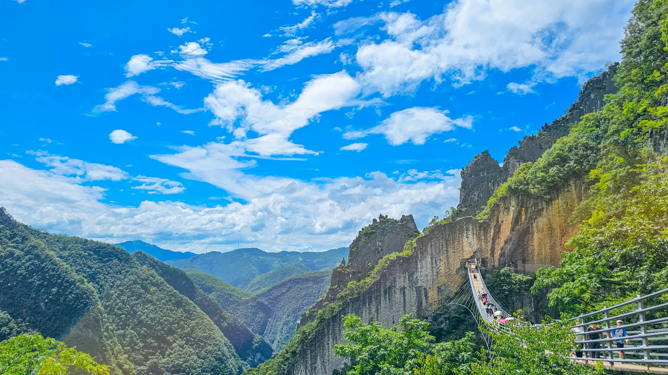
3.Mont‑rebei (congost de Mont‑rebei): ledges carved into sheer walls
- Location: Border of Lleida (Catalonia) and Huesca (Aragón), along the Noguera Ribagorçana within the Serra del Montsec.
- Difficulty: moderate due to exposure; path is wide enough but unprotected in places.
- Aerial section length: 2–3 km of carved ledges and cliffside trail.
- Max height above river: the canyon walls exceed 500 m; path sits high above water for extended stretches.
- Time needed: 3–5 hours out‑and‑back from La Masieta (Catalonia side) or longer if combining with Montfalcó stairs (Aragón side).
- Requirements: no hiking permit; boats/kayaks on the reservoir require reservations with certified operators; hot, dry days demand extra water.
- Accessibility: not suitable for small children or severe acrophobia; head for stable weather and low wind.
- What makes it unique: a sinuous corridor of sky and stone where the path itself becomes the viewfinder’s frame.
The river gleams a glassy green slab under vertical limestone streaked with ochre. Access via La Masieta (Catalonia) or Montfalcó trailhead (Aragón); if combining both sides, plan a car shuttle or boat return and carry a headlamp for tunnels if extending.
4.Ruta del Cares: the classic cliff path of Picos de Europa
- Location: Poncebos (Asturias) to Caín (León), Picos de Europa National Park.
- Difficulty: moderate for distance and exposure; good footing essential.
- Aerial section length: multiple kilometers of cut ledges and galleries.
- Max height above river: hundreds of meters above the Río Cares in places.
- Time needed: 6–8 hours roundtrip (24 km) or 3–4 hours one‑way with arranged return.
- Requirements: no permit; summer heat and crowding; occasional shuttle/taxi services operate in peak periods on each side—confirm locally.
- Accessibility: not for vertigo sufferers; families with older, sure‑footed teens do well; avoid in ice.
- What makes it unique: Ruta del Cares pairs relentless canyon drama with the living story of water channels cut for hydro projects a century ago.
White water whispers far below while goats startle pebbles from the edge into silence. Start early from either end, pack layers for tunnels and shade, and consider a one‑way with taxi return to keep the day under five hours.
5.Cañón del Sil (ribeira Sacra): viewpoints and stepped paths above the Sil
- Location: Ourense/Lugo (Galicia), Ribeira Sacra; includes wooden walkways on the Río Mao and high miradores over the Sil canyon.
- Difficulty: easy to moderate; boardwalks and stepped paths with railings; some steep ascents to viewpoints.
- Aerial section length: wooden Mao walkways ~1.5–1.8 km; viewpoint approaches vary.
- Max height above river: viewpoints rise 300–400 m above the Sil; walkways over the Mao sit tens of meters above the stream.
- Time needed: 2–4 hours combining a boardwalk loop and two or three miradores; boat rides 60–90 minutes.
- Requirements: boat seats require reservation; autumn weekends are busy; fog possible in mornings.
- Accessibility: selected viewpoints near road lay‑bys; boardwalks involve stairs.
- What makes it unique: pasarelas Ribeira Sacra weave forested ravines while vineyards cling to slopes and the Sil runs polished and dark through the rock trench.
A grape scent rides the air where terraces catch the last light above slate and water. Pair a Mao boardwalk stroll with miradores like Cabezoás or As Penas de Matacás, then a catamaran ride to see basalt dikes and vineyard lines from below.
6.Parrizal de Beceite: clear pools and ledges on the Matarraña
- Location: Beceite, Teruel; Ports de Beseit/Matarraña region.
- Difficulty: easy to moderate; wooden walkways, stepping stones, short bridges.
- Aerial section length: 600–800 m of walkways within a 7–8 km return route.
- Max height above river: generally 5–15 m; exposure is low and family‑friendly.
- Time needed: 2.5–3.5 hours return, more with swim stops.
- Requirements: controlled summer/holiday access with paid parking and quotas; closures after heavy rain.
- Accessibility: not wheelchair accessible; good for families who can navigate steps and stones.
- What makes it unique: crystal‑clear pools under pale limestone narrows where light bounces green into the canyon’s throat.
Willow shade dapples emerald water as trout suspend like commas in the flow. Book parking in peak months, wear water shoes if you plan a dip in signed areas, and respect the restricted upper narrows to protect habitat.
7.Los Cahorros de Monachil: hanging bridges and sculpted narrows near Granada
- Location: Monachil, Granada; Sierra Nevada foothills.
- Difficulty: easy to moderate; hanging bridges, narrow ledges with chains, simple scrambles.
- Aerial section length: several bridges and cliffside traverses within an 8–9 km circuit.
- Max height above river: 10–25 m on bridges; higher above side ravines.
- Time needed: 3–4 hours for the classic loop.
- Requirements: no permit; weekends and holidays are busy; heat in summer.
- Accessibility: not wheelchair accessible; fine for attentive families; dogs on leash.
- What makes it unique: a lively mix—rope bridges sway over water, basalt‑dark walls pinch you to side‑steps, and river pools cool hot days.
The long main bridge hums under footfalls as the river twirls into froth below. Start early to cross bridges with fewer people, carry a small pack to squeeze through narrow sections, and wear sticky‑soled shoes for occasional polished rock.
8.Desfiladero de La Hermida: balconies and carved paths in Cantabria
- Location: La Hermida, Cantabria; gorge of the Río Deva between Panes and Potes.
- Difficulty: moderate; mix of balcony viewpoints, short walkways, and cliff paths such as the Urdón–Tresviso route (
PR‑S 3). - Aerial section length: varied; from brief rail‑protected viewpoints to many exposed kilometers on the Tresviso path.
- Max height above river: hundreds of meters on the Tresviso traverse; tens of meters at viewpoints.
- Time needed: 1–2 hours for short balcony outings; 4–6 hours for Urdón–Tresviso one‑way with steep gain.
- Requirements: no permit; summer heat in the gorge; occasional winter ice on shaded ledges.
- Accessibility: roadside miradores for quick looks; serious exposure on
PR‑S 3—fit, sure‑footed hikers only. - What makes it unique: a deep limestone trench lined with chestnuts and beech, flanked by villages like Potes and the Fuente Dé cable car a valley away.
Beech leaves clap softly in a breeze while the Deva threads silver through the bottomlands. Combine a short balcony walk or partial Urdón climb with a visit to Potes; in hot weather, plan shade‑biased hours and carry extra water for the steep.
9.Nacimiento del Río Mundo: boardwalks and terraces to the source
- Location: Riópar, Albacete; Calar del Mundo y de la Sima Natural Park.
- Difficulty: easy on official paths; steps to viewpoints.
- Aerial section length: short protective walkways and platforms.
- Max height above river: tens of meters near the amphitheater walls around the spring.
- Time needed: 1–2 hours for official viewpoints; longer hikes possible on adjacent trails.
- Requirements: regulated parking and timed access on busy days; “reventón” water surges after heavy rain draw big crowds.
- Accessibility: family‑friendly; paths and terraces protect fragile moss and tufa.
- What makes it unique: a booming karst spring that suddenly overflows into fans of whitewater, with safe terraces to watch without trampling the source.
Mist cools your face as the waterfall’s roar fills the natural amphitheater. Go early on “reventón” days, heed barriers, and use marked platforms only—this is a living spring system.
10.Cañón de Añisclo: airy balconies in Ordesa’s wild arm
- Location: Añisclo, Huesca; Ordesa y Monte Perdido National Park.
- Difficulty: moderate; cliff‑edge views from signed trails; longer valley hikes can be strenuous.
- Aerial section length: balcony‑style overlooks and exposed bends rather than continuous catwalks.
- Max height above river: several hundred meters above the Bellós River in sections.
- Time needed: 2–6 hours depending on viewpoint loops or valley routes (e.g., San Úrbez–La Ripareta).
- Requirements: seasonal traffic regulations; snow/ice possible in winter; park rules strictly enforced.
- Accessibility: viewpoints near the San Úrbez area; longer trails for experienced hikers.
- What makes it unique: Ordesa’s lesser‑traveled canyon—water, forest, and pale limestone plates lifting to serrated ridgelines.
Cold air spills from the canyon like water poured from a jug, even on warm afternoons. Start from the San Úrbez bridge for a taste of exposure without committing to a full‑day traverse; verify road traffic direction rules before driving in season.
11.Hoces del Río Duratón: rim paths and vulture lookouts in Segovia
- Location: Sepúlveda area, Segovia; Natural Park of Hoces del Río Duratón.
- Difficulty: easy to moderate; cliff‑edge rim paths, broad tracks to viewpoints.
- Aerial section length: no continuous catwalks; multiple airy viewpoints and rim traverses.
- Max height above river: up to 100–150 m above the Duratón’s meanders.
- Time needed: 2–5 hours depending on chosen loop; kayak trips 2–3 hours in season.
- Requirements: nesting season restrictions protect vultures; adhere to signed closures; boat/kayak reservations required.
- Accessibility: many miradores near roads; family‑friendly rim sections with supervision.
- What makes it unique: a green river snaking through cream‑colored cliffs while griffon vultures wheel under your eyeline.
Warm wind smells of thyme as your shadow slides across the wheat stubble near a hermitage. Even without pure “walkways,” the feel is the same—height over water with protective rails at key points; check seasonal wildlife rules before you go.
12.Quieter alternatives: less‑known catwalks to sidestep crowds
- Montfalcó stairs and catwalks (Huesca): linked to Mont‑rebei but quieter on weekdays—spectacular wooden stairs bolted to raw limestone above Canelles; no permit; 3–5 hours return.
- Relleu walkways (Alicante): modern catwalk over the Amadorio gorge; booking system manages capacity; family‑friendly exposure with steel mesh underfoot.
- Cañón de los Hocinos (Burgos): short wooden walkways over the Trueba; low exposure, birdlife, and riparian forest.
- Río Vero aside routes (Guara): smaller local pasarelas upstream/downstream from Alquézar; check councils for status after heavy rains.
- Río Martín canyons (Teruel): stretches with rails and short walkways near Alcaine/Obón combine geology and rock art.
A jay flashes cobalt through poplars as creek light flickers on undersides of leaves. Before you go, ask at local tourist offices for current conditions and any post‑storm repairs; midweek mornings give you space to breathe on these quieter lines.
Recommended Itineraries and Smart Combos
Short on time or combining regions? Here are clear, efficient plans you can adapt to fitness and focus. Dust rises like flour in a sunbeam when a car pulls into the tiny trailhead lot. Choose a base, pick one or two highlights, and add a village with good food so the day ends warm and easy.
-
Weekend escape, Málaga and Caminito del Rey:
- Day 1: Arrive Málaga; drive 60–65 km to El Chorro (1–1.5 hours). Stay in Álora/Ardales. Sunset scouting at reservoirs near El Chorro.
- Day 2: Early Caminito entry (book first slot). Shuttle arranged in advance. Lunch in Álora; optional short hike to Mirador de las Buitreras. For families, limit to walkway and reservoir picnic.
-
Three‑day Aragón duo: Alquézar + Beceite
- Day 1: Huesca to Alquézar (50–55 km). Afternoon pasarelas Alquézar loop; sleep in Alquézar.
- Day 2: Drive 160–180 km to Beceite (2.5–3 hours). Parrizal morning swim stops; siesta; evening stroll in Valderrobres. Sleep in Beceite/Valderrobres.
- Day 3: Short Matarraña village loop; return drive.
-
Four‑day cliff classics: Mont‑rebei + Ruta del Cares
- Day 1: Base in Tremp/Balaguer; half‑day at Mont‑rebei from La Masieta. Sleep near Tremp.
- Day 2: Transfer 5–6 hours to Picos base (Arenas de Cabrales or Posada de Valdeón). Early dinner.
- Day 3: Ruta del Cares one‑way (arrange taxi/shuttle back). Light dinner and recovery.
- Day 4: Optional Fuente Dé cable car for high panoramas; head out.
-
Galicia rim and river: Ribeira Sacra weekend
- Day 1: Boardwalks on the Río Mao + two Sil viewpoints. Sleep in Parada de Sil/Monforte de Lemos.
- Day 2: Morning catamaran; winery lunch; short monastery visit (Santo Estevo).
For photographers, prioritize sunrise/sunset at rim lookouts and midday for walkways shaded in narrow canyons; bring a 24–70 mm and a 70–200 mm. Families should pick routes with limited exposure (Beceite, Alquézar boardwalk segments, selected Duratón viewpoints). Strong hikers can chain long traverses (Cares, Montfalcó + Mont‑rebei linkup) but must plan shuttles, water, and margins for heat. The sky goes pink over a quiet plaza as plates of grilled vegetables arrive—end the day in the village that keeps these paths alive.
Nearby Activities and Places to See
These canyons come wrapped in more than rock: villages, monasteries, swimming holes, and river trips that round out a weekend. Pine pitch scents the air where a chapel perches above the gorge. Fold in one or two of these and your trip feels whole.
-
Viewpoints and easy bonuses:
- Caminito del Rey: Mirador de la Escalera Árabe and reservoir overlooks for sunset.
- Duratón: Ermita de San Frutos rim lookouts with vulture flybys.
- Ribeira Sacra: Balcones de Madrid, Cabezoás, and As Penas de Matacás.
- La Hermida: Santa Catalina balcony near Peñarrubia for a sweeping Deva view.
-
Water, boats, and kayaks:
- Mont‑rebei/Canelles: kayak rentals and boat shuttles (reserve with certified operators in season).
- Ribeira Sacra: catamaran tours on the Sil and Miño show terraces from water level.
- Duratón: guided kayak trips beneath cliffs; strict wildlife rules apply.
-
Villages with character and good food:
- Alquézar’s stone lanes and viewpoints; Beceite and Valderrobres in Matarraña; Potes and Mogrovejo in Liébana; Sepúlveda near the Duratón; Tremp/Balaguer for Mont‑rebei access.
-
Culture and landscape:
- Monasteries of Santo Estevo and Santa Cristina (Ribeira Sacra), rock art centers in Guara, and hydroelectric heritage panels along the Cares.
Bring binoculars for raptors—griffon and Egyptian vultures, occasional lammergeier in the Pyrenees—and a polarizer for water glare. On hot afternoons, signed swimming spots near Beceite or Monachil deliver cool relief; always use designated areas to avoid erosion. Evening walks through small towns mean contact with the people who maintain trails and share current conditions—an honest chat often adds more value than a dozen blog posts. The last swallows trace loops under a bell tower as the canyon shifts to deep blue.
Safety and Essential Gear
Aerial trails reward calm, deliberate movement and clear limits. Step lightly, leave space, and keep eyes on the path when exposure pinches. Warm rock radiates through your soles while a shadowed draft cools your neck. Basic rules protect everyone:
- Do not run or lean over rails; respect one‑way systems and instructions from staff.
- Yield on narrow boards; pass only at widened bays.
- Keep children within arm’s reach; hold hands across bridges.
- If vertigo rises, look to the horizon, breathe slowly, and take micro‑breaks; turn back if anxiety climbs.
Pack for shade, wind, and sudden showers:
- Footwear: grippy trail shoes or light boots; avoid slick soles.
- Layers: light wind shell and compact waterproof; sun hat; light gloves in shoulder seasons.
- Hydration and food: 1.5–2.5 L per person depending on heat; salty snacks.
- Navigation and light: offline maps or
GPXtrack; small headlamp if tunnels or late returns are possible. - Comms and docs: charged phone, ID, insurance details, and small cash for shuttles/parking.
Assess difficulty honestly: short boardwalks like Alquézar and Beceite suit cautious beginners; Mont‑rebei ledges and the Ruta del Cares require comfort with exposure and endurance. In winter and shoulder seasons, expect ice in shadowed bends; in summer, avoid midday heat in southern canyons. If unsure, hire a local, certified guide—technique and pacing lessons on one airy traverse can transform your confidence. The river’s cool breath tells you where shade lingers long after the sun moves on.
Practical Tips: Reservations, Accessibility, Pets, Weather
Avoid friction by booking early where quotas apply and reading local rules before you lace up. The click of an opening gate echoes across calm water at first light. Key points:
- Reservations and tickets: Caminito del Rey requires dated, timed tickets; Ribeira Sacra boats and Relleu walkways use booking systems; certain car parks (Beceite, Río Mundo on peak days) control entry. Book 2–4 weeks ahead for weekends and holidays.
- Cancellations and weather: operators may reschedule or refund when high winds/rain close catwalks—check each site’s policy.
- Accessibility: some rim lookouts (Duratón, Ribeira Sacra) lie near roads; most walkways include steps and narrow sections; contact local offices for up‑to‑date barrier‑free segments.
- Pets: many sites require leashes; some prohibit dogs on narrow catwalks—confirm locally to avoid being turned back at the gate.
- Low‑impact habits: stick to boards and marked paths; do not swim or picnic on fragile ledges; pack out all waste.
Check authoritative sources the day before: AEMET for wind and thunderstorms; local park or municipal pages for closures, shuttle times, and nesting restrictions. If storms build, descend to safe ground away from metal railings and isolated trees, and avoid canyon bottoms that can flash flood. A fine grit taste rides the air as the wind freshens—nature often signals change before your app does.
Frequently Asked Questions
Are these walkways safe if I have vertigo?
Vertigo is a specific balance disorder; many people actually feel acrophobia—fear of heights—which you can often manage with pacing and technique. Start with low‑exposure options like Beceite’s boardwalks, short sections of pasarelas Alquézar, or roadside rim viewpoints in Duratón. Keep your gaze on the horizon, not the drop; walk smoothly, breathe deep, and pause at wider bays. A cool rock face against your palm steadies more than you expect. If your fear escalates or you feel dizzy, turn back without hesitation—there’s no badge for pushing past your limit. Avoid high‑gust days; wind amplifies anxiety. For a step‑up progression, try Montfalcó’s stairs on a calm morning before attempting Mont‑rebei ledges or the long exposure of the Ruta del Cares. When in doubt, go with a certified guide who can coach line choice and movement.
Do I need to book in advance and is there a cost?
Several flagship sites require reservations or manage capacity with fees. Caminito del Rey uses dated, timed tickets and a paid shuttle between access points; book 2–4 weeks ahead for weekends, longer in holidays. Relleu’s catwalks and Ribeira Sacra boat trips also run booking systems; small municipal fees may apply to Alquézar’s pasarelas and Beceite parking in peak season. The turnstile click means your hour has come, and you step into sunlit stone. Many rim trails and viewpoints (Duratón, Añisclo miradores) remain free but can carry seasonal restrictions to protect wildlife. Always confirm prices and policies on official pages, and consider shoulder‑season dates for easier availability. If weather closes a site, most operators offer rebooking or refunds per their terms—read them when you buy.
What fitness level do I need and how do I choose the right route?
Match duration and exposure to your current comfort. Beginners or families should pick short, protected segments with easy bail‑outs: Beceite’s walkways (2.5–3.5 hours return) or Alquézar’s loop (1.5–2 hours). Intermediate hikers can add length and mild exposure—Los Cahorros (3–4 hours) or Ribeira Sacra combos. Strong, sure‑footed hikers who handle heights can tackle Mont‑rebei ledges (3–5 hours) or the Ruta del Cares (6–8 hours roundtrip). The sun warms your shoulders as cool air flows from the shaded throat of a gorge. Read route profiles, note total ascent, and plan water for heat. If an itinerary strings two airy sections, include a rest hour between them; fatigue magnifies fear. Finally, set a turnaround time—when it hits, you turn, regardless of how close the end seems.
What should I do if the weather changes during my visit?
If rain starts, slow down—wooden boards and polished limestone get slick; if thunder approaches, leave exposed ridges, metal railings, and canyon bottoms. Find shelter in solid buildings, vehicles, or dense forest away from single tall trees and avoid gullies that can flash flood. The air turns metallic and still just before a storm breaks. For strong winds, avoid bridges and narrow catwalks where gusts push you; some sites will close—obey staff. Keep emergency numbers for the region saved, and tell someone your plan before you go. Many ticketed sites offer rebooking/refunds if they close for weather; take photos of your tickets and read terms beforehand. Check AEMET and park notices early the morning of your hike and again at the trailhead—microclimates in canyons can differ from nearby towns.
Book your experience — discover vetted outdoor activities across Spain with trusted providers on Picuco.
Conclusion
Hanging walkways Spain are a vivid way to touch height without technical climbing—compact, well‑built windows onto geology, water, and the communities that care for them. You now know where the main clusters are, when to go for better light and fewer crowds, how to move between car, shuttle, and trail, and which routes match different comfort levels with exposure. A thin river thread glows like wire in evening light as the canyon cools around you. We’ve shared quick facts for 12 aerial paths—from Caminito del Rey and Mont‑rebei to the family‑friendly steps of Beceite—plus itinerary ideas, nearby villages and viewpoints, and clear safety habits.
Choose one that fits your day and your nerves, reserve where needed, and pack simple gear for shade, wind, and water. Travel at your own pace, support local lodgings and guides, and treat each railing and board with respect so others can pass in safety. When you step off the last plank and hear the soft noise of the river again, you’ll carry that lightness with you—proof that a measured challenge can open wide, lasting views.