Why Nacedero Del Urederra Captivates
A spring of turquoise light and quiet forest
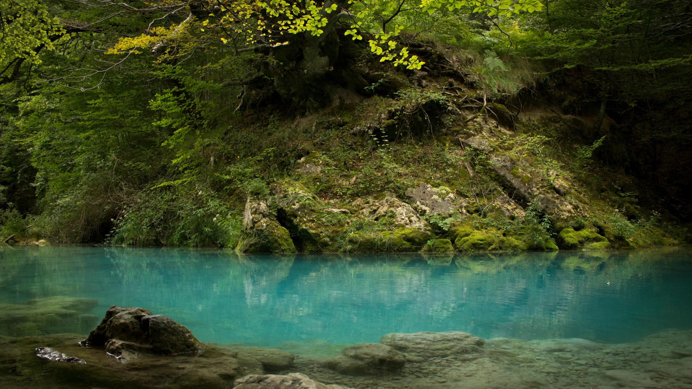
Come for the color; stay for the calm. The Nacedero del Urederra, the karst spring that gives birth to the Urederra River, tumbles from the limestone cliffs of Urbasa-Andia into a chain of turquoise pools and delicate falls. You’re in Améscoa Baja (Navarre, Spain), at the foot of the Urbasa plateau, where rain and snowmelt vanish into porous rock, travel underground, and surge out again as mineral-rich water that shifts from milky blue to bright emerald. One look at the water under beech shade explains the Basque name: Urederra means “beautiful water.”
The reserve protects an intimate river corridor, alive with mosses, ferns, and old beech and maple. Sound softens here; cascades murmur and leaves hush the path. Beyond beauty, this is a living classroom in karst hydrology—karst means a landscape of soluble rock, mostly limestone, carved by water into caves and springs—supporting birds like the short-toed treecreeper and raptors that ride thermals along the cliffs above. For visitors, the promise is simple: a safe, signed path to rare colors, within a protected space where your respect keeps the place wild.
What follows helps you enjoy the turquoise waterfalls Urederra is known for while minimizing impact and maximizing your time. In this guide you’ll find how to get to Urederra, what Urederra permits and Urederra reservations really mean, where Baquedano parking fits in, and a clear Urbasa Andia hike plan you can follow at your own pace. A single morning can be enough; a slow afternoon can be unforgettable.
What you’ll find here and how to use it
Start with Essential information if you need the basics—location, hours, daily capacity, and accessibility. Jump to Getting there for driving directions, Baquedano parking details, and public transport options. If you’re planning dates, read Permits and reservations to understand quotas and how to book. For the experience itself, see Highlights and the 6 km itinerary, with family cut-downs and advanced extensions. The final section packs gear tips, safety notes, photography basics, and a focused FAQ. Read it all to plan a seamless visit; skim the sections you need to secure permits, arrive on time, and leave the reserve as you found it.
A faint scent of damp beech and cold limestone will guide you from the very first bend. Keep this page handy while you plan and check official updates the week you travel.
Picuco te puede ayudar
Does something here catch your eye?
Tell us.
Write to us on WhatsApp or email: we answer questions, find the best options and help you sort out the booking.
Essential Information: Location, Hours, and Capacity
Begin with the map in your head. The Nacedero del Urederra lies in Améscoa Baja (Navarre), with the signed access starting in the village of Baquedano. The approximate trailhead and controlled access are near 42.85°N, -2.13°W. You are 23 km northwest of Estella-Lizarra, roughly 58 km west of Pamplona, and about 55 km south of Vitoria-Gasteiz. The route hugs the northern foot of the Urbasa-Andia escarpment, where the river emerges from the cliff base and winds through a narrow, forested ravine.
- Province: Navarre (Navarra), Spain
- Municipality: Améscoa Baja (access via Baquedano)
- Natural area: Urbasa-Andia Natural Park (protected area)
Think of access control as a conservation tool, not a hurdle. The reserve operates with a daily visitor quota to reduce erosion and keep the water clear. On busy weekends and holidays, staff regulate entry at the Baquedano checkpoint. Entry typically follows daylight hours, with seasonal adjustments and occasional closures for storms, snow, or high winds. Because times can change year to year, confirm the current access window on the Government of Navarre’s official pages (search “Nacedero del Urederra acceso Navarra.es”).
In practical terms, most visits last 2.5–3.5 hours, including an easy picnic and photo stops; very quick visits can be done in 2 hours, but the path rewards a slower pace. The route is signposted and well-trodden, but it’s still forest path: expect roots, stone steps, narrow sections, and occasional mud after rain. Strollers work for the first forest track section only; the full route isn’t wheelchair-accessible due to uneven terrain and short steeper pitches.
Arriving in Baquedano, you’ll find a staffed control point on busy days and printed information boards that explain rules, geology, and route options. Estella-Lizarra’s tourism office offers broader regional information, including Urbasa-Andia maps and current advice on closures or restrictions. In peak season, local volunteers and park staff help manage flows—remember you are visiting a living community that shoulders the responsibility of caring for this place.
Lodging is easiest if you base yourself within 30–40 minutes of Baquedano. Estella-Lizarra has a wide range of small hotels and apartments and acts as a transport hub. Rural houses dot the Améscoa valley, offering dawn starts and quiet evenings under the plateau cliffs. If you plan to visit several natural sites in Navarre, Pamplona or Vitoria-Gasteiz work well as urban bases with day trips.
One sensory note captures the mood: sunlight filtering through beech leaves turns the path a muted green. Use this section to anchor your plan—where you are, when to go, and how long to stay—before diving into logistics.
Getting There: Routes, Baquedano Parking, and Public Transport
Arrive calmly, and the day follows suit. From Estella-Lizarra, take NA-132-A toward Zudaire or link to NA-718 that climbs toward the Urbasa plateau, then follow signs for Baquedano and Nacedero del Urederra. Expect about 25–35 minutes for the 18–23 km, depending on your exact start point and traffic through valley villages. Roads are paved and in good condition, with gentle curves and short climbs. In heavy rain or after frost, drive cautiously: shaded bends can stay slick.
From Pamplona, the typical route goes west via A-10 toward Irurtzun, then south on local connectors to NA-718. Allow 60–75 minutes for roughly 55–60 km. From Vitoria-Gasteiz, head south via A-1 and join regional roads toward the Améscoa valley and Baquedano; plan about 60 minutes for ~55 km. Signage improves as you near Urbasa-Andia; the brown tourist signs for the spring appear before the village.
Use this quick reference as a planning snapshot:
| City (approx.) | Distance | Time | Main roads |
|---|---|---|---|
| Estella-Lizarra | 18–23 km | 25–35 min | NA-132-A, NA-718 |
| Pamplona | 55–60 km | 60–75 min | A-10, local connectors, NA-718 |
| Vitoria-Gasteiz | ~55 km | ~60 min | A-1, regional roads, NA-718 |
The Baquedano parking system is central to a smooth visit. There is controlled, paid parking at the entrance to the reserve, and on peak days staff only allow vehicles with prior reservation. Parking fees and quotas can change seasonally; check the official reservation portal of the Government of Navarre for current prices and availability. Spaces are limited, and the lot fills early on sunny weekends and holidays from spring through autumn.
Key Baquedano parking notes:
- Reserve in advance for weekends, holidays, and peak summer days.
- Print or download your confirmation; mobile coverage can be patchy by the forest.
- Arrive within your booked window; late arrivals may be turned away when capacity is reached.
- Overflow or informal roadside parking isn’t allowed for safety and to protect verges; staff enforce this.
If you arrive without a reservation in peak season, alternatives include:
- Parking legally in other valley villages and hiring a local taxi to Baquedano (book ahead on busy dates).
- Visiting at off-peak hours (first entry of the morning or the last viable entry before closing) if same-day online slots appear.
- Shifting your visit to a weekday when demand drops.
Public transport exists but requires planning. Regular buses connect Pamplona and Vitoria-Gasteiz to Estella-Lizarra. From Estella, services into the Améscoa valley are limited and not timed to trail demand; a taxi for the final 20–25 minutes to Baquedano is the reliable solution. Rail travelers can reach Pamplona or Vitoria-Gasteiz by train, then transfer to bus and taxi. On select dates in peak season, guided outings may run from larger towns; these typically include transport and permits—confirm availability and details well ahead.
When you step out of your vehicle or taxi, listen: the river’s low rush threads through birdsong even before the first bridge. Build extra time into your plan so the drive, parking, and check-in feel like a gentle approach, not a race.
Permits and Reservations: How the System Works and How to Book
Respect begins with planning. Urederra permits and Urederra reservations exist to balance visitor experience with ecosystem health: fewer feet mean clearer water, less trail braiding, and a quieter corridor for wildlife. Quotas apply to daily entries and to Baquedano parking, and on peak days staff check your reservation or permit at the village entrance.
You should book in advance during spring weekends, summer, and peak autumn foliage, and any time a holiday extends the weekend. The reservation portal managed by the Government of Navarre (search “Reserva Nacedero del Urederra Navarra.es”) opens slots on a rolling basis. Policies can change; typical patterns allow you to reserve weeks ahead with a final cut-off shortly before the date. Entry is for personal, non-commercial visits; commercial groups require specific authorization through park management.
Costs and policies at a glance:
- Parking is paid; per-vehicle prices vary by season. Confirm current rates and accepted payment on the official portal before you book.
- Some categories (e.g., residents or certain vehicles) may have adjusted conditions; check the latest notes online.
- The walking permit itself is typically free when you arrive without using the parking, but capacity limits still apply and staff can deny entry when full.
- Cancellation rules are published on the portal; many systems allow refund or date changes within a time window, but do not assume flexibility on same-day changes.
Follow these steps to complete your online reservation with fewer headaches:
- Choose your date and entry window. If you’re flexible, start by checking midweek slots.
- Select your access type: vehicle parking at Baquedano or pedestrian entry if you arrive by taxi/foot.
- Enter the number of people in your party, including children. Many quotas count total heads, not only adults.
- Fill in vehicle details if you book parking; double-check the plate number and car type.
- Review the rules: no swimming, stay on path, pets on lead, and pack out waste.
- Pay if required, and save the confirmation as a PDF on your phone. Take a screenshot as backup.
- The day before, reconfirm weather and any alerts or closures posted by park management.
Useful booking tips:
- If the portal shows no spaces, check again early morning or late evening; cancellations sometimes free slots.
- Book sunrise or late-afternoon entries for softer light and thinner crowds.
- If you stay in the Améscoa valley, ask your host about taxi availability for early entries.
- Bring a photo ID matching the reservation name; staff may request it.
Carry your confirmation, a charged phone, and a simple backup plan (alternate date or different time) so changes in weather or capacity don’t derail your day. As a sensory cue, imagine the cool feel of spray on your forearms at the first cascade—this is what careful planning protects.
Rules of the Reserve and How to Tread Lightly
The rules are simple, and they keep the Urederra blue. Stay on marked paths and behind barriers at viewpoints; stepping off the trail crushes roots, compacts soil, and feeds erosion. Swimming or wading is prohibited throughout the protected corridor; skin oils, sunscreen, and churned sediment can cloud fragile pools. Fires, camping, and cooking are forbidden, and smoking is discouraged or banned depending on risk. Dogs must remain leashed at all times, and noisy behavior is out of place in a narrow, echoing forest.
Drone use is not permitted without explicit authorization from park authorities, for both wildlife safety and visitor privacy. Tripods are allowed where space permits, but keep them inside fenced platforms and off narrow sections. Collecting plants, stones, or deadwood is illegal; leave mushrooms, flowers, and branches where they belong. If you meet wildlife—dippers on midstream rocks, a fox slipping through leaf litter—observe quietly from a distance and give them the right of way.
Behind every rule stands a reason. Karst pools depend on low nutrient loads and undisturbed flow to keep their iconic color. Excess noise displaces sensitive birds that nest along the ravine. Litter, even tiny food scraps, draws animals too close to paths and changes their behavior. Fines apply for infractions, and on busy days rangers and local staff patrol access points and key bends in the trail; treat their presence as guardianship, not policing.
Practice these low-impact habits:
- Pack out everything, including fruit peels and tissues.
- Wear mineral or eco-friendly sunscreen and keep it off the water by not entering streams.
- Step aside on narrow sections to reduce edge trampling; let uphill hikers pass first.
- Photograph from platforms; avoid climbing onto logs or boulders near pool edges.
- Keep group sizes small and voices soft; sound carries under the beech canopy.
If you encounter blocked paths, unstable railings, or fresh erosion, report it at the entrance booth or to the regional park contact listed on the signs. Locals, volunteers, and park staff maintain this trail day after day; a respectful word and a thank-you go a long way. As you walk, notice one clear sensation: cool air rises from the water like a gentle breath, asking you to slow down.
What to See and a 6 Km Route That Covers It All
1) Turquoise falls and pools: where and when they shine
Chase color, not crowds. The cascades turquesa Urederra are brightest when the sky is bright but shaded—think early morning or late afternoon with the sun behind trees. Spring brings fuller flow and deep milk-blue tones; summer narrows streams but clarifies pools to gemstone green; autumn frames everything in copper beech leaves, while winter, on milder days, offers bare-branch light and glassy water.
Best viewpoints are purpose-built platforms along the route and natural bends where the path edges the river behind barriers. Look for stepped falls where thin curtains spill into round basins and for “marmitas”—potholes carved by swirling stones—visible as circular depressions in bedrock. Avoid mid-day high sun in midsummer if you want to reduce glare and harsh contrast; angle yourself to sidelight and use foliage to shade the lens. If you carry a small polarizing filter, rotate it gently to cut reflections without robbing the water of its glow.
Hold one image as you plan: floating beech leaves spin on a turquoise eddy like slow coins. Stay behind rails, keep tripods compact on platforms, and let others step in between frames.
2) Viewpoints, formations, and the plateau above
Seek height, then drop back to water. Along the ravine path, official platforms offer safe perches above pools and falls; railings and fencing protect both you and the bank. Away from the river, Urbasa-Andia’s limestone plateau looms overhead, its white cliffs streaked with vegetation and dotted with cave mouths and swallow holes. Karst features—including sinkholes on the plateau and the spring line at cliff base—tell the water’s underground story.
Two categories of views help you read the landscape:
- Inside the ravine: short, fenced detours to balconies over key pools, all signed and stable underfoot.
- From the plateau: if you add time by car later in the day, the famous “balcony” viewpoints along
NA-718look down into the Urederra valley; these are not on the main Nacedero path but extend your understanding of the river’s birth.
Safety and access notes:
- Keep children close at viewpoint edges; do not climb rails.
- Surfaces can be damp and slick after rain; step carefully and use grippy soles.
- Wind can be strong on the plateau balconies; hold hats and keep a firm stance.
Pause once to feel the rock: sun-warmed limestone radiates heat while cool air pools in the shade below. Pair landscape admiration with small acts of care—stand where paths are hardened and give wildflowers room.
3) A 6 km itinerary: times, key points, and pacing
Walk with purpose, not haste. The recommended round trip from Baquedano covers roughly 6 km with about 150–200 m of cumulative ascent, mostly gentle. It breaks naturally into four sections:
- Baquedano entrance to forest track (15–20 min): Pass the control point, follow the wide path by fields into beech woods. Warm up legs, adjust packs, and take your first water break.
- Forest track to lower pools (20–30 min): The path narrows, crosses small bridges, and begins to shadow the river. Stop at the first fenced platforms for photos without blocking the flow.
- Lower to upper cascades (30–45 min): Short climbs over roots and stone steps lead to the most photogenic pools. Expect more stops here; manage time by choosing two or three longer photo breaks instead of many tiny ones.
- Final approach to the spring area (15–25 min): The official trail ends before the spring’s exact emergence; barriers protect the source zone. Rest, snack, and let the view settle.
Time plan by visitor type:
- Families with kids under 8: 3–3.5 hours plus a picnic.
- Casual walkers: 2.5–3 hours with photo stops.
- Keen photographers: 3.5–4 hours to work light and compositions.
GPS markers help with orientation if you like tech support: the trailhead near Baquedano sits around 42.85°N, -2.13°W; the upper viewing area lies roughly northwest from there along the signed line. Keep your phone on airplane mode to save battery and rely on trail signs first. One image to remember: pale trunks of beech glow like lanterns as the river hums below.
4) Variants and alternatives: family trims and hiker extensions
Match the route to your day. For a shorter family outing, turn around at the first or second major platform over a wide pool; this yields a 3–4 km stroll with enough color and sound to satisfy curious kids. Pros: less time and effort, simple logistics, and easier pacing with naps or snacks. Cons: you miss the uppermost cascades and the sense of nearing the spring.
If you want more distance, extend your day beyond the ravine by exploring Urbasa-Andia’s plateau after the Nacedero walk. You can drive up NA-718 to signed balcony viewpoints or, if authorized paths are open and weather is stable, add marked loops on the plateau meadows to read karst features like sinkholes and dry valleys. Pros: sweeping views and a fuller sense of the water cycle; cons: exposure to wind and sun, and you must keep a firm eye on time to avoid rushing the spring path.
Accessibility-minded options include enjoying the wide initial forest track and nearby village lanes, then supporting the group from the trailhead while others complete the full path. Pick the variant that honors your energy and the reserve’s limits. As you decide, picture this: a child’s hand on smooth railing, eyes wide at blue water below.
Practical Tips, Common Questions, and Your Next Steps
Practical tips: gear, safety, best times, and photography
Pack light and smart. The path is short but textured, and simple gear keeps you comfortable and focused on the water.
- Footwear: grippy trail shoes or light boots; avoid slick soles.
- Clothing: layers for shade and breeze; a light waterproof in shoulder seasons.
- Water and snacks: 1–1.5 liters per person and compact, litter-free food.
- Sun and insect protection: hat, mineral sunscreen used sparingly, and repellent if you’re sensitive.
- Small first-aid: blister care, a bandage, and any personal meds.
- Essentials: phone with offline map, battery at 80%+, and a small trash bag.
Safety boils down to timing and attention:
- Check the official portal the day before for closures or entry limits.
- Start early or late to dodge heat and crowds; soft light lasts longer in the ravine.
- Keep kids close on narrow sections and at fenced lookouts.
- After heavy rain, expect mud and slick roots; shorten steps and slow down.
- In winter or on cold mornings, watch for frost in shaded gullies.
For photography, work with the forest:
- Best light: early morning or late afternoon; overcast days create even, saturated color.
- Simple settings: a smartphone in HDR mode often suffices; if you carry a camera, consider a small polarizer and shoot at 1/30–1/60 while bracing on a railing for silky water.
- Compose from platforms; never step off trail for a shot.
- Pack your patience: let mist clear after a breeze before you click.
Logistics reminders to tie it together:
- Confirm Urederra permits and Urederra reservations before setting out; bring a saved copy on your phone.
- Review how to get to Urederra and the Baquedano parking plan the night before.
- If you rely on public transport, pre-book a taxi from Estella for the return pickup window.
Hold one sensory anchor as you zip your pack: the smell of wet leaves and stone promises a cool, unhurried walk.
Frequently asked questions
Do I always need a permit to enter?
On peak days and seasons, yes—you need a reservation for parking or controlled entry even if you arrive by taxi or on foot. Midweek in low season, entry may be possible without advance booking, but quotas still apply. See “Permits and Reservations” for details.
Can I swim in the pools?
No. Swimming and wading are prohibited to protect water quality and fragile habitats. Enjoy the color from platforms and banks behind barriers.
Is there mobile coverage on the trail?
Coverage is patchy and can drop to zero in the ravine. Download your reservation confirmation and any maps before you arrive, and set your phone to airplane mode to save battery.
How is the parking in Baquedano?
Baquedano parking is controlled, paid, and often fully booked on popular days. Reserve online, arrive on time, and follow staff instructions. There is no safe overflow on verges.
Is the route suitable for children?
Yes for most families. The 6 km round trip is moderate with short climbs; keep kids close at railings and narrow bends. For a shorter walk, turn around at the first or second viewpoint.
What’s the best season for the turquoise color?
Late spring and early summer offer full flow and bright hues; early autumn adds golden leaves. Overcast light deepens color; midday sun in midsummer can wash it out.
Book your experience — discover verified outdoor activities across Spain with trusted providers on Picuco.
Conclusion
Nacedero del Urederra rewards those who plan and tread lightly. You’ll find a rare blend of karst blue, cool beech shade, and a well-kept path cared for by local communities and park staff. Before you fix dates, confirm Urederra permits and Urederra reservations, secure Baquedano parking, and check the latest weather and access notes on Navarra’s official pages. Then pack light, start early or late, and give the water the quiet it deserves. When you step onto the path and hear the first hush of the river, you’ll know the preparation was worth it.