Why the Río Borosa Trail Captures Hikers’ Hearts
You step onto narrow boardwalks, the river murmuring below, and emerald pools brighten like glass under sunlit pines. In the largest protected area in Spain, the Parque Natural de las Sierras de Cazorla, Segura y Las Villas (Jaén), the Río Borosa trail blends geology, water, and forest into a walk that feels both wild and carefully tended. This park protects Mediterranean mountain ecosystems and traditional land uses; forest rangers, local guides, and small villages help keep these valleys alive.
Expect a complete experience: easy riverside tracks, the iconic Cerrada de Elías boardwalks, waterfalls, and—if you go the full distance—the Borosa river source near the Aguas Negras area. In one day, you can taste the hallmark elements of Cazorla hiking trails without technical maneuvers, choosing how far you want to go. The path follows an old service track and narrow footpaths, so navigation is straightforward with a basic map or an offline app.
In this guide you’ll find what you need to plan wisely: practical logistics, a clear step-by-step itinerary, highlights and photography tips, safety basics, and concise FAQs. We point to official and verifiable references so you can double-check details before you set out. Morning light filters through the gorge like a thin veil of gold on mossy rock.
Come for an easy family walk to the Cerrada de Elías or commit to the full ascent toward the headwaters; either way, you’ll cross places that locals cherish and visitors return to. We encourage you to greet people you meet, pack out your waste, and thank the staff at visitor centers who share local knowledge every season. If you’re looking for a single must-do route in Cazorla, the Borosa River hike is your jewel—and the water’s song will stay with you.
Picuco te puede ayudar
Does something here catch your eye?
Tell us.
Write to us on WhatsApp or email: we answer questions, find the best options and help you sort out the booking.
Essential Information to Plan Your Day
Location and setting: Where the route begins
The Río Borosa flows through the heart of the Natural Park in Jaén province, Andalusia, with the trailhead next to a dedicated visitor area between Arroyo Frío and Coto Ríos on road A-319. The nearest major town is Cazorla, about an hour’s drive via winding mountain roads, with services and year-round accommodation. To situate yourself: the start area sits in the middle Guadalquivir headwaters region, under steep limestone ridges and pine forest.
A useful landmark is the Torre del Vinagre Visitor Centre, one of the park’s most important information hubs; the Borosa access track lies a short drive beyond it along the same A-319. For international readers searching online, you’ll see the route listed under Cazorla hiking trails, sometimes as “senderismo Cazorla” and “Sendero Río Borosa.” Cool air rolls down the valley at dawn, smelling faintly of resin and wet stone.
- Province: Jaén (Andalusia, Spain)
- Nearest towns with services: Cazorla, La Iruela, Arroyo Frío, Coto Ríos
- Road access:
A-319(mountain road; allow extra time) - Official context: Parque Natural Sierras de Cazorla, Segura y Las Villas (Junta de Andalucía)
Duration and difficulty: How long, how hard
The Río Borosa trail scales to your time and energy. The family-friendly there-and-back to the Cerrada de Elías boardwalks typically takes 2.5–3.5 hours total at an unhurried pace. Push further to the intermediate waterfalls area and you’ll invest 4–5.5 hours total with photo stops and breaks. The full commitment—to the high Aguas Negras sector near the Borosa river source—reaches roughly 20–22 km round trip with 700–800 m cumulative ascent, often 7–9 hours including rests.
Technically, the path is straightforward: wide track by the river to start, then well-worn footpaths, occasional steps, short steep sections, and spots with exposure inside the gorge. Families often choose the first section; hikers with experience and good fitness favor the full out-and-back. Soft spray drifts from small falls and cools your face on warm days.
- Typical times (round trip):
- To Cerrada de Elías: 2.5–3.5 h
- To intermediate waterfalls: 4–5.5 h
- To high source area: 7–9 h
- Elevation gain (full): approx. 700–800 m
- Surface: compact track, stone steps, boardwalks, rocky footpath
- Recommended for: families (short section), fit hikers (full section)
Getting there: Car, limited public transport, and maps
By car from Cazorla, follow A-319 toward the park interior, passing La Iruela, Burunchel, and the Torre del Vinagre Visitor Centre; continue toward the signed access for the Borosa. Parking is available near the trailhead along a short access track; arrive early on weekends and holidays as spaces fill quickly. The road is sinuous; plan extra time for slow sections and photo stops.
Public transport into the park interior is limited. Buses reach Cazorla/La Iruela from Jaén and other Andalusian cities; from there, taxis or pre-arranged transfers can bring you to the trailhead. If traveling without a car, confirm schedules 24–48 hours in advance and consider visiting the visitor centre first for current conditions. The river’s surface flashes like broken mirrors when sunlight ripples through leaves.
Maps and navigation:
- Recommended apps with offline maps and
GPStracks: IGN maps (Spain’s national cartography), common hiking apps with user-submitted tracks, and the park’s printed leaflet from visitor centres. - Signage is generally good, but bring an offline map to avoid confusion at junctions beyond the gorge.
- After heavy rain, parts of the boardwalks or footpath may be temporarily closed; check at a visitor centre the morning you go.
Stays and services nearby: Where to sleep, eat, and check in
You can base yourself in several villages:
- Cazorla and La Iruela: wide choice of hotels and rural houses, supermarkets, pharmacies, and restaurants; about an hour’s drive from the trailhead depending on traffic.
- Arroyo Frío and Burunchel: closer lodging, family-friendly apartments, seasonal restaurants, and small shops for snacks and water; typically 20–35 minutes by car.
- Coto Ríos: a quiet base with rural accommodations and easy access deeper into the park.
Visitor information and services:
- Torre del Vinagre Visitor Centre: exhibits, staff advice, and seasonal opening hours; an excellent stop for maps and to confirm any temporary restrictions.
- At the Borosa start area, expect basic parking and information panels; carry all the water and food you need, and do not rely on refills on the trail.
- Post-hike meals are best found back in Arroyo Frío or Cazorla, where you can taste local olive-oil-based dishes and game stews in season. In late afternoon, woodsmoke and the scent of rosemary drift from village kitchens.
The Borosa, Step by Step
1.Visitor Area to Cerrada de Elías: the first leg and the boardwalks
Start from the Borosa access parking and follow the signed track by the river, keeping the water on your right as you head upstream. The first kilometers are on a wide track with gentle gradient, ideal to warm up and adjust layers. Pick up a printed map at a visitor centre or make sure your GPS app is downloaded and charged.
- Landmarks early on: interpretive panels about geology and river ecology; bridges that cross to shady banks; and the junction marking the approach to the Cerrada de Elías. The river’s chatter grows louder as the valley narrows, like a friendly guide inviting you deeper.
- Time to the boardwalks: about 60–90 minutes at a relaxed pace with photo pauses.
As the track narrows to footpath, you’ll meet the first wooden and metal boardwalks hugging limestone walls. This is the signature stretch of the sendero río Borosa: a safe, sculpted passage where the river squeezes into a small gorge. Mind the occasional damp surface and give way politely in single-file sections. Families often turn around after exploring the gorge, making this an easy and rewarding half-day option.
2.Cerrada de Elías to Charco de la Cuna: boardwalk drama and photo stops
Inside the Cerrada de Elías, the path alternates between narrow ledges and short boardwalks fixed to the cliff, with handrails for stability. In high season it’s popular; step to the side at wider points to let others pass and leave room for those moving more slowly. Bring a compact camera or phone and a microfiber cloth; mist can bead on lenses near splashes.
- Photo cues: the sinuous boardwalk against the turquoise stream; reflections under overhanging rock; and the contrast of dark gorge walls against sunlit pines above. Water hums like distant wind through a shell in the tightest bends.
- Safety notes: avoid leaning over handrails or sitting on narrow ledges; keep children and dogs close on a short leash; wear shoes with grip as shaded spots can stay slick.
Exiting the narrowest part, the path relaxes and the valley opens. A few more minutes upriver, you’ll reach the Charco de la Cuna, a clear, photogenic pool framed by smooth limestone. It’s a classic rest stop: a place to sip water, snack, and decide whether to continue toward cascades and the upper valley or return. Morning light falls cleanly on the pool’s surface, deepening its greens.
- Typical time from start to Charco de la Cuna: 1.5–2 hours, depending on crowds and stops.
- Etiquette: keep voices low, pack out peels and wrappers, and avoid sunscreen-heavy dips that leave a film on still water.
3.From Charco de la Cuna to the intermediate waterfalls: pools and rest zones
Beyond the Charco de la Cuna, follow the well-worn footpath on the true right bank (or cross as signed) to continue upstream. The river braids into smaller channels and steps through small cascades; look for flat rocks set back from the water where you can rest without trampling fragile banks. In summer, consider an early start to enjoy cooler air and thinner crowds in this middle sector.
- Pools and pauses: seek out slow eddies with gravel bottoms if you plan a cautious dip; avoid jumping from rocks and never alter stone edges to make “seats” or dams. Sun warms the smell of thyme and broom as the valley widens.
- Hazards to note: occasional rockfall zones after heavy rain; muddy patches where small landslides crossed the trail; and short, eroded steps where poles can help balance.
Keep the sound of water as your guide and match the yellowish path with obvious river bends on your offline map. If you intend to go all the way to the upper source area, ration your time here: short breaks, steady pace, and protected skin in midsummer sun. Those stopping here should factor a comfortable return window to beat late-afternoon traffic on the A-319.
4.Final push to the Borosa source area: ascent and the way back
The upper section grows steeper as the route approaches the high Aguas Negras sector and the surroundings of the Borosa river source. Terrain changes from mellow riverside to stair-stepped limestone, narrow footpaths, and short, more sustained ups. You’ll earn views across sharp ridgelines and folded valleys typical of the Prebetic ranges.
- Estimated time from mid-valley to high source sector: 2–3 hours uphill, depending on fitness and stops.
- Route-finding: still obvious, yet confirm junctions in the upper kilometers; when in doubt, follow the most trodden line staying by the watercourse or signed spur.
At the top you’ll recognize the “nacimiento río Borosa” area by the cluster of springs and the sense that the main flow arises right from beneath rock and scree near elevated reservoirs and channels. Pause well away from intakes and any infrastructure; these headwaters help feed downstream ecosystems and communities. The air thins and carries a cool mineral scent near the springs, a crispness you can almost taste.
For the return, retrace your steps; most hikers choose the same path back for clarity and safety. Allow generous time for the descent, which is easier on lungs but harder on knees—trekking poles help. Aim to pass the Cerrada de Elías before late afternoon queues build, and finish before dusk to avoid driving the mountain road in the dark if you can.
What Not to Miss Along the Way
1.Cerrada de Elías: a hallmark gorge with carved boardwalks
This narrow gorge is the iconic stretch of the route: a tight limestone corridor where the river funnels between polished walls and the trail clings to the sides on wooden or metal walkways. The boardwalks are anchored into the rock, offering a safe passage through otherwise impassable bends. Their careful construction allows you to experience the gorge up close without trampling banks or scrambling over slick stones.
- Why it matters: it concentrates geology, sound, and motion into a short, immersive sequence that defines the Borosa experience. The river’s voice here is a steady whisper bouncing between walls.
- Best time to visit: early morning for tranquility and soft light; on bright days the contrast between shadowed rock and lit treetops is dramatic.
- Safety and courtesy: walk single-file, hold rails where damp, pass courteously at lay-bys, and avoid blocking narrow sections for long photo shoots.
Because the Cerrada de Elías is early on the route, it’s accessible to families and those who prefer a shorter outing. It’s also where park staff focus maintenance; thank the crews and respect closures if they are working—the trail remains safe thanks to their care.
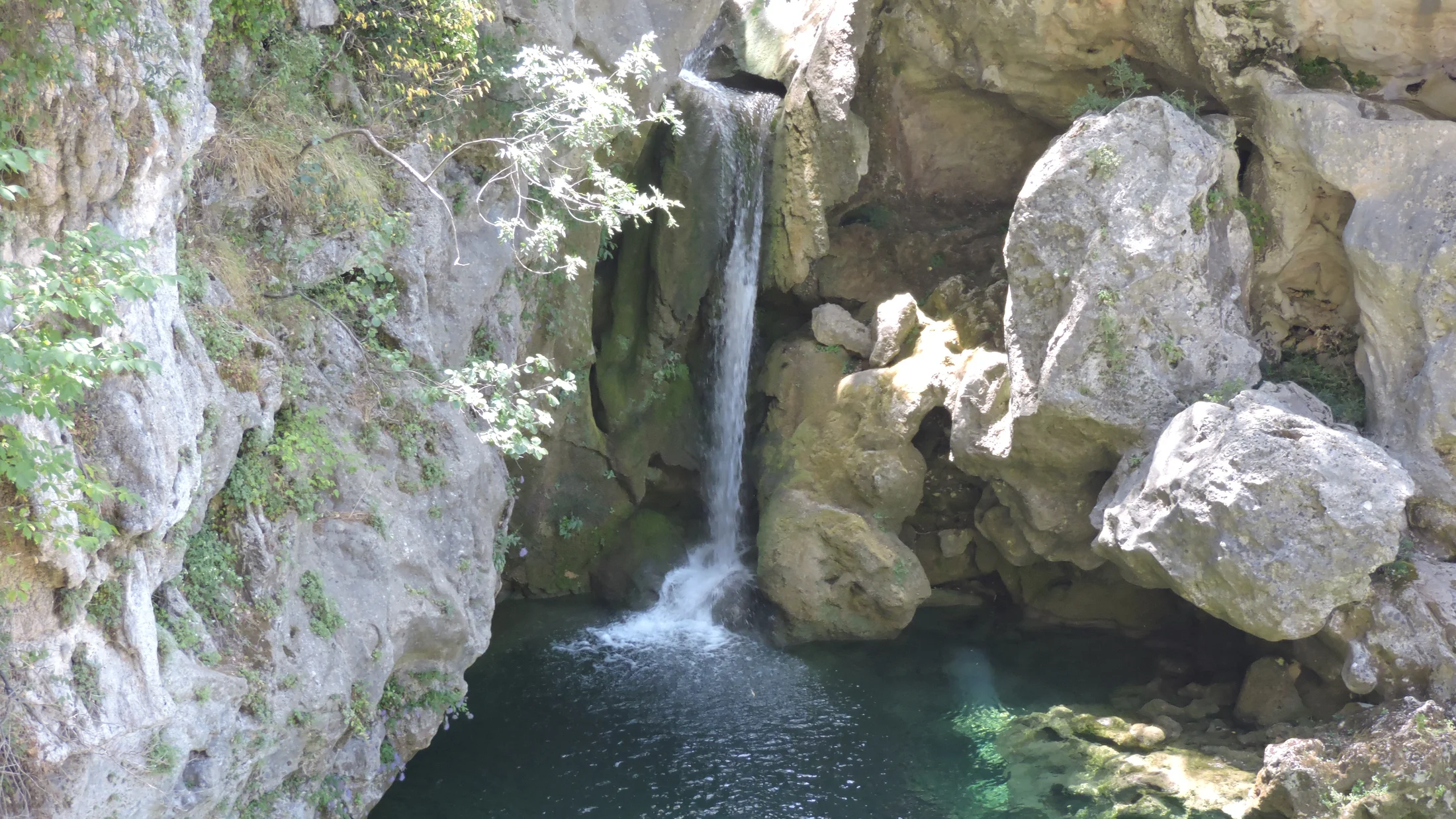
2.Charco de la Cuna: the signature pool
The charco de la cuna is a sculpted basin with glassy green water set in pale limestone, a natural amphitheater that invites rest and reflection. Its shape and shelter make it photogenic in all seasons, with textures revealing themselves in raking light. In summer, it’s a welcome shade stop; in winter, the water’s color can glow deep jade under clear skies.
- Why it stands out: the pool’s form and framing by rock and pine compose a near-perfect scene, a quiet counterpoint to the gorge’s drama. Dragonflies skim the surface like blue sparks in still air.
- Best moments: mid-morning when the sun lifts above the rim, or late afternoon when edges soften and reflections strengthen.
- Responsible behavior: avoid soaps or sunscreen-heavy dips in still water, step only on durable rock or gravel, and pack out every crumb of litter. If crowded, take your break a few minutes upstream to keep the spot serene for everyone.
3.Borosa headwaters: recognizing the river’s source
The nacimiento río Borosa is not a single faucet-like spring but a complex high area where waters collect and issue from karst (limestone) conduits. As you approach, you’ll notice increased seepage, channels, and sometimes engineered features controlling flow near reservoirs. Read the landscape: water rising from stone, cool microclimates, moss, and cattails tell you you’re in the river’s nursery.
- Why it matters: headwaters are sensitive; their clarity and flow sustain the valley’s pools, trout, and riparian plants downstream. The air here has the clean chill of a shaded cave mouth.
- Visitor etiquette: keep distance from any intakes or infrastructure; do not wade in spring outlets; and yield quiet—these are living waterworks.
- Photography: capture textures—wet limestone, dripping moss, and the fine bubbles of emerging flow—rather than stepping into fragile seeps for a centered shot.
Many hikers find the climb to the source deeply satisfying: it makes the river’s life cycle tangible, from whitewater chutes to still reaches and back to the stone it rises from.
4.Cascades and pools: resting places and cool corners
Between the gorge and the high springs, a series of smaller cascades and pools offers natural pauses. They lack the fame of the gorge or the source but reward those who linger—especially on hot days when a breeze pulls coolness into shady nooks. Use a patient eye: small falls with fanned rock or a half-submerged trunk can deliver your favorite image of the day.
- Where they cluster: in the middle reaches after the Cerrada de Elías, where the valley widens and the gradient softens.
- Safer bathing: stick to slow, shallow edges without current; avoid slick ledges and refrain from jumping; supervise kids closely and keep dogs leashed.
- Best times: early or late to dodge midday crowds, or on overcast days when water color holds and glare drops. The scent of crushed mint rises from riparian patches when you brush past.
5.Lookouts and walkways: where to frame the panorama
While the Borosa is an intimate river trail, there are moments for wider views. Short rises above the river reveal terraces of pine, scalloped limestone ridges, and the silver ribbon of water. The boardwalks themselves are strong compositional elements—leading lines for photographs that guide the eye through space.
- Panoramic hints: pause on higher steps exiting the gorge, or at bends where the valley opens; look back down-valley to frame receding ridges.
- Photo tips: shoot the boardwalk edge as a diagonal leading line; for waterfalls, use a small flexible tripod and 1/8–1/2 second exposures in shade to blur water. At dusk, the sky’s pastel wash sets off pale rock like watercolor.
- Integrating stops: mark two or three photo halts on your
sendero río Borosaplan—one in the gorge, one at a mid-valley pool, and one near the upper ascent—so you keep a steady hiking rhythm.
Activities and Safety: Make the Most of Your Day
Photography and the best light
Light changes fast in a narrow valley, so plan shots by section. In the Cerrada de Elías, early morning provides gentle contrast and fewer people; mid-morning works well at the Charco de la Cuna; and later afternoon softens highlights on mid-valley pools. If you intend to push high, reserve time for textures and details near the springs rather than broad vistas.
- Equipment: keep it light—phone plus a small wide-to-normal prime lens, a pocketable tripod or clamp, a microfiber cloth, and a polarizer for glare on water. The cool of the gorge preserves color, but condensation can mist on glass.
- Framing ideas along the sendero río Borosa: capture boardwalk curves as leading lines; shoot low across still water for reflections; and frame cascades behind leaves for a natural vignette.
- Etiquette: step out of the way on narrow sections, share popular angles, and avoid blocking the boardwalk for more than a few seconds.
Responsible dipping and low-impact rules
A cautious dip can be refreshing, but Borosa pools are small, and the ecosystem is sensitive. Choose slow, shallow margins away from inflow or outflow, and keep bodies and clothes out of spring outlets entirely. Skip soaps and shampoos—biodegradable claims don’t apply in cold, low-volume streams—and rinse sunscreen well before leaving the car.
- Core principles:
- Pack out everything, including tissues and fruit peels.
- Stay on durable surfaces (rock, gravel, established trail); never build dams, stone seats, or cairns.
- Keep sound low; wildlife and fellow hikers share the same narrow valley.
- Dogs on leash at all times; pick up and carry out waste.
- Community note: local rangers and residents work hard to keep water clear for everyone—your careful choices honor that effort. Sun-warmed rock feels rough and clean under your palm as you rise from a careful sit.
Gear, safety, and accessibility
Even for a straightforward river hike, essentials matter. Wear grippy hiking shoes, carry 1.5–2 liters of water per person for the short-to-middle options (more in midsummer), and bring sun protection, light layers, and a small first-aid kit. Download an offline GPS map and carry a power bank for your phone.
- Essentials checklist:
- Footwear with tread (trail runners or light boots)
- Water and snacks; lunch if going high
- Sun hat, sunscreen, sunglasses
- Light rain shell or wind layer
GPSapp with offline map; paper map backup if possible- Poles for added stability, especially on the descent
- Headlamp in case your return runs late
- Best seasons: spring and autumn for stable temperatures and flowing water; winter can be cold and icy in shade; summer brings heat and crowds—start at sunrise. The river’s breath is cool even on hot days when you dip your fingers at a bend.
- Accessibility: the first track section is wide but not fully adapted; boardwalks are narrow with steps and exposure; this is not a wheelchair-accessible route. Families often walk to the start of the gorge and turn back before the tighter spots.
- Weather risks: flashier flows and slippery rock after rain; strong sun and dehydration in midsummer; early dusk in winter. If conditions look unsettled, shorten your plan and stay to the wide lower track.
Frequently Asked Questions
How long does the Río Borosa trail take, really?
For most hikers, the out-and-back to the Cerrada de Elías and nearby pools takes 2.5–3.5 hours in total, including photo pauses and a short rest. If you continue to the intermediate waterfalls area, budget 4–5.5 hours round trip at a relaxed pace. The full journey toward the Borosa river source in the high Aguas Negras sector typically takes 7–9 hours round trip for fit hikers, sometimes longer if crowds slow progress in the gorge.
Your personal time depends on pace, heat, and how long you linger at photo spots like the boardwalks and the Charco de la Cuna. Families may move more slowly, especially on narrow sections, and hot summer days can stretch breaks. Start early, set a firm turn-around time, and remember the return still requires focus even though it trends downhill. River spray cools the skin for a moment as you check the clock at a bend.
- Quick guide:
- To Cerrada de Elías: 2.5–3.5 h
- To mid-valley waterfalls: 4–5.5 h
- To high source sector: 7–9 h
- Add 15–20% time for heavy crowds, heat, or frequent photo stops.
Is the route suitable for children or dogs?
The lower section along the wide riverside track suits many families with school-age children, and the approach to the Cerrada de Elías is manageable with supervision. Inside the gorge, narrow boardwalks and steps require close attention; hold hands with younger kids and avoid leaning on rails. Strollers are not practical beyond the initial track due to steps, uneven surfaces, and tight sections.
Dogs are commonly seen and must be kept on a short leash for safety and wildlife protection. In the gorge, give way at wider lay-bys and prevent dogs from jumping against rails or into fast current. On hot days, start early, carry extra water, and watch for paw fatigue on rough stone. Children’s laughter echoes softly against the rock when they discover the first tiny waterfall.
If you prefer to avoid the tightest parts, walk to the start of the boardwalks, enjoy the riverside, and turn back before the narrowest passages. For very young children or anyone uneasy with heights and edges, the lower track provides a pleasant and scenic alternative without exposure.
Do I need permits, and are there seasonal restrictions?
No special permit is required for a day hike on the Río Borosa trail under normal conditions. However, the park authority may issue temporary closures or advisories after heavy rain or during maintenance on the Cerrada de Elías boardwalks. In summer, high fire risk can trigger restrictions on certain activities (such as smoking or using stoves) throughout the park.
Wild camping is not allowed; stick to established accommodations in nearby towns and villages. Group activities or guided outings with commercial purposes must comply with park regulations; check with a visitor centre if in doubt. Rangers post updates at information panels and at main centres like Torre del Vinagre. The crisp scent of wet stone drifts from shaded corners where signs warn of damp footing.
Before you go, verify current conditions with:
- Junta de Andalucía park information (Parque Natural Sierras de Cazorla, Segura y Las Villas)
- Torre del Vinagre Visitor Centre staff
- Local tourism offices in Cazorla/La Iruela
Where can I park, and what about access hours?
Parking sits along the short access track at the start of the route off road A-319. Spaces are limited on weekends and holidays, so arrive early—ideally near sunrise—to secure a spot and enjoy the gorge before crowds build. If the main parking is full, do not block the access track; circle back and wait for turnover or shift your plan to a different nearby walk.
There is no fixed gate schedule for the trail itself, but mountain driving, wildlife, and cooler temperatures make early starts the safest and most enjoyable. Stop by the Torre del Vinagre Visitor Centre en route when open to confirm any temporary restrictions on the Cerrada de Elías. Early light glows on the tops of pines while the valley floor stays cool and blue.
- Tips:
- Park only in signed areas; leave space for emergency vehicles.
- Keep valuables out of sight and lock your car.
- Set a turn-around time to finish in daylight, especially in winter.
What gear and footwear are essential?
Footwear with good tread is non-negotiable: trail-running shoes or light boots with grippy soles help on damp boardwalks and rocky steps. Carry 1.5–2 liters of water per person for the shorter options (more in summer), salty snacks, a light lunch if going high, and sun protection (hat, sunscreen, sunglasses). A compact first-aid kit, emergency whistle, and a charged phone with an offline GPS map round out basics.
In shoulder seasons, add a lightweight shell and warm layer for shady sections and windy moments near the springs. Trekking poles ease knees on the descent and steadiness in eroded spots. After rain, a small pack towel keeps lenses and glasses clear. A breath of cool air rises from the river whenever you crouch to tie a lace.
- Essentials list:
- Grippy shoes (trail runners or boots)
- Water and snacks; lunch if continuing high
- Sun hat, sunscreen, sunglasses
- Light shell and insulating layer (seasonal)
GPSapp with offline map; power bank- Poles, small first-aid kit, headlamp
Sources for verification: Junta de Andalucía (Parque Natural Sierras de Cazorla, Segura y Las Villas), Torre del Vinagre Visitor Centre, and Spain’s Instituto Geográfico Nacional (IGN) maps.
Book your experience — discover outdoor activities in Spain with Picuco’s vetted providers.
Conclusion: Water, Stone, and a Path You’ll Remember
The Río Borosa trail compresses a whole landscape into one day: a gentle riverside warm-up, the sculpted Cerrada de Elías boardwalks, tranquil pools, small cascades, and the satisfying climb toward the Borosa river source. You can tailor your outing to time and fitness—from a family wander to the gorge to an all-day push into the high headwaters—without technical demands. Morning light on emerald water, the hush of pine, and the quiet work of gravity on limestone linger long after you’ve left.
Plan with respect for the place and its people. Start early, carry essentials, and check conditions at a visitor centre. Keep your footprint light: stay on the path, leave stones as you find them, and pack out every scrap. A simple thank-you to rangers and local staff goes a long way; they help keep these waters clear and these trails safe for everyone.
If Cazorla hiking trails are on your list, make this your anchor day. Choose the stretch that fits your group, commit to a realistic turn-around time, and give the gorge its quiet. When you return to the trailhead, take one last look at the flowing water—you’ve traced its life from shaded bends to the very place it begins, and that’s a journey worth remembering.