Why These Hanging Walkways Make Hearts Race
You step onto steel mesh, the valley opens below, and the wind hums underfoot. Routes with suspension bridges in Spain mix exposure, movement, and sound in a way that pokes at our balance system and tests our nerve. That gentle sway, the open void, and the drumbeat of your steps together trigger what many call “vertigo,” which, in plain terms, is the unsettling sensation of height and motion combined. In this guide, you will find eight hiking suspension bridges and hanging bridges trails in Spain that reward courage with exceptional landscapes.
We focus on trails where walkways, stairs bolted to cliffs, or suspended spans are a core part of the route, from Montfalcó–Mont-rebei to the famous Caminito del Rey hanging walkway. Each section explains distance, time, difficulty, and whether you must reserve a ticket or permit. You will also learn when to go, how to reach trailheads, and which areas to avoid in rain or high wind. Expect practical, verified information with concrete numbers, because planning removes most surprises on exposed terrain.
These routes spread across canyons in Aragón and Catalonia, river gorges in Valencia and Granada, big limestone walls in Picos de Europa, and cliffy coastlines of Andalusia and the Mediterranean. Metal cool against your palm, you glance sideways and see turquoise water threading the rock like a ribbon. If you are here to be inspired and to plan a real trip, you are in the right place: read on for seasonality, access, lodging, and the eight routes that will likely test, and grow, your comfort with heights.
Picuco te puede ayudar
Does something here catch your eye?
Tell us.
Write to us on WhatsApp or email: we answer questions, find the best options and help you sort out the booking.
Where They Are and When to Go
Spain’s most notable hanging walkways cluster in four big landscapes: the Montsec range on the Aragón–Catalonia border, the Turia and Monachil gorges in the east and south, the karst of Picos de Europa in the north, and a handful of coastal cliff paths. Across these, you will move through Natural Monuments, Natural Parks, and protected canyons, each with their own rules and rhythms. The scent of thyme and wet limestone rises as shade retreats across the canyon wall.
-
Aragón and Catalonia (Montsec/Mont-rebei, Sierra de Guara):
- Montfalcó–Mont-rebei straddles Huesca (Aragón) and Lleida (Catalonia) around the Noguera Ribagorzana.
- Pasarelas del Vero lie by Alquézar in Sierra y Cañones de Guara Natural Park (Huesca).
-
Valencian Community:
- Chulilla’s suspension bridges cross the Turia canyon inland from Valencia.
-
Andalusia:
- Los Cahorros in Monachil skirt Sierra Nevada Natural Park (Granada).
- Caminito del Rey traverses the Gaitanes Gorge between Ardales and Álora (Málaga).
- Coastal cliff paths appear around Barbate and Caños de Meca (Cádiz) and along sections of the Costa Brava/Costa Blanca.
-
North (Castile and León/Basque Country, Asturias/León):
- Salto del Nervión viewpoints sit in the Monte Santiago Natural Monument (Burgos/Álava).
- Ruta del Cares (Picos de Europa) runs between Poncebos (Asturias) and Caín (León).
Best seasons align with stable weather, mild temperatures, and good light:
- Spring (March–May) and autumn (September–November) suit most canyons and the Caminito del Rey; heat is manageable and crowds thinner on weekdays.
- Summer works in high mountain zones like the Cares, but start early to avoid heat and congestion.
- Winter can bring closures for wind or ice; Caminito del Rey often suspends operations on high-wind days (check official notices the morning of your visit).
When to avoid:
- Rain makes metal walkways slick and increases rockfall risk in narrow gorges.
- Strong wind magnifies exposure on bridges; gusts above 40–50 km/h can feel destabilizing even on handrailed spans.
- Peak hours (11:00–15:00 weekends/holidays) bring queues at narrow sections, eroding the experience and increasing wait-time chill in shade.
Permits, capacity limits, and reservations:
- Caminito del Rey requires a dated ticket; capacity is controlled in timed slots and helmets are provided at the entrance.
- Pasarelas del Vero in Alquézar often operate with a municipal ticket and capacity management; in high season, buy early in the day or online when available.
- Montfalcó–Mont-rebei and Chulilla generally do not require formal permits but may limit parking; local councils post temporary rules during busy periods or after storms.
- Monte Santiago (Salto del Nervión) can restrict vehicle access to protect the plateau after rain; approach gates may close when car parks fill.
- Ruta del Cares has no booking system, yet summer weekends see saturated car parks and ranger advisories.
Check current conditions with:
- AEMET weather forecasts (hourly wind and precipitation).
- Official park or municipal websites and visitor centers for closures or ticketing. Reliable planning means fewer surprises and more time feeling the solid rhythm of your feet on steel and stone.
Getting There without Headaches
Most trailheads for hanging bridges trails in Spain lie on secondary roads, and a small detour in planning can save an hour of circling for parking. Arrive early and know your fallback trailhead to keep the day smooth. Morning cool holds the scent of pine resin by an empty dirt lot before the rush arrives.
-
By car (primary accesses and parking):
- Montfalcó–Mont-rebei: Park at Albergue de Montfalcó (Huesca) to tackle the cliff stairs and suspension bridge toward the Congost; or at La Masieta car park (Catalonia) to walk the canyon from the north side. Both fill fast on weekends.
- Chulilla: Use the signed municipal car parks near the village; the route to the suspension bridges descends from the dam track and canyon path.
- Los Cahorros (Monachil): Park at Los Cahorros trailhead or in Monachil village and follow signs along the river.
- Caminito del Rey: Two official access points—north (Ardales, near El Kiosko) and south (El Chorro, Álora). Park at either end and use the shuttle bus (paid) to return to your car after the linear route.
- Pasarelas del Vero (Alquézar): Public car parks at the village entrance; start from the historic center following “Pasarelas” signs down to the river.
- Ruta del Cares: Poncebos (AS-264) and Caín (LE-5207) both have limited parking; arrive before 9:00 on summer weekends.
- Salto del Nervión: Car parks at Monte Santiago (Burgos) and near the Orduña plateau (Álava) lead to signed viewpoints.
- Coastal routes: Use signed lots in S’Agaró or Calella de Palafrugell (Costa Brava) and at Barbate/Los Caños de Meca (Cádiz) for cliff paths.
-
Public transport and common combinations:
- Caminito del Rey: Renfe Cercanías trains stop at El Chorro–Caminito del Rey; from there, use the shuttle to the north entrance, then hike back one-way.
- Monachil (Los Cahorros): Granada city buses connect to Monachil; confirm schedules, then add a 15–25 minute walk to the trailhead.
- Chulilla: Regional buses from Valencia are limited; a rental car or car-share with an early start is more reliable.
- Ruta del Cares: Seasonal buses link Arenas de Cabrales with Poncebos; services vary by month.
- Montfalcó and Alquézar: Public transport is scarce; plan to drive or arrange a transfer with local taxi services from the nearest towns (Barbastro for Alquézar; Puente de Montañana or Benabarre for Mont-rebei area).
-
Signage, alternate starts, and congestion tips:
- Download offline maps and the official GPX when provided; canyon walls kill signal quickly.
- Choose reverse logistics for Caminito del Rey and the Cares to avoid peak entry waves (start earlier from the less popular end).
- For Chulilla and Los Cahorros, starting at daybreak or late afternoon helps you pass through bottlenecks between crowds moving in the opposite direction.
- If main lots are full, do not block access roads; many municipalities fine or close routes after unsafe parking complaints.
With the approach dialed, the hike begins quietly, the crunch of gravel giving way to the clink of steel underfoot.
Where to Stay and How to Plan Stages
Picking a smart base turns a good hike into a relaxed trip, especially when combining two or three routes across regions. The call of swifts over a stone village square at dusk settles your day into place.
-
Bases by route:
- Montfalcó–Mont-rebei: Stay in the Montsec area—villages like Àger, Benabarre, or Tremp—and plan a full day for the cliff stairways and canyon traverse.
- Chulilla: The village itself is the best base, with casas rurales and simple eateries steps from the trailheads.
- Los Cahorros (Monachil): Overnight in Monachil or central Granada for easy bus access and evening tapas.
- Caminito del Rey: Base in Ardales for lakeside calm or Álora/El Chorro for easy train connections.
- Pasarelas del Vero (Alquézar): Sleep in Alquézar to enjoy the old town and beat day-trippers to the river.
- Ruta del Cares: Poncebos, Arenas de Cabrales, or Caín offer a range of rural stays and quick starts.
- Salto del Nervión: Orduña, Amurrio, or the small villages on the Burgos plateau make early visits straightforward.
- Coastal paths: For the Costa Brava, S’Agaró or Calella de Palafrugell; for Cádiz, split nights between Barbate and Los Caños de Meca.
-
Trip planning ideas:
- Weekend combo (north): Day 1 Ruta del Cares out-and-back partial from Poncebos (16 km suggested). Day 2 Salto del Nervión viewpoints (6–12 km options), then return.
- Weekend combo (east): Day 1 Chulilla suspension bridges (8–10 km) early; afternoon swim spots on the Turia. Day 2 Alquézar Pasarelas del Vero (3–4 km) and old town visit.
- Long weekend (south): Day 1 Caminito del Rey (reserve morning slot). Day 2 Los Cahorros (8–10 km). Day 3 Barbate cliff path if you have a coastal extension.
-
Time recommendations:
- Day hikes: 2–4 hours for Pasarelas del Vero, Chulilla routine loop, and Los Cahorros; 3–4 hours for Caminito del Rey; 6–8 hours for full Montfalcó–Mont-rebei traverses; 6–8 hours for Cares roundtrip sections.
- Add buffers for queues, photos, and shuttle connections.
-
Bookings and services:
- Reserve Caminito del Rey tickets several weeks ahead in spring and autumn weekends.
- In small villages, book stays and dinner ahead on holidays; rural eateries often close midweek or keep short hours.
- Fuel up before remote drives (Montsec, Monte Santiago). Carry 2–3 liters of water per person in summer; canyon shade can mislead hydration needs.
- Note healthcare access points: farmacias in base villages, health centers in nearest towns (e.g., Barbastro for Alquézar, Ardales/Álora for Caminito).
With lodging set and tickets secured where required, you can wake calm, step out early, and meet the bridges before the day warms.
Eight Routes That Will Test Your Head for Heights
These eight routes combine suspension spans, hanging walkways, and cliff-edge paths across Spain. In each, you will find the essentials to decide if it fits your level and time. Sunlight flickers through steel grating as river light bounces up into the canyon.
Montfalcó (mont-rebei): stairways and a suspended crossing
The Montfalcó–Mont-rebei route threads the Congost de Mont-rebei with wooden stairways bolted to limestone and a suspension bridge over the Noguera Ribagorzana. Expect airy traverses, tight ledges, and turquoise water far below. The stair sets feel like open balconies cut into the mountain.
- Distance and time: 14–16 km out-and-back from Albergue de Montfalcó to the heart of the Congost (6–7 hours); full traverses to La Masieta make long days. Elevation gain 600–800 m depending on turnaround.
- Difficulty: Moderate–hard due to exposure, stair heights, and length.
- Vertigo factor: High on stairways and the suspended span; continuous handrails help but the void is present.
- Season: Spring and autumn are ideal; start early in summer heat.
- Permits/reservations: No routine permits; parking fills early at Montfalcó and La Masieta.
- Safety notes:
- Keep three points of contact on stair sections.
- Avoid in strong wind and rain; wood and metal can be slick.
- Carry a headlamp if you plan a long traverse with late return.
Pair this with calm kayaking on the reservoirs around Montsec when levels and operators allow, or a starry-night stay in the dark-sky area of Montsec.
Chulilla: suspension bridges and balcony paths above the Turia
The Chulilla suspension bridges route crosses the Turia canyon on two metal spans and follows balcony-like trails cut into pale limestone. Cacti and rosemary scent the warm air as you step onto the first bridge and the river narrows beneath. The feeling is playful exposure with constant railings and short spans.
- Distance and time: 6–10 km depending on start (2–3.5 hours). Common circuits link the bridges with the dam track and canyon floor.
- Difficulty: Easy–moderate; short steep bits and stairs.
- Vertigo factor: Moderate; bridges sway slightly but are short with high handrails.
- Season: Year-round; aim for spring and autumn or early/late summer hours.
- Permits/reservations: None typically, but municipal parking and access rules change—check local notices, especially after storms.
- Safety and crowd tips:
- Weekends bring queues at bridges; start by 8:30–9:00 or after 16:30.
- Watch footing on polished limestone in shade; it can be slick.
Between bridges, pause at miradores high above the green river to watch climbers on orange-tinted walls, then close the loop through fragrant scrub.
Los Cahorros (monachil, Granada): caves, wires, and swinging spans
Los Cahorros Granada packs a lot into a compact gorge: suspension bridges over the Monachil river, low overhangs where you duck or use “handholds” of wire, and polished rock ledges flush with water. In the cool slot, the river chatter echoes like a hidden engine.
- Distance and time: 8–10 km for the classic loop (3–4 hours), with shorter family-friendly there-and-back options to the main bridge.
- Difficulty: Moderate due to scrambling under overhangs and occasional narrow footings; low exposure.
- Vertigo factor: Moderate on bridges; low elsewhere.
- Season: Spring and autumn are best; summer is hot but shaded river sections help.
- Permits/reservations: None generally; parking and access can be regulated on peak days.
- Safety notes:
- Expect wet shoes after rains; ledges can be slippery.
- Tall hikers should bring a cap or helmet if sensitive to bumps under the rock roofs.
Combine with Granada city time—an evening in the Albaicín after a gorge morning feels like two trips in one.
Caminito del Rey (málaga): restored walkways and controlled exposure
The Caminito del Rey is a one-way experience through the Gaitanes Gorge on rebuilt walkways, with one airy hanging walkway segment and a final suspension bridge. The cliffside deck floats hundreds of meters above the river, but the path is wide, fenced, and constantly monitored. Sun flashes off the steel mesh while vultures spiral above the canyon mouth.
- Distance and time: 7.7 km linear (including approaches), 2.5–4 hours total.
- Difficulty: Easy–moderate for fit walkers comfortable with height; the path is engineered and well-maintained.
- Vertigo factor: Moderate–high visually, but safety infrastructure is excellent; the final suspension bridge feels most exposed.
- Season: Year-round with closures for wind/maintenance; spring and autumn offer the best comfort and light.
- Permits/reservations:
- Mandatory dated ticket with hourly slots; purchase in advance, especially weekends/holidays.
- Helmets provided at the entrance; keep them on throughout.
- Access:
- Enter from the north (Ardales) after a short approach tunnel, exit at El Chorro; shuttle bus returns to start.
This is the place to experience “pasarelas vértigo España” in a controlled setting, perfect if you want a first taste of height with guardrails and staff nearby.
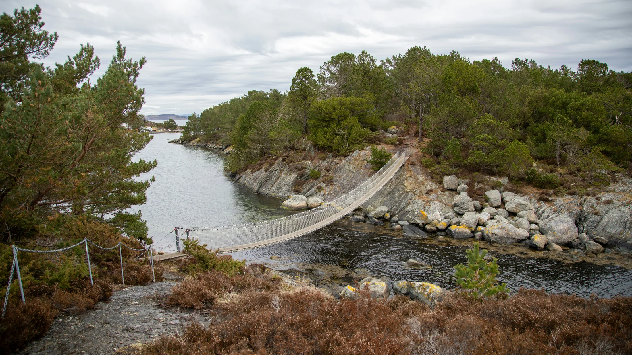
Pasarelas del Vero (alquézar, Huesca): steel above emerald pools
The Pasarelas del Vero weave metal catwalks along the Vero river under Alquézar’s honey-colored walls. Short, scenic, and close to services, it’s a taste of Sierra de Guara’s canyons without committing to full-day hikes. The river runs glassy green below racks of swallow nests on the cliff.
- Distance and time: 3–4 km loop, 1.5–2.5 hours.
- Difficulty: Easy–moderate; short climbs back to town, some stair sections.
- Vertigo factor: Low–moderate; narrow walkways above water with solid handrails.
- Season: Spring to autumn; avoid or postpone after heavy rains when flows run high.
- Permits/reservations:
- Municipal ticketing and capacity control often in effect; buy at the tourist office or official channel when available.
- Helmets may be required and provided; confirm onsite rules.
- Tips:
- Go early to enjoy the river glow without crowds, then tour Alquézar’s alleys and viewpoints.
- Combine with a scenic drive across Sierra de Guara or wine tastings in Somontano.
Short on time? This is one of the easiest entries into hanging bridge sensations, wrapped in a beautiful medieval village.
Ruta del Cares (picos de Europa): narrow ledges and cavern cuts
The Ruta del Cares is Spain’s classic cliff path: 12 km one-way on a ledge carved into the canyon wall between Poncebos and Caín, with tunnels and old maintenance bridges. The drop is real, the path typically 1–1.5 meters wide, and the views relentless. Stone warms to the touch as the gorge opens like a book of strata.
- Distance and time: 12 km one-way (24 km return) with 300–500 m cumulative gain; 3.5–5 hours one-way, 7–9 hours return.
- Difficulty: Moderate for fit hikers with head for heights; the path is clear but long and exposed in sections.
- Vertigo factor: Moderate–high on narrow ledges; suspension bridges are short and sturdy.
- Season: Late spring to early autumn; avoid snow/ice and summer midday heat.
- Options:
- Do a partial out-and-back (e.g., Poncebos to the Culiembro area and return, ~16 km) if you lack a shuttle.
- Start early from the less-crowded end to dodge bottlenecks.
- Safety:
- Rockfall is possible after storms; watch for signed warnings.
- No handrails on most ledges—keep children close and poles short.
The Cares isn’t a classic “rutas con puentes colgantes,” but its tunnels and old bridges deliver the same stomach-flip on edges, with mountain scale all around.
Salto del Nervión hanging viewpoints: cantilever decks over a 222 m drop
At the Salto del Nervión, cantilevered viewpoints project over the lip of the Iberian Peninsula’s highest waterfall (up to 222 m when flowing). Paths across the Monte Santiago plateau lead to fenced metal balconies and cliff-edge miradores, with pastoral beech woods on the way. The air cools instantly as spray drifts back from the void on wet days.
- Distance and time: 6–12 km depending on circuit and car park; 2–4 hours.
- Difficulty: Easy–moderate; gentle plateau walking with short rocky steps near viewpoints.
- Vertigo factor: Moderate on the cantilever decks; high right at the cliff rim if you step off official platforms—don’t.
- Season: Late winter to spring and after heavy rains for a flowing waterfall; summer is often dry.
- Permits/reservations: None, but vehicle access may be restricted after heavy rain or when car parks reach capacity; check provincial notices.
- Safety:
- Stay behind fences; rock ledges at the rim crumble.
- Wind adds to exposure; brace phones and cameras on open decks.
Even when dry, the cirque view and the gash of the Orduña valley make the platforms worth the walk.
Coastal cliff routes with elevated walkways: sea air and airy edges
Cliff paths along Spain’s coasts sometimes add wooden boardwalks, small suspension spans, or steel-railed platforms where the shoreline collapses into deep water. The sea thumps below like slow heartbeats as wind tugs at your hat brim.
Representative options:
- Costa Brava Cami de Ronda (S’Agaró–Sant Feliu or Calella de Palafrugell sections):
- Distance/time: 6–12 km selected sections, 2–4 hours.
- Difficulty: Easy–moderate; stairs, short bridges, and railed walkways around headlands.
- Vertigo factor: Low–moderate; exposure mostly visual with constant railings.
- Season: Year-round; avoid storm days with heavy swell.
- Cliffs of Barbate–Los Caños de Meca (Cádiz):
- Distance/time: 8–12 km out-and-back on the cliff edge, 2.5–4 hours.
- Difficulty: Moderate due to sand, wind, and occasional boardwalk detours.
- Vertigo factor: Moderate on open cliff edges; some sections have wooden railings and short footbridges.
- Season: Autumn–spring; strong Levante winds in summer can be hazardous.
Tips for coasts:
- Check wind forecasts; gusty days amplify “pasarelas vértigo España” sensations.
- Watch tide/swell notes on noticeboards; spray and salt film make wood slick.
- Early or late daylight flatters photos; midday glare off water can be harsh.
These seafront segments give you airy edges with a salt tang, perfect for an introductory brush with exposure.
What to Do Around These Routes
Beyond the bridges and walkways, these regions reward slower days with canyon swims, village walks, and local food. A bell rings in a hilltop church as smoke drifts from a wood oven down a trouty river bend.
-
Water and canyon activities:
- Montsec/Mont-rebei: Kayaking on reservoirs in calm conditions; guided trips are common in season—confirm wind forecasts and water levels.
- Sierra de Guara: Canyoning in tributaries of the Vero, with routes for beginners to advanced; book certified guides.
- Ardales lakes (near Caminito del Rey): Stand-up paddle or pedal boats in summer.
-
Climbing and via ferrata:
- Chulilla is a world-class sport climbing area; even non-climbers enjoy watching lines on orange walls.
- Sierra de Guara and Montsec feature via ferratas; these require a harness, lanyards, and helmet or a guided outing.
-
Wildlife and landscape photography:
- Vultures and eagles ride thermals above Montsec and Gaitanes Gorge; early thermals (late morning) see the most action.
- Long-lens shots from Salto del Nervión miradores capture the scale of the cirque; bring a cloth for spray on wet days.
-
Villages and gastronomy:
- Alquézar: Somontano wines and olive oils pair with river walks.
- Granada: Post-hike tapas and, time permitting, evening visits to the Albaicín.
- Picos de Europa: Cabrales cheese, ciders, and mountain stews reward long days on the Cares.
- Cádiz coast: Fresh fish, almadraba tuna (seasonal), and sunsets from Barbate’s promenade.
Sample itineraries:
- Half-day: Pasarelas del Vero loop + Alquézar old town + winery stop.
- Full day: Caminito del Rey morning slot + swim or paddle in Ardales lakes + sunset mirador.
- Mountain weekend: Partial Cares hike Saturday + Lagos de Covadonga scenic drive Sunday if weather turns.
Round your trip by visiting local interpretation centers and respecting closures and access signage that help communities manage sensitive terrain.
Safety, Gear, and Difficulty on Suspension Bridges in Spain
Moving confidently on exposed paths is mostly about preparation, pace, and the right kit. The scrape of a trekking pole against steel reminds you that friction, not bravado, keeps you safe.
-
Safety behavior:
- Cross bridges one by one or with recommended spacing; many have posted limits (e.g., max persons at once).
- Don’t run, jump, or stop abruptly for photos on midspan; step to wider bays if provided.
- Keep hands free on narrow ledges; stash bottles and phones before exposure.
- Respect closures after storms or high wind; engineered routes like the Caminito will close if conditions exceed safe thresholds.
-
Interpreting difficulty:
- Look at length, cumulative elevation, surface (metal grating, polished limestone, dirt), and exposure (handrails vs. open edges).
- A “moderate” 8 km route with exposure (Chulilla) may feel harder than a “hard” 12 km forest loop without edges.
- If you are new to heights, start with fenced, staffed routes like Caminito del Rey, then step up to Chulilla or the Vero, and later to Montfalcó or the Cares.
-
Essential gear checklist:
- Footwear: Grippy hiking shoes or boots; avoid slick soles.
- Layers: Windproof shell; canyons funnel gusts.
- Sun: Hat, sunglasses, high-SPF sunscreen.
- Hydration and food: 1.5–3 liters per person depending on length/heat; salty snacks.
- Poles: Helpful for balance on ledges; shorten on narrow sections to avoid snagging.
- Headlamp: For long days or tunnels on the Cares.
- Helmet: Mandatory at Caminito del Rey; sometimes required at Pasarelas del Vero; optional but wise under low overhangs in Los Cahorros.
- Navigation: Offline maps, route GPX, power bank.
- Small first-aid kit and emergency blanket.
-
Photography and timing:
- Shoot early or late for side light in canyons; midday flattens textures.
- Use wrist straps on phones/cameras on bridges.
- Pack a microfiber cloth for spray (Nervión when flowing, coastal paths with swell).
Every step is a decision; keep them small, deliberate, and in control, and the “vertigo test” becomes a steady thread of focus and joy.
Accessibility and Tips for Fear of Heights
Not all “airy” routes feel the same, and many offer ways to test yourself in safe increments. Your breath makes a steady metronome as you count steps to the next bolt or beam.
-
Easiest introductions (handrails, staff, short spans):
- Caminito del Rey: Wide walkways, continuous railings, and monitors on route.
- Pasarelas del Vero: Low walkways over water with regular handholds.
- Coastal boardwalk sections (Cami de Ronda): Frequent railings, low visual drop.
-
Intermediate (short bridges, some narrow paths):
- Chulilla: Short suspension bridges with high railings; some balcony paths without rails but wide enough.
- Los Cahorros: Bridges are manageable; exposure is low, but ducking and edge-walking can feel spicy.
-
Advanced (sustained exposure):
- Montfalcó–Mont-rebei: Stairways bolted to cliff and a longer suspended span.
- Ruta del Cares: Long, unrailed ledges; constant visual drop.
- Salto del Nervión: Cantilever platforms feel exposed to some; most paths to them are easy.
Techniques for managing vertigo:
- Focus your gaze 2–3 meters ahead; avoid staring straight down.
- Use rhythmic breathing: inhale 4 counts, exhale 6–7 counts to settle nerves.
- Break routes into segments (bridge, ledge, corner); rest where it widens.
- Keep a light hand on rails; let legs, not arms, carry balance.
- Hike with a calm partner and agree on signals to pause or turn back.
Mobility considerations:
- Surfaces are uneven and include steps, ladders, and narrow turns; they are generally not wheelchair accessible.
- Strollers are not recommended on any of these routes.
- Some visitor centers (Caminito del Rey) provide clear accessibility details; consult official pages for latest provisions.
Know your line: if wind rises, rain starts, or anxiety spikes, turn around early. There is no loss in choosing another day for the view.
Frequently Asked Questions
Are suspension bridges and walkways in Spain safe?
Yes—on managed routes the structures follow engineering standards and receive periodic inspections by the managing authority (municipalities, regional parks, or concession operators). Walkways like the Caminito del Rey are designed with redundancy, continuous railings, and controlled capacity, and staff monitor conditions for wind or rockfall. In places such as the Pasarelas del Vero, the local council controls access, provides helmets when required, and closes the route after heavy rain. However, safety also depends on user behavior: cross with spacing, avoid sudden movements, and keep children supervised at all times. Distinguish between official, signed bridges and informal or abandoned structures you might find off-route; the latter may not be maintained and should be avoided. If you encounter damaged planks, missing bolts, or “route closed” signs, turn back and report the issue at the nearest visitor office. When in doubt—especially after storms—check official notices the morning of your hike.
Do I need a reservation or permit for these routes?
Some do. The Caminito del Rey requires advance, dated tickets with hourly entries, and it may sell out weeks ahead in spring and autumn weekends. The Pasarelas del Vero in Alquézar often operate with municipal ticketing and capacity limits; buy at the tourist office or via the official channel when available, particularly on holidays. Montfalcó–Mont-rebei, Chulilla, Los Cahorros, the Cares, and Salto del Nervión generally lack formal permits, but access can be temporarily regulated—expect car-park closures on saturated days or gate closures on the Monte Santiago plateau after heavy rain. Always verify on official municipal or park sites the day before your visit, as rules change after storms or during works. If you plan to link routes in peak season, secure the ticketed one first (e.g., Caminito), then build the rest of your itinerary around that anchor date.
What fitness level do I need, and how do I choose the right route?
Match your choice to length, elevation, surface, and exposure. Short, railed routes like Pasarelas del Vero (3–4 km, 1.5–2.5 hours) and the engineered Caminito del Rey (7.7 km, 2.5–4 hours) suit active beginners who are comfortable walking for several hours. Chulilla (6–10 km, 2–3.5 hours) and Los Cahorros (8–10 km, 3–4 hours) add modest elevation and mild scrambling. Montfalcó–Mont-rebei (14–16 km, 6–7 hours) and the Ruta del Cares (12 km one-way) demand more stamina and tolerance for sustained exposure. If you are height-sensitive, start with fenced, staffed experiences, then progress to short exposed segments, and finally to long ledge routes. A month before your trip, build a base: 2–3 brisk hikes per week (60–120 minutes), include stairs or hills, and practice with the backpack you plan to carry. On the day, pace yourself, snack regularly, and keep rests short to stay warm.
Can I do these routes with children or pets?
Yes in some cases, with caution. Family-friendly options include Pasarelas del Vero and parts of Chulilla; both have railings and short spans. The Caminito del Rey accepts children above a minimum age/height set by the operator—check current rules before booking—and provides helmets. Los Cahorros can be fun for kids comfortable with ducking under rocks and crossing bridges while holding a hand. Dogs are not allowed on some routes (e.g., Caminito del Rey) and may struggle with metal grating or narrow ledges on others; always check local rules and your dog’s comfort around heights and crowds. For children, consider harness-style child safety reins on exposed sections, keep them between adults on bridges, and avoid peak hours to reduce queue stress. Skip long, unrailed ledge routes like the full Cares or Montfalcó with small kids or nervous dogs; pick shaded, short sections instead and turn back when attention fades.
What should I do in bad weather or an emergency?
Check forecasts the night before and morning of your hike using AEMET and local park notices; pay special attention to wind, thunderstorms, and recent rainfall. If rain intensifies or gusts rise mid-route, prioritize sheltered sections: pause in wider bays, avoid midspan stops on bridges, and turn around at the first safe widening. Learn the local emergency number—112 in Spain—and carry an offline map with your planned exit points and trail junction names; canyon walls often kill signal. In case of injury, stabilize in a safe area away from edges, insulate the person from ground moisture, and call 112 with clear location references (route name, nearest signed waypoint, approximate distance from trailhead). Useful tech includes a charged phone, power bank, and offline maps; in remote areas, a basic whistle helps attract attention. After storms, be vigilant for rockfall and closures posted at trailheads; if closures are in place, choose a lower, non-exposed alternative for the day.
Book your experience — discover verified active tourism activities across Spain with Picuco’s trusted partners.
Conclusion
Suspended spans, cliff stairways, and airy ledges deliver a rare blend of adrenaline and awe when you meet them prepared. With the right season, an early start, firm-soled shoes, and a measured pace, “suspension bridges Spain” becomes less a dare and more a doorway to river-carved worlds. One breath, one step, one glance into space, and suddenly the landscape feels bigger because you’ve crossed it at its edges.
Choose your level—engineered comfort on the Caminito del Rey, family-friendly Pasarelas del Vero, lively bridges at Chulilla, or the sustained drama of Montfalcó and the Cares—and build the day around weather, light, and rest. Respect local rules, thank the communities keeping these paths open, and leave places better than you found them. When you are ready to turn plans into action, explore activities and guided options through Picuco, and then come back for more routes, safety checklists, and regional guides that help you roam Spain’s wild corners with confidence.