Why Los Cahorros De Monachil Captivates First-time Visitors and Regulars Alike
Start here if you want a wild gorge, hanging bridges, and cold river pools minutes from Granada. Los Cahorros Monachil is a narrow limestone-conglomerate canyon carved by the Monachil River on the western flank of Sierra Nevada Natural Park, and locals use “cahorros” to describe tight gorges where rock presses close. Couples, families, photographers, and trail runners come for the footbridges, shaded paths, and splash-friendly eddies that make a half-day feel like a full escape. One breath at the canyon’s entrance smells of wet stone and minty riparian shrubs.
You’ll find a classic loop that threads under overhangs, across suspension bridges, and past natural pools where summer crowds cool off. The route is unique near Granada because it keeps water, shade, and drama within a modest distance, then climbs to open views of whitewashed Monachil and the snowy Sierra in season. Expect short sections with metal handholds, a few duck-under ledges, and well-trodden trail that remains close to the river for much of the way. Sun flickers through poplars while the water hums below your steps.
In this guide you’ll get exactly what you need: how to get to Cahorros from Granada by car or bus, where to park, the best months and times of day, clear route descriptions, and safety pointers for bridges, pools, and caves. You’ll also see nearby rural stays—useful if you want sunrise solitude or a late golden-hour photo shoot—plus answers to the most common questions before you lace up. A few minutes of planning pays off here, so keep this open while you look at a map or check the bus timetable. If you move early and carry layers, you’ll walk in cool air, hear the river’s low murmur, and return with wet ankles and a camera full of canyon light.
Picuco te puede ayudar
Does something here catch your eye?
Tell us.
Write to us on WhatsApp or email: we answer questions, find the best options and help you sort out the booking.
Where It Is and How to Reach It from Granada
Los Cahorros sits in the municipality of Monachil, about 8–10 km southeast of Granada, on the northwestern edge of Sierra Nevada Natural Park (protected since 1989 by the Junta de Andalucía). The gorge begins above Monachil Pueblo and threads east-southeast into the foothills, where the Monachil River has cut through cemented cobbles to form ledges, caves, and narrow passages. Water gurgles around willow roots while swifts stitch the air between rock walls.
- Nearest city: Granada (Andalucía)
- Driving distance: 20–25 minutes from Granada center in light traffic
- Protected area: Sierra Nevada Natural Park and Natura 2000 network
- Map resources: Ayuntamiento de Monachil trail panels onsite; Sierra Nevada Natural Park visitor info; standard digital maps show “Los Cahorros de Monachil” and “Aparcamiento Los Cahorros”
Check current access notes with the Ayuntamiento de Monachil and the Sierra Nevada Natural Park for any temporary restrictions due to rockfall prevention, high fire risk, or maintenance.
By car: simple route, driving time, and main entries
If you’re wondering how to handle “cómo llegar Monachil desde Granada”, the easiest drive leaves Granada center on the ring road toward Sierra Nevada, then drops into Monachil Pueblo. From the city, take the A-395 (Ronda Sur) toward Sierra Nevada, exit for Huétor Vega/Cájar/Monachil, and follow signs to Monachil Pueblo via the GR-3202. Continue through Monachil to Avenida de los Cahorros, which leads to the main trailhead area. The curve-rich local road is narrow near the village; drive slowly and yield on pinch points. The wind smells of rosemary on the final bends.
- Distance/time: ~9 km, 20–30 minutes depending on city traffic
- Reference points: A-395 → GR-3202 → Monachil Pueblo → Avenida de los Cahorros
- Avoid in poor conditions: Unpaved spurs that climb above the gorge; they’re unsuitable after heavy rain and can ice over in rare winter cold snaps
- Winter note: Snow rarely reaches the village, but early mornings can be frosty; the A-395 toward the ski area may carry snow chains advisories even when Monachil is clear—check DGT road updates before setting out
If you use navigation, set “Monachil — Avenida de los Cahorros” and then follow local signs to parking at the end of the avenue.
By public transport: bus lines, frequency, and where to get off
Granada’s Metropolitan Transport Consortium runs frequent buses to Monachil from the city, making the trip straightforward without a car. Lines serving Monachil typically include Granada–Monachil services (commonly signposted as 181/183 depending on schedule blocks; verify on the Consorcio de Transporte Metropolitano Área de Granada site). Buses depart from central Granada stops near Paseo del Violón/Palacio de Congresos and Camino de Ronda, with a travel time of about 25–35 minutes. The bus door sighs open to the smell of bread and coffee near the village plaza.
- Get off at: “Monachil Pueblo” (center) or “El Puntarrón/Avenida de los Cahorros” when available; from either, it’s 10–20 minutes on foot to the trailhead
- Frequency: Roughly every 20–60 minutes daily; reduced service on Sundays/holidays
- Return: Same stops back to Granada; last buses are earlier on Sundays—check ahead
For early senderismo Monachil starts, catch one of the first morning buses to enjoy a quieter gorge and cooler temperatures. Confirm updated timetables and fares with the Metropolitan Transport Consortium before travel.
Coordinates, trailhead, and parking options
Trail access concentrates at the end of Avenida de los Cahorros in Monachil Pueblo. The main parking areas are small village lots and shoulder parking near the recreational area; they fill quickly on spring weekends and summer afternoons. River air is cool and damp when you step out of the car.
- Main parking (search “Aparcamiento Los Cahorros”): common map pin near
37.1326, -3.5409(verify in your map app) - Trailhead reference: panels and signs near the end of Avenida de los Cahorros; the first suspension bridge sits upstream within 15–25 minutes of walking
- Capacity/cost: Limited free street parking plus small public lots; no formal fee at time of writing—respect local signage and blue zones if implemented seasonally
- Peak hours: 10:30–15:30 on weekends/holidays; arrive before 09:00 or after 17:30 for easier parking
- Alternatives: Park in Monachil Pueblo center and walk 10–20 minutes to the start; avoid blocking farm tracks and private drives
If you plan the whole journey—cómo llegar Monachil desde Granada, parking, and bus times—save your map offline in case of spotty reception in the canyon.
When to Go, Daily Schedules, and How Long the Route Takes
Spring and autumn are the sweet spot for light, flow, and uncrowded paths. March–May delivers fresh water volume, green riverbanks, and 12–22°C afternoons; October–November brings stable weather, tawny leaves, and 14–20°C highs. In both windows, the pools feel brisk but tolerable, and the bridges stay quieter early and late. The gorge smells of damp rock and crushed bay leaves after a spring shower.
Summer is popular for swimming; expect 28–36°C in Granada, with the gorge several degrees cooler in the shade. Water temperatures hover around 14–18°C depending on flow, and crowds peak from late morning through mid-afternoon. Plan to start by 08:00–09:00 or push your walk to 18:00 for golden light and fewer people. Winter can be beautiful and almost empty, with short days, icy morning stones, and occasional frost; carry layers and gloves for metal handholds.
There is typically no permit required for the classic route, but you walk inside a protected area where standard conservation rules apply (no camping, fires, or soap in the river). After heavy rain, sections may be slippery and the river may run high in narrow parts; the Ayuntamiento de Monachil and the Sierra Nevada Natural Park sometimes post caution notices on official channels. In rare cases of rockfall maintenance, short stretches can be closed temporarily.
Use these time guidelines to plan:
- Short out-and-back (first bridge and lower gorge): 2–2.5 hours without swimming stops
- Classic circular (lower gorge + high return path): 3–4 hours at a relaxed pace
- Extended variant into upper Cahorros: 4.5–6 hours with photo and snack breaks
Best daily windows:
- Early birds: 07:30–09:30 start for solitude and cool air
- Photographers: One hour after sunrise for soft side-light in the gorge; 60–90 minutes before sunset for warm backlight on the upper path
- Swimmers: Midday for maximum warmth, bearing in mind crowds and sun exposure
In summer, carry 1.5–2 liters of water per adult; in shoulder seasons 1–1.5 liters can suffice with snack breaks. If the forecast flags thunderstorms, avoid narrow canyon sections and postpone—flashier flows can rise quickly in constricted bends.
Where to Stay: Rural Bases Near the Gorge and in Granada
Sleeping near Monachil pays off with an empty bridge at dawn and shaded trails before the day warms up. The municipality has two distinct zones—Monachil Pueblo (the old village up the valley) and Barrio de Monachil (lower, closer to Granada)—plus a constellation of rural homes on the slopes and easy city options in Granada. A rooster’s call and the smell of woodsmoke often greet early risers in the village.
Consider these areas:
- Monachil Pueblo
- Why stay: 10–20 minutes’ walk to the trailhead; quiet streets and local bars
- Best for: hikers, families with early starts, photographers chasing sunrise
- Lodgings: small hotels, guesthouses, and licensed rural homes; book early on spring weekends
- Barrio de Monachil and Cájar
- Why stay: quick drive or bus to the village; more dining variety
- Best for: budget travelers, groups wanting easier parking
- Lodgings: apartments and suburban guesthouses
- Granada historic center/Realejo
- Why stay: culture, tapas, and late-night strolls; 20–30 minutes by car/bus to the trail
- Best for: couples splitting days between city and nature
- Lodgings: hotels from simple to boutique; confirm early breakfast if you want a dawn start
- Sierra Nevada foothills (La Zubia, Huétor Vega)
- Why stay: rural feel with services; fast road links to the A-395
- Best for: multi-day hikers, families mixing several trails in the area
- Lodgings: campgrounds, rural apartments, and farm stays
A quick comparison helps you choose:
| Base area | Drive/walk to trail | Vibe | Ideal for |
|---|---|---|---|
| Monachil Pueblo | 10–20 min on foot | Quiet, village rhythms | Hikers, families, photographers |
| Barrio de Monachil | 10–15 min by car/bus | Suburban, more services | Groups, budget travelers |
| Granada center | 20–30 min by car | Historic, lively evenings | Couples, culture + nature |
| La Zubia/Huétor Vega | 15–25 min by car | Semi-rural, spacious stays | Multi-trail itineraries |
Booking tips:
- Spring and autumn weekends fill fast; reserve 1–3 weeks ahead for village stays.
- In summer, look for places with shade or a small pool to cool down after hiking.
- Photographers: choose Monachil Pueblo to step onto the trail in first light without driving.
- Families: apartments with kitchenettes simplify early breakfasts and picnic prep.
- Always confirm parking details and early check-in/late check-out if you plan around sunrise/sunset.
If you plan to add other Granada swimming spots to your itinerary (like river dips in nearby valleys), a base in the foothills keeps drives short while avoiding city traffic.
The Route at a Glance: Layout, Distance, and Difficulty
The classic loop threads the lower gorge to the longest bridge, curls under overhangs with metal handholds, then climbs the south slope for a panoramic return. Expect 7.5–8.5 km total with about 200–300 m of cumulative gain and 3–4 hours of walking time depending on stops. River spray beads on your forearms in the narrowest bend.
- Terrain mix: riverside path, short walkways, natural rock ledges, and stepped dirt on the return
- Waymarking: local directional signs and panels near junctions; follow “Los Cahorros” and “Cahorros Altos”
- Exposure: brief ledge sections with cables/handholds; duck-under overhangs demand balance and a small backpack
Step-by-step layout
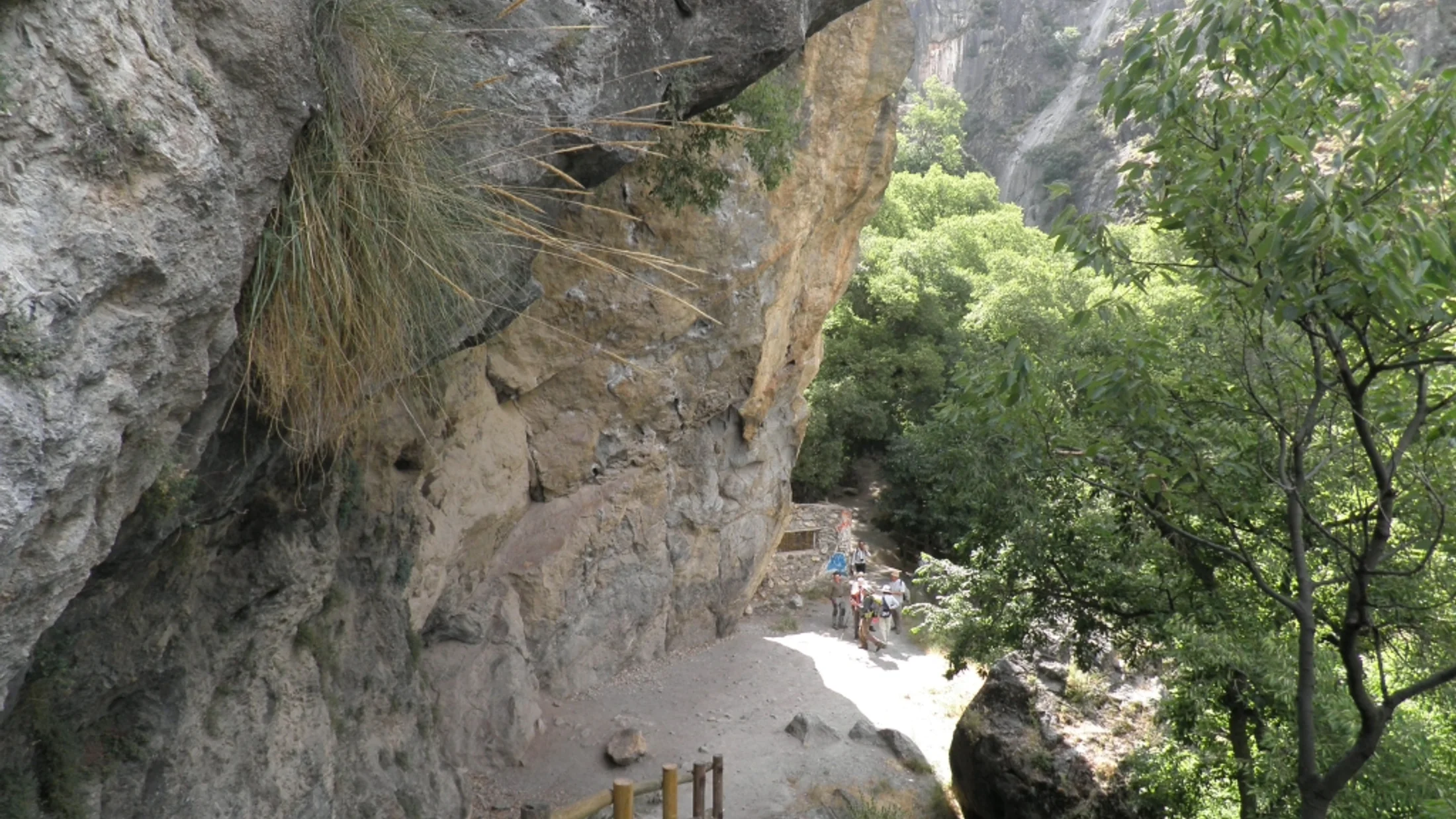
Start at the end of Avenida de los Cahorros and follow the riverside track upstream toward the first suspension bridge. Cross the long bridge and turn right to hug the river’s true left bank through the gorge, where cables and carved steps ease passage under bulging rock. The cool shadow smells like wet chalk after recent flow.
Continue to narrow pass-throughs beneath overhangs; in one corner, short crawl-under moves reward patience and a compact pack. You’ll meet smaller bridges and signposts for “Cahorros Altos”; keep upstream for the lower-gorge highlights, then choose either to climb via the marked path to the south slope or return the same way. Use of hands on polished ledges and the squeeze-under sections increases the ruta Cahorros dificultad slightly, especially after rain.
For the circular return, leave the river at a signed junction, zigzag uphill on a clear dirt path to gain the south-side balcony track, and contour back toward Monachil with views of the village and Sierra Nevada summits in the distance. Rejoin the lane near your starting point.
Distance, profile, and times
Think of the route in three blocks to pace yourself:
- Trailhead to first long bridge: ~1–1.5 km, 15–25 minutes, almost level
- Lower gorge traverse: ~2 km, 45–75 minutes including photos/duck-unders
- Climb and balcony return: ~3.5–4.5 km, 1.5–2 hours, +200–300 m cumulative
Total distance typically lands between 7.5 and 8.5 km door to door, with a rolling profile: flat river approach, punchy mid-route climb, and gentle descending contour. If you carry a GPX, key reference points include the long bridge area and the junction where the path switches from river to hillside; many mapping apps label both clearly. Breeze lifts the smell of thyme on the upper path as you settle into an even rhythm.
Difficulty and variants: easy, moderate, and technical flavors
For most visitors with basic fitness and sure-footedness, the loop rates as easy-moderate. Short ledges, polished rock, and duck-unders add flavor, but cables and steps help in crux spots. Wet soles and heavy packs can increase ruta Cahorros dificultad, so keep loads light and footwear grippy. Cold spray kisses your ankles at river level where the current narrows.
- Easy option: Out-and-back to the long bridge and the first stretch of gorge; ~4–5 km, minimal ascent, 1.5–2.5 hours
- Moderate classic: Full lower-gorge traverse plus hillside return; ~7.5–8.5 km, +200–300 m, 3–4 hours
- Technical-leaning variant: Continue farther into upper Cahorros (Cahorros Altos) before climbing; ~9–12 km, +300–450 m, 4.5–6 hours, with more uneven footing and occasional steeper ramps
If you’re new to ledges or hiking with kids, preview one squeeze-under before committing to the full gorge, and consider reversing if it feels too tight. Polished rock is most slippery after summer swims and spring showers—take short, deliberate steps.
Bridges, Pools, Caves, and Photo Spots Worth Your Time
Los Cahorros concentrates visual highlights into a few compact kilometers, making it a rare blend of playful crossings, swim-friendly eddies, and stone textures close to the city. The river’s low thrum bounces off honey-colored walls as light stripes the water.
1.Hanging bridges: what to expect and how to cross safely
You’ll encounter roughly four to five suspension bridges depending on your variant, with the longest spanning the river near the lower-gorge entrance. The main deck flexes gently underfoot, anchored by steel cables and updated decking that the municipality maintains periodically; wooden planks can feel springy on busy days. A faint metallic creak accompanies each step as the river runs below.
- Safety basics for puentes colgantes Monachil:
- Cross in small groups, spacing 2–3 planks apart to reduce sway
- Hold the side cables lightly; avoid running or bouncing
- Give priority to people already on the bridge; step aside at landings
- Supervise children closely; remove big backpacks if they affect balance
- Timing tip: Reach the long bridge before 10:00 on weekends to avoid queues
If wind is up-canyon, wait a moment for lulls; the flex settles quickly when foot traffic is light.
2.Pozas Cahorros: where to swim and basic etiquette
Several natural pools collect between narrow bends, with deeper bowls forming below small drops and at wider meanders. In midsummer, water temperatures around 16–18°C feel refreshing; in spring and autumn, expect bracing dips at 12–15°C. Sunlight turns the shallows emerald where silt settles behind boulders.
- Popular pozas Cahorros zones:
- Below the main bridge landing and first tight curves upstream
- Wider eddies mid-gorge where gravel banks create entry points
- Small basins near minor cascades upstream of the narrowest passages
- Depths: ~1–2.5 m in deeper bowls; always check before jumping
- Etiquette and safety:
- No soap or sunscreen directly before entering—apply 20–30 minutes beforehand
- Enter feet first; currents can push under overhangs
- Keep noise low; amphibians and birds use these banks for breeding
- Pack out all trash, including fruit peels
On busy days, choose less crowded eddies and share the bank with fishermen if present, giving them room to cast.
3.Caves and rock features: explore with care
Small caves and recesses pepper the gorge, many formed where softer layers eroded within the hard conglomerate—a rock made of rounded pebbles cemented together, like natural concrete. The well-known Cueva de las Palomas sits close to the river path and offers a peek into the canyon’s sculpting without serious commitment. Cool, earthy air brushes your cheeks at a cave mouth even at midday.
- Go-light approach:
- Bring a small headlamp for a quick look; avoid deep penetration into unmarked caverns
- Helmets aren’t necessary for casual peeks but watch your head on low ceilings
- Do not disturb bats or nesting swallows; keep voices low and lights brief
- Ground rules:
- No graffiti, no candles, no fires; do not pry rocks
- Step carefully on slick mud and guano; shoes get very slippery
Rain can change floor conditions overnight—if it looks unstable or muddy, admire from the entrance and move on.
4.Photogenic angles and how to frame them
Los Cahorros rewards simple compositions that use lines and layers: bridge cables for leading lines, the river as a curve, and textured walls for depth. Soft morning light grazes the canyon, while late afternoon warms the upper path with Sierra Nevada in the distance. A faint scent of crushed thyme rises when you kneel to stabilize your shot on a rock.
- Go-to frames:
- Under the main bridge, shoot upward with the deck as a vanishing point
- From a higher boulder at a pool, frame reflections with ripples as foreground
- On the south-side return, include Monachil’s rooftops and far snowfields after winter storms
- Practical tips:
- Early morning = few people on bridges; use a small aperture to keep both deck and cliffs sharp
- Polarizer tames glare on water but costs light in the gorge—balance ISO accordingly
- For senderismo Monachil photo walks, plan a loop: start early for the gorge, linger on the upper path for golden hour
Pack a microfiber cloth—spray and mist will spot lenses fast near the tightest bends.
What to Pack, What to Do, and How to Stay Safe
A little preparation makes Los Cahorros feel playful instead of fussy. Paths are well-trodden but slick in places; shade keeps you cooler, yet sun bites on the return slope. The river’s sound softens footsteps and conversation as you move from bend to bend.
Bring:
- Footwear with grip: trail shoes or light boots with sticky soles
- Small backpack you can slide under overhangs; keep water on the outside pocket
- Water and snacks: 1–2 liters per adult, fruit, nuts, and a packed sandwich
- Sun protection: hat, sunglasses, sunscreen applied early
- Light layers: windshirt, compact fleece for shoulder seasons
- Swim kit: quick-dry towel, lightweight sandals for rocky entries
- Phone with offline map and a small first-aid kit (plasters, blister care)
Family and dog notes:
- Kids: many families enjoy the easy out-and-back; supervise on bridges/ledges and practice duck-unders with hands on cables
- Dogs: permitted on leash; carry waste bags and keep them out of pools where people swim
- Strollers: not suitable—opt for a backpack carrier
Activities beyond walking:
- River photography and macro shots of plants and textures
- Quiet birdwatching: dippers, wagtails, and swifts frequent the gorge
- Short cold-water dips; avoid full submersion for long periods in spring meltwater
Safety and etiquette:
- Move slowly on polished rock; use cables and test foot placements
- Skip bridges during lightning or strong gusts; wait for calmer conditions
- After rain or sudden thaws, water rises—avoid narrowest sections if the current pushes hard along the bank
- Mobile coverage can be spotty; for incidents call
112and move to a wider area if possible - Tell someone your plan and expected return time
- Respect closures and trail work crews; these maintain safe passage for all
Leave No Trace in practice:
- Pack out all waste (including organics and tissue)
- Stay on established paths; trampling increases erosion on fragile slopes
- Keep noise low; wildlife and neighbors appreciate it
- No fires or camping; this is a protected river corridor
A final practical rhythm:
- Start early.
- Take the gorge slow; enjoy bridges and bends.
- Climb to the balcony path for views and an easier walk back.
- Cool feet in a pool near the end if crowds thin.
Frequently Asked Questions
Do I need a permit to hike Los Cahorros?
No permit is required for the classic route at time of writing, but you are inside Sierra Nevada Natural Park, so standard conservation rules apply. Check the Ayuntamiento de Monachil for any temporary closures after heavy rain or maintenance. Fresh rockfall signs smell of dust and warn you to keep moving.
Is the route suitable for children?
Yes for the short out-and-back to the first bridge and part of the gorge, with close supervision on bridges and ledges. Avoid the tightest duck-unders with very small kids or heavy backpacks. A compact carrier works better than a stroller in narrow sections.
Can I swim in the pools?
Yes, in natural pools where people commonly bathe in summer; enter feet first, avoid jumping, and use no soap. Expect 14–18°C water in summer and colder in spring/autumn. Keep a respectful distance from anglers and wildlife.
How do I get to Cahorros from Granada without a car?
Take a Metropolitan Consortium bus toward Monachil (commonly labeled 181/183; verify current codes), get off in Monachil Pueblo or El Puntarrón, and walk 10–20 minutes to Avenida de los Cahorros. Buses run every 20–60 minutes; return services end earlier on Sundays. The bus door’s hiss brings cool canyon air within half an hour.
How long is the hike and what’s the difficulty?
The classic loop is about 7.5–8.5 km with 200–300 m of ascent, taking 3–4 hours at a relaxed pace. Most people rate it easy-moderate; polished rock, short ledges, and duck-unders raise the challenge slightly in wet conditions. Carry water and wear grippy shoes.
Is it dog-friendly?
Yes, keep dogs leashed and away from swimmers and anglers; pack out waste. Mind paws on hot or polished rock and give way on bridges to avoid tangles.
Book your experience — discover active nature activities across Spain with Picuco-verified providers.
Conclusion: A Wild Canyon Next Door to Granada
Los Cahorros distills what many travelers seek near Granada: a half-day of movement, shade, and playful terrain wrapped in a protected river gorge. Bridges sway lightly, pools glitter, and the return path opens views from village roofs to Sierra snow when winter lingers on the heights. The scent of damp stone and thyme sticks with you long after you’ve left the river.
Plan your timing with the seasons, get there early, and choose the variant that matches your energy on the day. If you want to stretch the trip, stay in Monachil Pueblo for a dawn start and an unhurried breakfast afterward, or base in Granada to blend tapas nights with cool canyon mornings. Before you go, check local notices from the Ayuntamiento de Monachil and Sierra Nevada Natural Park, download an offline map, and pack a small bag you can slide under the overhangs. Walk lightly, leave no trace, thank the neighbors who care for these paths, and you’ll help keep this close-to-the-city wonder wild for the next set of curious feet.