What Makes Garganta De Los Infiernos Special
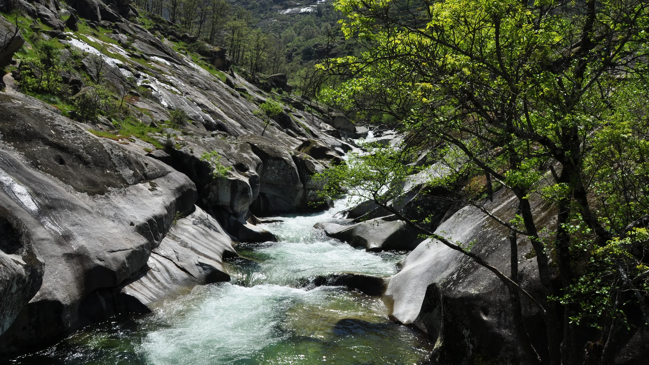
The Garganta de los Infiernos is the wild heart of the Jerte Valley, where cold, clear waters carve smooth bowls into ancient granite. This Natural Reserve in Cáceres (Extremadura) protects high-mountain headwaters, oak and chestnut forests, and a labyrinth of cascades and pools known as Los Pilones. One look at the river polishing rock like glass, and you understand why shepherds named it “Hell’s Gorge” for its thundering waters and mist that once rose like smoke on hot days. You’ll find in this guide the essential routes, the best natural pools, practical advice, and the rules that keep this landscape alive.
Created by the Junta de Extremadura in 1994, the Reserve extends over about 6,900 hectares across the southern slopes of Gredos. Here, altitudes climb from valley orchards to windy crests where broom and heath wave like sea foam. In spring, cherry trees across the wider valley explode into blossom, while within the Reserve, Pyrenean oak, chestnut, birch, and alder stitch green ravines that shelter dippers, otters, and, at dawn, the sure‑footed Iberian ibex. In summer, the granite warms your bare feet as icy water numbs fingers and ankles.
What draws visitors is simple and pure: Jerte Valley hiking at different levels, the sculpted Los Pilones pools for summer bathing, and year‑round viewpoints over a classic V‑shaped valley. Trails range from family‑friendly strolls to daylong ridge traverses, and the water invites both photographers and strong swimmers to explore. The granite potholes you’ll see—circular basins drilled by pebbles and sand in swirling currents—are a textbook of river geomorphology made visible. Plan well, and you can move at your own pace: start early, take only what you need, and leave every rock and eddy as you found it.
Before you go, set your expectations. This is a protected area with seasonal crowds, parking limits, and strict no‑fire, no‑camping rules designed by locals who farm cherries, manage pastures, and guide visitors. If you’re wondering how to visit Garganta de los Infiernos responsibly, you’ll get clear directions, route details, safer Los Pilones swimming spots, and practical tips to avoid heat, crowds, and slippery granite. The water is cold, the rock is slick, and the welcome—when you treat the place gently—runs warm.
Picuco te puede ayudar
Does something here catch your eye?
Tell us.
Write to us on WhatsApp or email: we answer questions, find the best options and help you sort out the booking.
Essential Information and How to Get There
Garganta de los Infiernos sits in the Jerte Valley, northern Cáceres, Extremadura, on the south face of the Sierra de Gredos. The main visitor orientation point and trailhead area lies just above the village of Jerte along the N-110 (the valley road connecting Plasencia with Ávila). For navigation, the primary parking and information area stands near 40.224°N, 5.773°W, with Los Pilones about 3–3.5 km upstream on foot. Morning light glints off alder leaves here like coins in a fast stream.
- Nearest reference villages:
- Jerte (direct access to Reserve trails)
- Cabezuela del Valle (services and river bathing areas)
- Tornavacas (high‑valley access near the pass)
- Navaconcejo (access to side gorges and services)
- Province: Cáceres, Extremadura
- Reserve: Garganta de los Infiernos Natural Reserve (Junta de Extremadura, 1994)
By car, there are two classic approaches:
- From Madrid (approx. 2.5–3.5 h):
- Option 1:
A-5to Navalmoral de la Mata,EX-A1to Plasencia,N-110north to Jerte. - Option 2 (scenic):
A-6/AP-6to Ávila,N-110south via Barco de Ávila and Puerto de Tornavacas.
- Option 1:
- From Salamanca/Ávila (approx. 1.5–2.5 h): Follow
N-110south to Tornavacas and down into the valley. - From Cáceres/Seville:
A-66to Plasencia, thenN-110up‑valley.
Parking and access notes:
- The Reserve’s main parking areas fill fast in spring weekends (blossom season), long weekends, and summer (bathing season).
- In peak times, managed parking and road controls may limit capacity; once full, access closes until turnover.
- If lots are full, park in Jerte or Cabezuela and walk, take a local taxi, or cycle the
N-110shoulder with care.
Public transport summary:
- Regional buses link Plasencia with Jerte, Cabezuela del Valle, Tornavacas, and Navaconcejo several times daily on weekdays, with reduced weekend service. From village stops, expect 20–45 minutes of additional walking to trailheads depending on route.
- Plasencia connects by bus and rail to major cities in Extremadura and beyond. Always confirm timetables on the Extremadura transport portals or at village tourist offices because seasonal schedules vary.
When to go:
- Late March to mid‑April (variable): Cherry blossom across the broader valley; trails get very busy; parking tight; temperatures mild but riverside shade stays cool.
- May–June: Prime hiking with flowing waterfalls, green canopy, and moderate temperatures.
- July–August: Best for natural pools Jerte enthusiasts; water is low but still cold; midday heat can exceed 30°C at valley floor—start at sunrise or late afternoon.
- September–November: Quieter trails, chestnut and oak color, stable weather windows.
- Winter: Upper routes may see ice or occasional snow; streams run strong; check conditions and avoid icy slabs.
Crowd‑avoidance strategies:
- Arrive before 9:30 in peak season and head straight to Los Pilones before it crowds.
- Choose midweek days whenever possible and target shoulder hours (sunrise or after 17:30 in summer).
- Use Tornavacas or Cabezuela as bases to spread pressure and approach lesser‑used trailheads.
Safety and comfort:
- Granite slabs polish to ice‑rink smoothness; grippy footwear matters. The water can be 12–16°C in summer—invigorating but numbing after minutes.
- Mobile coverage varies; download offline maps and tell someone your plan.
- Carry 1.5–2 liters of water per person in summer; shade can be sparse on south‑facing slopes.
Helpful references
- Legal status: Reserva Natural Garganta de los Infiernos (Junta de Extremadura, 1994; provincial Cáceres).
- Trail and seasonal advisories: ask at the Centro de Interpretación in Jerte or municipal tourist offices in Cabezuela/Jerte.
- Weather: AEMET forecasts for Jerte/Plasencia region (heat and storm alerts).
Where to Sleep and Eat in the Jerte Valley
You’ll find a broad range of rural stays and honest cooking in villages hugging the river, from Jerte to Tornavacas. Nights are quiet here, and mornings begin with birdsong and the soft clatter of cherry crates. Choose your base for the trip you want: quick access to Garganta de los Infiernos trails, a family‑friendly weekend with river swims, or a hiker’s hub for long ridge walks.
Best bases and types of stays
Four villages work especially well for the Reserve and for senderismo Valle del Jerte:
- Jerte:
- Closest to the main Reserve parking and Los Pilones trail.
- Good for sunrise starts, quick returns after swims, and short stays.
- Mix of rural houses, small hostales, and apartments; limited but convenient parking.
- Cabezuela del Valle:
- Larger services, river bath areas, and traditional architecture.
- Balanced base for families: shops, picnic spots, playgrounds.
- Rural houses and guesthouses; easy access to mid‑valley routes.
- Tornavacas:
- High‑valley feel near Puerto de Tornavacas; cooler nights in summer.
- Excellent for panoramic hikes and combining with Gredos passes.
- Small inns, apartments; quieter after dark.
- Navaconcejo:
- Gateway to side gorges and orchards; easy parking and services.
- Handy for combining hikes with relaxed river days.
- Rural houses and campgrounds nearby.
Types of accommodation:
- Rural houses/apartments: Self‑cater flexibility; ideal for families or small groups.
- Small hotels/hostales: Central, simple, often breakfast included; good for short breaks.
- Campgrounds/bungalows: Budget‑friendly and social; pools and shade; great for summer.
- Mountain refuges or rustic stays: For hikers prioritizing early starts and proximity to trailheads.
Price guidance:
- Rural houses and small hotels commonly range 60–150 € per room/night depending on season; holidays cost more. Confirm current rates in Picuco before booking.
Tip by trip type:
- Families: Base in Cabezuela or Navaconcejo for services, shade, and easy river access.
- Hikers: Jerte or Tornavacas for early trail starts and cooler nights.
- Weekend travelers: Jerte for 36‑hour immersion near the Reserve.
Where to eat: traditional kitchens and easy picnics
Food in the valley is seasonal and proud: cherries from late spring, goat and pork stews when nights cool, and river trout where permitted. The aroma of wood‑fired grills drifts from village squares like a friendly beacon.
- Traditional restaurants and ventas:
- Expect migas, grilled ibérico cuts, caldereta (stew), and trucha if available.
- Book ahead in blossom season and weekends (13:30–15:30 lunch rush).
- Quick eats and take‑away:
- Many bars prepare bocadillos, tortillas, and salads for picnics.
- Bakeries in Cabezuela and Jerte open early—perfect for pre‑hike supplies.
- Special diets:
- Vegetarian options often include local cheeses, vegetable stews, and salads; ask for off‑menu flexibility.
- For gluten‑free needs, phone ahead; small kitchens appreciate notice.
- Picnic etiquette:
- Use designated picnic areas near river zones around towns.
- Pack out all waste; store organics securely to avoid wildlife disturbance.
Grocery stops for trail days:
- Stock water, fruit, nuts, and sun protection in village supermarkets before you climb.
- In heat, freeze a water bottle overnight; it doubles as an ice pack until noon.
The Best Hiking Routes in Garganta De Los Infiernos
From short strolls to long traverses, the Reserve offers trails for many levels, most on well‑trodden paths across granite and oak shade. Boots crunch over dry leaves in autumn like toasted paper. Below, you’ll find the core itineraries for planning, with distances, elevation, and the kind of terrain to expect.
1.Los Pilones loop: short circuit to the sculpted pools
- Overview: The signature route to the iconic Los Pilones pools and viewpoints, returning on a circular variant.
- Start/parking: Main Reserve parking above Jerte near
40.224°N, 5.773°W. - Distance/time: 6–7.5 km loop; 2–3 hours total.
- Elevation gain: 250–320 m.
- Difficulty: Easy to moderate (stone steps, some polished granite slabs).
- Waymarking: Clear posts and signs; high foot traffic.
Route notes:
- From the parking/visitor area, follow the well‑marked path uphill through oak and heather.
- Reach the upper viewpoint over Los Pilones, then drop to the channel where water sculpts the granite.
- For the loop, continue downstream on the opposite bank (where indicated), rejoining the ascent path near the trailhead.
Highlights:
- The “giant’s bathtubs” carved by swirling gravels—classic river potholes—show the gorge’s patient craftsmanship.
- A mid‑loop mirador looks down into a ladder of emerald bowls and flumes.
Photo and swim tips:
- Shoot early for soft light and fewer people; late afternoon glow also pleases.
- Surfaces are polished; approach pools slowly; avoid jumping (hidden rocks move with floods).
- Pack lightweight sandals with grip for wet rock, but hike in sturdy shoes.
Parking fill‑up is common by mid‑morning in summer and blossom season—arrive before 9:30 or after 17:00 for calmer water and air.
2.The main gorge path: classic walk to cascades and narrows
- Overview: Follows the gorge upstream and downstream sections to cascades and narrow slots, ideal for those wanting more than a dip.
- Start/parking: Main Reserve lot above Jerte; alternately, link from Cabezuela side trails.
- Distance/time: 10–12 km out‑and‑back with short spurs; 3.5–5 hours.
- Elevation gain: 400–500 m cumulative.
- Difficulty: Moderate; occasional steeper pitches; rocky tread and roots.
- Waymarking: Good, with clear posts at junctions.
Route notes:
- Begin as for Los Pilones, then extend along the gorge on signed paths to additional cascades and narrows (local names vary; ask at the center for current signage).
- Take short spurs to waterfall viewpoints—expect spray and slick rock near edges.
- Return the same way or create a partial loop using higher balcony paths if open and signed.
Best seasons:
- Spring and early summer when flows are lively and side streams sparkle.
- Autumn for foliage and quieter footfall.
Footwear and safety:
- Wear grippy hiking shoes; trekking poles help on wet slabs.
- Keep back from cascade lips; polished granite near waterfalls is treacherous.
- After rain, clay soils and lichened slabs become very slick; plan extra time.
3.The viewpoint trail: panoramic path above the valley
- Overview: A medium effort trail to high balconies over the Jerte Valley with sweeping views across cherry terraces and the gorge.
- Start/parking: Near Tornavacas or from a signed pull‑off above Jerte; ask locally for the current access that avoids private orchards.
- Distance/time: 5–9 km depending on chosen spur; 2–3.5 hours.
- Elevation gain: 300–500 m.
- Difficulty: Easy‑moderate; steady climbing on rocky paths.
- Waymarking: Variable; carry a map or GPS track in low‑cloud conditions.
Why go:
- Sunrise and sunset paint the terraces and river folds with long shadows—like corduroy laid over mountains.
- Combine with the Los Pilones loop for a full day: swim at midday, climb for golden hour.
Practicalities:
- Limited shade above the tree line—start early in summer and carry extra water.
- In blossom season, respect orchard access; use public paths and marked routes only.
4.Camino del Alto: a demanding ridge day for experienced hikers
- Overview: A longer, higher loop or out‑and‑back gaining the southern Gredos crest above the Reserve.
- Start/parking: Upper Jerte or Tornavacas trailheads (ask about current access to avoid closures or sensitive areas).
- Distance/time: 18–24 km; 7–9 hours.
- Elevation gain: 900–1,300 m.
- Difficulty: Demanding; sustained climbs, possible boulder steps, exposure to weather.
- Waymarking: Intermittent on the crest; good below the tree line; navigation skills required in fog.
What to expect:
- Big‑sky walking along broom and heath ridges; larks hover and vanish in the wind.
- Occasional springs at mid‑elevation; after dry spells, surface water can be absent on the crest.
Preparation:
- Carry 2–3 liters of water per person; refill at reliable springs only (ask at the center for seasonal flows).
- Check forecasts; storms build fast on hot days; in shoulder seasons, wind chill bites hard.
- Pack layers, map/compass or GPS, and a headlamp; tell someone your plan.
Who it’s for:
- Fit hikers wanting mountain feel without technical scrambling.
- Not recommended in high heat, storm warnings, or with inexperienced companions.
Alternatives:
- If heat or time is a concern, replace the crest with the viewpoint trail or extend the main gorge path for a moderate‑long day.
5.Family‑friendly and accessible: short strolls for everyone
- Overview: Short sections near the visitor area and lower valley paths offer safe, easy walking for families and people with reduced mobility.
- Start/parking: Main Reserve parking and village riverside promenades (Jerte, Cabezuela).
- Distance/time: 0.8–3 km; 20–60 minutes.
- Elevation gain: Minimal on lower paths.
- Difficulty: Easy; some compacted surfaces and benches.
Options:
- Lower gorge promenade (partial accessibility): Short, mostly even paths lead to first viewpoints and shady riverbanks; beyond, terrain becomes rocky and unsuitable for wheelchairs.
- Riverside parks in towns: Boardwalks and paths along the Jerte with picnic tables and safe water edges for supervised play.
Tips for families and pets:
- Strollers handle compacted tracks and village promenades; beyond the first viewpoints, switch to a baby carrier.
- Dogs must be on a leash in the Reserve; rock edges are slippery—watch paws and keep distance from fast water.
- Bring sun hats, snacks, and a change of clothes for water play; granite holds heat, but the water chills quickly.
Los Pilones and Other Pools: Where to Swim and When
Pools vary from shallow, sun‑warmed steps perfect for families to deep, cold bowls for confident swimmers. At noon, the granite smells faintly of warm stone and river moss. Choose your spot by depth, shade, and access, always remembering that water levels and currents change with season and recent rain.
1.Los Pilones: the emblematic Natural pools
Los Pilones is the most famous of the zones de baño Jerte, a chain of polished basins connected by flumes. The water is startlingly clear, with emerald and steel‑blue tones where depth increases.
- Access: From the main Reserve trail, 3–3.5 km one way on a well‑marked path; final access to the water involves scrambling on smooth granite.
- Parking: Use the Reserve parking above Jerte; arrive early in summer and blossom season to avoid closures.
- Water character: Cold even in August; some basins are deep, others knee‑to‑waist; currents through flumes can be strong.
- Safety:
- Do not jump; polished rims hide undercut rocks and changing depths.
- Approach and exit using rougher textured rock; wet slabs are slick.
- Supervise children continuously; designate a dry “base” with towels on safe surfaces.
Crowd tips:
- Best times: before 10:00 or after 17:30 for space and softer light.
- Photographers: Use a polarizing filter to cut glare and reveal sculpted bedrock; tripod feet can slip—anchor well.
Leave no trace:
- Pack out everything; micro‑litter accumulates fast on rock shelves.
- Sunscreen sheens cloud small pools—apply far from the water and allow it to absorb.
2.The featured cascade: a photogenic fall with occasional swim
Several named cascades punctuate the gorge; ask locally for the current signposted name closest to your route (a commonly photographed fall sits above popular pool series, reached by short spur from the main gorge path). Spray cools the air here like a natural misting fan.
- Access: 15–30 minutes beyond Los Pilones depending on flow and signage; final meters can be slick.
- Swimming: Eddy pools may permit careful dipping when flows are moderate to low; avoid the plunge pool under the main drop and never swim in spouts or siphons.
- Photography:
- Early/late light avoids harsh midday contrast on white water and dark rock.
- Step back from edges; keep one stable stance—granite polishes to a near‑mirror.
Respect:
- Cascades concentrate rare mosses and invertebrates; avoid trampling vegetated seeps.
- Keep noise low; songbirds and dippers feed at spray lines.
3.Quieter pools: finding calm beyond the crowds
If you prefer the hush of water over conversation, aim for less‑known bowls and steps up or downstream from hotspots. Away from the main funnels, the river carries a constant, low hush like distant wind.
How to find them:
- Continue past Los Pilones on signed paths to smaller basins with more rock shelves and fewer people.
- From secondary trailheads (ask at the visitor center), drop to lateral inlets where shallow runs gather in mini‑bowls.
Access and difficulty:
- Expect rougher approaches, light scrambling, and uneven surfaces; suitable for sure‑footed adults and older children.
- In shoulder seasons, flows increase and some crossings become unsafe—use caution and turn back if unsure.
Swim conditions:
- Quieter pools are often shallower with gentle inflows—good for relaxed soaking and photography.
- Shade varies; tree‑lined banks offer relief on hot afternoons.
Low‑impact habits:
- Sit on bare rock; avoid fragile riparian plants.
- Keep groups small; spread out rather than occupy one shelf for hours during peak times.
4.Easy bathing near villages: services and safer entries
River zones near towns offer calmer water, gentler entries, and amenities such as lifeguard presence in peak season, picnic tables, and nearby cafes. Children’s laughter mixes with the plash of stones tossed in slow water.
Popular municipal areas in the valley (outside the Reserve proper):
- Jerte: a signed riverside area with lawns and easy steps into the water.
- Cabezuela del Valle: “La Isla” fluvial zone with broad banks, shade, and services.
- Navaconcejo: “La Pesquerona” area with picnic spots and family‑friendly shallows.
- Tornavacas: smaller river corners with quick access near the village.
Why choose these:
- Short walks from parking, smoother entries, and bathrooms in season.
- Ideal for families after a morning hike in the Reserve or as a low‑key rest day.
Timing:
- Mid‑afternoon is busiest; mornings and evenings are quieter.
- Respect local norms: music off, glass‑free areas, and dogs under control.
Activities, Rules, and Smart Tips for Visiting Safely
Beyond hiking and swimming, the Reserve and surrounding valley host guided activities that deepen your understanding of water, rock, and forest. At dusk, the air cools and woodsmoke drifts from village chimneys, while bats begin their soft, rapid circuits.
What you can do:
- Guided hiking and nature walks: Local certified guides interpret geology (how potholes form), flora, and fauna, and know quieter corners.
- Canyoning (seasonal, where permitted): Selected side gorges host beginner‑friendly descents with wetsuits and helmets under professional supervision. Expect 45–80 € p.p.; confirm options in Picuco and always verify current regulations and flows.
- Bird and wildlife watching: Bring binoculars; early mornings favor sightings of dippers, raptors, and ibex on rocky brows.
- Photography workshops: Seasonal offerings focus on water motion, blossom season, and autumn color; group sizes are often limited.
Regulations and permits:
- No fires, barbecues, or stoves; summer fire bans are strict.
- No wild camping or overnight bivouacs within the Reserve unless specifically authorized.
- Drones require prior authorization from the Junta de Extremadura and adherence to Spanish aviation rules; recreational flights are generally prohibited in protected areas.
- Commercial activities (including paid photo shoots or group tours) may need permits; group sizes can be capped to protect trails.
- Stay on marked paths; many orchards and pastures are private—respect fences and signage.
Water safety and equipment:
- Footwear: Grippy hiking shoes for trails; water shoes with tread for wet rock. Flip‑flops and smooth‑soled sandals slip on granite.
- Thermal awareness: The water is cold; enter gradually to avoid cold‑shock, and watch for numbness that makes exits clumsy.
- Children: Assign one adult per child near water; set firm “no‑go” zones around flumes and cascade lips.
- Packs: Bring a small first‑aid kit, 1.5–2 liters of water per person in summer, high‑SPF sunscreen, hat, and light layers.
Navigation and connectivity:
- Coverage can drop in the gorge and on ridges; download offline maps and save the coordinates of your car and key junctions.
- In heat, begin hikes at sunrise; plan shaded rests; seek water refills in villages rather than creeks that may host giardia and other pathogens.
Respect for landscape and community:
- Pack out all waste, including organic scraps; bins at river parks fill quickly.
- Park in designated zones; verge parking damages vegetation and risks fines.
- Buy local: cherries in season, cheeses, jams; your euros sustain the people who keep paths clear and traditions alive.
Frequently Asked Questions
Can you swim in Garganta de los Infiernos?
Yes, you can swim in designated natural pools like Los Pilones and other calmer basins when flows are safe. In early spring or after heavy rain, currents are stronger and water levels higher; treat flumes and narrow chutes as no‑swim zones. The water remains cold year‑round—often 12–16°C in summer—so enter gradually and limit immersion if you start to feel numb. For families or less confident swimmers, choose zones of baño Jerte near villages where entries are gentle and lifeguards may operate in peak months. If in doubt, stay to knee‑deep shelves and avoid jumps; granite hides undercuts and submerged boulders that shift with floods.
Do I need a permit or to pay an entrance fee to visit the Reserve?
There is no general entrance fee to walk the Reserve’s marked trails. Seasonal parking management may apply in high‑demand periods (spring blossom, summer), with paid or controlled access to lots. Special activities—commercial photography, organized events, drones, or guided group operations—can require permits from the Junta de Extremadura and adherence to protected‑area rules. Confirm current conditions and any temporary restrictions at the Centro de Interpretación in Jerte or via official Extremadura environment channels before you go. When in doubt, ask locally; rules help reduce erosion, wildfire risk, and congestion at fragile spots.
Is the visit suitable for children and pets?
Yes, with route and pool choices tailored to safety. For kids, select short paths near the visitor area or riverside parks in Jerte and Cabezuela for picnics and splashing at safe entries. Reserve trails beyond the first viewpoints become rocky with drop‑offs—switch to a carrier for toddlers and keep older children within arm’s reach near water. Dogs are welcome on a leash; keep them away from cascade lips and flumes where polished rock is dangerous. Pack sun hats, snacks, and a change of clothes; set firm rules about staying seated on wet rock and never jumping into unknown depths.
What are the key rules to protect the Reserve?
- Stay on marked paths and respect private orchards and pastures.
- No fires, barbecues, or smoking in risk periods—one spark can devastate oak and chestnut slopes.
- No camping or bivouacking; use village accommodations or campgrounds.
- Control noise, music, and drones; wildlife depends on quiet refuges.
- Take all waste with you, including fruit peels and micro‑plastics; leave rocks, plants, and wildlife undisturbed.
These rules are not red tape; they keep water clean, soils anchored, and breeding birds and aquatic life thriving. Protection also sustains local livelihoods tied to the landscape’s health—farming, guiding, and small hospitality.
How fit do I need to be, and what gear should I bring?
For the Los Pilones loop (6–7.5 km, ~300 m gain), a basic level of fitness suffices with sturdy shoes and water. The classic gorge extension (10–12 km) suits hikers comfortable with rocky tread and modest climbs. The Camino del Alto (18–24 km, up to 1,300 m gain) demands solid fitness, navigation confidence, and mountain readiness. Essentials for all: grippy footwear, 1.5–2 liters of water in summer, sun protection, snacks, a small first‑aid kit, and a charged phone with offline maps. In heat, start early; in shoulder seasons, pack a warm layer and rain shell. For water play, carry traction sandals; avoid smooth soles that skid on granite.
Book your experience — discover active nature experiences in Spain with Picuco‑verified providers.
Conclusion
Garganta de los Infiernos rewards those who plan lightly but think ahead: arrive early, pick a route that matches your energy, and choose pools with care. The gorge’s sculpted granite, icy bowls, and oak‑tunneled paths offer experiences for families, photographers, strong swimmers, and peak‑baggers alike. At sunset, when crowds thin and the river whispers through its stone flutes, the valley’s rhythm feels both intimate and enduring.
Before you go, check Reserve advisories and weather for heat or storms, and consider joining a certified local guide to learn the story of rock, water, and forest while easing your logistics. If this guide helped you decide how to visit Garganta de los Infiernos, share it with your travel companions, treat each path and pool with respect, and leave the gorge cleaner than you found it. In doing so, you honor the people who live here and the landscape that makes this escape unforgettable.