Why the Irati Forest Belongs on Your Nature Shortlist
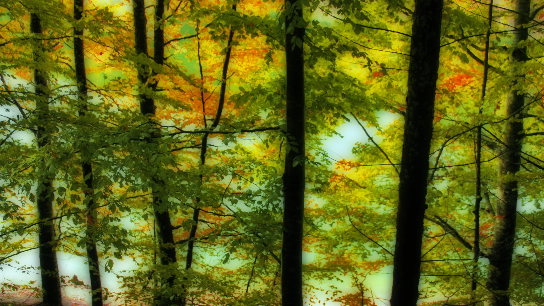
You come to the Irati Forest for silence, shade, and a feeling of being small beneath ancient trees. Set in the western Pyrenees between Spain (Navarre) and France (Lower Navarre/Soule), this beech–fir woodland covers roughly 17,000 hectares, making it one of Europe’s largest and best-preserved of its kind. Walkers, photographers, and families love its easy-to-follow trails, calm reservoir shores, and autumn palettes that turn the hills copper and gold.
A thin thread of birdsong carries through the beech canopy like water over stone. You will find this guide focused on what helps you plan with confidence: essential facts, how to get there, a season-by-season overview, signature Irati Forest trails with a downloadable map (PDF/KML), practical safety and gear tips, and places to stay in nearby villages such as Ochagavía, Isaba, and Orbaizeta. We keep jargon simple and define terms as we go, so “PR” (short-distance path) and “GR” (long-distance path) won’t slow your planning down.
You can expect clear distances, rough driving times, and straightforward advice about parking and visitor regulations. Families get gentle loops under the beech canopy; hikers find panoramic ridgelines and longer days out; photographers get the best light and vantage points. As you move through Irati, remember this is living countryside: shepherds, foresters, and small hotels keep traditions alive, and your visit helps sustain them if you tread lightly and buy locally.
Use the Irati map we reference in each route section, download tracks to your phone, and check weather before you set out. If you prefer someone to lead, local guides offer seasonal hikes and wildlife outings, and you can combine them with stays in rural hotels or casas rurales. Take your time; Irati rewards slow travel with soft paths, filtered light, and a steady, grounding quiet that lingers long after you leave.
Picuco te puede ayudar
Does something here catch your eye?
Tell us.
Write to us on WhatsApp or email: we answer questions, find the best options and help you sort out the booking.
Essential Facts Before You Go
Start with the basics so you can fine-tune routes and timing to your trip. The Irati Forest spans the Spanish side in Navarre (Valleys of Aezkoa and Salazar) and the French side in Lower Navarre/Soule (Forêt d’Iraty), with elevations roughly 800–1,500 m and peaks nearby rising higher. On the Spanish side, the two classic gateways are Ochagavía/Izalzu (Casas de Irati area) and Orbaizeta (Irabia Reservoir), each with signed trailheads and seasonal parking control. On the French side, access commonly starts from the Iraty Chalets area above Mendive and Larrau.
A damp, earthy scent rises after rain along the wooden footbridges. Expect a temperate mountain climate: frequent rainfall year-round, cool summers, and snowy spells in winter at higher elevations. As a rule of thumb, plan for changeable weather and pack waterproof layers even in summer. Annual precipitation typically exceeds 1,200 mm in the central Pyrenees, and afternoon showers can sweep in quickly (consult AEMET for forecasts: aemet.es).
Visitor information and official references:
- Government of Navarre – Tourism (Selva de Irati overview and updates): visitnavarra.es
- Government of Navarre – Protected areas and regulations: navarra.es (Medio Ambiente / Espacios Naturales)
- Weather forecasts (Spanish Met Office): aemet.es
- French-side tourism (Pyrénées-Atlantiques): pyrenees-atlantiques-tourisme.com
Typical information center hours vary by season (often mid-morning and late afternoon in spring–autumn, reduced in winter). Always confirm current schedules on the official websites above or at the Ochagavía and Orbaizeta tourist offices before a weekend visit, especially in leaf-peeping season (October–early November). Many car parks operate seasonal attendants and barriers; small fees are common and help fund maintenance.
Key regulations and norms:
- Stay on marked trails to protect fragile understory plants and minimize erosion.
- Dogs must go on leash in sensitive fauna areas; check on-the-spot signage for seasonal rules (e.g., breeding season).
- Wild camping is not allowed; use official campsites or authorized accommodation. Bivouacs (single-night, low-impact overnights) are often restricted—confirm locally if in doubt.
- Fire is strictly prohibited except in designated areas; heed high fire-risk alerts in summer.
- Foraging (mushrooms, etc.) may require permits in certain municipalities; ask at local offices.
- Many forestry tracks are closed to private vehicles; do not move barriers, and respect “No Motor Vehicles” signs.
Road access is generally good to the main gates on paved roads, though narrow, winding stretches demand patience and slow speeds. Secondary tracks can be rough, seasonally muddy, and sometimes closed after storms or snow. Cell coverage is patchy once you leave the villages; download offline maps, tell someone your plan, and carry a basic first-aid kit.
Finally, treat Irati as a living landscape shared with local communities. Greet shepherds, yield to forestry vehicles at work, and consider traveling midweek or early morning on weekends to disperse pressure. Your timing and choices help keep Irati’s forest floor as undisturbed as it feels.
Getting There and Parking Made Simple
Reaching the Irati Forest is straightforward if you plan your route and timing around winding mountain roads. From Pamplona (Iruña), allow 1 h 45–2 h to reach Ochagavía/Izalzu via NA-150/NA-178 or around 1 h 45 to Orbaizeta via NA-135/NA-140, depending on traffic and stops. From San Sebastián/Donostia, estimate 2 h 30–2 h 50 via A-15 and NA-178/NA-140. From Huesca or Jaca (Aragonese Pyrenees), plan 3–3 h 30 across the Canfranc corridor and NA-140 via Isaba; mountain passes can slow travel in winter.
The beech trunks appear like a colonnade in your windshield’s frame as the last bends open. Public transport works if you build in flexibility: regional buses run from Pamplona to Ochagavía and Isaba on select days and hours (not always daily, and reduced on weekends). Trains connect to Pamplona and San Sebastián; from there, transfer to regional buses or rent a car for final access. Confirm current timetables through the Navarre tourism portal (visitnavarra.es) or local bus operators noted there.
Main access points and car parks (Spanish side):
- Ochagavía/Izalzu – Casas de Irati area: Paved approach; large seasonal car park; attendants on busy days. Gentle family routes start here and signage is abundant.
- Orbaizeta – Irabia Reservoir/Arrazola area: Paved then improved gravel for final stretch; several small car parks near trailheads. Easy reservoir circuits and lakeshore viewpoints.
- Irabia dam (Presa de Irabia): Limited spaces; arrive early. Good for the reservoir loop but can fill quickly on autumn weekends.
Expect seasonal fees of roughly 3–6 € per car at the main gates; bring cash or card and confirm on arrival. Peak congestion occurs 10:30–14:00 on October weekends and holiday periods; early arrivals (before 09:00) or late-afternoon hikes (after 15:30) avoid queues and give softer light for photography. On the French side, the Iraty Chalets area provides ample parking and trail access but follows similar seasonal rules and fees; check onsite boards.
Tips for smooth mobility:
- Carpool from your lodging to reduce parking pressure.
- If a lot is full, follow staff directions to overflow areas rather than shoulder parking.
- In wet spells, expect muddy verges and drive more slowly on the last gravel sections.
- After storms or snow, check closures on visitnavarra.es and heed temporary barriers on forestry tracks.
- Carry a printed overview map as backup; GPS works erratically under thick canopy.
A simple table helps you choose where to point your wheels:
| Access & parking | Approach road | Surface (last km) | Indicative fee | Best for | Notes |
|---|---|---|---|---|---|
| Casas de Irati (Izalzu) | NA-140 via Ochagavía | Paved | 3–6 € | Families, easy loops, signage | Fills mid-mornings in Oct |
| Orbaizeta–Irabia (Arrazola) | NA-140 via Garralda | Good gravel | 3–6 € | Reservoir loop, shady trails | Several small lots; arrive early |
| Presa de Irabia | Spur from Arrazola | Mixed | 0–3 € | Quick lakeside access | Limited spaces, tight turnarounds |
When to Go: Seasons, Weather, and the Irati Autumn Colors
Choosing the best time to visit Irati depends on your goals—flowers, cool summer shade, or the famous autumn colors. Spring (April–June) offers bright green leaves, wildflowers in clearings, and variable weather with showers; temperatures usually range 5–15°C at 900–1,200 m, rising on sunny days but cooling quickly in the shade. Trails are generally open by May, though snow can linger on high ridges and muddy sections are common on flat beech paths.
A faint smell of wet leaf-litter lifts as you brush a mossed trunk with your sleeve. Summer (July–August) brings long days, stable weather spells, and comfortable hiking under the canopy; expect 12–24°C at mid-elevations, with cooler mornings and occasional afternoon thunderstorms. Families enjoy reservoir-side picnics and short loops with consistent shade, while photographers chase dappled light on trunks at golden hour. Start early to secure parking and carry more water than you think you need.
Autumn (late September–early November) is peak season for color. The “Irati autumn colors” usually crest between mid-October and early November, varying by elevation and the year’s rainfall and cooling patterns. Higher ridges turn first; valley floors glow later. Weekends can be busy, so consider midweek visits or sunrise starts. Photographers find the richest tones after light rain, when leaves darken and contrast snaps; hikers enjoy crunchy paths and clear air. Dress in layers and pack a small towel to wipe lenses and glasses after misty spells.
Winter (December–March) is quiet, short-day hiking at its simplest—or a snow day if conditions allow. Snow often settles above 1,000–1,200 m; lower-elevation loops may remain hikeable with care. Expect closures of secondary tracks, icy patches in the shade, and temperatures often below freezing in the mornings. If venturing higher, carry microspikes or light crampons, warm layers, and a headlamp, and reassess plans if wind or ice ramp up risk.
Seasonal gear snapshots:
- Spring: Waterproof shell, gaiters for mud, trekking poles for slippery descents.
- Summer: Sun cap, 2 L water per person, insect repellent, light rain jacket for storms.
- Autumn: Warm mid-layer, waterproof boots, microfiber cloth for optics, spare dry socks.
- Winter: Insulated jacket, microspikes, warm hat/gloves, map-and-compass backup and a thermos.
If your priority is color, target mid-October and keep plans flexible; watch forecasts from AEMET (aemet.es) and recent visitor photos on official channels (visitnavarra.es) to fine-tune the week you go.
Signature Trails and the Downloadable Irati Map
Irati’s path network lets you choose easy forest loops, reservoir-side strolls, or ridge walks with sweeping Pyrenean views. The downloadable Irati map (PDF/KML/GPX) indicated throughout this section helps you navigate offline: save it to your phone and open it in apps like IGN Spain, Gaia GPS, or maps.me. You will see the GR-11 (long-distance Pyrenees trail) intersecting near Belagua and several local paths marked as PR (short-distance) or SL (local) routes.
A cool hush greets you as the trail leaves the track and the canopy closes overhead. To use the map, zoom to your chosen trailhead (Casas de Irati, Orbaizeta–Irabia, or Belagua), select the route layer, and tap “Download” to store the PDF and KML/GPX for offline use. Mark turnaround times if hiking with children, and remember: distances feel longer on soft, leaf-covered ground.
Beech Forest Short Loop: a first taste of Irati for all ages
Start your Irati Forest experience with a 3–5 km circular under towering beech (and occasional fir) near the Casas de Irati entrance by Izalzu/Ochagavía. Plan 1–2 hours with minimal elevation gain (under 150 m), wide paths, and steady shade that suits families and first-time visitors discovering “rutas Selva de Irati” at a gentle pace. Waymarks are frequent, junctions are clear, and benches appear near small clearings where you can rest.
Sunlight flickers like coins through the leaves as you step over roots and soft moss. Photographers get classic beech columns and soft ground textures; try shooting low at f/4–f/5.6 to blur the forest floor. After rain, expect muddy patches; waterproof boots and a small towel help keep the day comfortable. Keep kids close at short narrow sections where the path edges a stream gully or skirts a rooty slope.
Practical pointers:
- Start early to secure parking at Casas de Irati and enjoy quieter paths.
- Load the loop track from the Irati map into your phone; enable airplane mode to save battery.
- Bring snacks—walking with children is smoother with small incentives and mini-goals.
This loop makes “Selva de Irati” feel intimate and sets you up for longer Irati Forest trails later in the day or trip.
Irabia Reservoir Circuit: easy walking with water views
This gently undulating path circles or partially follows the Irabia Reservoir, offering 9–12 km of easy-to-moderate hiking (2.5–3.5 h) with minimal navigation challenges. Access works best from the Orbaizeta side (Arrazola area) or the Irabia dam spur; both appear in the downloadable “Irati map” layer, where you can select the full loop or a shorter out-and-back along the shore.
A soft ripple laps against the shore while a grey heron lifts from the shallows. Picnic benches and grassy patches appear near inlets; birdlife includes herons, dippers, and various forest-edge species boosted by the water’s edge. Expect shade on much of the route, with occasional clearings and small bridges; after prolonged rain, puddles and slick leaves can make footing tricky.
Practical pointers:
- Counterclockwise often gives steadier gradients if doing the full circuit.
- Avoid shoreline shortcuts that cut through fragile vegetation; stick to the signed path.
- Families can opt for a 4–6 km lakeside out-and-back from the dam if the full loop feels long.
Use the “Irabia Reservoir” overlay on the Irati map to pick your start and view estimated times and elevation profile before you go.
High ground toward Mesa de los Tres Reyes: moderate ridge views
If you want bigger views without committing to a full summit day, choose a moderate high-country route that samples the Larra–Belagua ridges with 500–700 m cumulative ascent over 10–14 km (4–6 h). A popular option follows a section of the GR-11 and local paths from the Belagua sector toward the Collado de Petrachema, with grandstand views of the karstic Larra plateau and, on clear days, the 2,448 m Mesa de los Tres Reyes.
Wind combs the grass along the ridge as ravens tumble in the updraft. This is “senderismo Selva de Irati” in its broader sense—the high zones that frame the Irati basin. Carry a windproof layer, map/GPX, and enough water; springs can be seasonal. Early morning or late afternoon gives sculpted light on limestone and fir-crested slopes. In late spring, snow may linger on shaded traverses; in winter, treat this as an alpine route requiring crampons and experience.
Practical pointers:
- Mark a turn-around time so you don’t descend in the dark.
- Favor grippy soles; limestone karst can be slick when wet.
- If you’re new to higher terrain, consider a guided outing; local guides know routes that fit the day’s conditions.
Find this route under “Belagua high ridges” in the Irati map download, with a safer shoulder-season option along the Abodi ridge above Irati (400–600 m ascent; big views, less exposure).
Senda de los Miradores (belagua): panoramas for photographers
Designed with viewpoints in mind, the Senda de los Miradores is a 6–8 km circuit (200–300 m ascent) on good paths above the Belagua valley, balancing effort and reward with layered vistas and wildlife chances. You’ll move through open clearings and fir-beech edges, stopping at named miradores marked on the downloadable Irati map; sunrise and the last two hours before sunset deliver the longest shadows and warmest tones for landscape shots.
Far below, the valley breathes mist like steam from a low kettle. Watch for lammergeiers and griffon vultures riding thermals, and in quieter hours, chamois crossing pale limestone ledges. Bring a mid-range zoom (24–70 mm) for landscapes and a telephoto (200–300 mm) for wildlife; a light polarizer can tame glare off bright rock. Please keep a respectful distance from animals and avoid cliff edges in windy conditions.
Practical pointers:
- If time is short, walk directly to one or two key miradores marked on the map.
- In summer, carry extra water; open sections get hot even at altitude.
- Combine with a shorter forest loop back in Irati to enjoy both canopy light and long views in one day.
Use the “Miradores – Belagua” overlay on the Irati map to locate parking and each viewpoint, then load the GPX to your preferred app.
Activities and Highlights: Hiking, Photography, Wildlife, and Flora
Irati is more than a walk in the woods: guides lead dawn wildlife outings, photographers chase fog layers, and families collect moss textures and leaf shapes as living souvenirs. The forest’s backbone is beech and fir, dressed with lichens that testify to clean air; edges and meadows bring butterflies, orchids in spring, and browsing deer at dusk. You can shape a day that fits the people you’re with and the light you find.
A robin’s note hangs in the still air like a bead on a wire. Choose from self-guided hiking, guided interpretive walks, wildlife observation from discreet vantage points, and simple picnics near water. The key is timing: early and late hours turn the forest into a softbox; midday suits interpretive stops and family play on clearings. Buy snacks and packed lunches in the villages; your euros help keep small bakeries and shops alive through the seasons.
Hiking: levels, waymarking, and safety
Pick routes to match fitness and daylight. Short family loops (3–5 km) sit near Casas de Irati and the Irabia shore; moderate ridge options (10–14 km) touch Belagua and Abodi; long, committed days combine several segments for 18–25 km. Waymarking uses color stripes on posts and trees: GR (red/white) for long-distance routes like GR-11, PR (yellow/white) for short-distance loops, and SL (green/white) for local paths.
Beech leaves whisper underfoot as you follow a yellow flash on a trailpost. For “senderismo Selva de Irati,” carry a paper map or loaded GPX, check the forecast, and set a turnaround time. Apps like IGN Mapas (Spain), Gaia GPS, and maps.me work offline if you download areas in advance. Tell someone your plan, and in shoulder seasons add a warm layer—you can cool fast under shade and wind.
Photography: key spots and the best light
Forest interiors love soft light: overcast mornings, misty hours, and the hour after sunrise. Point lenses along tree corridors, shoot low through ferns, and bracket exposures to capture dynamic range. On ridges and miradores, late afternoon carves limestone in relief; in autumn, polarized light after rain makes gold beech glow.
Fog threads through trunks, muting sound like a natural studio. Pack a 24–70 mm for forest scenes, a 70–200 mm for wildlife and compressed layers, and a small tripod for low ISO in dim light. Use a circular polarizer lightly to tame glare; too much can darken wet leaves unnaturally. Respect animals: keep distance (30–50 m minimum for deer), avoid sudden moves, and never bait or call wildlife. Stay on trail edges to protect mosses and seedlings.
Wildlife and flora: emblem species and where to see them
Irati’s emblem trees are beech (Fagus sylvatica) and silver fir (Abies alba), with oak and birch mixing at edges. Lichens drape branches like grey-green lace, a sign of clean mountain air. Among mammals, roe deer and red deer browse at dawn and dusk; you may hear stags during the rut (late September–October). Birds include dippers on streams, woodpeckers in mature stands, and high-soaring vultures near Belagua.
A sudden crack of a branch sends a deer bounding like a spring over leaf-duff. Best observation windows:
- Deer: Dawn/dusk along forest–meadow edges, especially in early autumn rut.
- Birds: Along the Irabia shore and stream crossings, mid-morning calm.
- Raptors and chamois: Belagua cliffs and ridges in stable weather.
Watch quietly, avoid playback audio, and keep pets leashed around wildlife. Binoculars (8x–10x) and patience beat closeness every time.
Family-friendly activities and easy alternatives
Keep family days simple: short loops at Casas de Irati, shoreline walks along Irabia, and picnic stops with logs to balance on and leaves to collect. Stroller-friendly stretches exist near the reservoir and some forest tracks close to the main gates; ask onsite staff which segments currently suit wheels. For kids on bikes, choose wide, gently graded tracks near the entrances rather than singletrack.
The smell of pine sap lingers on a sunny bench where you unwrap sandwiches. Visit interpretation centers for displays on forest life, and mix walking with a cafe stop in Ochagavía or Orbaizeta. Target 60–90 minutes of walking for under-7s with snack-and-play breaks, and pack light: water, a shared jacket, and a small first-aid kit. In cool seasons, add a thermos of hot chocolate for morale and warmth.
Where to Stay: Villages and Rural Bases Around Irati
Staying near the forest gates gives you calmer starts and softer evening walks after day-trippers leave. Ochagavía (Otsagabia) anchors the Salazar valley with stone houses, a small river, and access to Casas de Irati; Orbaizeta and the Aezkoa valley bring you close to Irabia Reservoir and quieter woods. Isaba (Izaba) and the Belagua sector suit ridge days and miradores, with quick drives to high trailheads.
A hearth’s woodsmoke drifts through cool evening air as voices carry from a village bar. Accommodation types span rural hotels, casas rurales (country homes, often owner-run), small hostels, and family-friendly campsites. You’ll eat Navarrese mountain fare—soups, local cheese, chistorra, and cuajada—woven into simple, generous menus. Booking two nights or more lets you alternate a forest loop, a reservoir stroll, and a ridge view without rushing.
Advantages by base:
- Ochagavía/Izalzu: Best for families and first-timers; fastest to Casas de Irati and short loops.
- Orbaizeta/Aezkoa valley: Quiet access to Irabia; good for wildlife dawn/dusk sessions.
- Isaba/Belagua: Quick to high miradores and
GR-11segments; pair views with one forest day.
Booking tips:
- Autumn weekends (mid-Oct–early Nov) sell out weeks in advance; reserve early and consider midweek stays.
- Check for breakfast times that match your start; early coffee matters on sunrise days.
- Ask hosts about current track conditions, snow lines, and recommended parking for the day’s plan.
- If traveling with kids, confirm room setups (cot availability, connecting rooms) and nearby picnic spots.
By sleeping locally, your spend supports small family businesses that maintain buildings, trailside fences, and the slow routines that make Irati feel lived-in rather than stage-set. Keep evenings simple: a stroll by the river, a warm plate, and tomorrow’s map on the table.
Practical Tips: Safety, Gear, and Moving Responsibly
A little preparation goes far in Irati’s changeable mountain weather and shaded paths. Think layers, navigation backups, and habits that keep both you and the forest in good shape. If you’re new to mountain hiking, start with shorter loops, build comfort, and only then step onto a ridge route. Most mishaps here come from slips on wet leaves, surprise weather changes, or late starts that chase darkness.
A tiny breeze lifts damp leaves like pages turning. Pack smart by season:
- Spring: Waterproof jacket, light fleece, gaiters for mud, trekking poles.
- Summer: Sun cap, 2 L water per person, snacks, compact rain shell.
- Autumn: Warm layer, waterproof boots, spare socks, small towel for optics, headlamp.
- Winter: Insulated jacket, microspikes, hat/gloves, thermos, spare batteries.
Mountain safety basics:
- Check AEMET (aemet.es) and local updates on visitnavarra.es before you go.
- Download offline maps and carry a paper overview; batteries drain fast in the cold.
- Tell someone your plan and set a turnaround time; daylight is precious in winter.
- On slippery slopes, shorten strides and use poles for three-point contact.
Responsible behavior (“leave no trace” in plain terms):
- Stay on paths; cutting corners erodes soil and damages roots.
- Pack out all waste; tissues and fruit peels belong in your bag, not the woods.
- Keep dogs leashed in wildlife zones; spring breeding season is especially sensitive.
- Do not pick flowers or collect lichens; admire, photograph, leave for the next pair of eyes.
Navigation and signage:
GRred/white = long-distance;PRyellow/white = short routes;SLgreen/white = local.- Junction posts often show times as well as distances; use them to reassess plans with kids.
- Expect spotty mobile signal; do not rely on constant phone service under dense canopy.
Pets and family travel:
- Bring a collapsible water bowl and extra water for dogs; streams can run low late summer.
- Check accommodation pet policies in advance; some charge cleaning fees.
- With children, pack a warm spare layer and mitts even in shoulder seasons; forest shade runs cooler than open valleys.
Travel light, tread soft, and give a kind word to trail staff and locals; it all cycles back into a healthier Irati.
Frequently Asked Questions
What is the best time to visit the Irati Forest?
The “best” window depends on your goal. For color, the Irati autumn colors tend to peak mid-October to early November, with higher ridges turning first and valley floors last; expect busy weekends and book lodging early. Spring (April–June) brings fresh greens, flowers in clearings, and changeable weather—great for photographers who like soft light and walkers who don’t mind damp paths. Summer (July–August) offers stable spells, long days, and cool forest shade for families, though midday can be warm and busy near car parks. Winter is quiet and short on daylight; low loops can work in settled spells, but high ridges need winter gear and experience. If your plan is flexible, monitor AEMET forecasts and recent updates on visitnavarra.es the week before you go to pinpoint your best light and access.
How do I get there and where do I Park in high season?
From Pamplona, allow around 1 h 45–2 h to reach either Ochagavía/Izalzu (Casas de Irati) or Orbaizeta (Irabia); from San Sebastián, 2 h 30–2 h 50; from the Aragonese side, 3–3 h 30 via Isaba and Belagua. In high season and on peak-color weekends, arrive before 09:00 or after 15:30 to avoid queues. If your chosen lot is full, staff will direct you to overflow areas—please do not park on verges that damage roots or block farm access. For a clear overview, use the downloadable “Irati map” on this page: zoom to Casas de Irati, Orbaizeta–Irabia, or Belagua to see car park icons and route starts. Public transport can help on weekdays: buses connect Pamplona to Ochagavía/Isaba on select schedules; confirm current timetables through visitnavarra.es and match arrivals to short loops rather than full-day routes.
Do I need a special permit, and are there restrictions on driving tracks?
You do not need a hiking permit for standard marked trails, but seasonal parking fees at main gates are common and help fund maintenance. Forestry tracks are often closed to private vehicles; respect barriers and “No Motor Vehicles” signs at all times. Wild camping is not allowed; use official campsites or lodging, and check whether any bivouac rules apply in neighboring high-mountain zones. Dogs must be leashed near wildlife and livestock; in nesting or rutting seasons, certain areas may post stricter rules—follow onsite signage. Fire is prohibited outside designated areas. For foraging (e.g., mushrooms), municipal permits may be required; inquire locally. Check updates and temporary closures on visitnavarra.es (tourism) and navarra.es (environment/protected areas) before you travel.
What basic gear do I need for the most common routes?
Keep it simple and season-aware. For “senderismo Selva de Irati” on family and moderate trails, carry:
- Footwear: Waterproof hiking shoes/boots with good grip, especially in autumn/spring mud.
- Clothing: Layered system—base, mid, and waterproof shell; add an insulated layer in winter.
- Navigation: Offline map on your phone plus a paper overview; a small power bank helps.
- Safety: Headlamp, basic first-aid kit, whistle, and emergency blanket (light and cheap).
- Hydration/food: 1.5–2 L water per adult in summer; snacks or a light picnic.
- Extras: Trekking poles for slippery leaves, microfiber cloth for lenses/glasses, sun cap and sunscreen in summer, gloves/hat in winter.
Apps like IGN Mapas (Spain), Gaia GPS, and maps.me handle offline GPX well. Load the Irati map you download from this page and select your route layer before you lose signal.
Book your experience — discover trusted outdoor activities across Spain with Picuco’s verified providers.
Conclusion
Irati rewards unhurried travelers with cathedral-like beech–fir shade, quiet water at Irabia, and ridges that throw the Pyrenees into relief. You now know how to get there, where to park, and when to time your trip: spring’s fresh green, summer’s stable shade, autumn’s famous gold, and winter’s silent breaks. Families can start with the Beech Forest Short Loop and a lakeside stroll; hikers can step higher toward Belagua ridges or along Abodi for big-sky light without committing to a full summit day.
A single jay calls once, and the forest settles back into itself. Bring layers, loaded offline maps, and a responsible mindset: stay on marked trails, leash dogs around wildlife and livestock, and pack out everything. If color is your goal, watch forecasts and plan midweek; if calm is your goal, go early or late in the day. Support local villages—sleep close, eat nearby, and ask hosts about current conditions—so your trip feeds back into the place you came for.
Use the downloadable Irati map mentioned in each route, and save the KML/GPX before you disconnect. Whether you arrive with kids chasing leaf piles or a camera tucked under your jacket, Irati will meet you at your pace, whispering in beech and fir that this is a forest best walked softly and shared well.