Megaliths, Nature, and the Quiet Mystery
Megaliths pull us into the open like campfires in a dark valley. Across Spain, dolmens and menhirs rise from oaks, heaths, and badlands, inviting both contemplation and a day outdoors. If you search “dolmens Spain,” you’ll find a living map of trails, viewpoints, and ancient craft layered into today’s rural life. The draw is double: deep time and a present-tense landscape you can walk, smell, and feel. In one morning you can learn how people moved stones the size of vans, then spend the afternoon birdwatching in a protected dehesa.
This guide brings together ten megalithic routes between nature and mystery. It is for travelers who want to plan grounded escapes and for readers who study megaliths and need trustworthy context. You’ll find essential facts, visiting logistics, seasonal advice, and ideas for hiking, stargazing, and photography. A faint scent of thyme often rides the wind at these sites. We also emphasize responsible visits, acknowledging the communities who maintain footpaths, open visitor centers, and keep traditions alive.
Stones and landscape in dialogue
Megaliths sit where landforms speak: beside a rock face, on a ridge, or above a water source. In Iberia they appear from the Atlantic coast to Mediterranean sierras, often where pastures meet forest edge. Builders chose places that offered visibility and meaning—sometimes framing a sunrise, sometimes marking routes through valleys. At a dawn solstice in Antequera, light threads the Dolmen of Viera like a needle through cloth. In Huelva, the Dolmen de Soto—dated roughly 3000–2500 BCE—aligns toward the east, echoing cycles of life and light noted by archaeologists.
That blend of orientation, geology, and ritual still feels charged under open sky. The stones weather, yet their placement remains purposeful against lines of hills and windbreaks of cork oak. A lark’s call lifts over low scrub at midday. In this geography, heritage isn’t an indoor exhibit; it’s embedded in footpaths, farm tracks, and the cadence of rural work. Visiting means entering a shared space—past and present set in the same light.
What you will learn here
- Essential definitions: what dolmens and menhirs are, when they were built, and how.
- Ten detailed megalithic routes in Spain with access notes and visit times.
- Practical planning: best seasons, how to get there, and where to stay near clusters.
- Activities to enrich your trip: short hikes, dark-sky stargazing, and respectful photography.
- Conservation basics and permits: drones, protected landscapes, and site etiquette.
You can plan a weekend loop or a weeklong circuit pairing stone architecture with villages, markets, and small museums. The smell of wood smoke at dusk can be your day’s quiet punctuation. Use this as a field-ready companion: concise, specific, and rooted in the land.
Picuco te puede ayudar
Does something here catch your eye?
Tell us.
Write to us on WhatsApp or email: we answer questions, find the best options and help you sort out the booking.
What Dolmens and Menhirs Are: A Clear Archaeological Context
Start with two simple definitions. A dolmen is a stone-built chamber—typically a set of big upright slabs (orthostats) supporting one or more capstones—originally covered by a mound of earth or smaller stones. When you see only the stone chamber today, remember it once lay inside a tumulus (in Galicia often called a mámoa). A menhir, by contrast, is a single standing stone set upright, sometimes alone in a field, sometimes gathered in circles (cromlechs) or lines. Think of a dolmen as built space and a menhir as a marker.
Chronology anchors us. Most Iberian megaliths date to the Late Neolithic and Copper Age (roughly 3500–2000 BCE), with local variation. Radiocarbon sequences place many chambered tombs—the classic dolmens—around 3300–2600 BCE, while tholos-type tombs (beehive-like chambers with corbelled roofs) may trend later within the same broad window. Functionally, dolmens served as collective burial spaces and ritual foci, where communities returned for deposits and ceremonies over generations. Menhirs could mark territories, sightlines, or ceremonial grounds; their exact functions remain debated, and that open question is part of the fascination.
Construction techniques reveal practical genius. Builders quarried or selected local stone—limestone near Antequera, slate and granite in the west and northwest, sandstone in Huelva—and moved blocks using leverage: rollers, sledges, earthen ramps, and rope. To stand an orthostat, you dig a pit, tilt the base in, pack with small stones, and backfill. To raise a capstone, you build a ramp of earth and debris, slide it up, and later remove the ramp. These are simple machines applied at landscape scale. You can still feel the geometry by tracing the seams and fulcrums with your eyes. A cool draft sometimes seeps from the chamber on hot days.
Orientation matters across regions. Many Iberian dolmens align roughly east, welcoming first light into the passage. Some are astronomically precise: the Dolmen of Viera captures the equinoctial sunrise along its corridor; in Huelva, studies of Dolmen de Soto note an east-southeast bias consistent with solar events; and in tholos tombs like El Romeral (Antequera), alignments consider both topography and sightlines to landmarks. Antequera is a keystone example: the Dolmen of Menga, one of Europe’s largest, points not to the sun but to the face-shaped Peña de los Enamorados—tying architecture to a mountain’s human profile. UNESCO inscribed the “Antequera Dolmens Site” in 2016 for this unique triad of tombs and landscape monuments.
Diversity is visible on a map of dolmens Spain. In the south and southwest—Huelva, Cádiz, Málaga, and Extremadura—limestone and sandstone chambers can reach impressive sizes, with passages (corridors) leading to polygonal or rectangular rooms, sometimes with side niches. In Extremadura, the Dolmen de Lácara exemplifies a monumental corridor tomb, with a long passage (over 20 meters) guiding you to a circular chamber. Move northwest into Galicia and northern Portugal, and you’ll find mámoas—earthen mounds with granite orthostats—set on ridges and heathland, such as Dombate and Axeitos, where the mound is integral to the architecture. In the Catalan prelittoral and Pyrenees, menhirs and small dolmens dot ridgelines and oak forest, and stone circles (cromlechs) appear in upland pastures across Navarre and the Basque Country as harrespil—low rings with central cists—dating in some cases to later prehistoric periods.
Archaeologically, grave goods—ceramics, polished stone axes, beads, later copper items—speak to communities networked across landscapes. In Dolmen de Soto, engravings and anthropomorphic motifs enrich the narrative with a local symbolic language. In Antequera, massive slabs, interior pillars, and corbelled roofs demonstrate technical decisions calibrated to local rock. When you crouch at a passage mouth, the quiet is both architectural and environmental, and a breeze carries thyme and stone dust.
Why These Routes Are Worth Your Time: Culture in Open Air
Visiting megalithic routes is a way to touch deep prehistory without leaving the countryside. You step into a built space where ceremony happened, then step back into a living landscape where farmers prune olives and shepherds move flocks. The silence at a chamber doorway has its own acoustic; a hoopoe’s call can echo off a capstone like a soft drumbeat. That contrast—ancient architecture in everyday nature—is rare and remarkably accessible across Spain.
Culturally, these are protected assets with real research value. You engage with sites recognized by autonomous communities and, in some cases, by UNESCO. Antequera’s inscription (2016) sets a global benchmark for the dialogue between stones and mountain; Gorafe’s park catalogs hundreds of structures mapped and signposted; and Valencia de Alcántara’s dolmen fields are a reference in Extremadura archaeology. Small local museums and interpretation centers make context tangible: how a passage is built, why an axis points to a solstice, what a “mámoa” means. Ask locally—municipal offices and visitor centers often know seasonal access, road work, or maintenance closures.
For travelers, the experience layers easily with rural tourism. A dolmen stop fits between a morning market and a late-afternoon viewpoint. Trails are short and readable—kids can handle many within an hour—yet they lead to places that prompt questions and awe. Bring a simple field notebook for sketches and notes; jot down how light moves in a passage at different hours and what plants grow at the mound edge. The scent of cistus after a light rain can be surprisingly strong.
If you photograph, these sites teach light. Low sun defines textures on uprights and cap edges; backlight can make grass glow around a mound. At night, rural dark skies—extensive in Andalusia’s interior, Extremadura, and parts of Aragón and Castilla—invite stargazing. Many alignments cue you to look for horizon points and seasonal stars; astronomy apps can turn a quiet field into an open-air planetarium. Keep night visits safe and permitted; some sites close at dusk or sit within protected areas with restrictions.
Economically, respectful visits support small-town cafes, rural lodgings, and local guides who interpret both archaeology and ecology. Conservation flows from that relationship: when visits are careful—no climbing, no graffiti, no fire—heritage retains its integrity. A breeze through the grasses is the only thing that should move. Think of these routes as shared spaces of learning, where your presence helps sustain the communities that care for them.
Plan Your Visit: Locations, Seasons, Getting There, and Where to Stay
Spain’s megalithic landscape is broad, but clusters make planning efficient. Huelva and Cádiz form a southwestern belt; Málaga’s Antequera stands as a world-class triad; Granada’s Gorafe spreads across badlands; Extremadura holds monumental corridor tombs inland; Galicia concentrates mámoas near the Atlantic; Catalonia and the Basque–Navarre uplands feature menhirs and cromlechs. You can design a long weekend around a single hub or string two hubs together with one scenic drive. A wren’s scratchy song often keeps you company on short approaches.
Think in terms of three building blocks: when to go, how to get there, and where to base yourself. Climate and farm calendars shape access and comfort; transport varies from motorway junctions to narrow farm lanes; and lodging ranges from village guesthouses to simple campgrounds near protected areas. Pair sites with short hikes, local food, and a museum hour during midday heat. The smell of fresh bread from a bar de pueblo can anchor your morning.
Best seasons and seasonal considerations
- Spring (March–May) and autumn (late September–November) are ideal across southern and western Spain: mild temperatures, green fields, and clear light. In spring, wildflowers edge mounds in Extremadura and Andalusia.
- Summer (June–August) brings heat in Huelva, Málaga, Granada, and Extremadura; visit at first light or late afternoon. In badlands like Gorafe, shade is scarce and ground radiates heat well past sunset.
- Winter (December–February) is pleasant in southern lowlands; inland plateaus can be cold and windy, and Galicia sees frequent rain. Pack a waterproof for Atlantic fronts.
- Photography and crowds: sunrise offers the cleanest light and the quietest experience; sunset can work well, but check closing times—some sites are gated after hours. Solstice and equinox days sometimes attract visitors hoping to catch alignments.
- Local calendars: harvests, hunting seasons, and village fiestas can affect access to farm tracks or create traffic on narrow roads. Ask at the municipal tourist office before you set out.
A thin frost can sparkle on capstones on winter mornings.
How to get there and transport options
- By car: Most clusters sit within 10–30 minutes of a main road. For Antequera, exit from
A-45and follow signs to Menga/Viera and El Romeral. For Gorafe, come viaA-92(Guadix) and local roads into the park. Dolmen de Soto lies near Trigueros offA-49(Huelva–Seville). - Public transport: Town hubs like Antequera, Huelva, and Cáceres have train or bus connections, but final approaches often require a taxi or a pre-booked transfer. Rural taxis are reliable if arranged ahead by phone through local dispatch.
- Car rental: Useful for linking multiple dolmens in a day. Choose compact vehicles for narrow lanes and park off verges to avoid damaging vegetation.
- Wayfinding: Signage is improving but can be patchy. Download offline maps, note
PRfootpath codes where posted, and carry a paper map for redundancy. - Itinerary links: From Antequera you can connect to El Torcal (protected karst); from Valencia de Alcántara you can loop to Sierra de San Pedro viewpoints; Gorafe pairs naturally with the Guadix–Baza Geopark routes.
- Parking: Use designated lay-bys or signed lots; never drive onto the mound apron. In wet weather, farm tracks can bog down—avoid ruts and turn around before it’s risky.
Dust rises softly from farm tracks in summer, and you’ll taste it in the air.
Where to sleep: rural stays for megalithic routes
Choose a base near a cluster to minimize backtracking:
- Village casas rurales and small hostales within 10–20 minutes of sites let you return for dawn or dusk light.
- Campgrounds near protected areas (e.g., Sierra de Aracena, Guadix–Baza) offer dark skies and early starts for hikes.
- Farm stays sometimes coordinate with local guides who run short interpretive walks; ask at check-in about seasonal access and any closures.
- In high season (Easter, summer weekends, local fiestas), book 2–4 weeks ahead. For shoulder seasons, midweek stays often bring quieter visits and better rates; confirm amenities like heating in stone buildings for winter trips.
- If you plan to cover several clusters—say, Antequera and Gorafe—split your nights: two nights per hub is a simple rhythm.
At night in the countryside, crickets can feel like a soft, steady tide.
What to Do There: Hiking, Stargazing, and Photography
A megalithic route is more than a checklist of chambers and standing stones. Treat each stop as a small outdoor classroom, then stretch your legs on a loop trail, look up at night, and bring back thoughtful images. A black kite’s shadow crossing a mound can be a lesson in composition. Activities here revolve around slow time—walking, watching, and adjusting to light.
Interpretive walks help you read stone, soil, and context. Night skies teach you to find horizons and ecliptic paths that mattered to builders. Photography asks you to balance respect for the site with creative angles that frame heritage in its landscape. You can layer in craft workshops or museum visits to break up driving. The smell of warm pine needles underfoot is its own invitation.
Hiking and interpretive routes
- Difficulty: Most approaches are easy (5–30 minutes one-way on farm tracks or short trails). A few, like upland cromlechs, require moderate hiking (200–500 m elevation gain).
- Signage: Parks like Gorafe and hubs such as Antequera and Valencia de Alcántara provide panels and waymarks; elsewhere, look for municipal signs at road junctions and pathheads.
- Duration: Plan 20–40 minutes per dolmen for approach, observation, and notes. Add time for photography or sketching. Combine 3–6 sites for a half day.
- Gear: Grippy shoes, hat, water, and a light jacket for wind-exposed ridges. A small headlamp helps explore interior light without touching stones; never use open flames.
- Itineraries: In Gorafe, signed loops connect multiple tombs across badlands; in Valencia de Alcántara, rural circuits link granite dolmens through cork oak. Seek local “rutas megalíticas” maps at tourist offices to stitch half-day itineraries.
A breeze can sound like a distant river in the cork oak canopy above a corridor tomb.
Stargazing and astronomical connections
- Why it fits: Many passages face sunrise points; that same attention to sky makes these landscapes great for night observation—low horizons, sparse lighting, and quiet fields.
- When to go: New moon weeks give the darkest skies; astronomical twilight ends roughly 60–90 minutes after sunset, depending on season. Winter air is often clearest; summer Milky Way arches bright in the south.
- What to use: Free apps (e.g., sky map tools) show positions of the sun, moon, and bright stars relative to the horizon; red-light headlamps preserve night vision; a compact binocular (8x42) reveals star clusters.
- Etiquette: Confirm site hours—many close at dusk. If night access is permitted, move quietly, avoid shining lights on stones, and keep groups small. Do not climb capstones for “astro” shots.
- Events: Solstice and equinox sunrises matter at sites like Viera; lunar standstills and meteor showers (Perseids in August, Geminids in December) can pair with nearby open viewpoints outside site perimeters.
On still nights, your breath will hang briefly in the beam of a red headlamp.
Photography and composition in megalithic landscapes
- Light: Work the first and last hour of sun for side-light texture; overcast days flatten contrast but reveal carved details and lichen color.
- Lenses: A wide-angle frames chamber and mound with sky; a short tele compresses ridges and aligns capstone edges with distant peaks. Move your feet rather than stepping on stones.
- Angles: Lower your camera to show cap thickness against horizon; step back to include a guiding oak or the outline of a landmark mountain (e.g., Peña de los Enamorados near Menga).
- Night shots: If permitted, keep exposures brief; avoid light painting that heats lichen or disturbs wildlife. High-ISO single exposures are safer than multi-minute trails.
- Respect: Tripods should stand off the mound edge; no drones without permits; no props touching stones. Professional crews may require heritage or park authorization—ask at the municipal office.
The grit of sandstone under your hand tells you all the texture you need to show in frame.
Ten Megalithic Routes: Stones, Trails, and Quiet Horizons
Below are ten curated itineraries spanning Andalusia, Extremadura, Galicia, Catalonia, and the Basque–Navarre uplands. Each entry covers what to see, how to reach it, how long to plan, and nearby bonuses. Treat time estimates as field pacing, not stopwatch targets. The smell of dry grass along farm verges will slow you happily.
1) Huelva: Dolmen de Soto and the Trigueros Landscape
The Dolmen de Soto, near Trigueros, is one of Iberia’s standout corridor tombs, dated broadly to the 3rd millennium BCE. Its long passage opens east-southeast, and interior engravings—anthropomorphic figures, zigzags—deepen its ritual language. Architecture here uses sandstone slabs and a gradual narrowing that pulls the eye toward the chamber. At midday, cool air lingers inside like a held breath.
Access is straightforward by car from A-49 (Huelva–Seville); exit toward Trigueros and follow municipal signs. The approach road is paved, with designated parking near the visitor area. Plan 45–60 minutes for the site: short approach, time inside, and a slow walk around the mound perimeter to read the chamber’s proportions. If the municipal schedule includes staff-led visits, join one; you’ll learn to spot engraved motifs you’d miss alone.
Practical notes:
- Check local opening times and any booking requirements with the Trigueros tourist office.
- Avoid stepping on the mound; stick to paths and the chamber floor.
- Combine with Huelva’s provincial megalithic contexts: the wider belt includes isolated dolmens on private and public lands—ask for mapped circuits at visitor centers.
- Nearby: Odiel Marshes Natural Area for birdwatching (spoonbills, ospreys in season), and rustic meals in Trigueros or San Juan del Puerto.
Golden light on the mound at dawn pulls a soft shadow line along the capstone.
2) Antequera (málaga): Menga, Viera, and El Romeral—a World-class Triad
Antequera’s trio is unlike anywhere: Menga and Viera (passage graves) sit beside town, while El Romeral (tholos) lies a short drive away. UNESCO inscribed the “Antequera Dolmens Site” in 2016 for the way these monuments converse with the Peña de los Enamorados and El Torcal karst. Menga is colossal—interior pillars hold its roof, and the axis points to the human profile of Peña. Viera’s corridor faces sunrise precisely, channeling equinox light; El Romeral’s corbelled dome is a masterclass in dry-stone engineering.
Arrive via A-45; Antequera has ample parking near the visitor complex for Menga/Viera, with foot access on paved paths. El Romeral is signposted on the town’s outskirts; allow 10 minutes by car and 30–40 minutes on site. Plan 2–3 hours to visit all three with reading time. Guided visits, when available through the site administration, enrich the context of alignments and construction techniques.
Tips for a smooth day:
- Start at Menga for scale, then Viera for orientation, finish at El Romeral for corbelling.
- Morning light works well for Menga’s facade and Viera’s corridor; El Romeral is flexible.
- Check seasonal hours; sites may close midday or at dusk.
- Nearby: El Torcal Natural Area (permit-controlled parking in high season), and town viewpoints for sunset over limestone waves.
As clouds move over Peña de los Enamorados, the profile on the horizon seems to breathe.
3) Gorafe (granada): A Park of 200+ Dolmens in Badlands
Gorafe’s megalithic park stretches across the Guadix–Baza basin, with over 200 cataloged dolmens spread on badland ridges and benches. Structures vary from simple cists to corridor tombs, all in a semi-arid setting of gullies and clay hoodoos. The sense of open space is vast; a kestrel rides thermals above eroded shelves like a kite on a string.
Base in Guadix or Gorafe village. From A-92, reach Gorafe via local roads; visitor panels and maps help you choose among signed loops and car-accessible stops. Many routes are on dirt tracks—passable in dry weather—so ask about conditions after rain. Plan at least half a day; a full day lets you pair two short loops with a siesta break. Sun exposure is total—spring and autumn are best, and summer demands early/late windows.
On the ground:
- Bring extra water, sun protection, and a hat; shade is rare.
- Use marked pullouts rather than verge parking; soil is fragile.
- Panoramas: High benches near certain dolmen groups offer 360º views; pick one for sunset and watch shadow lines climb eroded walls.
- Nearby: Guadix cave neighborhoods, and the UNESCO Global Geopark (Granada) interpretive routes for geology context.
At sunset, badlands shift from ochre to rose, and the dolmen slabs hold the day’s last warmth.
4) Cádiz: Alberite and the Villamartín Necropolis
Cádiz province holds a set of significant megaliths, with the Dolmen de Alberite in Villamartín among the best known. Alberite’s corridor and chamber, built in sandstone, date roughly to the 4th–3rd millennium BCE, and the site’s finds include beads and polished stone pieces. The broader Villamartín necropolis area preserves multiple tombs and traces of settlement. The air smells faintly of fennel in summer.
Access Villamartín via A-384 (Arcos–Antequera) and follow local signs to Alberite; parking is usually roadside with a short walk on a farm track. Some tombs lie on or near private land; respect fences and gates. Plan 60–90 minutes for the main dolmen and a circuit of nearby points as posted on municipal panels. The low, rolling landscape makes for easy walking and wide sightlines.
Good to know:
- Check with the local tourist office for current access and any guided visit schedules.
- Pair Alberite with other Cádiz megalithic or prehistoric sites mapped by municipalities; staff often provide leaflets outlining short “rutas rurales” that link archaeology and viewpoints.
- Nearby: Sierra de Grazalema Natural Park (trails under pinsapo firs) within an hour’s drive offers a stark ecological contrast to the lowlands.
Wind moving through dry grass here sounds like paper being turned.
5) Valencia de Alcántara (cáceres): Granite Dolmens and Rural Loops
West of Cáceres, near the Portuguese border, Valencia de Alcántara sits amid one of Extremadura’s richest megalithic landscapes—dozens of granite dolmens linked by rural lanes through cork oak and pasture. Chambers vary from simple polygonal rooms to long-passage monuments; the density allows rewarding half-day circuits. In spring, cistus and broom paint the verges white and yellow.
Reach town via EX-110 or EX-117 and check in at the municipal tourist office for maps of signposted routes—a practical gateway to “turismo rural megalítico.” By car, combine 4–6 dolmens with short walks (5–15 minutes each) to chambers set back from lanes. Plan 3–5 hours to avoid rushing; plan for a picnic under shade where permitted. A local guide, if available, adds ecological and historical notes that knit the route together.
Field pointers:
- Some tracks are rough; a compact SUV helps, but careful driving in a standard car usually suffices in dry weather.
- Early or late light rakes beautifully across granite textures; interiors stay cool even on warm days.
- Lodging: Casas rurales in and around Valencia de Alcántara make an excellent two-night base to cover multiple loops, with easy links toward Sierra de San Pedro for birding (Iberian imperial eagle habitat).
- Nearby: Portuguese border villages with granite architecture and slow rhythms.
Cork bark under your fingertips feels like charcoal corkboard—light, grooved, and warm.
6) Galicia: Mámoas and Atlantic Light
Galicia’s megaliths read differently: earthen mounds (mámoas) cover granite chambers on heaths, ridges, and forest edges near the Atlantic. Flagship sites like Dolmen de Dombate (Cabana de Bergantiños) and Dolmen de Axeitos (Ribeira) show classic forms and, in Dombate’s case, protective structures for conservation and interpretation. Atlantic clouds slide fast, and light pools in moss and lichen.
Approach from AP-9 or AG-55 depending on your base (A Coruña and Santiago are natural hubs). Many sites are close to paved roads; panels and short paths lead to chambers. Plan a half-day to visit 2–4 megaliths and include a small museum or interpretation center. Rain can be frequent—pack waterproofs and plan flexible timing, using cafe breaks in nearby villages.
Travel cadence:
- The term “mámoa” refers to the mound—respect the grassy dome; never climb or picnic on top.
- Low coastal hills offer viewpoints to pair with archaeology; choose a ridge walk for varied textures and wind-scoured light.
- Lodging: Village pensions and rural houses near the coast let you balance beach coves and megalith visits. Evenings can be fog-soft; bring a warm layer.
- Nearby: Atlantic lighthouses, petroglyph panels inland, and coastal paths with sea-thrift and heather.
Sea air mixes with the scent of wet granite after rain, earthy and sharp.
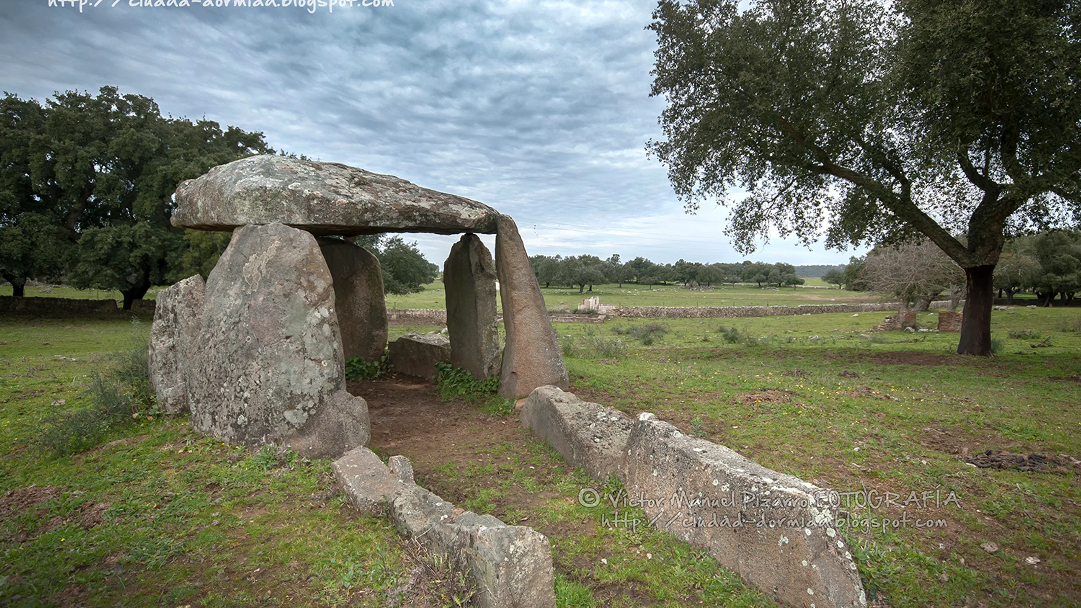
7) Inland Extremadura: Lácara and Monumental Corridor Tombs
Between Mérida and Aljucén, the Dolmen de Lácara stands as one of Extremadura’s monumental corridor tombs—long passage, large circular chamber, and robust granite orthostats. The corridor runs over 20 meters, creating a gradual, almost theatrical lead-in. In the wider region, additional megalithic sites—such as Magacela (a hilltop setting) and Huerta Montero (Zalamea de la Serena)—underline the interior’s diversity. A red kite often flickers over pasture here.
From Mérida, drive north toward Aljucén on N-630 and follow signs to Lácara; a short walk on a clear path leads to the site. Plan 45–60 minutes at Lácara to explore the passage and chamber and to sketch or photograph. Adding Magacela or other Badajoz sites makes a full-day loop; check distances and allow time for hill approaches.
On-site sense:
- Interiors can be damp; wear shoes with grip. Do not touch lichen-covered surfaces—health of these communities indicates stable microclimates.
- Heat in summer argues for early starts; winter days bring clear air and long shadows.
- Lodging: Base in Mérida or small villages north of town for quiet nights and short morning drives. Local guides sometimes coordinate multi-stop days mixing archaeology and birding in dehesa.
- Nearby: Mérida’s Roman heritage makes an illuminating historical counterpoint across millennia.
On winter mornings, breath steam lingers briefly at the chamber entrance.
8) Catalonia: Menhirs and Ridge Walks of the Prelittoral
In Catalonia’s prelittoral ranges—Montnegre i el Corredor, Serralada Litoral, and the Gavarres—menhirs and small dolmens dot ridgelines through oak, pine, and cork. Examples include the Menhir de Pedra Gentil (Vallgorguina) and scattered cromlechs or small cists near forest tracks. The scale is intimate: single uprights, modest chambers, and walks that weave archaeology into woodland. The resin scent from pines sharpens in warm light.
Access from Barcelona or Girona via C-32, AP-7, and local roads to park trailheads. Short hikes (30–90 minutes round-trip) lead to multiple stones; trails can be rocky with occasional steep pitches. Interpretive panels, where present, keep explanations concise—carry a map or app for junctions. Plan a half-day per park to combine two or three megalithic stops with a ridge viewpoint.
Field rhythm:
- Early weekend mornings are quiet; afternoons can be busier with local walkers.
- Winter offers clearer views; spring brings undergrowth—long trousers help.
- Combine with heritage farmhouses (masías) and small hermitages along trails; these layers tell a long land-use story.
- Lodging: Rural accommodations in Vallès, Maresme, or Baix Empordà make excellent staging posts; you can link beach coves or old towns in the same trip.
Under canopy, sunlight breaks into coin-sized patches across the menhir base.
9) Singular Menhirs and Cromlechs: Basque and Navarre Uplands
If you’re drawn to standing stones and stone circles, head for the Basque and Navarre mountains—Aralar, Aizkorri-Aratz, and Aiako Harria—where harrespil (small stone circles) and menhirs punctuate high pastures. Examples near Oianleku (Aiako Harria), stone circles in Aralar, and scattered menhirs across Aizkorri reward hikers with archaeology and views. Wind carries the tang of sheep and thyme along ridges.
Approach via Gipuzkoa and Navarre road networks (A-15, AP-8) to mountain park access points, then hike. Routes range from easy meadow loops (1–2 hours) to moderate ridge traverses (3–5 hours, 300–700 m ascent). Weather shifts quickly; carry layers and check forecasts. Panels are present at some sites, but a topographic map or GPS track is wise in fog.
Practical notes:
- Respect grazing; close gates and give flocks space.
- Snow or ice can linger in shaded gullies in winter; traction aids may be prudent.
- Circles are low—knee-high rings of stones—so train your eye to spot them in rough grass.
- Nearby: Sanctuary viewpoints and beech forests offer cool summer shade and luminous fall color.
Beech leaves shimmer like small mirrors in a gust, then settle with a hush.
10) Combined Itineraries: Megaliths and Protected Landscapes
Make the most of geography by pairing megalith hubs with protected areas:
- Antequera + El Torcal: Visit Menga, Viera, El Romeral, then hike Torcal’s karst loops (permit/parking controls in high season). The sculpted limestone offers otherworldly horizons.
- Gorafe + Guadix–Baza Geopark: Split days between dolmen loops and geology routes (badlands, fossil sites, and viewpoints). Hot, exposed conditions argue for dawn and dusk pacing.
- Huelva (Soto) + Odiel Marshes: Morning chamber visit, afternoon birdwatching on boardwalks and hides; migration seasons are rich.
- Valencia de Alcántara + Sierra de San Pedro: Dolmen circuits in cork oak, then raptor watching on dehesa ridges; finish with sunset at a granite viewpoint.
- Galicia (Dombate/Axeitos) + coastal paths: Mámoas in the morning, Atlantic promontories in the afternoon; fog can be a photographic asset.
Logistics:
- Check protected area rules: drone prohibitions, parking restrictions, and trail etiquette.
- Consider
GRandPRfootpath links (e.g.,PRloops near Gorafe) to stitch archaeology and nature. - Base yourself for two-night stays to reduce driving; this leaves room for weather pivots.
At dusk in El Torcal, goats move through karst corridors like a low bell choir.
Practical Advice: Safety, Conservation, and Permits
Treat megalithic sites as living heritage in living landscapes. Your visit should leave no trace. The single most important rule is simple: do not climb on stones or mounds. Capstones are heavy but vulnerable; micro-fractures, lichen, and packed soils degrade with weight. A fingertip touch to guide balance can be one thing; sitting on a capstone for a selfie is not. Wind moving through grass should be the only motion atop a mound.
Conservation basics:
- Stay on marked paths; avoid cutting across mounds or chamber roofs.
- Do not remove stones, pebbles, or artifacts; even “loose” pieces can be context.
- No fires and no candles inside chambers; soot and heat damage surfaces and microclimates.
- Keep voices low; part of the experience is acoustic—echoes can carry far.
Access and property:
- Some dolmens sit on or border private land; respect fences, close gates, and yield to farm operations. If a path crosses a pasture, move calmly and give livestock wide berth.
- Parking: Use designated spots; do not block farm tracks or emergency access. In wet weather, avoid churning verges.
Drones and photography:
- Unmanned aircraft often require authorization in heritage zones and protected natural areas under Spanish and EU rules (check current AESA guidelines and park regulations). When in doubt, do not fly.
- Professional photo/video shoots may require municipal or site-specific permits—ask at local tourist offices or heritage administrations.
Safety on trails:
- Summer heat in Andalusia and Extremadura is real; carry at least 1–2 liters of water per person and plan shade breaks. Start early.
- In mountain areas (Basque–Navarre), weather changes quickly; bring layers, a map, and a charged phone. Fog obscures low stone circles—watch footing.
- Headlamps beat phone torches for low-light exploration; avoid touching walls in narrow passages to protect surfaces.
Contacts and information:
- Municipal tourist offices and regional heritage portals publish updated hours and site advisories.
- Small local museums host temporary exhibits tied to excavations; ask about talks or guided walks.
The cool air inside a chamber on a hot day is a reminder: this architecture shaped climate as well as ritual.
Frequently Asked Questions
Is it legal to visit all dolmens and menhirs?
Many sites are public and signed, but others lie on private property or have restricted hours. Follow posted signs, respect closures or gates, and ask at the nearest municipal tourist office for confirmed access. When in doubt, do not cross fences without permission.
Do I need a guide or a permit?
You usually do not need a permit for a casual visit to signposted sites during open hours. Guided visits are strongly recommended at hubs like Antequera, Lácara, or Valencia de Alcántara because you’ll learn about orientation, construction, and conservation. Filming, drones, and professional shoots may require permits; check locally.
What can I touch or not touch?
Do not climb on stones or mounds, and avoid touching carved surfaces or lichen. If you need balance inside a chamber, rest a hand lightly on a stable, uncarved area. Never move loose stones or pick up artifacts; report any finds to local authorities.
When is the best time to go?
Spring and autumn offer the best weather and light across southern and western Spain. In summer, go at dawn or late afternoon to avoid heat; in Galicia, pack rain gear year-round. Check site hours—some close at dusk even in summer.
Are these routes family-friendly?
Yes, many dolmens sit a short, easy walk from a road, and kids generally enjoy the “stone house” vibe. Bring water, sun protection, and snacks; keep children off stones and mounds. For mountain cromlechs, choose shorter meadow loops and watch for quick weather changes.
Will I find information panels on site?
At major hubs like Antequera, Gorafe, and Valencia de Alcántara, expect good signage and sometimes small visitor centers. Elsewhere, panels can be minimal or absent—download offline maps and carry a short site note from a municipal leaflet.
Tip for first-timers
Start with a signed cluster (Antequera, Gorafe, or Valencia de Alcántara) to learn site etiquette and reading skills, then branch out to less-interpreted stones with confidence.
Respect during agricultural seasons
During harvests or when herds are moving, yield the right of way, keep dogs leashed or leave them home, and avoid blocking narrow lanes with parked cars.
Conclusion: Plan Your Megalithic Route With Care
You’ve just walked through 6,000 years of ingenuity embedded in open landscapes. Dolmens and menhirs are not only archaeological facts; they are invitations to move slowly, to notice light and wind, to meet communities that keep paths open and stories remembered. A morning at Menga or Lácara, an afternoon on a ridge above stone circles, and a dusk in badlands are a complete journey—history, ecology, and human craft in the same day. The smell of thyme on a warm rock will stay with you.
Plan your circuit with seasons and daylight in mind, pair stones with short hikes and simple meals, and keep conservation at the heart of every step. If you want to go deeper, ask locally for guided walks and small museum hours, and build in time for unhurried observation at each site. Responsible visits—no climbing, no drones without permits, no shortcuts across mounds—mean the stones endure for the next traveler and the next generation.
Use this guide as your field notebook: choose one hub, map a half-day loop, and let the land set your pace. When you return, you’ll bring back more than photos; you’ll carry a clearer sense of how people and places shape each other across long time.