Why Abandoned Places Still Speak
Empty streets and roofless walls can tell Spain’s most intimate stories. Abandoned places Spain draw photographers, hikers, and history lovers because they hold time still and invite us to look closely. A rusted hinge creaks in the breeze like a gate to the past. You’ll find ghost towns, archaeological ruins, and villages deliberately preserved as open-air classrooms, each with different rules and meanings.
You’ll read words like ghost town, historic ruin, and recovered village, so let’s keep them clear. A ghost town is a once-inhabited settlement now depopulated; historic ruins are structures—often churches, forts, or monasteries—left in partial remains; and recovered villages are abandoned places restored for education or cultural memory. Sunlight on broken tiles makes fine photographs, but the people who left—through war, migration, or expropriation—deserve your respect. This guide keeps both lenses open: the aesthetic and the human.
You can visit many of these sites safely with planning. Most sit close to roads, and a few require short walks or tracks. Dust rises from unpaved paths as swallows sweep low over stony lanes. We’ll cover when to go, how to reach them, and where to stay, along with legal basics like permits, hours, and property rights.
Below you’ll find ten historic ruins Spain has safeguarded or left standing as testimony, from Belchite’s Civil War scars to the silent monastery above the Duratón. Footsteps echo in empty naves like soft drumbeats. For each place, you’ll get concise history, what remains today, access tips, and safety pointers. Travel thoughtfully, carry out every crumb, and let the stories stay where they belong—on the wind, in the stones, and in your memory.
Picuco te puede ayudar
Does something here catch your eye?
Tell us.
Write to us on WhatsApp or email: we answer questions, find the best options and help you sort out the booking.
Essential Planning for a Responsible Visit
Location and map: how to visualise the ruins
Start with a map before you start the engine. Most sites are easy to pin using popular apps and Spain’s official cartography: the Instituto Geográfico Nacional (IGN) viewer, OpenStreetMap, and downloadable offline maps. A thin blue cursor pulses over beige ridges and river bends. For reference, Old Belchite sits at approximately 41.305°N, 0.754°W, while Corbera d’Ebre’s Poble Vell rises near 41.082°N, 0.487°E.
Think in clusters to save time and fuel. Group the Ebro-front towns (Belchite, Corbera d’Ebre) in the northeast; pair La Mussara with nearby Prades; plan Granadilla with northern Extremadura stops like Hervás; and combine Jánovas with the Pyrenean hubs of Aínsa or Boltaña. Ochate pairs naturally with Vitoria-Gasteiz or Burgos; Tablate fits any Alpujarra route from Lanjarón or Órgiva; Umbralejo belongs to the Black Architecture circuit in Guadalajara; Caudilla aligns with Toledo; and the Convento de los Ángeles falls within a Sepúlveda–Hoces del Duratón loop.
Use layers and landmarks to avoid trespassing. A thin dotted track snaking between fields means private access is likely. Cross-check satellite views with property boundaries where available and favour public footpaths PR (short-distance routes) or GR (long-distance routes) when they lead to the site. For fragile ruins, choose a safe, set-back vantage point; the photograph is often better from ten metres farther anyway.
Best time and visiting hours
Light is your ally in these wind-worn places. Spring and autumn offer mellow temperatures and long golden hours for photography, especially in semi-arid Ebro landscapes and the open plains of La Mancha. Evening light turns sandstone and brick to honey. Winter brings thinner crowds and crisp air—great for Belchite’s lines and Corbera’s textures—but be prepared for short days and icy mornings in higher ground like La Mussara.
Summer can be punishing in Andalusia and central plateaus, with mid-day heat making rubble unstable to step on and glare flattening images. Heat shimmer blurs the far horizon like water that isn’t there. If you visit then, go early or late, carry more water than you think you need, and rest at mid-day.
Some places have set hours or guided-only access. The Old Town of Belchite typically requires a ticketed guided visit; Granadilla opens on a schedule tied to the restoration program; Umbralejo is accessible only on specific open days. A closed gate reflects sharp sun and a printed sheet of visiting times. Always confirm current hours with municipal tourism offices, natural park authorities, or site-specific centres to avoid disappointment.
Getting there: transport and accessibility
A car gives you the most flexibility for these scattered places. Distances in rural Spain are deceptively large, and public transport often stops in larger towns. Sun glints on bonnet edges as white lines flow beneath. For several sites, a simple combo works: regional train or long-distance bus to the nearest hub (e.g., Zaragoza for Belchite, Reus for La Mussara, Aínsa/Boltaña for Jánovas), then a taxi for the final leg.
Expect short gravel tracks or a final walk of 5–20 minutes to many places. Crushed quartz crunches under your soles in the last hundred metres. High-clearance vehicles help on rougher approaches after rain, but most locations don’t require 4x4 if you drive slowly and respect ruts. If an official footpath PR- or SL- (local trail) exists, choose that over desire lines carved through fields.
For public-transport-reliant travelers, target the “lugares abandonados para visitar” that sit closest to maintained roads. Belchite is directly off A-222; Corbera d’Ebre sits near C-43; Tablate overlooks A-348 between Lanjarón and Órgiva; Caudilla is a quick hop from the A-5. Where services thin, pre-book a return taxi and agree on pick-up time. Remote valleys often lack coverage, and waving at passing cars is not a plan.
Where to stay and nearby services
Choose a base town with fuel, food, and a pharmacy, then day-trip to the ruins. The neon cross of a rural farmacia glows quietly at dusk. Good bases include:
- Zaragoza for Belchite (about 49 km southeast)
- Gandesa or Mora d’Ebre for Corbera d’Ebre
- Reus or Prades for La Mussara
- Vitoria-Gasteiz or Burgos for Ochate
- Lanjarón or Órgiva for Tablate
- Plasencia or Hervás for Granadilla
- Aínsa or Boltaña for Jánovas
- Tamajón or Valverde de los Arroyos for Umbralejo
- Toledo or Maqueda for Caudilla
- Sepúlveda or Sebúlcor for the Duratón monastery viewpoints
Country guesthouses and rural hotels are plentiful in these regions, and many campsites open from spring to autumn near reservoirs and mountain parks. Coffee steam fogs a small bar window on a cool morning. Plan fuel stops carefully on weekends, carry cash for small museums or donations boxes (Corbera’s Poble Vell uses one), and bring picnic supplies when services are sparse. For Granadilla or Umbralejo, check official schedules to sync opening hours with your base.
Ten Abandoned Places with History
1.Belchite (zaragoza): Civil War memorial town
Few Spanish ruins are as direct as Belchite’s old town, shattered in the 1937 Battle of Belchite during the Civil War. Brick shells of homes and the tower of San Martín stand as deliberate testimony maintained by the municipality. Dry grass bows under a slow wind as swifts arc between arches. The new Belchite rose nearby, while the old remains a protected memorial.
Today you can walk the main street, contemplate the square, and photograph the haunting silhouette of churches and civic buildings. Guided visits—day and sometimes night—manage access and safety, and include context from local guides drawing on municipal archives and Aragón’s conflict studies. Broken plaster carries soot traces like ghosted handwriting. Drones and climbing are prohibited, and you must stay on marked routes.
Getting there is straightforward: drive southeast from Zaragoza along A-222 for roughly 49 km, with parking signed in the new town. The old gates open to scheduled groups; check Belchite tourism for current hours and ticketing before you go. Late afternoon light brings warm tones and long shadows, and a light headlamp helps for evening tours while keeping your hands free.
2.Corbera d’ebre (tarragona): Witness to the Battle of the Ebro
The old village of Corbera d’Ebre crowns a hill above the current settlement, scarred by fighting in 1938 during the Ebro offensive. Walls ripple with shrapnel marks, and the roofless nave of Sant Pere frames bright sky. A lone cicada rasps in the thyme. Declared a Site of Historic Interest, the Poble Vell is conserved as a space of memory with interpretation boards.
What to see: the church remains, the grid of streets, and the sculptural voids of homes now turned to negative space. The Centre d’Interpretació 115 Dies and the Ebro Battle Memory Spaces network (COMEBe) offer regional context—maps, testimonies, and artifacts collected with academic rigor. Sunlit dust hangs in narrow lanes like pale smoke. Entry often operates by suggested donation at the top gate; respect closures and ceremonies.
Access is via C-43 to Gandesa, then local roads signposted to Corbera d’Ebre and the Poble Vell. Photographers should time sunrise or the last hour of light for textured stone and fewer visitors, especially in summer. These are among the most significant pueblos fantasma Spain preserves; treat them as outdoor museums: quiet voices, no props, and no moving debris for shots.
3.La Mussara (tarragona): Mountain hamlet in mist
Perched around 1,020 m in the Prades Mountains, La Mussara emptied over the 20th century as rural life shifted. Stone houses and the church of Sant Salvador anchor a ridge with sweeping Mediterranean views. Low cloud curls along the ridge like a white scarf. Local lore adds mystery, but the facts—altitude, isolation, later migration—explain its decline.
Today, scattered walls and lintels offer fine compositions, and the setting makes it a perfect hiking day. Trails from Vilaplana and Prades link to nearby lookouts and karst features like the Avencs; waymarked routes include short local paths and PR connectors. Moss pads the shadows like felt. Avoid entering unstable structures and watch footing on damp rock.
Reach Vilaplana from Reus via T-704, then follow signs and forest tracks to the hamlet; standard cars usually suffice in dry weather. Morning fog often lifts by late morning for big-sky panoramas; bring a wind layer, sturdy shoes, and a headlamp if you plan pre-dawn photography. Autumn’s oaks burn gold here, and spring brings thyme and broom in bloom across the slopes.
4.Ochate (burgos): Legends on the Treviño heights
Ochate sits in the Condado de Treviño enclave, a Burgos island inside Álava, long uninhabited and wrapped in legends of plagues and strange lights. The tower of San Miguel stands apart, with house ruins scattered across pasture. Thistle heads tremble as a kite whistles overhead. While myths abound in magazines and forums, local historians point to depopulation and property changes as primary causes.
What remains: the tower, foundations, and traces of streets; views sweep to the surrounding cereal fields and low hills. Stones are sharp and mortar crumbles like old bread. Remember that these lands are mostly private grazing; keep dogs leashed, close gates, and avoid crops. Night visits may disturb residents in nearby hamlets and should be avoided.
Getting there requires a short drive from Vitoria-Gasteiz or Miranda de Ebro towards the Treviño enclave, then a signposted track from nearby villages such as Imíruri or Albaina. Park respectfully off the track without blocking farm vehicles. Windy days here feel colder than the thermometer suggests; a hat and layered clothing help, and spring wildflowers add rare colour to the monochrome stone.
5.Tablate (granada): Alpujarra gateway in ruins
Tablate’s ruins cling above the Guadalfeo where the Alpujarra begins, near the striking Tablate bridge. A collapsed doorway frames the gorge like a picture within a picture. The strategic spot once guarded routes into the mountains; erosion and abandonment slowly pulled its houses back to earth.
Expect photogenic walls and alleys with the Sierra Nevada foothills behind. Wind funnels through the ravine like a low flute. Do not step on overhangs or approach crumbling edges; rain and seismic settling continue to destabilise the site. The best views often come from safe pull-outs and the footpath overlooking the cluster.
Access from Granada is via A-44 to Lanjarón and then A-348 towards Órgiva; park well off the roadway at designated lay-bys and take great care on traffic curves. Late afternoon paints the stone orange and the valley deep blue. Combine Tablate with whitewashed villages, local olive-mill tastings, and the irrigation channels (acequias) kept alive by Alpujarra communities who steward these slopes.
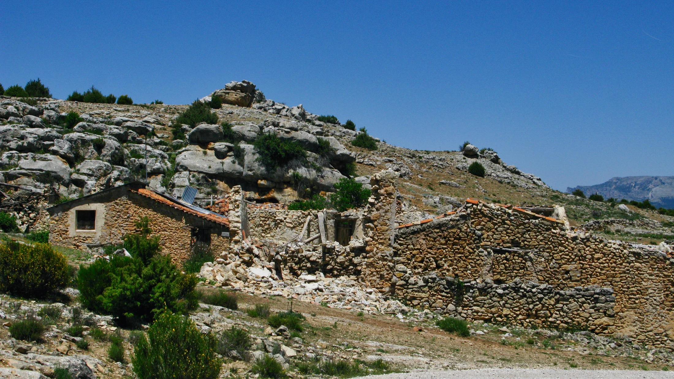
6.Granadilla (cáceres): Walled town by the reservoir
Granadilla was expropriated in the 1950s during the Gabriel y Galán reservoir project; water never reached its streets, but families were displaced and the town fell quiet. Since 1984, Spain’s educational recovery program has slowly rebuilt parts of this walled medieval town. Swallows stitch loops over the crenellated walls. It stands today as both a lesson and a living workshop.
You can walk intact streets, circle the walls, and climb the restored castle tower for sweeping views across the reservoir and dehesa. Citron lichen freckles the masonry like gold dust. Entry is usually free with posted hours; some buildings house small exhibits and restoration areas. Respect fenced work zones and student projects—this is a classroom as much as a site.
Reach Granadilla from Plasencia or Hervás via regional roads towards the reservoir; signage is clear in the final kilometres. Pair the visit with kayaking or birdwatching on the Gabriel y Galán shores, or with the chestnut forests near Hervás. “Granadilla turismo” information published by Extremadura’s heritage bodies is regularly updated; check hours in advance, particularly outside spring–autumn.
7.Jánovas (huesca): River village returning
Jánovas, on the wild Ara River, was forcibly emptied for a dam project decades ago; after prolonged legal battles, the project was shelved, and families began returning. Stacked stone walls rise where weeds once ruled. The iron bridge hums softly in the wind. Reconstruction is ongoing, and some houses are now private homes again.
Visitors can walk the main street, see the church shell, and admire the stitched repairs where new meets old. River light flickers on the undersides of leaves like fish scales. Trails along the Ara offer superb scenery—this is one of Spain’s last free-flowing Pyrenean rivers. Stay off scaffolding and respect signed private property: this is a living village in transition, not a static ruin.
Access from Aínsa or Boltaña along N-260 towards Fiscal, then local turn-offs signposted to Jánovas. Park only in designated spaces; the road is narrow and sees service vehicles. Late spring to early autumn gives warm days and safe river levels for walking; winter can be icy in the mornings. Local councils and Aragón’s environmental agency publish notices when works or river conditions restrict access.
8.Umbralejo (guadalajara): Slate architecture and quiet learning
Umbralejo forms part of Spain’s black slate villages—stone-dark houses built from schist and slate in the Sierra Norte de Guadalajara. Evacuated in the 1960s, it is now used by the national educational program PRUEPA, which runs residential workshops on rural heritage. A woodsmoke memory clings to cool, shaded alleys. Because of its role, general visits are limited to specific open days.
When open, you’ll find restored roofs, the church, and traditional urban layout with narrow lanes and low doorways. Slate flakes glitter like fish skin under angled sun. Interpretive panels sometimes explain carpentry, dry-stone, or traditional tools; do not move objects or enter closed buildings. If the site is closed, explore nearby villages like Majaelrayo, Campillo de Ranas, or Valverde de los Arroyos as part of the Black Architecture Route.
Reach the area via CM-1006 and local roads; the last approach includes a maintained track. Weather turns quickly on these ridges, and winter often brings snow; boots and layers are smart even in shoulder seasons. Check opening days with the regional park or educational program offices, and remember that the landscape thrives thanks to local councils and craftspeople keeping traditions alive.
9.Caudilla (toledo): Ruins on the La Mancha plain
Caudilla’s crumbling castle-palace stands isolated amid cereal fields near the A-5, a classic roadside silhouette known to photographers driving between Madrid and Extremadura. Wheat whispers against a dry-stone fence in the breeze. Its 15th-century origins and later alterations left a geometry of windows and buttresses that still holds an arresting profile.
There’s not much to “do” beyond appreciating the form, the sky, and the exposed brick and ashlar. Thunderheads pile behind the open arch like a theatre set. The building is fragile, and access inside is unsafe and typically prohibited; fences or warning signs are sometimes in place. Keep distance, avoid crop damage, and yield to farm machinery—this is an active agricultural landscape.
From Toledo, take the A-42 and connect to the A-5 west, exiting near Maqueda and following local signs to Caudilla. Best light sits at sunrise or sunset, with late-summer fields painting ochre bands under the castle. Wind can be fierce; bring a weight for tripods, and use vehicle doors as windbreaks when swapping lenses.
10.Convento de Nuestra Señora de los Ángeles (segovia): A monastery in silence
Set within the Hoces del Río Duratón Natural Park, the remains of the Convento de Nuestra Señora de los Ángeles cling to a rocky spur above the river. Griffon vultures circle on thermal columns like slow clocks. The monastery, abandoned long ago, survives as cliff-perched walls visible from surrounding viewpoints; interior access is unsafe and prohibited.
What you can expect: soaring views, the hush of the canyon, and the thrill of spotting raptors, orchids, and river life from legal lookouts and trails. Honeyed light spills along travertine ledges at dusk. Pair the outing with the well-known San Frutos hermitage viewpoint for classic canyon panoramas; park rules protect nesting seasons and often regulate boating and trail access.
Reach the park from Sepúlveda or Sebúlcor and follow marked roads to official car parks; posted panels explain seasonal limitations and fragile habitats. Bring binoculars and a telephoto lens; the best images are from distance, and stepping off-trail erodes the very ledges that hold the monastery together. For deeper history, consult Segovia’s provincial heritage resources and the park’s own interpretation materials, which compile archival research and conservation notes.
Activities and Highlights Around the Ruins
Exploring ruins is richer when you weave in the landscapes and stories around them. Each site sits in a living mosaic of farms, forests, rivers, and communities, and your day can stretch beyond collapsed walls. Dried fennel rattles softly as you shoulder a daypack. Think in themes—photography, walking and cycling, memory routes, waterways, and simple picnics that put you in the landscape without leaving a trace.
Photography is the most obvious draw. Aim for low-angle light, bracket exposures in high-contrast scenes, and use a polariser for stone textures. A fingertip brushes gritty mortar like sandpaper. Tripods help at dawn and dusk; check if they are allowed and avoid blocking narrow alleys in places like Corbera or Belchite during guided tours. On windy plains like Caudilla, hang a small weight from your tripod to reduce shake.
Walking and cycling expand your field of view. In the Prades Mountains, string La Mussara into a loop with nearby lookouts on signed PR trails. In the Ara valley, a partial ride along N-260 with side roads brings you to Jánovas vistas—ask about traffic and shoulders at the tourism office in Aínsa before pedalling. Pebbles ping the downtube on quiet descents. In the Alpujarra, short off-road strolls from safe pull-outs around Tablate give elevated angles without risking crumbling edges.
Memory and interpretation routes anchor the Civil War sites. At Corbera d’Ebre, combine the Poble Vell with the 115 Days interpretation centre and other Ebro front positions mapped by the Memòria Democràtica initiative. At Belchite, a guided visit layers names, dates, and urban context onto what otherwise reads as pure texture; trained guides draw on municipal records and regional archives to keep narratives rigorous. The cool interior of a centre smells faintly of paper and dust.
Wildlife and river outings pair beautifully with Granadilla and the Duratón. Rent kayaks on the Gabriel y Galán reservoir for calm paddling among dehesa reflections—operators usually run 45–90 minute sessions in season; confirm prices and safety gear included. Water slips along the hull with a hush like silk. In the Duratón, stay on designated trails and official water routes; raptor nesting windows limit launches and landing points, and viewing from established miradores is both legal and spectacular.
Simple picnics—done right—turn a quick stop into a lingering memory. Sit in shade well away from structures, pack reusable containers, and use a small sit pad to avoid damaging plants. The snap of a crisp apple echoes slightly against a stone wall. Choose local products where possible: Alpujarra cheeses, Extremaduran ibérico, or Aragonese olive oils support the people who still work these lands. In all cases, pack out everything, including citrus peels and nut shells, which take time to break down and attract wildlife.
Finally, check the local calendar. Some towns host remembrance walks, talks, or open-house days aligning with restoration projects (Granadilla, Umbralejo) or memorial anniversaries (Belchite, Corbera). Bells toll from a modern church in the new town while the old one stands as silhouette. These events add depth—voices, context, and community presence—turning a ruin into a place of connection rather than just a backdrop.
Practical Tips and Safety
Respect and preparation transform evocative ruins into safe experiences. Many structures are fragile, ownership is complex, and rural services spread thin. The smell of warm thyme mixes with old stone as you shoulder your pack. Use the checklist below to plan a responsible day and reduce risks for you and for the sites.
-
Gear to carry:
- Sturdy footwear with grippy soles; rubble rolls underfoot like marbles.
- 2 litres of water per person in summer; electrolytes help in dry, windy sites.
- Headlamp for dawn/dusk; keep hands free on uneven ground.
- Sun kit: hat, sunglasses, SPF 50+, light long sleeves.
- First-aid basics: blister care, bandage, antiseptic, pain relief, space blanket.
- Offline maps (IGN or equivalent) and a power bank; valleys and steppe often lack coverage.
- Light gloves for scrambling-free photography on rough stone; never use hands to pull on walls.
-
Legal and ethical basics:
- Assume private property unless clearly public or signed; ask locally if in doubt.
- Do not enter fenced or posted areas; interior access is the highest-risk behaviour.
- Take nothing, move nothing; even a loose brick belongs to the site’s integrity.
- Keep noise low in memorial towns; these are outdoor museums and places of grief.
- Drones: many sites sit within natural parks or near towns; follow AESA rules and local bans, especially around wildlife colonies (Duratón vultures).
- Photography for commercial use may require permits from councils or heritage bodies.
-
Fieldcraft for fragile ruins:
- Walk on durable surfaces: existing paths, rock, or compacted ground.
- Step one at a time on rubble; test edges with a trekking pole.
- After rain, skip overhangs and banks; saturated soils crumble without warning.
- Never lean tripods on historic walls; rubber feet only and keep a margin.
-
Moving around and communicating:
- Share your plan and ETA with someone, especially when coverage is patchy.
- Travel in pairs or groups; one person can fetch help if needed.
- In emergencies, dial 112; describe nearest road numbers (
A-222,C-43, etc.) and use GPS coordinates indd.ddd°if possible. - Weather checks: AEMET forecasts are reliable for local wind and heat advisories in plains and canyons.
-
Social sensitivity and community:
- Buy lunch or supplies in nearby towns; your euros help maintain services that keep rural Spain alive.
- Listen to locals about access and safety; farmers and rangers know recent changes.
- On remembrance sites (Belchite, Corbera), avoid costumes, props, or “ruin porn” staging; dignity first.
Important
Unstable structures can collapse without sound or warning. If in doubt, keep your distance and choose the safer photo from farther back.
A final word on kids and pets: choose sturdier sites like Granadilla for family visits with clear paths and walls, and keep toddlers in hand. Dog paws slide easily on loose gravel; leashes protect wildlife and livestock and prevent falls near edges.
Frequently Asked Questions
Is it legal to visit these abandoned places?
Generally yes if you stay on public roads, marked paths, and areas explicitly open to visitors. Fences, gates, “no entry” signs, or active restoration zones indicate private or restricted property. When in doubt, ask at the nearest tourism office or town hall and never force access.
Which places are best for families with children?
Granadilla is excellent thanks to restored streets and walls, and Duratón viewpoints offer safe, well-signed trails. Belchite and Corbera can work with older kids on guided tours. Avoid unstable hamlets like Tablate’s edges or interior climbs in any ruin; carry snacks, water, and set clear boundaries.
When is the best time to avoid crowds and heat?
Late autumn, winter weekdays, and early spring bring thinner crowds and softer light. Summer heat is intense in Andalusia and La Mancha, so aim for sunrise or sunset. In mountains like La Mussara, fog and quick weather shifts mean flexible plans and layers are essential year-round.
Can I fly a drone over these sites?
Often no. Many lie within or near protected areas or towns where drone use is restricted. AESA regulations apply nationally, and parks like Hoces del Duratón have specific wildlife protections. Always check local rules and respect no-fly zones; manned guided tours may also prohibit drones for safety.
How can I be respectful on Civil War memorial sites?
Treat them like open-air museums: quiet voices, no staging, no moving debris, and follow marked routes. Guided visits at Belchite and interpretation centres around Corbera provide context from documented sources and ensure your visit contributes to preservation rather than damage.
Where can I find updated hours and access information?
Local town halls, provincial tourism offices, natural park visitor centres, and site-specific memorial centres publish the latest schedules. IGN and AEMET help with maps and weather. For Umbralejo and Granadilla, check education and restoration program notices tied to opening days.
Book your experience — discover outdoor and cultural activities across Spain with providers verified by Picuco.
Conclusion
These places are quiet, but they’re not empty. Each ruin holds craft, conflict, and community memory, from the stitched streets of Granadilla to the scorched façades of Belchite and Corbera. A cool gust runs through a window arch like a whispered name. Visiting them responsibly—by staying on paths, respecting hours, and supporting nearby towns—keeps their stories available to future travelers and to those who still call these landscapes home.
Plan by clusters, travel with respect, and carry what you need to be self-sufficient. Early or late light repays patience with colour and texture, and local voices add nuance you can’t get from stone alone. Dust your boots at the car door, pack out every crumb, and take only photographs and understanding. When you’re ready to turn inspiration into action, explore curated activities that connect you with local guides, parks, and heritage centres, and make your next escape a conversation with the land rather than a conquest.