The essentials of Parque Natural de Llevant

  • • Talaia Freda (564 m): 360-degree views over the Bay of Alcúdia and the Capdepera coast
  • • 14 waymarked hiking routes through holm-oak woodland and coastal cliffs
  • • Mediterranean tortoise (Testudo hermanni) with an active breeding and reintroduction programme
  • • Arenalet d'Albarca and es Matzoc coves, foot-access only with Posidonia seagrass beds
  • • Public estates with traditional Mallorcan rural architecture: possessions, dry-stone walls and lime kilns

Description

The Parc Natural de la Península de Llevant covers 1,671 hectares on Mallorca's north-eastern tip, spanning the municipalities of Artà and Capdepera. Declared a natural park in 2001 and incorporated into the Natura 2000 network, it protects a stretch of coast and low mountains where Mediterranean woodland, sea cliffs and hard-to-reach coves have kept tourist pressure unusually low. The public estates of Albarca, es Verger and s'Alqueria Vella, former livestock latifundia, form the park's core and preserve rural infrastructure — possessió farmhouses, dry-stone walls, lime kilns — that document centuries of agricultural use.

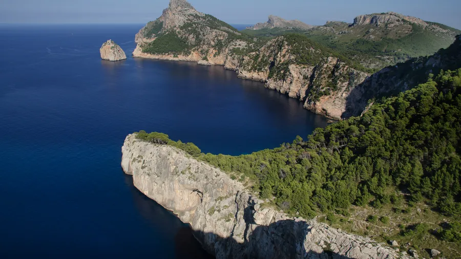
The park's terrain is shaped by the Llevant ranges, the eastern extension of the Serra de Tramuntana with lower altitude but the same limestone character. Talaia Freda (564 m), the highest point, provides a 360-degree panorama taking in the Bay of Alcúdia to the north, the Capdepera coastline to the east and Mallorca's central plain to the south-west. Other notable peaks include Bec de Ferrutx (519 m), Puig des Porrassar (491 m) and Puig de sa Tudossa (441 m). Ravines running from the ranges to the sea form intermittent streams that feed small coastal wetlands.

The park offers 14 waymarked hiking routes across distinct ecosystems. The s'Alqueria Vella to es Verger trail (7 km one way) passes through mature Mediterranean holm-oak woodland with Quercus ilex specimens over 300 years old, interspersed with wild olives (Olea europaea var. sylvestris) and Aleppo pines (Pinus halepensis). The s'Esquena Llarga route descends to the northern coves, where limestone rock drops straight into the turquoise Mediterranean — the contrast between dry garriga scrub and blue sea is best appreciated at dawn, when low-angle light picks out the stone textures.

The Mediterranean tortoise (Testudo hermanni), a species declining across its European range, maintains one of its most stable Balearic populations in Llevant. The park participates in a breeding and reintroduction programme coordinated with the Govern de les Illes Balears. Beyond the tortoise, the park hosts raptors such as Bonelli's eagle and the peregrine falcon, plus a significant seabird community on the coastal cliffs. In spring, the garriga fills with bloom: cistus, rosemary, heather and over 40 documented wild orchid species in the damp meadows at the valley floor.

The northern coves — Arenalet d'Albarca, es Matzoc, Cala Estreta — are accessible only on foot after walks of 45 minutes to 2 hours from trail starting points. This absence of motorised access preserves Posidonia oceanica seagrass beds in good condition and water of remarkable clarity. The s'Alqueria Vella refuge, managed by Ibanat (Institut Balear de la Natura), offers basic accommodation with advance booking for hikers, allowing overnight stays in the heart of the park and early morning starts when wildlife activity peaks.

Practical information

Everything you need to know for your visit to Parque Natural de Llevant

How to get there
From Palma de Mallorca, take the Ma-15 to Artà (65 km, about 55 min). From Artà, follow local road signs to the park (10 min). There is no direct public transport into the park; a private vehicle is recommended. Parking available at s'Alqueria Vella and the Artà access point.
Area Information
The park lies in north-east Mallorca between Artà and Capdepera. Artà (about 7,800 pop.) is the nearest service centre with accommodation and restaurants. Cala Rajada, 12 km away, has a wider tourist offering. S'Alqueria Vella refuge for overnights.
Geography
Limestone ranges extending the eastern Tramuntana. Highest point: Talaia Freda (564 m). Ravines with intermittent streams reach cliff-flanked coves. Garriga, holm-oak and Mediterranean pine. Rocky coast with Posidonia beds.
Flora & Fauna
Holm-oak woodland with Quercus ilex specimens over 300 years old, wild olive, Aleppo pine and garriga of cistus and rosemary. Over 40 wild orchid species. Mediterranean tortoise (Testudo hermanni), Bonelli's eagle, peregrine falcon and seabird communities on coastal cliffs.

Things to do

Find the best plans and things to do in Parque Natural de Llevant

20

Accommodations

Best accommodation options in Parque Natural de Llevant

Loading accommodation options...

Frequently Asked Questions

Get answers about Parque Natural de Llevant

Yes, the s'Alqueria Vella refuge, managed by Ibanat (Institut Balear de la Natura), provides basic accommodation for hikers with bunk beds and a shared kitchen. Advance booking through the Ibanat website is required. Wild camping is not permitted anywhere within the park boundaries.
The coves of Arenalet d'Albarca, es Matzoc and Cala Estreta are accessible only on foot from the park's trailheads. The shortest walk takes about 45 minutes; the longest exceeds 2 hours. There is no motorised or commercial maritime access, which keeps the coves in a high state of conservation with Posidonia beds and very clear water.
Yes, the Mediterranean tortoise (Testudo hermanni) lives in the park and is especially active between March and June during the early morning hours. Sightings are not guaranteed but are frequent in garriga and low-altitude meadow areas. The park asks visitors not to touch or disturb the animals.
Yes. Between June and September, depending on the forest fire alert level declared by the Conselleria de Medi Ambient, some trails may close temporarily. It is advisable to check access status on the Ibanat website or at the park office in Artà before setting out on a hike.
Park trails range from easy to moderate difficulty. The main challenge is summer heat: carry at least 2 litres of water per person, sun protection and a hat. Hiking footwear is essential, as parts of the trails cross rocky limestone terrain. There are no drinking water points along the routes.