The essentials of Parque Natural de las Hoces del Cabriel

  • • The Cabriel is Valencia's cleanest river by physicochemical water quality data
  • • Canyon over 300 m cut through Mesozoic limestone and dolomite over millions of years
  • • Kayaking for all levels: grade II-III rapids and calm pools, water 18-20 °C in summer
  • • Otters, European pond turtles and Júcar basin endemic fish species in the river
  • • Low tourist pressure: quiet secondary road access and deliberately simple infrastructure

Description

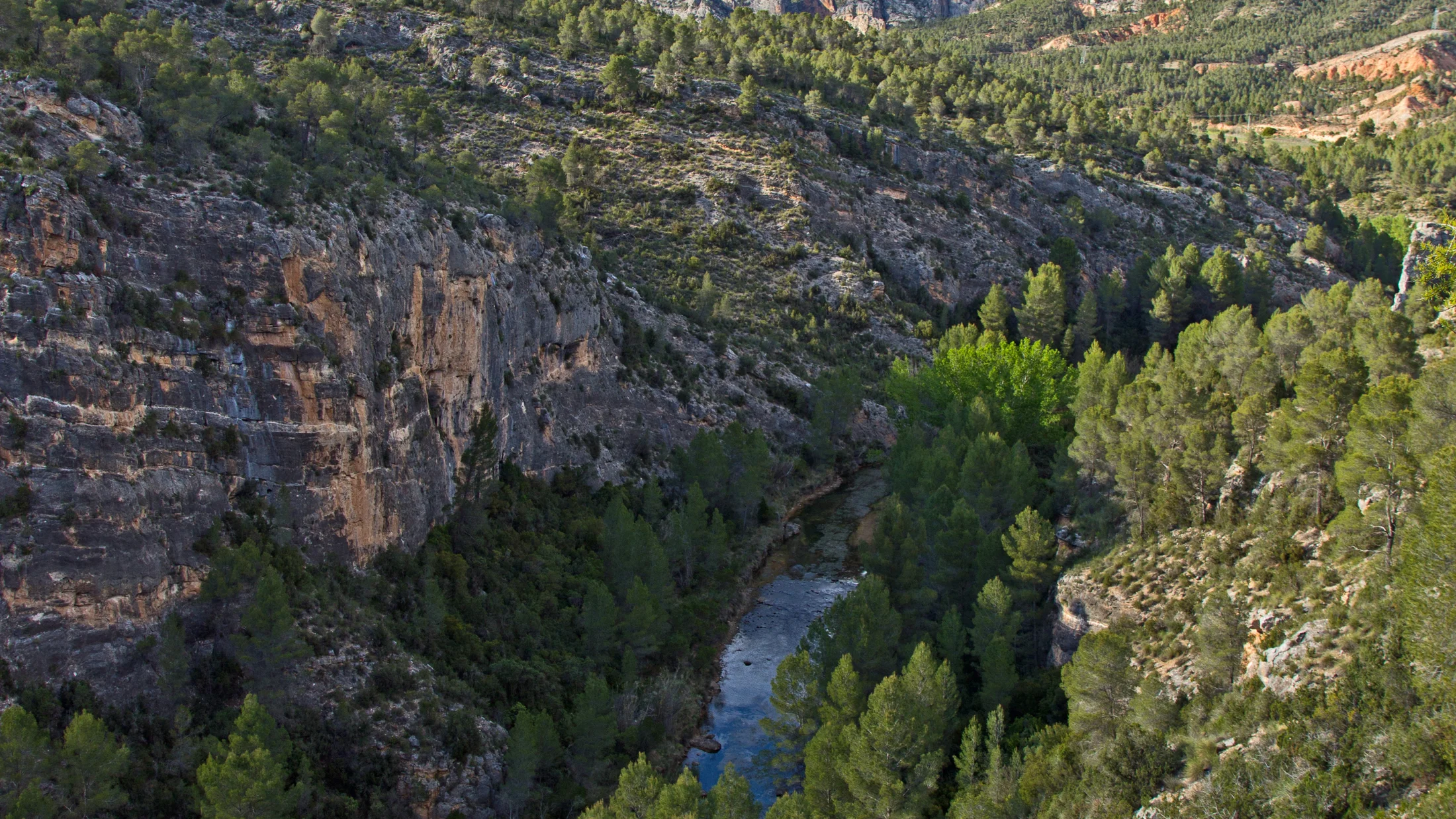
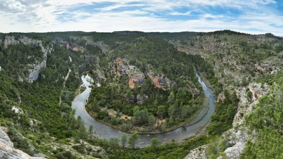
The Hoces del Cabriel Natural Park protects the most dramatic stretch of the Cabriel river as it crosses the provinces of Cuenca and Valencia, where the river has carved a canyon over 300 metres deep through Mesozoic limestone and dolomite. The park, declared in 2007, covers around 31,000 hectares across several municipalities and takes its name from the vertical cliffs — hoces — that the river has sculpted over millions of years. Spanning more than 80 kilometres of protected river course, the Cabriel is the cleanest river in the Valencia region by physicochemical water quality, according to national water data.

Kayaking or canoeing the Cabriel is the activity that draws most visitors to the park. Local companies offer routes of 8 to 18 kilometres at varying difficulty levels: the lower sections are suitable for families with no experience, while the upper stretches include grade II-III rapids for more advanced paddlers. The river alternates between deep, quiet pools — the water a deep green from the riverside vegetation — and short rapids. In summer, water temperatures around 18-20 °C make swimming a natural part of the day.

The park ecosystem reflects a confluence of Mediterranean, continental and minor Atlantic climate influences. The riverine forest of the canyon floor — alder, ash, willow and poplar — contrasts with the holm oak scrub and Pyrenean oak pine forest covering the slopes and upper plateau. Griffon vultures, red-billed choughs and peregrine falcons nest in the cliff faces. The Cabriel also provides habitat for otters, European pond turtles — a vulnerable species — and several endemic fish of the Júcar river basin.

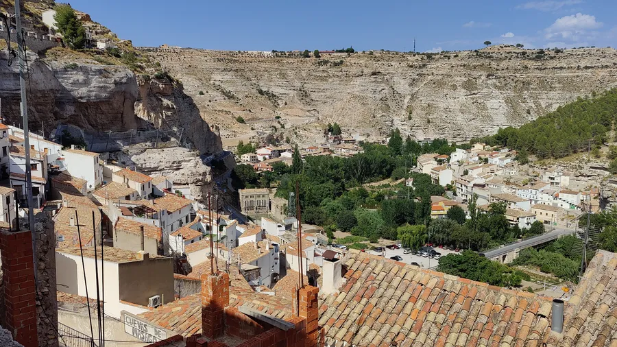
The park has no single visitor hub. Reference towns are Enguidanos on the Cuenca side and Villargordo del Cabriel on the Valencia side. Access is via quiet secondary roads, which adds to the sense of isolation that characterises the experience. Tourism infrastructure is deliberately low-key: campsites, rural houses and activity companies managing boat hire and transport between launch and take-out points. This absence of large-scale services is part of the appeal for visitors seeking a natural environment with low tourist pressure.

In the surrounding area, the comarca of La Manchuela (Cuenca) and the Canal de Navarrés (Valencia) offer cultural and heritage interest. Las Majadas, a small village on the Cuenca bank, gives direct access to one of the most photographed canyon sections. The source of the Cuervo river, about 50 km north along mountain roads, is another common day trip for those spending several days in the area.

Practical information

Everything you need to know for your visit to Parque Natural de las Hoces del Cabriel

How to get there
From Madrid, take the A-3 towards Valencia to Motilla del Palancar, then the CUV-8031 to Enguidanos (approx. 220 km). From Valencia, the A-3 to Requena then local roads to Villargordo del Cabriel (approx. 90 km). No public transport to launch points.
Area Information
Natural park declared in 2007, jointly managed by Castilla-La Mancha and Valencia regions. Main municipalities: Enguidanos (Cuenca) and Villargordo del Cabriel (Valencia). The park is among the least crowded on the Peninsula due to its restricted access.
Geography
The Cabriel carves over 80 km of protected canyon through Mesozoic limestone and dolomite reaching over 300 m in depth. The 31,000-hectare park spans Cuenca and Valencia provinces at altitudes between 600 and 1,200 m.
Flora & Fauna
Riverine forest with alder, ash and poplar on the canyon floor. Holm oak and Pyrenean pine on the slopes. Wildlife: otter, European pond turtle (vulnerable), bermejuela and calandino endemic fish, griffon vulture, peregrine falcon and red-billed chough.

Things to do

Find the best plans and things to do in Parque Natural de las Hoces del Cabriel

20

Accommodations

Best accommodation options in Parque Natural de las Hoces del Cabriel

Loading accommodation options...

Frequently Asked Questions

Get answers about Parque Natural de las Hoces del Cabriel

Not for the basic sections. Local companies offer easy-level routes with gentle rapids suitable for families with children from around 4-5 years old. For sections with grade II-III rapids, some experience or physical fitness is recommended. All companies provide life jackets, helmets and paddles, plus a brief technique briefing before launch.
The most common routes are 8 to 12 km and take 2 to 4 hours on the water, not counting transport. Companies move participants' vehicles to the take-out point to simplify logistics. Some operators also offer full-day routes of up to 18 km.
Yes. Designated swimming areas are available at several points along the river. The water is clean and temperatures in summer range from 18 to 20 °C. Swimming in the calm pools is one of the highlights of a kayak trip on the Cabriel. Outside marked zones, caution is advised due to current and rapids.
The villages of Enguidanos and Casas de Garcimolina on the Cuenca side, and Villargordo del Cabriel on the Valencia side, have campsites and rural houses. Capacity is limited and advance booking in July-August is advisable. The park is a long drive from the nearest cities, so staying at least one night is the most common approach.
The source of the Cuervo river, about 50 km north along mountain roads, is a popular day trip: the river emerges from limestone rock forming a waterfall and a tufa system walkable in under two hours. In Cuenca city (70 km), the hanging houses and UNESCO World Heritage historic centre round out a longer visit to the region.