The essentials of Somiedo Natural Park

  • • Lagos de Saliencia: five glacial lakes between 1,500 and 1,700 metres altitude
  • • Cantabrian brown bear: one of the densest populations in the mountain range
  • • Teitos: thatched traditional huts, a vernacular architecture unique in Europe
  • • Puerto de Somiedo (1,486 m): historic livestock pass between Asturias and León
  • • Brañas and vaqueiros de alzada: living transhumance tradition in the high mountains

Description

Somiedo Natural Park occupies the south-central area of Asturias, spanning the headwaters of the Sil and Pigüeña rivers in Cantabrian high mountain terrain that rarely exceeds 2,000 metres but concentrates an unusual density of natural and cultural values for northern Spain. The watershed with Castilla y León runs along the southern edge of the park, and the mountain passes crossing it — Puerto de Somiedo (1,486 m), Puerto de la Ventana (1,587 m) — served for centuries as livestock routes connecting Asturian summer pastures with Castilian winter pastures. This transhumant function left behind a landscape of teitos — traditional thatched huts with wooden frames and broom-grass roofs — that are the most recognisable element of local vernacular architecture.

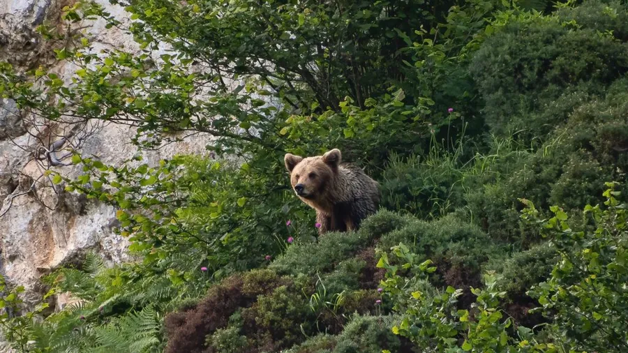
The Cantabrian brown bear has one of its most secure strongholds in Somiedo. The western bear population, shared between Asturias, León and Galicia, recovered from its historical low in the 1980s thanks to protection measures and a reduction in hunting pressure. Sightings are possible but uncommon for casual visitors: bears prefer oak and beech woodland at mid-to-high altitudes and areas of blueberry and bramble scrub, and avoid zones of high human activity. The best months for observation are May and June, when animals descend to lower meadows in search of food after winter.

The Lagos de Saliencia are the most visited lake group in the park: five glacial lakes sitting between 1,500 and 1,700 metres in a steep-walled cirque. La Cueva, the largest, is roughly 400 metres long and over 20 metres deep. The trail connecting all five lakes from the Saliencia car park covers about 9 km round trip with roughly 400 metres of accumulated elevation gain, crossing alpine grasslands and wet heathlands where mosses and lichens carpet the limestone rock. The view from the col above the lakes looking north, with the Asturian valleys in the background, is one of the park's defining images.

The vaqueiro de alzada culture — transhumant livestock communities that move between high-altitude summer pastures (brañas) and coastal winter villages — is directly tied to this landscape. Although active transhumance has declined sharply in recent decades, some families maintain the practice, and the park preserves the natural context in which this way of life developed over centuries. The brañas have individual names in each valley and concentrate the teito architecture that ethnographers consider unique in a European context. The park's forests range from Atlantic heathland at the summits to mixed oak and beech woodland lower down.

Practical information

Everything you need to know for your visit to Somiedo Natural Park

How to get there
From Oviedo, the AS-15 reaches Pola de Somiedo in about 80 km (approx. 1h 30min). For the Lagos de Saliencia, continue through the Valle del Lago to the Saliencia car park (paved track, about 10 km more). There is no regular public transport into the park interior.
Area Information
The natural park (29,121 ha) covers the municipalities of Somiedo, Belmonte de Miranda and part of Tineo. The service hub is Pola de Somiedo. The Somiedo Nature Interpretation Centre in the village is open year-round.
Geography
Cantabrian high mountain terrain between the Sil and Pigüeña basins. Highest point: Cornón (2,194 m). Glacial cirques at the valley heads, with the Lagos de Saliencia as the main lake group. Alternating limestone and slate bedrock.
Flora & Fauna
Mixed oak and beech forest at mid-elevation; Atlantic heathland and alpine grassland at high altitude. Cantabrian brown bear, Iberian wolf, roe deer, Cantabrian capercaillie (critically endangered) and otter in the rivers. Wild orchids in damp meadows.

Things to do

Find the best plans and things to do in Somiedo Natural Park

20

Accommodations

Best accommodation options in Somiedo Natural Park

Loading accommodation options...

Frequently Asked Questions

Get answers about Somiedo Natural Park

The probability of a spontaneous bear sighting is low for the unspecialised visitor. Bears are discreet animals that avoid human contact. The best chances are at dawn and dusk in May and June, watching low-altitude meadows from elevated viewpoints with binoculars. Several local specialist companies organise guided wildlife watching excursions with precise knowledge of recent activity zones.
Yes. The circular route linking all five lakes from the Saliencia car park covers about 9 km with around 400 metres of accumulated elevation gain. A person in good physical condition can complete it in three to four hours. The access track to the car park from the Valle del Lago is 10 km of paved road. In high season, private vehicle access may be restricted, with a shuttle bus from Pola de Somiedo.
Teitos are traditional pastoral huts whose roofs are made of native broom or rye straw, held up by a wooden frame built without metal nails. The best-preserved examples are in the brañas of Mumián, La Pornacal, El Caleyón and La Peral. Some are still in active use as shepherd shelters; others have been restored with regional government support. Most can be visited from outside without restriction.
Yes. Pola de Somiedo and the valley villages have rural guesthouses, pensions and a couple of small hotels. In the La Pornacal braña there is a mountain refuge with limited capacity that requires advance booking. Staying at least one night in the area is strongly recommended: most of what makes Somiedo interesting requires early starts or access from points far from the main car parks.
Partly. The track to the Saliencia car park is paved and accessible by vehicle. The first section of the lakes trail up to the viewpoint over La Cueva lake is relatively level though unpaved. The rest of the route through the glacial cirque involves uneven, rocky terrain and steep sections that make it inaccessible for wheelchairs or very limited mobility.