Why Zumaia’s Flysch Belongs on Your Coastal Itinerary
The Zumaia flysch compresses 50 million years of Earth history into cliffs you can touch. You’ll find this rare rock library on the Basque Coast between Zumaia, Deba, and Mutriku, where layered strata fold like pages of an atlas and Atlantic waves carve them clean. For hikers, families, and anyone who loves big seascapes, it’s an unforgettable day out with science you can actually see. As the breeze lifts salt off the breakers, the cliffs glow slate-gray and honey in shifting light.
This guide shows you how to visit safely and well: what the flysch is, why it matters scientifically, when to go (tides are everything), and how to reach Itzurun Beach in Zumaia by train, bus, or car. You’ll get practical hiking routes—from an easy Itzurun loop to the classic Zumaia–Deba traverse—and alternatives for stronger walkers to Mutriku, plus a low-tide itinerary for geology lovers. We also cover flysch boat tours, the Basque Coast Geopark’s main viewpoints, and where to stay and eat.
If you’re traveling with children, you’ll appreciate short seaside paths, clear vantage points, and simple tips that make the most of the tides. If you’re a photographer, expect to work the hour around low tide for mirror pools and leading lines; if you’re a geology fan, the famed K–Pg boundary at Zumaia is a pilgrimage. Lace up, plan with the tide tables, and give yourself time to slow down. Rock, ocean, and weather set the rhythm here.
Picuco te puede ayudar
Does something here catch your eye?
Tell us.
Write to us on WhatsApp or email: we answer questions, find the best options and help you sort out the booking.
Escríbenos
What “flysch” Means and Why Zumaia’s Cliffs Matter
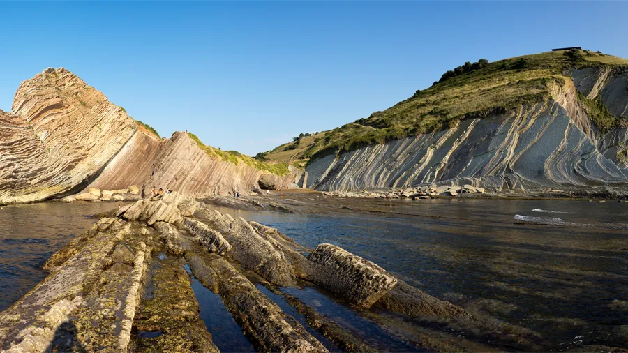
“Flysch” is a geological word for rhythmically alternating layers—typically hard sandstone or limestone and softer marl or shale—deposited in deep marine basins by submarine avalanches called turbidites. In plain terms: the cliffs you see are a rock layer cake, each sheet a pulse of ancient sediment that slid down underwater slopes, then hardened over millions of years. At Zumaia, these layers tilt steeply and crop out along the coast, so you see a cross‑section as if a giant sliced through a colossal roll of pages. When a swell sighs across the platform, the stripes shine as though polished.
Zumaia’s outcrops are exceptional because they preserve a continuous record from the Late Cretaceous into the Paleogene, with annual to millennial detail you can count in places like tree rings. The Basque Coast Geopark (Geoparque de la Costa Vasca) highlights several globally significant horizons here, including the K–Pg boundary—short for Cretaceous–Paleogene—the time (~66 million years ago) when a mass extinction wiped out non‑avian dinosaurs. At Zumaia’s Itzurun cliffs, researchers have measured iridium anomalies, microfossil turnovers, and a dark clay interval linked to the impact event, making it one of Europe’s classic K–Pg references (see International Commission on Stratigraphy notes; key papers in Geology and Earth and Planetary Science Letters report on Zumaia sections).
Beyond that single boundary, Zumaia also hosts internationally ratified “golden spikes” (GSSPs) for the Selandian (2008) and Thanetian (2011) stages of the Paleocene, chosen by the International Commission on Stratigraphy because the sequence is continuous, fossil‑rich, and well dated. If “GSSP” sounds cryptic, think of it as the official bookmark where a slice of geological time starts, tied to a physical layer you can visit. In educational terms, this coastline functions like an outdoor lab: students read foraminifera (microscopic shells), count turbidite stacks, and compare limestone–marl rhythms to ancient climate cycles paced by Earth’s orbital variations.
The Basque Coast Geopark joined the European Geoparks Network in 2010 and became a UNESCO Global Geopark in 2015, a recognition of both scientific value and community stewardship. Local guides, town councils, and landowners cooperate to keep paths signed, manage access, and interpret the geology for visitors. You’ll notice bilingual signage (Basque/Spanish) around Zumaia explaining both rocks and cultural history; take a minute to read them before you step out. With each wave slapping the platform, you feel how ocean, stone, and people share one working coast.
Plan Before You Go: Location, Seasons, Tides, and Transport
Visiting the Zumaia flysch is simple if you anchor your plan to two variables: location and tide. Zumaia sits an easy hop from Donostia–San Sebastián by train or car, and Itzurun Beach is a short stroll from the old town. But your window onto the rock platform expands or shrinks with the tide, and Atlantic swell can change everything. As gulls wheel above San Telmo’s white chapel, the sea breathes in and out along the striped pavement below.
Where you are: Zumaia, Itzurun, and the Basque Coast Geopark
Zumaia is a small coastal town in Gipuzkoa province, about 35 km west of Donostia–San Sebastián and 70 km east of Bilbao. The heart of the flysch sector lies between Zumaia and Deba within the Basque Coast Geopark, continuing to Mutriku. Itzurun Beach (Playa de Itzurun) sits just north of Zumaia’s old town below the Ermita de San Telmo on a high promontory. For orientation, the beach is roughly at 43.296°N, 2.258°W (approximate), with the town’s Euskotren station about 10–12 minutes’ walk inland. In late afternoon, the cliffs redden as if they stored the day’s warmth.
Key reference points:
- Itzurun Beach access: west end of the seafront, signed stair/ramp down.
- San Telmo Hermitage: above the western end of the beach; top-of-cliff lookout.
- Geopark Visitor Info: interpretive panels near Itzurun and along coastal paths.
- Wider sector: Sakoneta cove and Elorriaga viewpoints halfway toward Deba.
The Geopark covers 13 municipalities along 90 km of coast and inland valleys, but the iconic striped flysch is concentrated on the Zumaia–Deba stretch. Keep that focus for your first visit.
Best time to go, tide windows, and the safest hours
You can visit year‑round, but spring and autumn offer mild temperatures (15–22°C), clearer air for photography, and manageable crowds. Summer brings warmer water and more services, but mid‑day heat on cliff paths can feel exposed. In winter, Atlantic storms sharpen the light and the wave energy; it’s dramatic and risky. When the wind smells of iodine and wet limestone, you know the swell is up.
Low tide is crucial if you want to walk the wave‑cut platform or study the layers at eye level. Use tide tables for nearby ports (Mutriku, Getaria, or Pasaia) via Puertos del Estado or Euskalmet. As a rule of thumb:
- Best exploration window: from 90 minutes before to 60 minutes after low tide, if swell is low.
- Avoid: rising tide with significant swell; narrow coves like Sakoneta can trap you.
- Golden light: the hour after sunrise and the hour before sunset, especially around low tide.
Always prioritize safety over access. If waves overtop the platform or a set crashes across your planned line, retreat to the upper beach or cliff path.
Getting there: train, bus, car, and routes from San Sebastián
Zumaia is well connected along the N‑634 corridor with frequent Euskotren services and regional buses. From Donostia–San Sebastián, walking time from station to Itzurun is under 15 minutes. On summer mornings, the platform crowds thicken like a small pilgrimage to the sea.
Transport snapshot:
- Euskotren: Bilbao–Donostia line stops at Zumaia. Expect 45–55 minutes from Donostia–Amara to Zumaia; 1 h 50–2 h 10 from central Bilbao. Trains run at least hourly, more often at peaks. Check “Euskotren E1” timetables and plan buffer time.
- Lurraldebus/regional buses: services link Donostia, Zarautz, Getaria, and Zumaia in 40–60 minutes depending on route and traffic. Use official Lurraldebus timetables and allow for summer crowding.
- Car: from Donostia, take the AP‑8/A‑8 west, exit toward Zumaia on the GI‑631/N‑634; 35–40 minutes in normal traffic. From Bilbao, 60–80 minutes via the A‑8 east. Parking near Itzurun is limited, a mix of street and pay zones; town lots fill on weekends.
- Rideshare/taxi: practical for one‑way hikes (e.g., Deba back to Zumaia) if schedules don’t align.
For Zumaia hiking along the ruta del flysch, consider a one‑way traverse with public transport return. If starting early from San Sebastián without a car, take an Euskotren to Zumaia for the Zumaia–Deba line hike, then return from Deba by train.
Staying and eating: simple, local, and well located
Zumaia and neighboring coastal towns offer everything from family‑run hotels to agroturismo farm stays within a short drive of the trails. In high season (late June to early September), book at least 2–4 weeks ahead; shoulder seasons are gentler, but weekends still fill. When the evening cool carries woodsmoke from inland baserri farmhouses, a hot plate of hake or grilled squid tastes like the coast itself.
Practical pointers:
- Where to stay:
- In Zumaia old town for easy access to Itzurun and the station.
- Rural agroturismos in the hills between Zumaia and Deba for quieter nights and quick drives to viewpoints like Elorriaga.
- Nearby Zarautz or Getaria if you want broader dining scenes and consistent buses/trains.
- Where to eat:
- Pintxos in the old town bars for a quick post‑walk bite.
- Local seafood (hake, anchovies, squid) and simple cider‑house menus in season.
- Picnic on the cliff paths only where allowed; carry out all waste.
If you plan a dawn or low‑tide session, ask your host about early breakfasts or pack food the day before.
Walking the Flysch: From Easy Loops to Classic Traverses
You don’t need to be an expert to enjoy the Zumaia flysch, but you do need a plan that matches the tide and your fitness. The routes below run on good coastal tracks with occasional steep ups and downs, plus optional rock‑platform exploration at low tide. As your boots thud on firm trail, the rumble of distant surf follows like a constant drum.
1.Itzurun short loop (circular): best for families and photography
- Distance/time: 2–3 km loop, 60–90 minutes with stops.
- Start/finish: Itzurun Beach access in Zumaia.
- Difficulty: easy; some stairs; keep children close near cliff edges.
- Highlights: San Telmo Hermitage, cliff‑top views, easy access to the beach at low tide.
Route notes:
- From the beach access, climb to the Ermita de San Telmo for your first overview of the Flysch de Zumaia and the sweep of Itzurun. Continue along the signed cliff path west for balcony views, then loop back through town lanes.
- For photographers, the hour around low tide reveals mirrored pools and sharp leading lines on the platform; shoot with a wide lens and stable footing. When a thin film of water ripples across the rock, the sky reflects as a shifting sheet of glass.
- Safety: do not go under unstable overhangs; watch for falling rocks after rain or swell.
- Gear: sturdy shoes with grip, light wind layer, and a small pack; trekking poles optional.
This is the simplest way to understand “Itzurun Zumaia” as both a beach and a vantage point over the larger coastal story—perfect if you have little time or are visiting with kids.
2.Zumaia–deba (linear): the classic line and how to return
- Distance/time: 14–16 km one way, 4–5.5 hours depending on pace.
- Elevation gain: around 500–700 m total ascent in rolling ups and downs.
- Waymarking: largely follows the
GR-121(red‑white blazes) and local coastal signs.
Route notes:
- Start at Itzurun and take the cliff‑top path west. The trail undulates across pasture margins, wood edges, and open headlands. You’ll pass views to coves and the striped platform, with options to detour down where signed and safe at low tide. On blustery days, the grass whips like waves under the wind.
- Tricky bits: short steep descents can be slick in rain; mud lingers under forest shade. Keep well back from unfenced edges.
- Deba arrival: the path descends to Deba town and beach; cafes and the train station are close.
- Return logistics: take Euskotren back to Zumaia (20–25 minutes, hourly or better), or a regional bus if it suits your schedule. In high season, consider booking dinner in Deba and a later train home.
Pack 1.5–2 liters of water per person, snacks, and a light shell even on bright days. Trail runners or hiking shoes with good grip are ideal.
3.Zumaia–mutriku (coastal): a long day with cutoffs for strong hikers
- Distance/time: 22–25 km, 7–9 hours including breaks.
- Elevation gain: 900–1,100 m total; repeated climbs sap energy—pace accordingly.
- Waymarking:
GR-121segments and local coastal signage; occasional country lanes.
Route notes:
- The first half mirrors the Zumaia–Deba track. Beyond Deba, the path stays scenic and quieter, with big views across the Bay of Biscay and tighter, steeper valleys. Old farm paths thread hedgerows and small hamlets, showing how people have worked these slopes for centuries. In late day, cowbells carry like soft metronomes between folds of land.
- Variants to shorten:
- Zumaia–Deba only (stop in Deba).
- Deba–Mutriku segment if you position transport at each end.
- Bailout to Deba from mid‑route signed junctions.
- Finish: Mutriku is a handsome fishing town with sheltered harbor; buses back toward Deba/Zumaia are less frequent than trains—check schedules before you commit.
This is a big coastal walk: start early, bring a headlamp in winter, and expect weather to shift. Strong winds magnify exposure on open ridges.
4.Low-tide geology route: strata and fossils without harm
- Focus: explore the rock platform safely around low tide for close looks at layers.
- Start/finish: Itzurun Beach, optional ventures toward Algorri/Sakoneta depending on conditions.
- Timing: plan to be on the platform 60 minutes before low tide; add a 30‑minute exit buffer.
How to do it:
- Check “mareas Zumaia” via Puertos del Estado or Euskalmet for Getaria/Mutriku.
- Match low tide to daylight hours and small swell; avoid any day with strong onshore winds.
- Descend to Itzurun and identify alternating hard/soft bands; use a hand lens if you have one. When you touch the limestone, it feels cool and smooth; the marl crumbles softer to the nail.
- Look, don’t collect: photographing fossils, trace structures, and the K–Pg interval is encouraged; removing samples is not.
- Exit the platform at least 30 minutes before the tide turns if swell is rising; waves can close your route faster than you’d think.
Recommended kit: grippy shoes you don’t mind wet, small first‑aid kit, and a drybag for electronics. This is a superb “ruta del Flysch” option if you want hands‑on geology without a long hike.
Boat Trips, Key Viewpoints, and Things to Do
Seeing the flysch from sea level is revelatory, but so is the high angle from cliff balconies. Mix perspectives if you can: a short boat ride and a few hours on foot create a full picture. When a boat’s wake fans across the platform, the cliff bands look like organ pipes set into the coast.
1.Boat visits and guided excursions: why and how to book
Flysch boat tours depart from Zumaia’s small harbor and trace the coast beneath Itzurun toward Deba and back. The main advantage is perspective: you see the entire cliff face at once, with guides pointing out key layers, faults, and the flow of the coastline. On a glassy morning, the cliffs ripple in the water like a barcode.
Practical notes:
- Duration and frequency: common formats run 60–90 minutes; daily in summer, weekends in spring/autumn, occasional in winter when seas allow.
- Pricing: expect roughly 12–25 € per adult, family packages and student rates available; confirm current prices with the operator.
- Conditions: departures depend on weather and swell; cancellations are common after storms.
- Booking: reserve a day or two ahead in peak season, and choose earlier/later slots for calmer seas and softer light.
- Accessibility: some boats accommodate limited mobility; ask about ramps and seating.
For context and safety, guided outings organized through the Basque Coast Geopark network highlight geology and coastal culture, and many operators offer English‑language commentary on the Flysch de Zumaia within the Geoparque Costa Vasca.
2.Itzurun: the beach, cliffs, and unmissable lookouts
Itzurun is the iconic starting point—a sandy cove framed by towering, tilted strata and the white Ermita de San Telmo above. Access is straightforward from the town side via stairs and a ramp; lifeguards work in high season, and services open along the waterfront. At low tide, the beach extends onto the rock platform like a stone terrace laid by giants.
What to see and photograph:
- Cliff‑top from San Telmo: classic overview of the beach and bands; sunrise/sunset both work.
- Low‑tide platform: leading lines and tidal pools; always watch incoming sets.
- Eastward glimpses toward Getaria’s mouse‑back hill, and west to Sakoneta’s raw coves.
Tips:
- Avoid standing under unstable overhangs and wet cliff faces.
- In summer, go early or late to skip crowds and get better light.
- Respect signage and seasonal nesting zones.
3.Ermita de San Telmo: history, access, and the views
The small San Telmo Hermitage sits on the cliff above Itzurun, dedicated to the patron of sailors and darling of local weddings and festivals. A short, signed path climbs from beach level in 5–10 minutes, and the effort opens one of the finest balconies on the Basque coast. When bells ring in the quiet, the sea’s hush answers from below.
Why stop here:
- Cultural layer: chapels to San Telmo dot Atlantic coasts where fishing shaped life.
- Orientation: clear sightlines east and west help you plan which way to hike next.
- Pairings: combine with the Itzurun loop, or use it as your first check on swell and tide before a longer route.
Please keep voices low during services, stick to the path edges near the cliff, and tuck in poles to avoid brushing the small hedge and railings.
4.Elorriaga and other coastal view points: quieter tracks
West of Zumaia and approaching Deba, the Elorriaga area offers headland views without the bustle of Itzurun, accessed by rural lanes and short paths. Here, rolling pastures lean to the cliff lip, and waves trace chalky lines across the rock platform below. A light onshore wind smells of cut grass and seaweed.
How to visit:
- Access: reach Elorriaga by car from Deba/Zumaia on signed country roads, then walk 10–20 minutes on easy track to the cliff edge.
- Advantages: fewer people, broad views of the striped platform, good picnic spots (pack out all waste).
- Photographers: long lenses pick out fault offsets and curvature in the bedding; mid‑tide can highlight the contact between wave foam and rock shelves.
Other balconies include signed lookouts along the GR-121 and country lanes that crest ridges before dipping into small valleys. Always park off the road, leave gates as you found them, and greet farm residents—you’re walking where people work.
5.Sakoneta: wild coves and rock textures
Sakoneta, between Zumaia and Deba, is a sequence of small coves and a broad wave‑cut platform famous for tight banding, slump folds, and tide‑shaped pools. Access involves country lanes and paths that drop to the shore; signage varies, and the last section can be rough. When the tide draws back, the platform reveals tiles and ribs like a petrified dragon’s back.
Plan it right:
- Timing: only at or near low tide; swell must be small.
- Hazards: slippery algae, surge channels, and loose rock under eroding slopes.
- Payoff: close‑range views of rhythmic layers, small fossils in situ (do not remove), and sea‑polished forms.
If in doubt, keep to the cliff path above and look down. On storm days, watching the sea explode across the platform from a safe height is spectacle enough.
6.Top activities: coastal hiking, photography, tide watching, and geo‑tourism
This coast rewards simple plans done well. Choose a primary activity and let the others fall into place around it. As a low swell combs the shore, each band of rock catches a different shine.
- Coastal hiking:
- Best first day: Zumaia–Deba on the
GR-121, with a coffee at either end. - Family option: Itzurun loop plus a short out‑and‑back on the cliff path.
- Strong walkers: extend to Mutriku with early start and bailout options.
- Best first day: Zumaia–Deba on the
- Photography:
- Low tide for leading lines; bring a microfiber cloth and rubber soles.
- Blue hour from San Telmo; polarizer helps manage glare on wet rock.
- Tide and wave observation:
- Arrive 60–90 minutes pre‑low; watch for sets before stepping out.
- Note how hard and soft bands erode differently—an easy science lesson for kids.
- Geo‑tourism and learning:
- Read on‑site panels about the K–Pg layer Zumaia is known for and look for color changes across the boundary.
- Join a guided walk or flysch boat tour for context; English tours are often available in summer.
For a full 1–2 day visit, pair one boat tour with one hike, then keep a flexible slot for a low‑tide platform session if conditions allow.
Practical Advice, Safety, and Frequently Asked Questions
A safe, rewarding visit to the Zumaia flysch requires basic gear, tide awareness, and courtesy for the land and those who live by it. As clouds move like sails over San Telmo, the coast shows both its welcome and its edges.
Safety and recommended gear
Stay comfortable and reduce risk with a short checklist. Cold wind, wet rock, and fast‑rising tides catch unprepared visitors.
- Footwear: grippy hiking shoes or trail runners; avoid smooth soles on the platform.
- Clothing: layers for wind and spray; a light waterproof even on clear days.
- Essentials:
- 1.5–2 liters of water per person on longer routes.
- Snacks and a basic first‑aid kit.
- Sun protection: hat, sunglasses, high‑SPF sunscreen.
- Weather: check Euskalmet forecasts; wind and swell change access quickly.
- Cliffs and platform:
- Keep back from unfenced edges; rock edges can undercut.
- Never stand under fresh rockfall zones or wet overhangs.
- On the platform, watch for algae‑slick surfaces and surge in channels.
If seas boom louder and spray advances across the platform, treat it as a warning to step back to the beach or climb to the path.
Tides, permits, and responsible access
The Zumaia–Deba–Mutriku coast includes protected zones within the Basque Coast Geopark where conservation comes first. A little knowledge goes a long way.
- Tides: consult Puertos del Estado or Euskalmet for daily tide times; match your plan to the low‑tide window and build in exit buffers.
- Collecting: do not remove fossils, rocks, or plants; photographing and sketching are welcome alternatives.
- Path etiquette: stay on signed trails; close gates; yield to farm vehicles and respect livestock.
- Drones: Basque coastal cliffs are sensitive areas; you must comply with Spanish AESA regulations and any local restrictions—assume a permit is required and that launches are prohibited near people.
- Group visits: for school or large groups, book guided activities through recognized operators; they coordinate access and safety.
Think of the flysch as an open‑air museum: touch gently, leave what you find, and help keep it whole.
Accessibility and options for reduced mobility
Zumaia offers meaningful views even if steep steps and uneven rock are not for you. With planning, visitors with reduced mobility can enjoy key vantage points.
- Itzurun Beach: ramp access from the seafront promenade (gradient varies); sand and rock platforms are not wheelchair‑friendly.
- San Telmo: the chapel sits atop stairs and sloping paths; not fully accessible.
- Harbor and promenade: smooth surfaces near the marina afford sea views and easy seating.
- Boat tours: some operators can accommodate reduced mobility; inquire about ramp boarding, seat stability, and restroom access.
- Town services: accessible parking bays and adapted restrooms are available in central Zumaia; confirm locations with the tourist office.
For an inclusive visit, aim for:
- A harbor promenade circuit for sea air and views.
- A vehicle‑accessed headland like Elorriaga for clifftop vistas near the car.
- A short, flat segment of coastal lane where gradients are minimal.
Plan transfers and rest breaks into your day, and avoid low‑tide platforms and cliff stairs.
What is the best time to visit Zumaia’s flysch?
The best hour blends low tide, soft light, and fewer people. Match your visit to a low‑tide window that lands in early morning or late afternoon, and you’ll see more and photograph better.
- Tides first: aim to arrive 60–90 minutes before low tide to step onto the platform as it opens, with a 30‑minute exit buffer after low.
- Light: sunrise gives clean color on east‑facing bands; sunset warms the west. Overcast days cut glare on wet rock.
- Crowds: weekdays outside school holidays are quiet; in summer, go early or late.
Use Puertos del Estado or Euskalmet tide tables for Getaria/Mutriku ports and check swell forecasts; if the sea roars and sprays the platform, save the close‑up for another day. When a calm morning lays the sea flat, the platform reflects the sky like brushed steel.
Can you see the flysch by boat and on foot?
Yes, and each option shows a different truth. Boats reveal the entire cliff face and the sweep of the platform from a safe distance; walking puts your hands and eyes on textures and fossils.
- Boat advantages:
- Panoramic view of layers, faults, and headlands.
- Guided interpretation and safe access regardless of tide (subject to swell).
- Good for families and reduced mobility (ask about access).
- On‑foot advantages:
- Close study of strata on the platform at low tide.
- Flexible pacing and photography angles from clifftop to rock level.
- Immersion in the landscape’s sounds and smells.
If you have one day, do a morning boat ride and an afternoon Itzurun loop, or the classic Zumaia–Deba hike if you prefer land. When you step off a moving boat into town, the cliffs feel like a living wall breathing with the sea.
Are there guided routes or educational activities?
Yes. The Basque Coast Geopark framework supports guided coastal walks, geology‑focused outings, and flysch boat tours, with options for schools and families.
Options include:
- Geology walks: short, themed routes that explain the K–Pg boundary, turbidites, and local fossils in clear language.
- Coastal hikes: guided versions of Zumaia–Deba or segments thereof, timed to tide and weather.
- Boat tours: commentary in multiple languages in peak season; shorter duration for mixed‑age groups.
- School programs: curriculum‑linked visits with age‑appropriate fieldwork.
Why choose a guide?
- Safety: tide timing, swell assessment, and hazard avoidance.
- Learning: see more with trained eyes; understand what you’re seeing.
- Logistics: transport, pacing, and rest stops handled for you.
Book in advance for weekends and holidays. On breezy days, a guide’s call to turn back can make the difference between a great memory and a close call.
Can I search for fossils and take samples home?
Look, identify, and photograph—but do not take. This coastline is a protected scientific resource, and removing fossils or rock samples is prohibited.
- What’s allowed:
- Observing and photographing fossils, sedimentary structures, and layers.
- Sketching, note‑taking, and using a hand lens in place.
- What’s not allowed:
- Chiseling, prying, or pocketing any fossil or rock.
- Disturbing cliff bases, overhangs, or protected zones.
Alternatives:
- Visit local museums or information centers for curated specimens and explanations.
- Join guided walks that show classic fossils in situ without damage.
- Use field guides or apps to ID what you see and leave every piece in place.
Each small fossil left where it lies keeps the record intact for the next visitor and for future research. The faint imprint of a shell on sun‑warmed stone is richer when it stays in the world.
Book your experience — explore verified outdoor activities in Spain with trusted providers on Picuco.
Conclusion
Zumaia’s flysch is where Earth’s deep time stands in open air, and where your choices—tide window, walking route, or boat tour—turn that time into an experience. A day here can be as simple as a family loop over Itzurun and a picnic in the wind, or as focused as a geology walk to the K–Pg layer with a lined notebook and a hand lens. As evening drops, cliffs fade from silver to charcoal and a last gull rides the thermal up San Telmo’s wall.
Plan with tides, pick one strong activity, and treat rock and community with care. If this coast leaves you wanting more, extend your trip to nearby Getaria and Zarautz for additional seaside walking, or push west toward the Urdaibai estuary for different geology and birdlife. Share what you learn, and come back in another season; the ocean writes a new margin on this stone page every day.