Why This Route Belongs on Your Asturias Shortlist
Why choose the Alba Route?
If you are chasing a simple plan with big rewards, the Alba Route Asturias delivers. You follow a crystal river into a narrowing gorge, with a finale at a graceful waterfall and emerald pools. Set inside Redes Natural Park (a UNESCO Biosphere Reserve since 2001), it blends scenery, water, and village warmth in one day out.
Starting in Soto de Agües, you walk a historic path shaped by herders and miners that now feels made for families and slow hikers. You move from open valley to canyon, passing stone bridges, old water channels, and shady beech and chestnut. One sensory moment stands out: the cool drift of spray on your face as the ravine tightens.
Expect a well-marked track for much of the way, then a narrower footpath that adds a hint of adventure without turning technical. The Parque Natural de Redes protects both wildlife and local livelihoods, so you share the trail with neighbors who still cut hay and keep cattle. Carry that respect with you, and you will find an easy, memorable day where the sound of the Alba River sets your pace.
Key facts: location, best time and duration
- Location: Soto de Agües (municipality of Sobrescobio), Nalón valley, Asturias, within Redes Natural Park.
- Official trail code:
PR-AS 62(also called Senda del Alba), as signposted on site and in regional hiking refs by the Principality of Asturias. - Distance: 13–15 km out-and-back to the end of the gorge (Cruz de los Ríos area), depending on exact turnaround point.
- Elevation gain: roughly 250–350 m total, spread gently across the route.
- Typical time: 4–5 hours return at a relaxed pace, plus stops for photos, picnic, or a careful dip.
- Season: Year-round, but spring and early summer bring the most water; autumn offers color; winter can bring ice and snow on shaded sections.
- Water conditions: After heavy rain, the river runs high and fast; pools may be unsafe for bathing, and rocks become slick.
Choose late spring for flow and flowers or September–October for calmer weather and golden beech leaves. In midwinter, start late morning for sun on the valley; in summer, early starts beat the heat and crowds. One quick image to hold: sunlight flickers like coins on the Alba’s riffles where the path hugs the bank.
Data above draws on on-site panels in Sobrescobio, regional hiking materials from the Principality of Asturias, and IGN 1:25,000 topographic coverage for Redes Natural Park.
Picuco te puede ayudar
Does something here catch your eye?
Tell us.
Write to us on WhatsApp or email: we answer questions, find the best options and help you sort out the booking.
Getting to the Trail from Soto De Agües
Road access from Soto de Agües
Cómo llegar Ruta del Alba is easy once you reach the Nalón valley. From Oviedo, follow the AS-17 towards Rioseco (Sobrescobio capital), then the local road signed to Soto de Agües; allow 60–70 minutes for the 50–55 km drive. From Pola de Laviana, it is about 25–30 minutes via the AS-17; from Mieres, plan roughly 1 hour using AS-242/AS-17 via Sama or a similar connection.
The final kilometers are on a narrow, paved local road with passing places; you will see brown tourist signs to Senda del Alba/PR-AS 62. Surfaces are generally good year-round, but in autumn leaf-fall and winter frost can make bends slippery. A brief sensory cue: as you roll down the last bend into Soto, the river’s hush swallows engine noise.
If you use a sat-nav, set destination to “Soto de Agües, Sobrescobio.” Avoid routing through rough forest tracks; the official access is the paved village road from Rioseco. Road and sign information aligns with DGT and local council signage as of recent seasons—always check for temporary works after storms.
Public transport and alternatives
Public transport reaches the valley, then you finish by short transfer. Buses operated under the Consorcio de Transportes de Asturias (CTA/CTPA) run Oviedo–Rioseco services several times daily on weekdays, with reduced weekend frequency. From Rioseco to Soto de Agües is a short local hop by taxi (around 3–5 km) or a 40–60 minute walk on the local road.
Check current timetables on the CTPA official channels before travel; seasonal adjustments are common. If you base in Laviana or Langreo, regional buses connect to Rioseco as well. For lower-impact travel, consider:
- Car sharing among your group to minimize vehicles in village streets.
- Cycling from Rioseco to Soto on the local road if you are comfortable with light traffic and short climbs.
One sensory note: stepping off the bus at Rioseco, the scent of damp stone and alder rises from the river.
Parking and trailheads in Soto de Agües
Soto de Agües is small, so park with care. There is informal, free parking at the village entrance and signed areas on the outskirts; on peak weekends, spaces fill by mid-morning. Do not block farm gates or narrow lanes—agricultural traffic is active every day.
From parking, walk into the village following brown signs to Senda del Alba/PR-AS 62; the trail begins at the end of the main lane by the river. Early birds find the calmest start, while late arrivals may need to park further out and stroll in. The simple sensory scene here: boots crunch on cobbles as the first sound of the river threads through chatter from the bar terrace.
Local guidance on parking and access comes from Sobrescobio council notices and on-site panels; any new restrictions after storms or high-risk periods will be posted at the entrance.
Trail Description and Difficulty
Step-by-step itinerary
- Start: Main lane of Soto de Agües, follow
PR-AS 62waymarks upstream along the Alba River. - 0–2 km (30–40 min): Wide, gently rising track between pastures and alder. Pass early stone features and reach La Pontona bridge, a stout, photogenic span with mossed parapets.
- 2–4.5 km (45–60 min): The valley narrows; the track edges closer to the river with short, protected drops. Small waterfalls appear, and the path alternates between old path and improved sections.
- 4.5–6.5 km (50–70 min): Enter the gorge. The track becomes a footpath clinging to the slope with occasional rails and channels from historic waterworks. Cross several bridges that frame churning chutes.
- 6.5–7.5 km (20–30 min): Final approach to the waterfall zone (Cruz de los Ríos area). Here you find the Alba waterfall viewpoint and nearby pools; turn around at signed end or where conditions allow a safe view.
- Return: Retrace the same way to Soto de Agües, allowing a similar time with fewer photo stops.
Segment times above are for a steady pace with brief pauses; families may add 30–60 minutes. After rain or in winter, add caution time for slick rock. Hold one image: foam ribbons twirl below a timber handrail as the path threads the narrows.
Waymarking follows yellow-white PR stripes and local wooden posts; junctions are few, and the canyon confines make navigation intuitive. IGN topographic base shows the track closely paralleling the river, with the turnaround near the confluence known locally as Cruz de los Ríos.
Elevation, distance and who it suits
- Total distance: 13–15 km out-and-back (variable by turnaround point).
- Elevation gain: roughly 250–350 m total; gradients are mostly gentle.
- Highest exposure: Short sections above the river with railings; no technical scrambling required.
- Surface: Compacted track, packed soil, occasional rock steps; slippery when wet.
We rate difficulty as Easy–Moderate: easy for experienced hikers, moderate for families due to length. It is excellent for active kids used to 10–12 km walks; less experienced families can shorten the outing by turning around at La Pontona bridge or before the tightest gorge sections. Consider poles for balance on wet days.
Two cautions shape your day: river spray makes shaded rock slick, and water levels rise quickly after storms—both argue for steady footing and conservative decisions. A single sensory beat: your palm brushes cool lichen on a parapet while you steady for a photo.
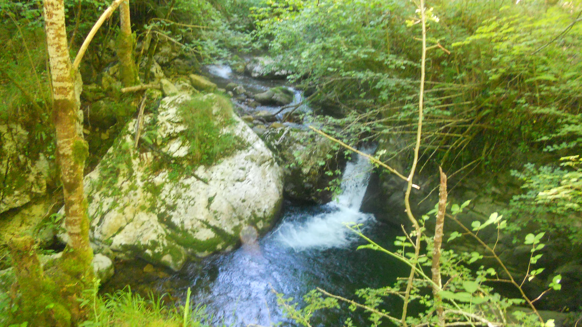
What to See: Waterfall, Pools, Bridges and Mining Heritage
Cascada del Alba: what it looks like and where to view it
The cascada del Alba drops in a clean white veil into a rocky bowl framed by beech and fern. In average conditions, its visible fall is in the order of 8–12 m, fed by the river’s narrowed chute as it tumbles from the head of the gorge. Spring snowmelt and sustained rain produce the most dramatic flow, while late summer softens it to a graceful ribbon.
Viewpoints are signed near the end of the route; respect barriers and do not step onto wet boulders for a closer shot. Best light arrives mid-morning when the ravine eases its shade; after heavy rain, mist hangs and lenses fog. Picture the air here: a fine spray beads on your forearms, and the roar fills the small amphitheater.
These tips match guidance from on-site signage and common-sense canyon safety used across Asturias’ PR network.
Natural pools on the Alba Route: where to dip and what to watch for
The pozas Ruta del Alba gather in calm pockets where bedrock forms round basins below short drops. You will see several clear pools in the mid to upper sections before the final gorge constriction. Depth varies by season; in summer, mid-calf to chest-deep bowls appear, while spring floods scour and reshape them.
Water temperature stays cold year-round—often 8–14°C—so limit immersion to brief dips and avoid sudden plunges if you feel chilled. Enter slowly, check footing for slick algae, and never swim near fast water or just above a cascade. Local norms in Redes emphasize conservation: keep soaps and sunscreens out of the water, avoid trampling banks, and leave no litter.
Early afternoon offers warmer rock for drying, but mornings provide solitude. A single image to guide you: sunlight patches waver over granite pebbles, then vanish as a cloud slides across the gorge.
Bridges and crossings: photo spots and rural architecture
La Pontona bridge and smaller stone crossings anchor the route’s human touch. Built in local ashlar with simple arches and thick parapets, they speak of centuries of foot traffic and mule trains tied to herding and mining. Later timber walkways and rails add discreet safety where the slope pinches.
For photos, frame bridges from slightly downstream to catch both arch and river curve; step back to include mossy walls and overhanging hazel. Keep tripods clear of the walkway and yield to others—space narrows in the gorge. Think of this short image: a damp, moss-green sheen halos the stones as the river slides below.
Mining remains: history at your feet
Redes carried a modest but real mining past; along this path you may notice cut stone alignments, old water channels, and remnants tied to small hydro and local extraction. Information panels in Sobrescobio outline how pack routes connected valley hamlets to larger transport down the Nalón.
Do not climb on structures or enter any fenced area; treat them as open-air archives. Parents can spark curiosity by spotting drill marks in stone or old iron fixings and asking kids how people moved ore without trucks. Fix in mind a single scene: rust-brown flecks on an old bolt glow against grey rock, a quiet footnote to the roar of water.
Recommended Activities Along the Route
Come for the walk, but give yourself time to play it wide. In warm months, bring a towel and plan short, careful dips in knee- to waist-deep pools well away from fast current. Practice “toe test” entries: slide one foot, check grip, then commit, keeping shoulders above water if you are sensitive to cold. A short sensory line anchors it: river-cool skin prickles, then a breeze wraps you warm as you step back onto sunlit stone.
Photography pairs well with the Alba’s contrasts—white water, dark rock, bright leaves. Pack a cloth for spray, and favor mid-morning or late afternoon to dodge harsh midday glare in the canyon. Try:
- Wide angles at La Pontona to lean into the curve of the parapet.
- A short telephoto in the gorge to compress cascades and handrails into layered lines.
- Smartphone long-exposure modes on a mini bean bag instead of a tripod when space is tight.
Picnicking is easy if you keep it simple. Choose existing clearings and rock benches; avoid fragile banks and do not feed wildlife. Pack out all waste, including citrus peels and nutshells that linger in wet, cool environments. Families can set “lunch rules” with kids: 20 minutes, one viewpoint, then another 20 minutes to keep the return before mid-afternoon.
Nature-watching rewards patience. Redstarts and dippers flit low over riffles; salamanders hide below stones; beech and birch trade leaf tones through the year. Bring compact binoculars and a small field guide or app, and keep voices soft—quiet opens windows wildlife will not. One image to hold: a flash of white from a dipper’s breast blinks on and off like a tiny beacon in the spray.
Trail running fits the first half’s wide track, but slow down in the gorge. If you run, go at off-peak times, yield early, and communicate clearly; bells or loud music clash with the place and with other visitors. Cyclists will enjoy access roads around Rioseco and Laviana, but the narrow upper footpath of PR-AS 62 is for feet only; respect signs to keep everyone safe.
Finally, stitch your day with local stops. A coffee in Soto de Agües before you start, or a sidra and a simple meal after, completes the rhythm of this valley. Those moments are how tourism folds back into community, one coin in the till and one hello at the bar.
Practical Tips and Safety
Gear and clothing for this Redes Natural Park hike
The terrain is friendly but wet: pack for grip and spray. Wear grippy hiking shoes or boots with a defined tread; trail runners with sticky soles work in summer. Dress in layers: breathable base, light fleece, and a waterproof shell—the gorge funnels showers even on “dry” days.
Add:
- 1–1.5 liters of water per person; refill at village, not the river.
- Snacks with salt and crunch; wet air can dull appetite.
- Small first-aid kit and blister care.
- Fully charged phone in a zip bag; offline map of
PR-AS 62helps in case signs are down. - Light gloves in shoulder seasons; a hat for drizzle or sun.
In winter, microspikes can help on icy mornings; in summer, pack a small towel for quick dips and a thin warm layer for post-swim chill. One sensory note: the tap-tap of your poles on stone blends with the river and steadies each step.
Timing and planning to dodge crowds
Start early. On weekends and holidays, aim to leave Soto de Agües by 8:30–9:00 a.m. to enjoy a quiet gorge and easy parking. In shoulder seasons, late afternoons can be magical, with slanting light and fewer feet on the track.
Time plan for a full route with pauses:
- Outbound to waterfall area: 2–2.5 hours.
- Lunch/photos/swim stops: 45–90 minutes total broken into short rests.
- Return: 1.75–2.25 hours.
This keeps you back in the village mid- to late afternoon without rushing. Always leave a margin: shaded upper sections darken early in autumn and winter. Fix one soft image: the gorge exhales cool air as the day tilts, reminding you to turn for home.
Environmental rules and responsible behavior
Redes Natural Park rules ask you to be a good guest. This means:
- Stay on the marked
PR-AS 62path; cutting banks damages roots and invites erosion. - Pack out all waste; organic peels and nut shells do not vanish fast in cool, wet climates.
- Do not pick flowers or branches; many species support specialist insects and birds.
- Keep dogs leashed near livestock and in the gorge; control prevents conflict and protects wildlife.
- No fires or barbecues—period.
- Keep noise low; let the river be the soundtrack.
Municipal bylaws can carry fines for littering or fire risk; the Park may restrict access during emergencies. Current rules are posted on official Principality of Asturias and Park channels and on signs at the trailhead. Hold one simple image: a clean bank where leaves and stones read as they are, unmarked by us.
Faqs and Nearby Essentials
Is the Alba Route suitable for children and dogs?
Yes, for most active families and well-managed dogs. The full out-and-back from Soto de Agües can reach 13–15 km, which is long for small kids; shorten by turning back at a midway landmark like La Pontona bridge. The path is mostly easy, but expect narrow, sometimes slick sections in the gorge.
Keep dogs leashed near livestock and whenever the path runs above the river. Carry water for pets and watch for paw slips on wet stone. For younger kids, plan frequent micro-breaks and a turnaround time rather than a fixed destination—Soto de Agües is a welcoming base no matter how far you go.
Can you swim at the waterfall and in the pools?Is it safe?
You can take careful dips in calm pools well away from cascades and fast flows, but you should never swim at or just above the waterfall. The main risks are cold shock (water often 8–14°C), slick algae on rock, and sudden push from current even in seemingly quiet spots. Enter slowly, keep within your depth, and get warm quickly after.
After rain or during spring melt, skip bathing entirely—currents surge and visibility drops. Obey any temporary restrictions posted by the Park or council; conservation takes priority. A common-sense test rules here: if you hesitate, do not enter.
Do I need a permit or to pay to access the route?
Access to the Alba Route is currently free, with no permit required for day hiking from Soto de Agües. Parking is generally free in designated village areas. Special activities (organized events, filming, large groups) may need authorization from the Park or municipality.
For updates, consult official channels of the Principality of Asturias and Redes Natural Park, or the Sobrescobio town hall noticeboard. If conditions change after storms or for conservation, you will see temporary notices at the trailhead.
How is the signposting—do I need Gps or a map?
Signposting on PR-AS 62 is generally clear with yellow-white PR marks and wooden posts at key points. The route follows the river and has few junctions, which helps. Still, a basic offline map or a GPX track on your phone is wise insurance if a post is down or fog settles.
Recommended approach:
- Download an offline map covering Sobrescobio/Redes before arrival.
- Save a GPX of the
PR-AS 62line from a trusted source. - Carry a paper overview map if you prefer analog backups.
In the gorge, GPS can drift under steep walls; visual checks with waymarks remain primary. As a mental image: a small painted stripe on a rock edge pops bright against damp grey.
What lodging and services are near Soto de Agües?
Soto de Agües and nearby Rioseco offer small rural guesthouses, apartments, and family-run inns; the wider Nalón valley (Pola de Laviana, Langreo) adds more options. You will also find cafés and traditional eateries in the village and along the valley roads. Weekends and holidays in spring–autumn book quickly—reserve in advance.
Shops are limited in Soto, so bring snacks and picnic supplies or plan to dine after your hike. Many places keep traditional hours; an early start pairs well with a late lunch. Local stays help sustain the valley’s year-round life—you see that support in trimmed meadows and maintained paths.
Book your experience — discover outdoor activities across Spain with providers verified by Picuco.
Conclusion
The Alba Route Asturias is the kind of day that stays with you: a gentle valley walk into a narrowing gorge, the hush and brightness of water, and a warm return to Soto de Agües. Its mix of cascada del Alba, calm pools, old bridges, and traces of work along the river tells a full story in a few unhurried hours. Plan your timing, tread lightly, and let the river set your cadence.
If you are staying in the Nalón valley, combine this outing with other Redes Natural Park hikes—like beechwood rambles near Caso or short balcony walks above reservoirs—to round out a long weekend. Book lodging ahead in high season, then fill the gaps with simple valley meals and conversations on village steps. When you are ready to explore more across Spain, browse activities on Picuco and keep building days like this—local, nature-first, and at your own pace.