Introduction
Why look for hikes so close to Madrid?
When your week is full, hiking near Madrid makes nature feel wonderfully close. In under an hour you can swap the M-30’s hum for granite ridges, cool pinewoods, and calm reservoir shores, perfect for a morning reset or a full day out. The Sierra de Guadarrama offers classic mountain trails, while lowland pine forests and Madrid’s reservoirs open easier, flatter options for families and beginners.
Short transfers cut stress and cost, let you leave later, and give you flexibility to adapt to weather or energy on the day. Think half-day escapes, kid-friendly loops, and quick wins that still deliver views and fresh air. Pines whisper above pale granite, and water birds trace quiet arcs over the embankments. You can be back in town for dinner—or linger for a village menu del día and an unhurried afternoon.
This list focuses on accessible day hikes near Madrid under one hour by car in normal traffic, with several also reachable by public transport. We balance mountain panoramas, shaded woodland, and waterside paths so you can choose the mood you want. Bring friends, go solo, or ease children into the outdoors at their own pace.
How we chose these 10 routes
We prioritized travel time from central Madrid—measured from Puerta del Sol or the M-30—to keep transfers about one hour in light traffic. Duration ranges from 1.5–5 hours so you can match your window; difficulty runs easy to moderate, and we explain what that means in plain terms. We favored routes with parking or public transport, clear wayfinding, and standout landscapes across granite mountains, pinewoods, and reservoirs.
Services nearby (cafés, water points, shaded areas), seasonal interest, and family suitability weighed in too. We flagged public transport options where realistic, especially to Cercedilla, El Escorial, and El Pardo. One breath of sun-warmed resin can set the plan for your weekend. Each route card includes: location, distance/time/difficulty, access and any costs, best season, ideal audience, and simple extras to extend your day.
Picuco te puede ayudar
Does something here catch your eye?
Tell us.
Write to us on WhatsApp or email: we answer questions, find the best options and help you sort out the booking.
10 Hiking Routes Within an Hour of Madrid
1.La Pedriza (manzanares el Real): sculpted granite and river pools
La Pedriza delivers Guadarrama drama fast: giant boulders, sloping slabs, and the Manzanares carving a green corridor. From Canto Cochino, classic options include the easy out-and-back to Charca Verde or short circulars toward El Tolmo, all on well-used granite trails. Sun on pale stone feels like a warm hand on your shoulder.
- Location: Manzanares el Real, Sierra de Guadarrama
- Distance/time: 6–10 km, 2–4 h (easy–moderate depending on variant)
- Elevation gain: 200–400 m; rocky footing in places
- Difficulty: Easy–moderate; great first taste of Guadarrama hikes
- Access: Car via
M-608; parking atCanto Cochinois limited and regulated; barrier closes when full (check Parque Regional advisories) - Public transport: Interurban bus
724to Manzanares el Real; longer walk/taxi needed to trailhead - Best season: Spring and autumn; summer mornings for shade and river breeze
- Ideal for: Families with older kids, photographers, casual scramblers
- Price: Parking typically free; no entrance fee
- Extras: Picnic by the river (no bathing in protected spots; respect signage); visit the Castillo de los Mendoza in town
Source: Parque Regional de la Cuenca Alta del Manzanares regulations; Sierra de Guadarrama National Park visitor guidance.
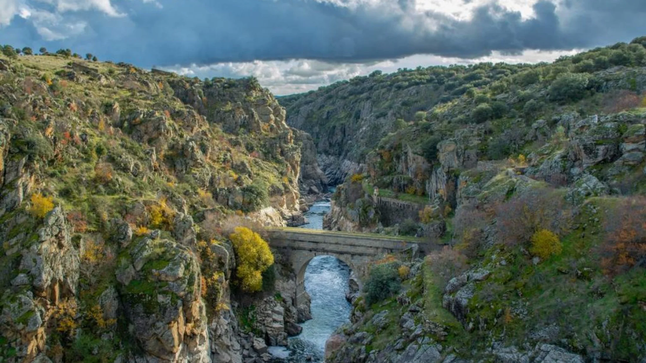
2.Siete Picos (cercedilla/navacerrada): a panoramic ridge you can earn
Siete Picos is a serrated skyline with Madrid to one side and Segovia to the other, reached from Puerto de Navacerrada or Cercedilla. The classic ridge loop packs views, granite tors, and steady ups and downs on pine-needled paths. The wind carries hints of cold rock and resin above the tree line.
- Location: Puerto de Navacerrada or Cercedilla
- Distance/time: 8–12 km, 3–5 h; elevation gain 400–600 m
- Difficulty: Moderate; short rock scrambles near some peaks
- Access: Car via
M-607/M-601(Navacerrada); limited summit parking fills early on weekends - Public transport: Cercanías to Cercedilla, then bus/taxi up to Puerto de Navacerrada; direct interurban buses from
Moncloaalso run on weekends/holidays - Best season: Late spring to autumn; winter requires snow gear and caution
- Ideal for: Day hikes Madrid seekers who want big views without technical climbing
- Price: Free
- Extras: Coffee at Puerto de Navacerrada; link trails toward Collado Ventoso or Fuenfría for longer Guadarrama hikes
Note: Snow and ice persist on shaded slopes; carry microspikes in winter. Source: Comunidad de Madrid mountain safety notes; AEMET seasonal snow advisories.
3.Laguna Grande de Peñalara (puerto de Cotos): high-mountain glacial lake
From Puerto de Cotos, a signed path and stone steps lead to Laguna Grande de Peñalara, a protected glacial cirque at 2,000 m+. The route is short but feels alpine, with dwarf pines, bog boards, and clear rules that keep the ecosystem intact. Cool air smells of wet granite even on sunny days.
- Location: Puerto de Cotos
- Distance/time: ~6 km round trip, 2–3 h; +250–300 m
- Difficulty: Easy–moderate; steady climb on good trails
- Access: Car via
M-607+M-604; parking at Cotos fills early on weekends - Public transport: Interurban bus from
Moncloato Cotos (seasonal schedules); Cercanías to Cercedilla plus bus/taxi as backup - Best season: Late spring to autumn; snow/ice in winter
- Ideal for: Photographers, families used to walking, nature lovers
- Price: Free; no bathing, no off-trail access; dogs on leash only
- Extras: Stop at the Peñalara visitor center; extend to Mirador de la Gitana or Circo de Peñalara if conditions allow
Source: Sierra de Guadarrama National Park—use rules and signage; AEMET mountain forecasts.
4.Embalse de Santillana (manzanares el Real): waterside walking and a castle finish
Gentle tracks fringe the Santillana Reservoir, with La Pedriza’s walls rising behind and water birds cruising the shallows. You can do a full loop (long) or sample short out-and-backs from Manzanares el Real for classic Madrid reservoirs hiking at an easy pace. Reed beds rustle like folded maps in the breeze.
- Location: Manzanares el Real; access points along
M-608 - Distance/time: 5–16 km options, 1.5–5 h; minimal elevation
- Difficulty: Easy; wide paths, family- and stroller-friendly sections
- Access: Car parking in designated pull-offs; avoid soft shoulders and private tracks
- Public transport: Bus
724from Madrid to Manzanares el Real; walk to the shore in 10–20 min - Best season: Autumn–spring; summer mornings to avoid heat
- Ideal for: Family hikes Madrid, birdwatchers, casual walkers
- Price: Free; respect reservoir protection norms (no swimming)
- Extras: Tour the Castillo de los Mendoza; combine with tapas in the plaza
Source: Canal de Isabel II reservoir regulations; SEO/BirdLife regional checklists.
5.Bosque de La Herrería and Silla de Felipe Ii (san Lorenzo de El Escorial): history in the pines
This low-moderate hike links the royal monastery’s grand silhouette with shady oak and pine woods, climbing gently to the Silla de Felipe II viewpoint. Stone seats and lichen-spotted slabs frame a textbook panorama of El Escorial and the Sierra. Warm pine scent mixes with monastery bells on quiet mornings.
- Location: San Lorenzo de El Escorial; start near the monastery or La Herrería parking
- Distance/time: 6–8 km, 2–3 h; +250–350 m
- Difficulty: Easy–moderate; good for mixed groups
- Access: Car via
A-6+M-600; signed parking areas (arrive early on weekends) - Public transport: Cercanías to El Escorial, then local bus or 20–30 min walk to trail start
- Best season: Year-round; spring and autumn for color and clarity
- Ideal for: Families, cultural walkers, photographers
- Price: Free; optional paid monastery visit
- Extras: Visit the Monasterio de El Escorial (UNESCO); cafés and restaurants in the historic center
Source: Ayuntamiento de San Lorenzo de El Escorial trail info; Patrimonio Nacional visitor details.
6.Embalse de Valmayor (valdemorillo/el Escorial): flat lakeside circuits
Valmayor’s broad shorelines and service tracks create easy, mostly flat routes with long sky, silver water, and distant mountain backdrops. Paths vary from compact gravel to earth, making relaxed loops or out-and-backs ideal for families and easy hikes Madrid plans. Egrets lift like scraps of paper from the shallows.
- Location: Valdemorillo, El Escorial, and Colmenarejo margins
- Distance/time: 5–15 km options, 1.5–4 h; negligible elevation
- Difficulty: Easy; some sun exposure—bring hat and water
- Access: Car via
M-505/M-510; park only in signed areas; do not block tracks - Public transport: Interurban buses serve Valdemorillo/El Escorial; short walks to shore
- Best season: Autumn–spring; summer at sunrise/sunset to avoid heat
- Ideal for: Families, beginner runners, birders, dog walkers (leash where signed)
- Price: Free; bathing and motorized boating prohibited (drinking water reservoir)
- Extras: Sunset photography; combine with El Escorial visit or Valdemorillo cafés
Source: Canal de Isabel II reservoir rules; Comunidad de Madrid protected-area guidance.
7.Camino Schmidt (puerto de Navacerrada): a classic contour through black pines
The Camino Schmidt is a beloved traverse from Puerto de Navacerrada to Fuenfría, contouring beneath Siete Picos on soft pine needles. It’s shaded, scenic, and accessible, with options to return the same way or descend to Cercedilla. Resin and cool shade make midsummer steps feel lighter.
- Location: Start at Puerto de Navacerrada; finish at Puerto de la Fuenfría or Cercedilla
- Distance/time: 7–10 km one-way, 2–3.5 h; +/–300 m
- Difficulty: Easy–moderate; steady, well-marked path with some rocky sections
- Access: Car via
M-601; parking limited—arrive early - Public transport: Buses from
Moncloato Navacerrada; Cercanías to Cercedilla for exit - Best season: Late spring to autumn; winter only with proper snow gear
- Ideal for: Groups with varied fitness, shade-seekers, day hikers linking routes
- Price: Free
- Extras: Extend to Miradores de los Poetas in Fuenfría; picnic at Pradera de Navarrulaque
Source: Ruta histórica Camino Schmidt—Federación Madrileña de Montañismo notes; AEMET mountain forecast.
8.Monte de El Pardo: city-edge dehesa and riverside strolls
Just beyond Madrid’s northwestern neighborhoods, El Pardo offers cork oaks, pines, and the quiet Manzanares meanders within a highly protected landscape. Trails are gentle and close to the city, perfect for spontaneous, easy routes after work or a family morning. The earthy smell of dehesa soil rises after even a brief shower.
- Location: El Pardo (Madrid city)
- Distance/time: 4–12 km options, 1–3.5 h; mostly flat
- Difficulty: Easy; wide tracks with some sun exposure
- Access: Car via
M-605; parking at El Pardo village and designated pull-offs - Public transport: Frequent city/interurban buses from
Moncloato El Pardo - Best season: Year-round; spring birdlife and autumn light are standouts
- Ideal for: Families, beginner walkers, photography near Madrid capital
- Price: Free; dogs often required on leash; respect seasonal restrictions
- Extras: Royal Palace of El Pardo exterior; keep a respectful distance from wildlife (deer and boar present)
Source: Parque Regional de la Cuenca Alta del Manzanares management rules; Madrid city environmental notices.
9.Guadarrama River greenway (west): flat, family-friendly fluvial paths
Between Boadilla del Monte and Villaviciosa de Odón, conditioned riverbank paths follow the Guadarrama through poplars and meadows. These near-town, level tracks suit prams, bikes, and easy-paced strolls with cafés never far away. Cottonwood leaves clap softly like hands beside the water.
- Location: West of Madrid—access near Villaviciosa de Odón/Boadilla del Monte
- Distance/time: 5–20 km cumulative options, 1.5–5 h; negligible elevation
- Difficulty: Very easy; fine gravel and dirt paths
- Access: Car via
M-501/M-513; park near signed greenway entries - Public transport: Interurban buses from
Príncipe PíoorAlucheto both towns - Best season: All year; spring shade and autumn colors shine
- Ideal for: Families, learners on bikes, active seniors
- Price: Free
- Extras: Combine with town centers for lunch; bring binoculars for herons and kites
Source: Comunidad de Madrid—Vías Pecuarias and river corridor plans; local council parks info.
10.Cerro de San Pedro (colmenar Viejo/guadalix): short climb, big views
Cerro de San Pedro rises alone like a rounded citadel, giving 360º views with modest effort. The straightforward ascent starts on pastoral tracks before a rockier final push to the summit cairn. Wind brushes the grass in waves as Madrid’s skyline glints far to the south.
- Location: Near Colmenar Viejo/Guadalix de la Sierra; access from
M-608 - Distance/time: ~5.5–6.5 km out-and-back, 2–3 h; +350–450 m
- Difficulty: Easy–moderate; short steep sections near the top
- Access: Car via
M-607+M-608; park in designated lay-bys only - Public transport: Interurban buses to Colmenar/Guadalix; taxi shortens approach
- Best season: Clear days year-round; winter can be windy and cold
- Ideal for: Photographers, sunrise/sunset chasers, quick training climbs
- Price: Free
- Extras: Pair with a stroll in Manzanares el Real or a loop in Dehesa de Colmenar
Source: Sierra Norte de Madrid visitor materials; local hiking topos.
Map and Travel Times
To visualize these day hikes near Madrid under one hour, plot each trailhead with a pin and add estimated driving times from Puerta del Sol and two M-30 junctions, noting peak/weekend variability. Use a simple legend: mountain (Sierra de Guadarrama), pinewoods/dehesa, and reservoirs/river corridors, each with a distinct color. The soft blue of reservoirs and the granite-gray peaks help the eye sort options instantly.
Annotate each pin with: start point name, typical route time and difficulty, parking notes, and nearest public transport. Include plain-text coordinates in the description if helpful, and list primary access roads like M-607, A-6, M-601, and M-608. Remind readers that winter road conditions at high passes can extend travel times beyond an hour; summer Saturday mornings can do the same. For consistency, base times on no-incident traffic and update seasonally.
Practical Tips to Choose Your Route
Start with time and energy, not ambition: match your window to route duration plus 30% buffer for stops, photos, or kids’ pace. If you want views with modest effort, pick Cerro de San Pedro; if you want shade and simple footing, choose El Pardo or Valmayor. Pine shade smells sweeter when you’re not racing the clock.
- Gauge difficulty in plain terms:
- Easy: under 300 m climb, wide paths, little technical terrain (Santillana, Valmayor, El Pardo, Guadarrama greenway).
- Moderate: 300–600 m climb, uneven rock or brief scrambles (La Pedriza variants, Siete Picos ridge, Camino Schmidt, Silla de Felipe II).
- Consider footing, exposure (wind/sun), and altitude.
- Transport choices:
- Car is flexible but parking fills early at Cotos/Navacerrada/La Pedriza; arrive before 9:00 on weekends.
- Public transport works well for Cercedilla, El Escorial, and El Pardo; check
Consorcio Regional de Transportes de Madridtimetables the day before. - For linear routes (Camino Schmidt), plan exit transport or return the same way.
- What to carry:
- Footwear: trail shoes are enough for easy hikes; add ankle support for rocky Guadarrama hikes.
- Water: 1–2 liters per person; more in summer.
- Sun/seasonal gear: hat, sunscreen, wind layer; microspikes in winter if ice persists.
- Navigation: phone with offline map plus a paper backup for ridge routes.
- Reservoirs and protected areas:
- No bathing in drinking reservoirs (Valmayor, Santillana); no fires; drones often restricted.
- Dogs on leash in national/regional parks; always pick up waste.
- Families and dogs:
- Choose loops with shade and regular “milestones” (a viewpoint or stream) to keep kids engaged.
- Early starts avoid crowds and heat; snacks every 60–90 minutes help morale.
- Bring extra water for dogs; rocky granite can heat up—protect paws in summer.
- Crowd-avoidance:
- Go early or late; pick shoulder seasons; choose less-famous segments (e.g., Santillana’s quieter shores on weekdays).
Source: Sierra de Guadarrama National Park rules; Canal de Isabel II reservoir norms; Comunidad de Madrid safety advisories; AEMET forecasts.
Frequently Asked Questions
Before you go, a breeze of cool air through pines can be the nudge to pack light, leave early, and walk smart.
Are these hikes really within an hour of Madrid?
With light traffic, most trailheads here are about 35–60 minutes by car from the M-30. High-mountain passes can take longer on busy winter weekends. Always check live traffic and weather before departure.
Do I need permits or are there restrictions?
La Pedriza vehicle access is limited; the Canto Cochino barrier closes when lots fill. In the National Park (Peñalara, Navacerrada), stay on trails; drones and bathing are prohibited. Dogs must be on leash in protected areas.
Where can I park, and is there a fee?
Parking is typically free but limited at Cotos, Navacerrada, and La Pedriza; arrive early and use only marked areas. Avoid road shoulders that block emergency access. In towns like Manzanares el Real or El Escorial, respect local blue/green zones.
Can I bring my dog?
Yes, on a short leash in parks and reservoirs. Carry water, avoid hot granite midday, and pack out waste. In sensitive bird areas, keep extra distance from the shore.
How do I judge difficulty and time for my group?
Consider elevation gain, surface (rocky vs. smooth), shade, and altitude. As a rule, 3–4 km/h on easy ground and 250–350 m/hour of ascent are reasonable for mixed groups. Add 30–50% time for families with young kids.
Is there phone coverage and are trails well marked?
Coverage is generally good near Madrid, but expect dead zones on north-facing slopes and in valleys. Major routes like Camino Schmidt and Peñalara are well marked; carry an offline map app as backup.
Can I get to these hikes by public transport?
Cercedilla, El Escorial, and El Pardo are the simplest by train/bus. Buses from Moncloa often reach Navacerrada/Cotos on weekends; schedules vary seasonally. Check the Consorcio Regional de Transportes de Madrid the day before.
What about swimming or cooling off in summer?
Swimming is banned in drinking reservoirs such as Valmayor and Santillana. In La Pedriza, many pools are protected—respect signs and choose shaded picnics instead. A hat, early start, and long-sleeve sun shirt go a long way.
Book your experience — discover outdoor activities in Spain with providers verified by Picuco.
Conclusion
When you want nature without the long transfer, these hiking routes near Madrid under one hour deliver: mountain ridges, pine shade, and tranquil shores. You can pick easy hikes Madrid families will love or step up to panoramic Guadarrama hikes that still fit in a day. The scent of resin, the glint of granite, and a cooling evening breeze feel closer than you thought.
Choose one route that matches your time and mood this week—La Pedriza for granite drama, El Pardo for a quick reset, or Peñalara for high-mountain air. Share your favorite day hikes Madrid picks in the comments, and tell us what worked for your group. If you prefer a guide for navigation or safety, look for certified local operators, and explore rural stays near these trailheads on Picuco to turn a day out into a slow weekend.
Save this article for your next change of plans, and check seasonal updates before you go. Madrid’s outdoors is generous; give it an early start, some water, and your attention, and it will give you back a full day of sky.