Congost De Mont-rebei: Why This Gorge Belongs on Your Map
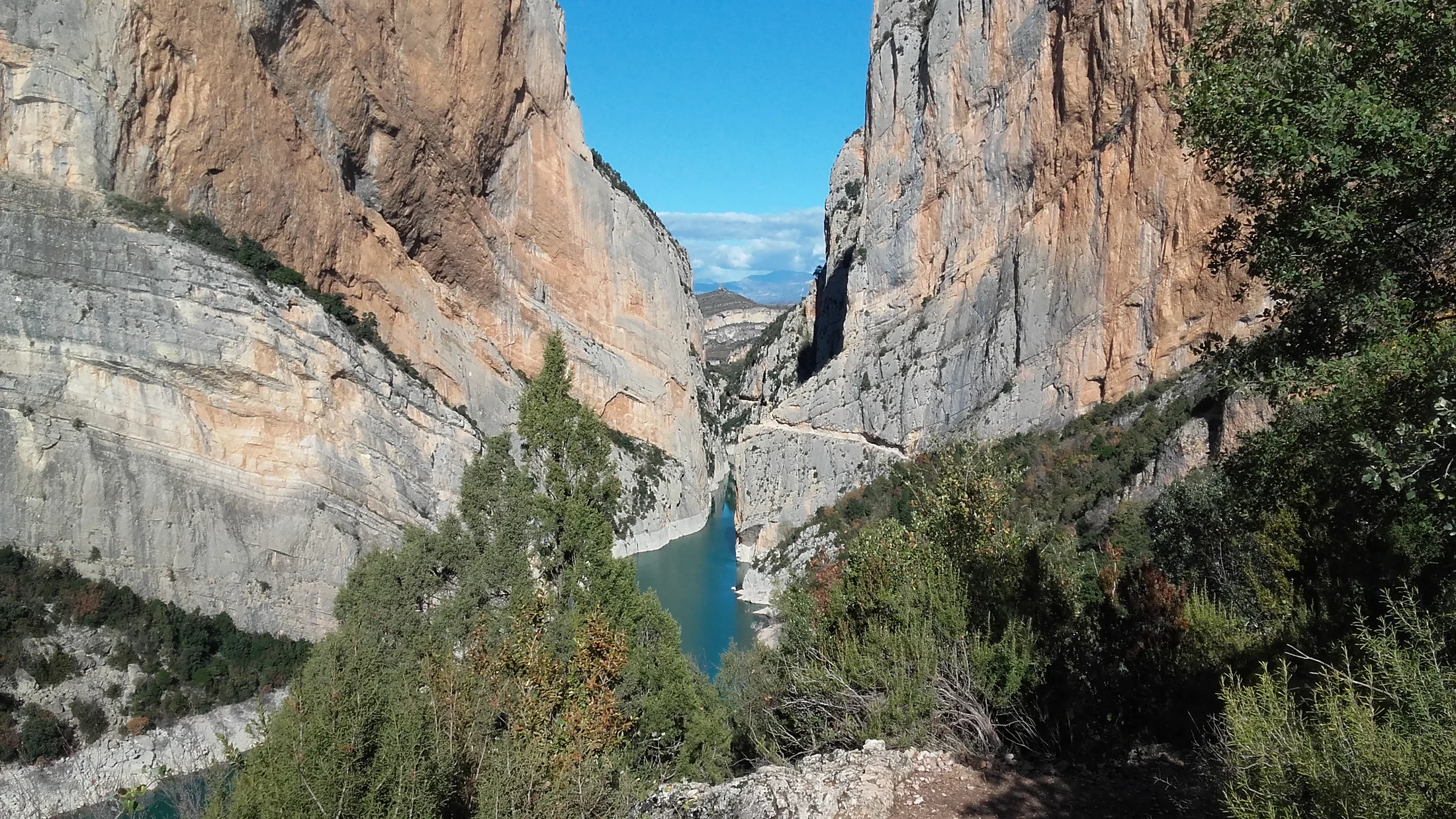
The Congost de Mont-rebei is a rare place where a single path cleaves a wild frontier. Straddling Catalonia (Lleida) and Aragon (Huesca), the Noguera Ribagorçana river carves between the Montsec ranges in a sinuous cut of turquoise water and vertical limestone. You come for the trail cut into the cliff, the Montfalcó walkways, and the Siegué suspension bridge—and you stay for the sense of scale and silence. Start here to plan routes, timings, how to get there, and safe ways to enjoy its best sections. In the still air, the echo of your steps travels the wall like a soft drum.
Landscape, geology and conservation
Congost de Mont-rebei was shaped as the Noguera Ribagorçana sliced through the Montsec d’Ares and Montsec de l’Estall, creating a deep gorge with sheer limestone walls. The main path, excavated into the rock, threads along the Catalan side beneath cliffs that rise several hundred meters. The area is protected on both sides (PEIN/Montsec in Catalonia; protected spaces on the Aragonese side) for raptors like griffon and Egyptian vultures, and for a mosaic of Mediterranean scrub, holm oak, and boxwood. Conservation here matters: it is one of the few large Iberian gorges left without major roads intruding its heart. The Fundació Catalunya La Pedrera and regional administrations maintain paths and signage; pack out all litter and keep voices low to protect nesting birds.
What you’ll get in this guide and how to use it
You’ll find essential logistics (how to get to Montrebei, best seasons and hours), clear access notes from the main roads, and details for La Masieta parking (Catalonia) and Montfalcó (Aragon). We map out the full 16.8 km option, shorter variants, the Montfalcó walkways, and the Siegué bridge, plus services, kayaking, safety tips and FAQs. If you have a half day, jump to the “Short options”; if you’re doing the Montrebei full route, read the “Long route” step-by-step. Download a GPX from official sources before you go, and bring a printed map as backup if coverage drops.
Picuco te puede ayudar
Does something here catch your eye?
Tell us.
Write to us on WhatsApp or email: we answer questions, find the best options and help you sort out the booking.
Essential Information and How to Get There
This gorge sits where two regions meet, so approach depends on which side you choose. You’ll save time by picking a single trailhead—La Masieta for the classic cliff path, Montfalcó for the walkways—and arriving early to avoid parking stress. Plan for heat and crowds in summer; light is kinder near sunrise and sunset. At first light, the water glows jade and the cliffs hold the night’s cool a little longer.
Location, coordinates and best times
- Where it is: On the border between Lleida (Catalonia) and Huesca (Aragon) in the Montsec range, carved by the Noguera Ribagorçana and backed by the Canelles reservoir. The gorge center sits near
42.06°N, 0.66°E(approximate). - Trailheads:
- La Masieta (Catalonia):
42.059°N, 0.673°E(approximate) - Montfalcó (Aragon):
42.064°N, 0.622°E(approximate) - Siegué bridge (mid-route):
42.056°N, 0.648°E(approximate)
- La Masieta (Catalonia):
- When to go: Spring and autumn offer mild temperatures and stable weather. In summer, start at sunrise to dodge heat and foot traffic; in winter, expect shade and cold inside the gorge.
- Best hours: Early morning for cooler shade and calm wind; late afternoon for golden light on west-facing walls. If you’re deciding how to get to Montrebei without crowds, aim to enter the cliff path before 9:00.
Access roads and tracks via the N-260 and local lanes
- From the east (Lleida/Tremp/Àger):
- Use the N-260 or C-13 to Tremp or the C-12 into the Àger valley, then follow local signage toward “Mont-rebei/La Masieta.” Expect narrow paved lanes and short sections with pull-outs for passing.
- From the west (Huesca/Benabarre/Viacamp):
- From the N-230/N-123 junctions near Benabarre, reach Viacamp and continue on a long, signposted unpaved track to Montfalcó. The track is usually passable with a standard car in dry weather; after rains, go slow and watch for ruts.
- Driving notes:
- Allow 30–45 minutes from Àger to La Masieta, and 45–75 minutes from Viacamp to Montfalcó, depending on track conditions.
- GPS sometimes misroutes; follow official brown signs near the final approach.
- Public transport:
- There is no direct bus to either trailhead. Trains/buses reach Tremp, Àger, or Benabarre, but the last kilometers require a taxi or pre-arranged transfer.
Parking and trailheads: La Masieta and Montfalcó
- La Masieta parking (Catalonia):
- Closest car park for the cliff-cut path; limited capacity and highly popular on weekends and holidays.
- In high season, fees or attendants may apply; check the managing foundation’s notices before departure.
- Arrive early (before 9:00) for a spot; shade is limited. Overflow parking along the approach road is often restricted—respect signage to avoid fines.
- Montfalcó parking (Aragon):
- Access via a long unpaved track; fewer cars but slower approach. Good base for the walkways first.
- You’ll find the Montfalcó refuge area nearby; services can be seasonal.
- General advice:
- Do not block farm access or emergency lanes. Leave no valuables in sight; petty theft is rare but possible in remote lots.
- If you plan a one-way hike, arrange a vehicle shuttle in advance or a kayak pickup to return by water.
Where to Stay and What You’ll Find Nearby
Staying close keeps your dawn start feasible and your return unhurried. Àger, Tremp, Camarasa and Viacamp anchor simple hotels, rural homes, and campgrounds, while Montfalcó offers a mountain-refuge style base. After dark, stars spill over Montsec with startling clarity.
Stays in Àger, Tremp and nearby villages
- Good bases:
- Àger (Catalonia): Closest services to La Masieta; small hotels, rural casas, and eateries; about 30–45 minutes to the parking depending on road conditions.
- Tremp (Catalonia): Larger town with supermarkets and a wider lodging range; about 45–60 minutes to La Masieta.
- Camarasa/Balaguer (Catalonia): Useful if combining with other Montsec activities; expect a 60–90 minute drive.
- Viacamp (Aragon): Small base for the Montfalcó side; allow 45–75 minutes due to the unpaved track.
- Booking pointers:
- Weekends in spring/autumn and summer holidays book up quickly; reserve 2–4 weeks ahead.
- Choose lodgings that offer early breakfast or kitchen access if you plan to start at dawn.
- If you’re focused on parking La Masieta at opening time, sleep in Àger or Sant Esteve de la Sarga’s rural lodgings to cut the morning drive.
| Base town | Drive to La Masieta | Drive to Montfalcó | Ideal for |
|---|---|---|---|
| Àger | 30–45 min | 75–95 min | Early starts, services |
| Tremp | 45–60 min | 80–100 min | Larger lodging choice |
| Viacamp | 70–95 min | 45–75 min | Walkways first, Aragon side |
| Camarasa | 60–90 min | 100–120 min | Multi-activity trips |
Times vary with traffic and track conditions; verify locally before you set off.
Camping, designated areas and refuges
- Campgrounds:
- Several campgrounds operate in the Àger valley and around Tremp, with tent pitches, bungalows, and basic shops. Facilities typically include hot showers and laundry.
- Wild camping:
- Dispersed camping is restricted or prohibited in much of Montsec. Always check municipal bylaws and park regulations; fines apply for unauthorized camping or fires.
- Refuges and simple stays:
- Montfalcó refuge offers a mountain-lodge feel on the Aragonese side; services are seasonal and often require reservations.
- Low-impact habits:
- Use stoves instead of fires, pack out all rubbish, and keep noise down near nesting cliffs and farmsteads.
Services and rentals: kayaks, guides and gear
- Kayak rentals:
- Seasonal operators offer Montrebei kayaking on the Canelles reservoir, with common launch points near La Pertusa (Catalan side) and Montfalcó. Expect half-day options and guided outings; confirm prices (often 35–65 € p.p.) with the operator or check options on Picuco.
- Guides:
- Local certified guides run hiking and kayak trips, helpful for first-timers or families. They can also arrange transfers if you hike point-to-point.
- Gear and maps:
- You can buy snacks, water and basic supplies in Àger and Tremp; top up before the trailhead. Carry a paper map and a preloaded GPX—especially if you’re working out how to get to Montrebei via smaller backroads.
Routes and Variants: Plan Your Walk Through the Gorge
You can taste the gorge in two hours or spend a full day threading both sides, depending on time and company. The classic path along the cliff, the Siegué bridge, and the Montfalcó walkways combine into one of Spain’s most spectacular hikes. Under midday sun, the rock radiates stored heat like a warm stove.
1.Long route (16.8 km): step-by-step with key points
The route many call the ruta Montrebei completa links La Masieta, the cliff path, the Siegué bridge, the Montfalcó walkways, and the Montfalcó area before returning. Start at La Masieta and follow waymarks toward the gorge, entering the carved path above the Noguera Ribagorçana. You’ll traverse exposed but well-protected ledges, passing cutouts and viewpoints as the river tightens below.
- Segment breakdown (out-and-back):
- La Masieta to cliff path entrance: 30–45 min on easy track and trail.
- Cliff path to Siegué bridge: 60–90 min with mild ups/downs and narrow ledges.
- Bridge to base of the Montfalcó walkways: 10–15 min; short undulating path.
- Walkways to the higher landing/Montfalcó side: 30–45 min with steep wooden stairs.
- Optional: continue 15–30 min more to the Montfalcó refuge area before turning back.
- Distance/elevation/time:
- 16.8 km total (out-and-back) with roughly 600–800 m cumulative gain; plan 6–7.5 hours at an unhurried pace.
- Logistics:
- Park at La Masieta for the simplest day and return the same way. If you stage cars at both trailheads, you can hike one-way in 4–5 hours and shuttle back.
- Difficulty:
- Moderate for fit hikers; not recommended for those with strong vertigo. The path is narrow in spots, but well-maintained with rails where exposure is highest.
- Water and shade:
- There are no reliable water points on route; carry 2–3 liters per person in warm months. Shade is intermittent; a hat and sunscreen are essential.
- GPX:
- Download a recent GPX from official sources or trusted clubs, and check for temporary closures posted by the managing bodies.
2.Short routes and half-day choices
- La Masieta to the heart of the cliff path (out-and-back):
- A classic taste of Mont-rebei without the walkways. Plan 8–10 km and 3–4 hours total depending on turnaround point. Great first look for families with sure-footed kids.
- Montfalcó walkways and Siegué bridge (out-and-back):
- Start at Montfalcó, descend to the river via the wooden stairs, cross the bridge, take in the cliff path for a short stretch, then return. Expect 5–7 km and 2–3.5 hours; excellent if you mainly want the walkways.
- Viewpoints rather than the full gorge:
- Short hikes to established lookouts on the Catalan side offer big scenery with less exposure, useful for mixed groups or windy days.
- Tip for families:
- Turn back before narrow ledges if anyone feels uneasy. The best days are the ones where everyone wants to come back again.
3.Reverse direction and circular variants
- Going reverse (Montfalcó first):
- Pro: You climb the walkways while fresh and avoid queues on the wooden stairs earlier in the day. Con: The track drive is longer and slower, and the initial exposure comes sooner.
- Circuits and combinations:
- You can combine trail and wider tracks on the Catalan side to form longer loops, but true circular options are limited by the river. Many hikers pair a one-way hike with a pre-booked kayak return.
- Vehicle logistics:
- If you don’t want to retrace steps, leave one car at each trailhead or arrange a pickup. Account for the unpaved approach time to Montfalcó in your day plan.
- Avoiding bottlenecks:
- Start at sunrise or mid-afternoon, let groups pass at pinch points, and keep photo stops quick on the walkways to reduce queues.
Walkways and Singular Spots: Siegué Bridge and Montfalcó’s Wooden Stairs
These are the features most hikers talk about back home. The Siegué bridge hums softly underfoot, and the Montfalcó walkways rise like a staircase stitched to the mountain. Sunlight flickers through timber slats as you climb.
1.Siegué bridge: history, location and photo tips
The puente de Siegué is the slender suspension bridge that links the Catalan cliff path to the Aragonese trail toward Montfalcó. Built to restore foot access across the river after reservoir works transformed the valley, it anchors the mid-point of most hikes. You’ll reach it after the main cliff section from La Masieta or shortly after the first flight of stairs from Montfalcó.
- Where it is: Near
42.056°N, 0.648°E(approximate), spanning the Noguera Ribagorçana between provinces. - How to cross:
- One group at a time when busy; hold the hand cable if you’re unsteady, and don’t bounce or run.
- Photos:
- Frame the bridge with the river bend and cliff walls to show scale; morning light is soft from the Catalan side, afternoon light favors the Aragon side. Keep packs tight so nothing snags on the side cables.
2.Montfalcó walkways: section, condition and safety
The pasarelas de Montfalcó are wooden staircases and platforms bolted into the rock, zigzagging above the water. The timber is periodically maintained; rails and anchors add security, but exposure is real and wind can amplify it. The stair runs are steep; you’ll feel your legs on the way back.
- What to expect:
- Several flights separated by ledges, with narrow passing spots. In high season, short queues form; be patient and give space.
- Safety:
- Wear grippy shoes; avoid the section in storms, strong wind, or when ice is possible. Keep children and dogs under close control; a short lead is essential for pets.
- Photography:
- Step aside at wider platforms to let others pass and to compose safely. A phone wrist strap helps on narrow runs.
3.Viewpoints, tight ledges and the best angles
- Don’t-miss lookouts:
- The classic cut-in-the-cliff section on the Catalan side offers jaw-dropping lines down to the turquoise water. Pause at wider carved benches, never on blind corners.
- Photo advice:
- Include a hiker for scale, and shoot obliquely along the walls to show depth. Midday light flattens color; use early or late hours to bring out the limestone’s textures.
- Safety around drops:
- Clip camera straps, keep one foot stable while leaning, and never step off marked paths for a shot. Drones are typically restricted in protected zones—check regulations before flying.
Recommended Activities Around the Gorge
Hiking is the headline, but water and sky open other ways to experience Montsec. Kayak beneath the walls, watch vultures ride thermals, or end your day with stars above Àger’s astronomy park. At dusk, the cliffs breathe out the heat and a breeze brushes the water.
Hiking: levels, gear and the best picks
- Levels and routes:
- Beginners: Short out-and-back from La Masieta to the first lookouts.
- Intermediates: La Masieta to Siegué bridge and back, or Montfalcó to walkways and return.
- Fit hikers: The full 16.8 km out-and-back linking both sides.
- Gear checklist:
- Trail shoes or boots with grip, 2–3 L of water, sun hat, sunscreen, windbreaker, headlamp if starting at dawn, and a small first-aid kit.
- Smart pacing:
- Breaks at wider ledges keep traffic flowing. In summer, plan shaded rests and keep salt snacks handy to avoid cramps.
- Congost de Mont-rebei specifics:
- Expect narrow sections with rails; nothing technical, but exposure may feel intense for some. Turn back if anyone in your group is uncomfortable.
Kayak and water activities: rentals and put-ins
- Where to launch:
- Common starting points are near La Pertusa (Catalan side) and Montfalcó (Aragonese side), paddling sections of the Canelles reservoir into the gorge.
- Rentals and guides:
- Seasonal outfitters run half-day and full-day outings with all gear included; confirm availability and prices (often 35–65 € p.p.) directly or browse options on Picuco.
- Safety:
- Always wear a PFD, respect reservoir rules set by the Confederación Hidrográfica del Ebro, and watch afternoon winds that can kick up chop in narrow sections.
- Season:
- Spring to early autumn is typical; in drought years, water levels and put-ins change—check conditions a day before.
Photography and wildlife watching
- Light and timing:
- Golden hour lights the walls; blue hour adds calm reflections if winds are low. Inside the gorge, shade is deep—bump ISO and keep a steady hand.
- Species to look for:
- Griffon and Egyptian vultures, choughs, and occasional bearded vulture overhead; rosemary and juniper along sun-baked ledges.
- Ethics:
- Keep 30–50 m from nests, never bait or call birds, and mute camera beeps. Binoculars (8x–10x) and a 200–400 mm lens suit most sightings.
Other activities: climbing, Mtb and cultural stops
- Climbing:
- The Montsec region hosts limestone sectors, but restrictions protect nesting raptors; check local topos and seasonal bans before you go.
- MTB:
- Ride outside the narrow gorge paths; wider tracks in the Àger valley and along reservoir roads offer scenic loops.
- Culture:
- Visit Àger’s collegiate church or the Parc Astronòmic del Montsec for night sky sessions. Small museums in Tremp and Benabarre add context to the landscape and its communities.
Practical Tips, Safety and Faqs
A little planning turns a beautiful place into a smooth day. Pack smart, start early, and treat the gorge as both trail and habitat. At noon, the cliff-cut path can feel like a stone oven—respect your limits and those of your group.
Practical tips and safety measures
- Timing and weather:
- Start at sunrise in summer; in autumn/winter bring a warm layer for the shaded gorge. Avoid strong-wind days for the walkways.
- What to carry:
- 2–3 L of water per person, snacks, hat, sunscreen, grippy footwear, a small first-aid kit, and a printed map plus GPX backup.
- Route and conditions:
- Check notices from Fundació Catalunya La Pedrera (Catalonia) and Aragon’s environment services for temporary closures or maintenance on the pasarelas de Montfalcó.
- Parking strategy:
- For parking La Masieta on busy weekends, arrive before 9:00 or choose a weekday. Never park outside marked areas; towing and fines happen in peak season.
- On exposed sections:
- Walk single file, use rails where provided, and step aside at wider bays for photo stops. If you suffer from vertigo, assess the first narrow ledges and decide early.
- With kids and dogs:
- Keep children within arm’s reach on ledges. Dogs must be leashed and are not advised on the steep walkways if they panic on open stairs.
- Emergencies:
- Coverage is patchy; carry a charged phone and offline maps. In Spain, dial 112 for mountain rescue and be ready to relay location coordinates.
Frequently asked questions
Do I need a permit to visit Congost de Mont-rebei?
No permit is required for day hiking, but group size and activity rules apply in protected zones. Check current regulations with local authorities before organizing large groups or special activities.
Are there toilets at the trailheads?
Facilities vary by season and location. La Masieta sometimes has basic services in peak months; Montfalcó facilities are linked to the refuge area. Do not rely on on-route toilets—plan accordingly.
Can I hike with my dog?
Yes, but dogs must be on a leash and should avoid the steep, open-tread walkways if they are nervous on stairs. Bring extra water for pets, and keep clear of cliff edges and nesting areas.
When is the best time of year to go?
Spring and autumn balance temperature, light, and crowd levels. Summer is possible with an early start; winter offers solitude but colder, shaded conditions and shorter days.
Where exactly is the Siegué bridge?
It spans the river roughly mid-route near 42.056°N, 0.648°E (approximate). From La Masieta, you reach it after the main cliff section; from Montfalcó, it’s just beyond the lower walkway flights.
Is the route suitable for people with vertigo or young children?
Parts of the path are narrow and exposed, with rails for protection. If vertigo is severe, consider a short approach to wide viewpoints and turn back before the tighter ledges; families should choose the shorter variants.
Book your experience — discover active nature experiences in Spain with Picuco-verified providers.
Conclusion
Congost de Mont-rebei rewards care and curiosity: choose your side, start early, carry water, and let the gorge’s quiet do the rest. Whether you tackle the 16.8 km link-up or a short out-and-back, the cliff path, the Siegué bridge, and the Montfalcó walkways deliver a day you’ll talk about for years. Save a GPX to your phone, reserve a nearby stay if you plan a dawn start, and share your route and timing with someone at home. If you want to add a guided hike or kayak return, explore options through Picuco and plan your logistics in one go. Step lightly, look up often, and wave to the vultures riding the thermals above.