Valle Del Jerte in Bloom: Why This Spring Spectacle Is Worth Planning
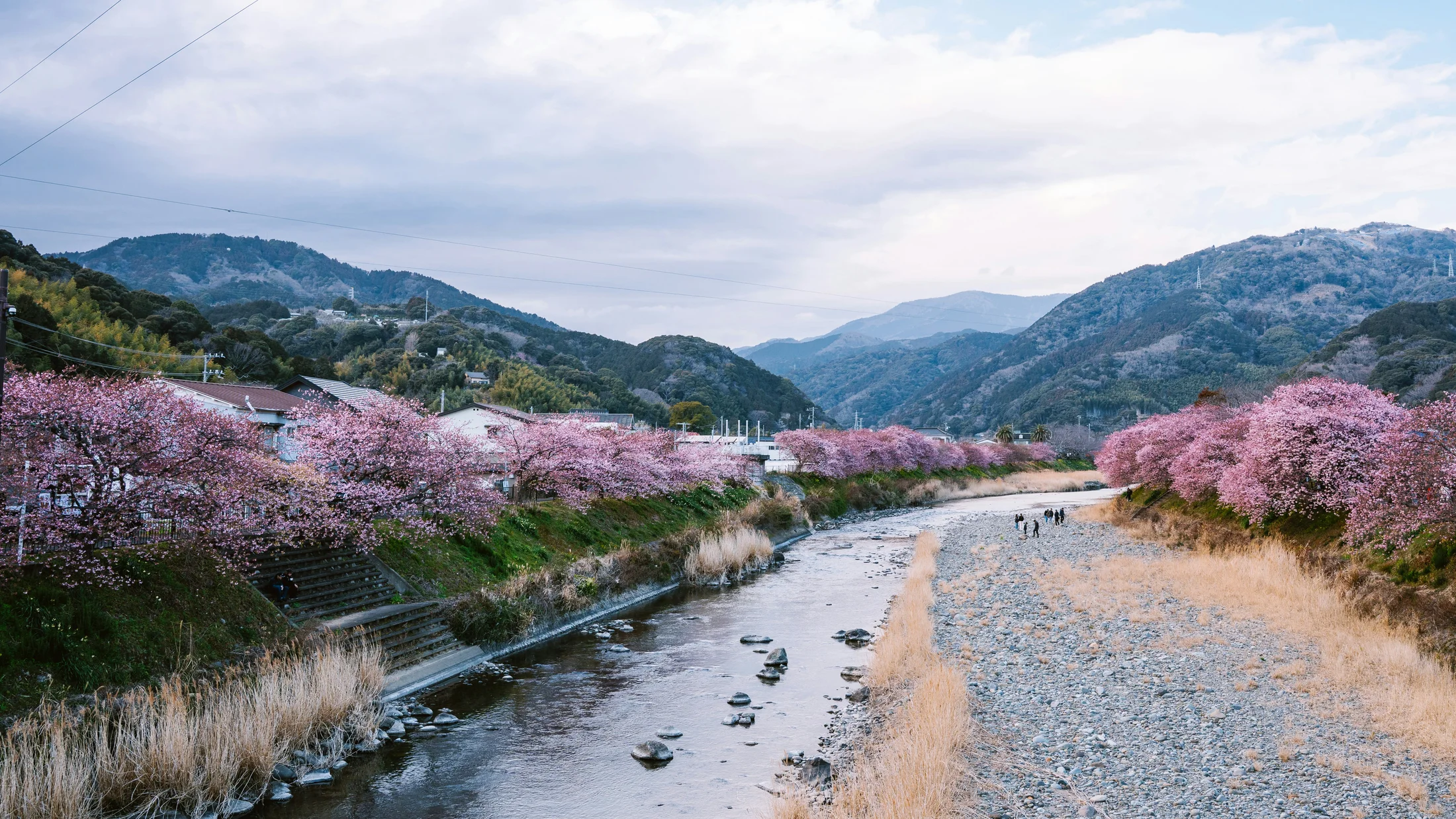
The Valle del Jerte in bloom turns a mountain valley into a white sea each spring. Spreading along terraced hillsides in northern Cáceres, Extremadura, over a million cherry trees transform 11 villages into a living festival that is cultural, agricultural, and wildly photogenic. For locals, cherry farming on stone-walled terraces is centuries-old work; for visitors, it’s a short, radiant window of beauty that supports family economies and brings careful tourism to the valley.
What makes this bloom special is its scale, timing, and community. Orchard belts run from the river floor up to high slopes, so the cherry blossom in Valle del Jerte unfurls in waves from low to high altitude. The Fiesta del Cerezo en Flor, recognized as a Festival of National Tourist Interest in Spain, anchors the season with events that celebrate pruning traditions, terrace culture, and the harvest to come. You’ll feel spring on your skin as cool air carries a faint honeyed scent through the orchards.
You’re reading a complete, practical guide to plan the visit without guesswork. You’ll find: when the blossom usually peaks and how to predict exact dates in a given year; how to reach the valley and move around; where to stay according to your style and budget; three curated route types (by car, on foot, and by mountain bike) with viewpoints and logistics; the key Jerte towns to visit; and a deep dive into the Garganta de los Infiernos natural reserve, its pools, and the best scenic overlooks. Use it like a map: start with timing, then choose your base, then pick one route and two to three villages for a balanced day.
Plan a weekday if you can, arrive early, and respect farms and footpaths; this spectacle exists thanks to generations who keep terraces, canals, and trees alive. If cherry petals start to fall, don’t worry—“petal rain” is one of the valley’s most poetic moments, and pathways flutter like a shaken snow globe for a few days. With the sections below, you can go straight to the details you need and shape an escape that fits couples, families, or friends traveling together.
Picuco te puede ayudar
Does something here catch your eye?
Tell us.
Write to us on WhatsApp or email: we answer questions, find the best options and help you sort out the booking.
When to Go and How to Get There: Essential Facts for the Bloom
Timing the Valle del Jerte in bloom is about altitude and temperature, not the calendar alone. The valley stretches along the N‑110 corridor between 400–1,300 meters, bordered by the Sierra de Tormantos and Sierra de Gredos, which create marked microclimates. Warmer, lower villages flower first; higher terraces and upland towns bloom later. On a mild year, you can watch the bloom climb the slopes like a slow wave. At dawn, orchards glow pearl-white as a thin mist lifts from irrigation channels.
A typical bloom window runs late March to early April, but it may shift:
- Early bloom (mid–late March): after a warm, dry winter.
- Peak bloom (roughly 7–10 days): when most bands of altitude pop at once.
- Petal fall (3–5 days): “lluvia de pétalos,” when petals drift and ground turns white.
- Late bloom (early–mid April): higher belts near Piornal and El Torno often lag a week.
Three variables push dates earlier or later:
- Winter chill hours: trees need cold to set buds; too few shifts bloom later and unevenly.
- Late frosts: cold snaps can pause or damage lower belts, making higher zones the best bet.
- Rain and wind: heavy rain can shorten petal fall; wind may strip exposed hillsides sooner.
To predict exactly when to see cherry blossoms in Spain here, rely on real-time local sources:
- Official channels: Turismo Valle del Jerte (social feeds announce zones in bloom daily).
- Agricultural cooperatives: they post orchard-stage updates across altitude bands.
- Local webcams and community photos: check village accounts for “on-the-ground” views.
- Visitor centers: the Garganta de los Infiernos interpretation center shares practical advice.
Where is the valley? It sits in northern Extremadura, Cáceres province, anchored by Plasencia 20–30 minutes away. The N‑110 road runs through the heart of the valley from south (near Plasencia) to north (Tornavacas, pass toward Ávila). This spine makes moving between bloom zones straightforward. The river Jerte parallels the route, and terrace roads climb toward upland villages with panoramic overlooks.
How to get there:
- By car
- From Madrid: 2.5–3 hours via A‑5 to Plasencia, then N‑110 north into the valley.
- From Salamanca: 1.5–2 hours via A‑66 to Plasencia, then N‑110.
- From Cáceres: about 1–1.5 hours via A‑66 to Plasencia, then N‑110.
- Best practice: arrive early (before 10:00) on weekends; parking fills near hotspots.
- By public transport
- Long-distance buses connect Madrid/Cáceres/Salamanca with Plasencia.
- Regional buses run from Plasencia to towns like Cabezuela del Valle, Jerte, and Tornavacas (spring schedules often add services on peak days).
- Trains serve Plasencia from Madrid and Extremadura hubs; combine with bus or taxi to reach villages.
- Nearest major airports
- Madrid (Adolfo Suárez–Barajas): widest choices; plan a 2.5–3-hour drive.
- Salamanca and Badajoz airports: limited flights; 2–3 hours by road to the valley.
What to pack and expect:
- Footwear: waterproof shoes for orchard tracks; trails can be damp after irrigation.
- Layers: mornings are crisp even in sunshine; wind bites on exposed viewpoints.
- Navigation: download offline maps; mountain valleys can drop signal in gullies.
- Parking: follow temporary signs; some villages habilitate seasonal lots in fields with attendants.
- Respect: orchards are private farms; use signed paths and edges only.
Reading the bloom in real time:
- Watch official posts each morning; they name specific hamlets and slopes where blossom is at 70–100%.
- Check altitude: if Navaconcejo is peaking, expect Piornal/El Torno to peak 5–10 days later.
- Use viewpoints like Puerto de Tornavacas to scan belts; white swaths tell you where to go first.
- Build a two-day plan: day 1 lower/middle valley, day 2 higher terraces to catch the rolling peak.
The valley’s communities work year-round to maintain terrace walls and irrigation ditches (acequias). Treat gates, walls, and channels like someone’s workshop, and you’ll help keep the bloom open and welcoming for everyone who follows you.
Where to Stay and How to Visit Without Stress
If you plan the Valle del Jerte in bloom on a weekend, lodging can sell out weeks ahead. Choose your base by what you value most—viewpoints, quiet, or being in the middle of the Fiesta del Cerezo en Flor. In the evening, the scent of woodsmoke drifts through stone alleys while the hills fade from white to blue.
Main lodging types:
- Rural houses and apartments: best for families/groups, kitchen access, often in orchard belts.
- Small hotels and guesthouses: comfort, breakfast included, village-center convenience.
- Farm stays and agrotourism: stay on working farms; ask about blossom-safe access paths.
- Campsites and bungalows: budget-friendly, river access; some open seasonally.
Best zones by priority:
- For viewpoints at your door: El Torno (west-facing balconies), Piornal (highest terraces), Tornavacas (near the pass).
- For being “in the bloom”: Navaconcejo and Cabezuela del Valle hug dense orchard belts.
- For Fiesta atmosphere and services: Cabezuela del Valle and Jerte often host events and have more dining options.
- For logistics with public transport: villages along the N‑110 (Jerte, Cabezuela del Valle, Navaconcejo) offer easier bus connections.
Booking smart in high season:
- Reserve 4–6 weeks ahead for late March/early April weekends.
- Consider Sunday–Tuesday stays; blossom is the same with fewer crowds and better rates.
- Choose flexible rates; sudden heat or cold can nudge bloom dates by a week either way.
- Ask hosts about walking access to orchards and current best viewpoints at check-in.
Parking and access:
- Park only where signed; temporary field lots often support community groups and reduce roadside chaos.
- Avoid blocking farm lanes; tractors move at dawn and dusk during pruning and irrigation.
- Expect occasional “one-way” traffic plans or escorts on the busiest days; follow local volunteers’ directions.
Photography, drones, and etiquette:
- Tripods: fine on public tracks; don’t step into planted rows to compose shots.
- Drones: Spain’s rules require pilot registration and insurance; no flights over crowds, roads, or within protected areas without permits. Parts of the valley border regulated airspace—check the national map (ENAIRE Drones) and ask the natural reserve for rules.
- Dawn/late-afternoon shoots: softer light, fewer people; mid-day glare washes out white petals.
Sustainability practices that matter here:
- Stay on signed trails; terrace walls are fragile and costly to repair.
- Do not pick blossoms or cross wire lines; each flower is a future cherry.
- Carry-in, carry-out waste; bins overflow on peak weekends.
- Support village bakeries and bars; you help keep services open year-round.
If you want quiet nights and quick dawn access to slopes, choose upland villages; if you prefer café life and Fiesta events at your doorstep, base yourself along the river towns. Either way, let your host’s local knowledge guide your first morning’s plan; they often know which hillside turned white last night.
Routes That Make the Most of the Bloom
You can experience the Jerte Valley routes three ways: panoramic drives, short and long walks, and BTT (mountain bike) loops. Choose one per day; mixing all three in a single day creates more time in traffic than under trees. On calm mornings, petals tremble like snowflakes while a thrush sings from a stone wall.
By car: a panoramic loop of orchards and viewpoints
This classic car route strings together the valley’s best “big-picture” views with short strolls. Start at Puerto de Tornavacas, the northern gateway, where a lay-by just below the pass gives a sweeping, amphitheater-like view of blossom belts. Early morning light slants across terraces, and the pass stays quieter before 10:00.
Follow the N‑110 south and stop in Tornavacas to stretch and photograph streets hung with geraniums; continue to Jerte for a coffee break and a detour to the Garganta de los Infiernos visitor center to ask about the “Los Pilones” path conditions. Return to N‑110 and roll into Cabezuela del Valle; use the signposted municipal lots rather than circling the historic core. Wander the arcaded main street, then drive a few minutes to a signed hillside turnout for elevated photos of the town over orchards.
Continue south to Navaconcejo for riverbank views and the short walk to the first Nogaledas waterfalls if time allows. Then climb toward El Torno on the signed local road; its balcony-like viewpoint faces the full valley. Finish by looping to Piornal (highest town) for late-blooming terraces and broad panoramas before descending to Valdastillas and rejoining the N‑110.
Practical tips for this ruta cerezos Valle del Jerte:
- Duration: 4–6 hours with short walks and café stops.
- Parking: use temporary spring lots and marked pull-outs; never on blind curves.
- Crowds: drive the loop counterclockwise on weekends to avoid bottlenecks in historic centers.
- Combine with: a 60–90-minute stroll at Los Pilones or Nogaledas for a “car + foot” day.
On foot: short and long trails with dense blossom
Walking puts you at eye-level with petals and terrace craft, and several signed paths thread through or alongside cherry belts. “PR” routes are short-distance trails; you’ll see yellow-and-white paint marks. On breezy afternoons, petals skitter along the path like foam on a stream.
Short options (1.5–3 hours):
- Los Pilones (Garganta de los Infiernos): 6–7 km round-trip, 250–300 m gain, easy-moderate. Start at the reserve’s visitor center near Jerte. Best for mixing blossom panoramas with smooth “pothole” pools in granite. Early or late avoids crowds.
- Nogaledas waterfalls (Navaconcejo): 6–7 km loop, 350–450 m gain, moderate. Trail climbs alongside a sequenced stream with multiple falls; cherry belts drape the lower slopes and offer strong “cerezos en flor Valle del Jerte” frames against moving water.
Longer options (4–6 hours):
- Cabezuela del Valle terraces and El Reboldo: 12–14 km, 500–700 m gain, moderate. Start in Cabezuela, climb through blossom belts to the El Reboldo area for broad views, then contour across to secondary tracks and descend by a different spur.
- Section of the historic Carlos V route (between Tornavacas and high terraces): 10–12 km there-and-back, 600–800 m gain, moderate-strenuous. Mixs beech/oak with upper-orchard edges; higher belts bloom later and suit second-week visits.
Trail tips:
- Footwear: grippy soles—granite and irrigation drips can slick rocks.
- Safety: terraces have unguarded edges; keep children on the uphill side.
- Etiquette: stay on paths or track edges; orchard rows are private and fragile.
- Photo advice: low angle through foreground blossoms will frame villages and ridgelines.
Btt: flowing tracks between villages and terrace rims
BTT is the Spanish term for mountain biking; valley tracks and old farm lanes form a scenic network that ties villages and blossom belts together. Respect hikers on shared paths; ring or call early, slow wide, and yield when needed. Cool morning air carries a damp mineral smell from irrigation rills as tires hum over packed earth.
Suggested rides:
- Family/intro: River-floor greenway between Navaconcejo and Cabezuela del Valle, 16–20 km out-and-back, mostly flat on mixed surface (paved lanes and dirt). Ideal for seeing low-belt blossom with café stops at both ends. Park in municipal lots and avoid main-road shoulders.
- Intermediate loop: Jerte – Los Pilones balcony – Cabezuela – Jerte, 28–32 km, 700–900 m gain. Climbs to panoramic track segments skirting the Garganta de los Infiernos reserve boundary, then rolls through mid-slope orchard lanes. Technical spots: short rocky ramps; walk if unsure.
- Advanced high loop: Jerte – Piornal – Valdastillas – Jerte, 40–50 km, 1,200–1,600 m gain. Big views, cooler air, and later-blooming belts. Long, steady climbs on asphalted farm roads and gravel, with fast descents. Check brakes and carry lights for tunnels/shaded gullies.
Logistics:
- Start early; spring weekends get busy after 10:00.
- Services: water at village fountains, snacks in bakeries; carry spares (tubes, chain link).
- Bike storage: many rural stays offer courtyards or sheds—ask in advance.
- Charging: e-bike charging is easiest at your lodging; cafés may allow a top-up—consume and ask politely.
- Drone note: no drone flights from the saddle—Spain’s rules require line-of-sight and safe, stationary piloting.
If you want to weave blossom photography into a bike day, plan short spur hikes from bike racks at village squares; a cable lock and bright vest make quick stops safer and more efficient during peak traffic.
Villages You Should Not Miss During the Bloom
The pueblos Valle del Jerte are distinct, and each gives you a different angle on the bloom. Choose two or three per day and let the valley’s rhythm guide you. In late afternoon, wooden balconies throw patterned shadows across cobbled lanes while distant terraces glow like frosted tiers.
Navaconcejo: heart of the blossom and river walks
Navaconcejo sits along one of the densest orchard belts, making it a favorite base when the middle valley peaks. The riverside promenade and short access to the Nogaledas waterfalls keep families happy while photographers work early and late light from nearby lanes. After rain, the waterfalls throw mist that catches petal drift.
What to see and do:
- River walk and pedestrian bridge: calm views up and down valley with blossom on both slopes.
- Historic alleys near the church: whitewash and wooden balconies frame glimpses of orchard bands beyond.
- Nogaledas waterfalls: the first cascade is a quick reach for a short, kid-friendly outing.
Where to find the best blossom:
- Immediate hills just above town in both directions; ask the tourist office or local bar for which side is “whiter” today.
- Lower terrace roads toward Cabezuela offer layered views with the river foreground.
Services and planning:
- Good range of cafés, bakeries, and small markets.
- Parking: use signed lots outside the compact center on spring weekends.
- Combine with Cabezuela del Valle or Valdastillas the same day; both are under 15 minutes’ drive.
Cabezuela del Valle: historic core and high balconies
Cabezuela del Valle has one of the best-preserved historic centers in the valley, with arcaded streets, wooden eaves, and a lived-in feel. From here, short climbs reach balconies that look across to white-swept slopes and the meander of the river. At siesta, shutters half-close and the scent of coffee mixes with damp stone after irrigation.
What to see and do:
- Historic quarter: stroll the arcades, find narrow lanes that suddenly open to blossom views.
- Local museum/interpretation spaces (when open): context on terrace building and cherry culture.
- Short balcony walks: signed tracks lead to viewpoints just outside the core.
Where to find the best blossom:
- Mid-slope belts immediately above the town deliver “cerezos en flor Valle del Jerte” images with rooftops below and ridgelines beyond.
- Edges of the road toward Jerte provide quick pull-outs for layered shots.
Services and planning:
- Several restaurants and bars, spring weekend events during Fiesta del Cerezo en Flor.
- Guided visits sometimes run during peak season; check the village’s tourism channels upon arrival.
- Parking can be tight—choose the municipal lots indicated as you enter from N‑110.
Jerte: namesake village and trailhead hub
Jerte gives its name to the valley and serves as a pivot for trails into the Garganta de los Infiernos natural reserve. It’s a practical base for mixing blossom with short hikes, especially the Los Pilones path. In the evening, the river chatters through town while swallows loop under stone bridges.
What to see and do:
- Old bridge and riverside: classic frames with blossom bands rising behind.
- Visitor center for the Garganta de los Infiernos: staff provide trail status and conservation updates.
- Short detours to orchard lanes west of town for late-afternoon photos.
Where to find the best blossom:
- Slope roads in the direction of Cabezuela often carry strong mid-slope bands.
- Higher tracks toward the reserve boundary give “valley-wide” views above orchard crowns.
Services and planning:
- Solid mix of cafés and small groceries; spring Saturdays may host events.
- Parking: follow signs to seasonal lots, especially if hiking Los Pilones.
- Combine with Tornavacas (north) or Cabezuela (south) the same day for varied angles.
El Torno: balcony over the valley and traditional landscape
El Torno perches high on the west side and feels like a balcony facing the entire valley, which makes it superb for wide, layered photographs. Its viewpoint area looks across to the opposite slopes and down the river corridor with white bands stacked like contour lines. On windy evenings, the ridge carries the resinous scent of pines above the terraces.
What to see and do:
- The main viewpoint above the village: sweeping east-facing frames of orchard mosaics.
- Quiet lanes with stonework and small plots—good for understanding terrace scale and care.
- Short strolls on local roads contouring the slope; respect private field entrances.
Where to find the best blossom:
- Terraces immediately below the village for close-up petal textures.
- Morning visits work best here for front-lit imagery across the valley.
Services and planning:
- A couple of bars and small shops; confirm spring hours midweek.
- Parking: limited near the viewpoint; use signed spots in the village and walk 5–10 minutes.
- Combine with Piornal for a “high belts” day; their bloom phases often complement each other.
Piornal: highest village and grandstand views
At roughly 1,175 meters, Piornal is the highest village in Extremadura, and altitude shapes both its climate and its bloom. Blossom here usually lags lower towns by a week or more, which is handy if you miss the first peak. Air feels noticeably cooler, and the horizon opens wide with distant lines of white fields. In late light, petals gleam like frost on the uppermost terraces.
What to see and do:
- Panoramic points along entrances to the village for valley-long frames.
- Nearby waterfalls like Caozo (short drive/walk) combine moving water and blossom when flow is safe.
- Quiet loops on farm roads bordering orchard edges—always keep to the roadbed.
Where to find the best blossom:
- High belts around the town’s perimeter; check which aspects turned white that morning.
- Afternoon offers softer light here; mornings can be bracingly cool.
Services and planning:
- Bars and bakeries; limited but sufficient for a snack-based day.
- Roads up can be narrow; drive patiently and give way on tight curves.
- Combine with Valdastillas and El Torno to track the bloom’s uphill progression.
Tornavacas: northern gateway and route crossroads
Tornavacas guards the northern entrance at the foot of the pass toward Ávila, making it perfect for sweeping “from above” perspectives and for connecting to long-distance routes like the historic Carlos V way. In early morning, clouds hang low above the pass as the valley opens in a white fan below.
What to see and do:
- Old quarter and river bridge: classic architecture with orchard views.
- Puerto de Tornavacas viewpoint: the essential overlook to read which belts are peaking.
- Access to paths climbing toward the pass for high-scope photography.
Where to find the best blossom:
- Slopes just below the viewpoint deliver valley-spanning images.
- Terrace bands south of town often light up early in the bloom wave.
Services and planning:
- Several cafés; last good stop before crossing the pass toward Ávila.
- Parking: use signed areas near the entrance to the historic quarter.
- Combine with Jerte and Puerto de Tornavacas at dawn, then drop to middle-valley towns as crowds build.
Natural Highlights: Garganta De Los Infiernos, Pools, and Panoramic Points
Beyond orchards, the valley’s protected landscapes add texture to a blossom visit: granite gorges, smooth pothole pools, and balcony-like viewpoints. Water, rock, and bloom make strong contrasts on camera and in memory. In the gorge, the sound of rushing water is a steady undertone as petals circle in eddies.
Garganta de los Infiernos: trails, Natural pools, and rules
The Garganta de los Infiernos Natural Reserve protects a sculpted granite gorge, mixed forests, and emblematic “marmitas” (potholes) at Los Pilones. Main routes are well-signed, and the visitor center near Jerte offers maps and updates. In spring, flows can be strong; pools glitter green while foam threads through channels.
Key routes:
- Los Pilones out-and-back: 6–7 km, 250–300 m gain, easy-moderate. Family-friendly with care near water; stone slabs can be slick.
- Extended loop to higher viewpoints: 10–12 km, 500–600 m gain, moderate. Adds ridge outlooks across the valley, mixing forest and blossom vistas.
Access and parking:
- Use reserve parking at the visitor center or signed overspill areas on peak days.
- No off-road parking; roadside stops in narrow sections are dangerous and fined.
Regulations and safety:
- This is a protected area; stay on trails, no fires, pack out waste.
- Swimming: permitted in summer at signed spots when flows subside; spring waters are cold and currents can be deceptive—assess carefully and avoid risky entries.
- Drones: prohibited without express authorization within the reserve; check with staff for current rules.
Respect for this space is non-negotiable; the reserve’s health underpins the valley’s water and farming rhythms just as much as it frames your photos.
Pools and river beaches: best spots and precautions
The valley offers natural pools and river beaches that are perfect for summer, and photogenic in spring. Depth, flow, and rock conditions vary widely; a calm surface can hide strong undertows after rains. The scent of wet granite rises when sun warms the rocks after a shower.
Well-known areas:
- Los Pilones (in the reserve): iconic smooth channels; spring visits are for photos and picnics above the waterline—avoid bathing when flows are high.
- La Pesquerona (Navaconcejo): a popular summer river beach with calm sections; in spring, use upper banks to frame blossom on nearby slopes.
- La Isla (Cabezuela del Valle): grassy banks and stepping stones, good for family photos with orchard backdrops.
- Charcos near Jerte: smaller pools downstream of bridges can be calmer late in spring.
Precautions:
- Check depth and flow before any entry; cold shock is real in mountain rivers.
- Wear grippy footwear; polished granite is slippery when wet.
- Keep an eye on kids; eddies and drop-offs can surprise even in clear water.
Photo and conservation tips:
- Golden hour adds contrast to white petals; place water textures in the lower third for balance.
- Never use soap/shampoo in natural pools.
- Avoid trampling riparian plants; they stabilize banks during floods.
Viewpoints and panorama spots: where to photograph the valley
The best photography spots are about orientation, light, and altitude contrast. For blossom, you want oblique angles that layer white belts with towns and ridgelines. In late light, tiles glint on rooftops while orchards lift like white ruffles against the darker slopes.
Effective viewpoints:
- Puerto de Tornavacas: grand overview; dawn and early morning sidelight the terraces.
- El Torno main balcony: east-facing—best from sunrise to mid-morning for full-valley frames.
- Upper lanes above Cabezuela del Valle: quick to reach, ideal for wide shots with the historic core below.
- Piornal edges: long, cooler views over late-blooming belts; afternoons soften contrast.
Tips to avoid crowds in shots:
- Shoot early or late; step 5–10 minutes along a lane from main pull-outs.
- Use a short telephoto (50–85 mm) to compress terrace layers into a pleasing pattern.
- Compose with a foreground branch in bloom to add depth; focus on the blossom, not the village.
Drone use:
- If you have permits and fly outside protected/restricted zones, launch from quiet, open ground away from people and roads.
- Maintain line-of-sight, respect privacy over farms and homes, and land at the first sign of gusts.
Bring patience and a cloth for your lens; petals and mist are part of the magic and the mess.
Frequently Asked Questions About the Bloom
When do the cherry trees bloom in the Valle del Jerte, and how can I predict the dates?
The Valle del Jerte in bloom typically spans late March to early April, but exact dates shift with weather and altitude. Lower towns (Navaconcejo, Cabezuela) open first, and higher belts (El Torno, Piornal) can lag by 7–10 days. After warm winters, bloom can begin a week early; a late frost can stall or stagger lower slopes, pushing the best views uphill. To predict “when to see cherry blossoms” each year, combine sources: daily updates from Turismo Valle del Jerte, cooperative notes on bud stages, and webcams or photos shared by village accounts. At the start of your week, anchor plans around whichever altitude band shows 70–100% bloom; if petals are falling below, aim one or two belts higher for fresher blossom. A two-day trip usually catches at least one zone at or near peak.
What is the best time of day to photograph the blossom?
Golden hours—first two hours after sunrise and last two before sunset—are ideal for cherry blossom Valle del Jerte shots. Low-angle light adds warmth and texture to white petals, and terraces gain depth. At dawn, haze often lifts from the river, while evening softens ridgeline contrasts. Midday flattens whites and deepens shadows; use partial shade or backlight through petals to avoid harshness if you must shoot then. Bring a polarizing filter to control glare, and consider a short telephoto (50–85 mm) to compress terrace layers. To avoid crowds in frames, step 5–10 minutes off main pull-outs onto signed lanes or viewpoint spurs. For a plan: dawn at Puerto de Tornavacas, mid-morning in orchards above Cabezuela, and late light at El Torno or Piornal.
Do I need any permits to visit the Garganta de los Infiernos or to fly drones?
No permit is required to hike signed trails in the Garganta de los Infiernos Natural Reserve, but regulations apply: stay on paths, no fires, pack out waste, and respect seasonal safety advice around pools. Organized groups may need prior notice—confirm at the visitor center. Drones follow Spain’s national rules: pilot registration and insurance, no flights over crowds or roads, maintain line-of-sight, and comply with local restrictions. Within the reserve, drones are prohibited without explicit authorization due to wildlife and visitor safety. Outside protected zones, check the national airspace map (ENAIRE Drones) for restrictions, and always avoid overflying private orchards and village centers. When in doubt, ask at a tourist office or the reserve’s staff before launching.
What public transport options exist during the bloom?
Public transport to the valley is workable if you base in N‑110 towns. Long-distance buses and regional services connect Madrid, Cáceres, and Salamanca to Plasencia, which functions as the gateway. From Plasencia, spring bus schedules usually add runs to Jerte, Cabezuela del Valle, Navaconcejo, and Tornavacas; check timetables the week you travel, as extra services often appear on peak bloom weekends. Trains serve Plasencia from Madrid and Extremadura hubs, and a bus or taxi completes the last leg. Once in the valley, plan a “two-hub” day: ride a morning bus uphill, walk and explore downslope through blossom belts, then catch an afternoon bus back. If you prefer flexible timing, taxis between neighbors are common—ask in village bars or tourist offices for numbers and typical fares.
How can I visit the valley sustainably and respectfully?
Start by treating terraces as living workplaces: stay on signed tracks, don’t step between rows, and never pick blossoms—each flower is a future cherry. Park in marked lots, not on verge edges or farm lanes. Travel midweek or early/late in the day to reduce peak-time strain on services. Carry a reusable bottle and snacks, and pack out all waste; spring bins fill quickly. Support local cafés, bakeries, and small shops; you keep valley economies resilient beyond blossom season. If you photograph people working, ask permission first; if you fly a drone, ensure you’re in a permitted zone and not disturbing farms or wildlife. Above all, leave terrace walls, gates, and irrigation ditches untouched—repairs are labor-intensive and vital for the next harvest.
Book your experience — discover outdoor activities in Spain with providers verified by Picuco.
Conclusion
Visiting the Valle del Jerte in bloom is about timing a short-lived wonder and letting the valley’s rhythm lead you. Aim for late March to early April, then adjust by altitude as the bloom climbs from river towns to upland terraces. Anchor a day with one scenic drive or one focused walk, add two villages for culture and cafés, and weave in a natural highlight like Los Pilones or a riverside promenade. Dawn and late light reward patient photographers, and midweek visits soften the crowds.
To refine your plan, follow daily updates from Turismo Valle del Jerte and ask hosts or visitor centers which belts turned white overnight. Reserve lodging early, park in signed areas, and tread gently—terraces and acequias are the valley’s backbone. Pack layers and grippy shoes, and keep a flexible mindset; petal rain can be as magical as peak bloom. When you’re ready to turn inspiration into action, secure your base, download offline maps, and pick the route that fits your group’s pace. Respect the land and the people who tend it, and the Valle del Jerte in bloom will meet you at its brightest.