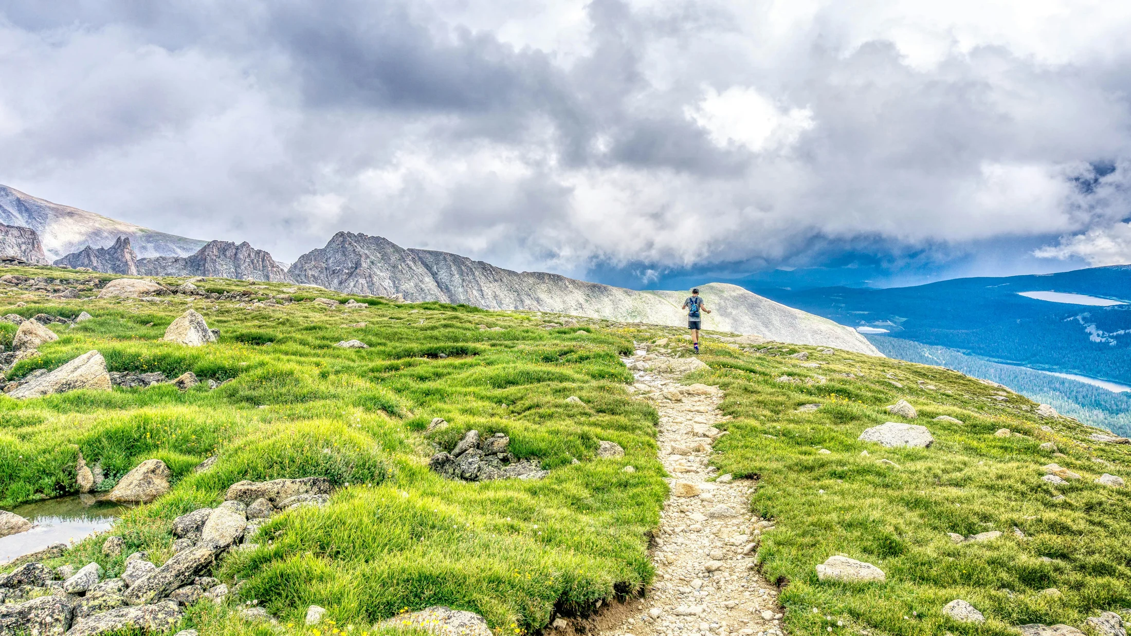
Why Trail Running in Spain Is a Great First Step
Thinking about your first steps off-road? Trail running in Spain offers a friendly springboard. The sport mixes running with natural terrain—tracks, forest paths, and mountain footways—without the pressure of technical mountaineering. Over the last decade, federations and local clubs have grown events and waymarked routes across regions like Asturias, Madrid, and the Canary Islands; the International Trail Running Association notes that “trail” simply means running primarily on natural terrain, not a specific distance or pace. Picture soft pine needles underfoot and the faint scent of rosemary after a light rain.
Choosing beginner-friendly terrain matters more than pace. Start with short distances, modest elevation gain, and clear waymarking; good transport access and mild weather windows also help. For this list, we applied practical filters you can trust: distance (8–15 km ideal), elevation gain (under 500 m to begin), technical difficulty (limited rock scrambling), access (parking or bus), waymarking (PR/SL local trails when possible), best season (avoid heat or ice), cost (free routes or low-fee community races), and atmosphere (supportive, local, well-organized).
Each pick below blends scenery with simplicity to help you build confidence. Families find gentle forest loops, couples enjoy coastal sunsets, and friends can try short “taster” races with measured climbs. Use this list to select a first outing close to home, then add distance or elevation gradually as your legs and technique adapt. Your first mountain running routes in Spain should feel welcoming, not overwhelming.
Picuco te puede ayudar
Does something here catch your eye?
Tell us.
Write to us on WhatsApp or email: we answer questions, find the best options and help you sort out the booking.
How to Use the Route and Race Profiles
Every entry follows the same, quick-to-scan format so you can compare apples to apples. We start with location and access: nearest town, road approach, and public transport hints; if you rely on GPS, look for official GPX tracks via local councils or regional parks. Then we note price or registration: most routes are free year-round, while community events charge modest fees; always confirm updated prices on the official event page.
You will also see best season, ideal for (beginner level and goals), a short “what to do” route sketch, and a safety/logistics block with parking, water, and any permits. Imagine a brief breeze on the trail as you glance between map and notes. Use these entries to plan: download the GPX, check if any protected areas require prior authorization, and verify bus timetables for start/finish access. If you are considering beginner trail races in Spain, scan cut-off times and mandatory kit, then select the shortest option or one labeled as “popular.” This structure helps you pick a day, pack smart, and run at your own pace.
Trail Running Spain: 10 Starter Races and Routes to Begin Mountain Running
Ruta Mina de la Plata (bustarviejo, Madrid): short loop with historic charm
Start in Bustarviejo, about 65 km north of Madrid via the A-1, with weekend buses from Plaza de Castilla to the village. This is a compact loop with variants around 5–8 km and roughly 150–300 m of ascent on dirt paths and old mining tracks. A cool thread of air flows from the old galleries as you crest the low ridge. You can run it free anytime; spring and autumn bring mild temperatures and clearer skies.
- Location and access: Bustarviejo village; parking near the old station or village center; bus connections on regional lines.
- Best season: March–June and September–November.
- Ideal for: first off-road outing; testing pacing on rolling paths.
- Terrain: compact dirt, some rocky steps, well-marked local paths.
- What to do: visit the historic silver mine area, add a viewpoint spur if legs allow.
Why it works for beginners: clear waymarking, forgiving gradients, and easy bailouts back to town. Safety and logistics: carry 0.5–1 L of water, watch for loose stones near the mine, and avoid after heavy rain when clay sections get slick. For your first trail running Spain experience, keep effort conversational, use grippy trail shoes, and pack a light wind layer.
Trail Cabo de Ajo (cantabria): coastal singletrack with Cantabrian views
The Faro de Ajo area sits on the Bareyo coast, 45 minutes from Santander via the A-8 and CA-141, with parking near signed coastal paths. Expect 8–12 km options with about 100–200 m of climb, mostly along clifftop tracks and farm lanes. Waves drum the base of the cliffs as gulls wheel overhead in the salt air. No fee applies unless tied to a local fun run; spring and autumn offer cooler breezes and fewer crowds.
- Location and access: Ajo/Bareyo; signed paths to the lighthouse; limited public transport—check weekend buses.
- Best season: April–June and September–October.
- Ideal for: coastal scenery with short technical bursts; building foot placement skills.
- Terrain: grass, compact dirt, scattered rock slabs; exposed to wind.
- What to do: lighthouse viewpoints, short detours to small coves.
Beginner tips: choose low tide windows for safer shore-level detours and wear shoes with good wet-grip rubber. Safety: strong winds can buffet clifftops; keep distance from edges and avoid waves on surge days. If a local starter trail race pops up here, pick the shortest course; confirm route markings and cut-offs on the event page.
Carrera por Montaña Garganta de los Infiernos (jerte, Extremadura): pools and gorge paths
Set in the Valle del Jerte, 2.5–3 h west of Madrid via the A-5 and EX-203, with parking near the nature reserve access points. The organized race typically offers multiple distances; for a first try, target shorter formats around 10–15 km with 250–400 m of ascent. Water chatters over granite into the famous Pilones as the trail ducks between oaks. Spring brings cherry blossoms; summer invites a post-run dip.
- Location and access: Jerte and Cabezuela del Valle; signed reserve entries; occasional bus services from Plasencia.
- Registration/cost: community-level fees; confirm dates and kit on official channels.
- Ideal for: first organized event; sampling “carreras de montaña cortas.”
- Terrain: granite slabs, forest dirt, well-trodden reserve paths.
- What to do: the Pilones pools, shaded ravines, short viewpoint spurs.
Why it’s beginner-friendly: clear signage inside the reserve and a vibrant, supportive atmosphere. Logistics: arrive early to park, carry 1 L of water in summer, and respect reserve rules (no shortcuts, pack out trash). For easy trail runs Spain style, keep cadence high and strides short on rock slabs; poles are optional but useful on granite steps.
Trail Tierra de Ibias (asturias): soft forest tracks and rural lanes
Ibias lies in southwest Asturias, reached from Oviedo in about 2.5 h via the A-63 and AS-15, threading into green valleys. Expect event and training options 10–14 km with 300–450 m of gain on forest pistes, pasture tracks, and brief singletrack. Mossy air cools your face beneath beech and chestnut canopies. Spring and autumn shine with stable temperatures and fewer storms.
- Location and access: San Antolín de Ibias area; rural parking; limited buses—consider carpooling.
- Registration/cost: modest community-race fees; check federation calendars.
- Ideal for: first elevation tests on soft footing; pace control on climbs.
- Terrain: grass and dirt lanes, forest pistes, short rocky steps.
- What to do: small hamlets, farm terraces, stream crossings.
Beginner edge: forgiving surfaces reduce impact, and gradients trend moderate. Pack a waterproof in unstable weather, and plan lodging in rural guesthouses to enjoy local cuisine and support the community that maintains these paths. If storm forecasts rise, shift to a lower loop and avoid ridge spurs.
Carrera de Montaña de Aoiz (navarra): popular circuit with festive energy
Aoiz/Agoitz sits 30 km east of Pamplona on the NA-150, with easy parking and town services. The event typically includes short courses in the 10–12 km range with 300–450 m of ascent, looping through oak patches and rolling hills. Cowbells and cheers bounce between stone facades as you leave the plaza. The race date guides your timing; spring often hosts the shorter options.
- Location and access: Aoiz center; straightforward drive from Pamplona; bus options on regional lines.
- Registration/cost: accessible fees; entries open weeks in advance—sellouts possible.
- Ideal for: first bib experience in Spain; “starter trail races” with town support.
- Terrain: compact dirt, field paths, brief rocky gullies.
- What to do: warm-up on the river path, post-race pintxo in the square.
Why debut here: friendly marshals, solid markings, and multiple distances. Logistics: collect bib early, respect cut-offs, and bring a light shell plus 0.5–1 L of water. Safety: watch footing on descents through leaf litter after rain. This is a textbook pick among beginner trail races Spain newcomers love.
Trail Santuario de Consolación (iniesta, Cuenca): gentle climb and La Mancha horizons
Iniesta lies 1 h east of Cuenca on the A-3 corridor, with simple access and parking around the town edges. Expect 8–14 km options, 150–300 m of gain, and broad farm tracks rising toward the Santuario de Consolación. Dry thyme brushes your calves as swallows trace low arcs at dusk. Late autumn through spring is best; summer heat demands an early start and extra water.
- Location and access: Iniesta; direct road access; limited bus service.
- Registration/cost: often free as a route; occasional local events charge modest fees.
- Ideal for: first continuous run on rolling terrain; testing hydration strategy.
- Terrain: wide dirt tracks, light gravel; low technicality.
- What to do: sanctuary viewpoint, vineyard lanes, sunset return.
Beginner wins: very low technical demand and steady grades. Logistics: carry 1–1.5 L in warm months, wear a cap, and consider gaiters for gravel. Safety: scarce shade—avoid midday. If a local popular race is scheduled, pick the shortest loop and confirm aid stations; otherwise, self-support with water and a salty snack.
Arganza Trail — Cañón del Río Lobos (san Leonardo de Yagüe, Castile and León): canyon paths with clear markings
San Leonardo de Yagüe sits along the N-234 between Soria and Burgos, serving as a gateway to the Cañón del Río Lobos Natural Park. Beginner-friendly event routes and training loops span 10–12 km with 200–350 m of ascent. The scent of juniper mixes with the echo of jackdaws skimming limestone walls. Autumn and late spring balance cool air and open trails.
- Location and access: town parking and park entrances are well signed; car recommended.
- Registration/cost: community-level fees; annual Arganza Trail options often include short loops.
- Ideal for: first taste of canyon singletrack; steady river-grade running.
- Terrain: sandy path, limestone gravel, short rooty sections.
- What to do: Ermitas, miradores, possible detours to bird lookouts.
Beginner upside: park paths are marked and gradients manageable; shorter loops allow easy time goals. Safety and ethics: respect park regulations, stay on paths to protect nesting areas, and pack out everything. For routes labeled as “rutas trail para iniciarse,” bring poles only if you already train with them; otherwise, keep hands free on narrow ledges.
Trail Vila de Cuntis (pontevedra, Galicia): green trails with moderate technical steps
Cuntis sits 30 minutes from Pontevedra via the N-640, with town parking and thermal-town services. Event short courses and training loops run 10–12 km with 250–400 m of ascent across mixed woodland and stream crossings. Ferns bead with mist as water hums over rounded stones. Choose spring or early autumn; winter can be very wet and slippery.
- Location and access: Cuntis center; simple drive; limited buses—check weekdays.
- Registration/cost: approachable fees for short courses; confirm mandatory kit in wet conditions.
- Ideal for: building confidence on roots and mud; varied footing without exposure.
- Terrain: forest soil, roots, wooden footbridges, some rocky steps.
- What to do: riverside warm-up, short climbs to village viewpoints.
Why it suits beginners: moderate distance with playful terrain that teaches footwork. Safety: select shoes with pronounced lugs and consider merino socks to reduce blister risk in wet. Logistics: bring a waterproof jacket and small first-aid strip. Among mountain running routes Spain-wide, this is a gentle classroom for technique.
Ruta Benijo — Roque Bermejo (tenerife, Canary Islands): volcanic paths and coastal breeze
On Tenerife’s north-eastern tip in Anaga, reach Benijo from Santa Cruz in about 1 h via the TF-11 and TF-12 to Taganana, then down to the coast. Plan 10–12 km out-and-back or point-to-point variants with 400–600 m of ascent on volcanic soil and stone paths. Sea spray hangs in the air as trade winds comb the ridges. Go in winter or spring for cool, clear days; summer heat and exposure can be harsh.
- Location and access: Benijo/Taganana; limited parking; buses serve Taganana—confirm schedules.
- Best season: November–May; start early for calm winds.
- Ideal for: first island outing with big scenery; manageable technical steps.
- Terrain: volcanic grit, stone steps, cliffside paths with railings in places.
- What to do: coastal viewpoints, optional spur toward the Anaga lighthouse (check restrictions).
Beginner guidance: keep strides short on stone steps and hike the steeper ramps. Safety: strong sun and wind—bring 1–1.5 L water, hat, and wind layer; avoid wet stone after squalls. Logistics: consider a bus link for a one-way run; always check park notices and avoid trail closures. This ranks among “rutas trail fáciles España” by scenery-to-effort ratio, provided you mind exposure and conditions.
La Pedriza Short Loop (sierra de Guadarrama, Madrid): granite playground with meadows
La Pedriza lies 60 km from Madrid, accessed via M-608 to Manzanares el Real and the La Pedriza entrance at Canto Cochino, with parking quotas on peak days. Choose a 7–10 km loop around the lower slabs and meadows with 250–400 m of ascent. The sun warms pale granite as magpies flick across broom bushes. Late spring and autumn bring stable grip; winter ice and summer heat complicate things.
- Location and access: Canto Cochino parking; public buses to Manzanares el Real, then a walk-in or taxi.
- Best season: April–June and September–November.
- Ideal for: first contact with granite; pacing climbs without exposure.
- Terrain: granite slabs, sandy path, short rock gardens.
- What to do: Charca Verde spur, meadow circuits, low ridge viewpoints.
Beginner approach: avoid steeper slab scrambles; pick signed lower loops and keep hands free. Safety: granite gets slick with frost or dust—test traction and slow on descents. Logistics: check access regulations and parking reservations in advance; carry 1 L water, sun protection, and a light layer. If you seek a “primer trail España” classic near Madrid, this is a proven classroom.
Where These 10 Spots Are on the Map
Use an interactive map to visualize spread and travel time between locations, cluster runs into a weekend, and check nearby altitude and gradient. A crisp line on the screen mirrors the ridge you’ll feel underfoot. Each marker should include: name, distance/elevation range, difficulty tag (beginner, beginner-plus), coordinates with reasonable precision, and a link to the matching profile section on this page.
For the web version, add layers for seasons (cool-weather, shoulder-season, year-round), filters by elevation gain, and an option to download GPX tracks per route. Consider base layers that show relief shading and protected areas to respect park rules. Always provide descriptive alt text (e.g., “short forest loop in Ibias with 300 m ascent”) and confirm coordinates against official park or municipal sources before publishing.
Practical Tips for Choosing Your First Trail Event or Route
Pick distance and ascent that match your current weekly running. As a rule of thumb, if you comfortably run 8–10 km on roads, choose a trail event of 8–12 km with under 400 m of climbing. Think of elevation gain as “stairs in disguise”: more meters mean slower splits and higher effort. One crisp breath at the crest reminds you to respect the climb.
Assess terrain. “Technical” means roots, rocks, steps, or off-camber paths that challenge balance. For your first outing, favor compact dirt and clear singletrack, leaving loose scree and big slabs for later. Check season and weather: spring and autumn are kinder across most regions; in summer, run early and carry more water; in winter, avoid ice and short daylight.
Gear basics:
- Trail shoes with reliable grip
- 0.5–1.0 L soft flasks or small vest (1–1.5 L in heat)
- Light wind/water layer
- Nutrition: 1 gel or bar per 45–60 minutes
- Phone, ID, and a small blister kit
Read the course profile: note where the main climb and descent sit, and plan to run easy to the base, hike briskly uphill, and open your stride on safe, gentle descents. Logistics matter: confirm parking or bus times, arrive early for bib pickup, and book nearby lodging if start times are early. For beginner trail races Spain-wide, register early for the shortest distance, review mandatory kit lists, and set a finish-time window, not a single target, to keep stress low.
Frequently Asked Questions
How do I sign up for a beginner trail race in Spain?
Look for community events via regional federations, municipal sports pages, or club social channels, then choose the shortest distance. Register early, confirm the mandatory kit list, and review cut-offs and refund policies on the official event page.
What gear is essential for a first trail?
Wear trail shoes with decent lugs, pack 0.5–1 L of water (more in heat), a light shell, and a simple nutrition plan. Carry your phone, ID, and a small blister kit. Poles are optional; only bring them if you already practice with them.
What is the minimum fitness level I need?
If you comfortably run 8–10 km on flat roads, you can handle an 8–12 km beginner trail with under 400 m of ascent. Walk the steeper climbs, keep effort conversational, and prioritize finishing feeling strong over speed.
How do weather and season affect my choice?
Heat, wind, and precipitation change footing and hydration needs. Prefer spring and autumn in the interior; on coasts and islands, watch for wind and slick rocks. In summer, start early, carry extra water, and seek shaded routes; in winter, avoid ice and short daylight windows.
What safety rules should I follow?
Tell someone your plan, carry water and basic first aid, respect park rules, and stay on marked trails. Slow down on technical descents and turn back if storms build or footing degrades. In protected areas, follow signage and avoid nesting zones.
Where can I find more easy trail runs in Spain?
Check municipal tourism pages, natural park visitor centers, and PR/SL-marked local trails. You can also look up regional trail associations and community clubs for GPX downloads of beginner-friendly loops.
Book your experience — discover outdoor activities in Spain with providers verified by Picuco.
Conclusion
These ten beginner-friendly trails and community races balance scenery, clear waymarking, and manageable climbs so you can start trail running in Spain with confidence. Choose one that matches your current distance and season, download the GPX, and pace yourself to finish smiling. Share your outing with friends or family, and consider a short bibbed event once you feel steady on dirt. Your mountain running journey grows one careful step at a time—respect weather, carry the basics, and thank the local communities whose paths you enjoy.