Why Seek Crystal-clear Rivers?
You come to the water for calm, for color, and for the thrill of seeing the riverbed. In Spain, the clearest rivers reward you with relaxation, easy photography, rich biodiversity, and simple outdoor plans that fit families, couples, and small groups. When we say the clearest rivers Spain can offer, we mean stretches where light reaches the bottom and you can read the stones as if through glass.
Natural pools differ from crystal-clear rivers: a natural pool is a still or slowed section where you can swim comfortably, while a crystal-clear river is the moving course itself, often fed by springs or high-mountain meltwater. One can hold the other—many natural pools in Spain form inside crystal-clear rivers—but the goal here is flow plus transparency. Think of it as clarity you can move through. Sunlight on water flashes like mirrored scales.
In this guide you will find 12 carefully selected stretches that stand out for clarity, scenic value, and access. For each stretch we explain location, why the water is so clear, how to get there, what to do (from swimming in rivers in Spain to riverside walks), and how to respect local rules. We also include planning advice: when to go, safety basics, accommodation ideas, and seasonal tips to combine nearby spots in one escape.
What you will not find are promises of easy bath spots where they do not exist—some protected places prohibit swimming to protect fragile habitats. That honesty helps you plan better days. For practical trip building, save the shortlist, check local park pages for updated rules, and consider pairing nearby valleys across a weekend. You will travel slower, see more, and leave less trace.
Picuco te puede ayudar
Does something here catch your eye?
Tell us.
Write to us on WhatsApp or email: we answer questions, find the best options and help you sort out the booking.
Escríbenos
What Makes Water So Clear?
Clarity in rivers is not luck; it is geology, ecology, and care working together. The clearest rivers in Spain usually start as springs (karst aquifers dissolving limestone) or high-mountain meltwater with low sediment load. In both cases, the water carries fewer fine particles, so light passes through and you see the bottom at a glance. On quiet mornings, the surface reflects birch leaves like a polished lens.
Several physical features drive transparency:
- Source: Spring-fed rivers emerge filtered through rock, often limestone, which traps sediments and stabilizes temperature.
- Substrate: Rocky or gravel beds resist stirring up fines compared to muddy or clay-rich beds.
- Flow regime: Moderate flow clears suspended particles; too fast and turbulence clouds water, too slow and algae may bloom.
- Riparian vegetation: Trees shade the channel, regulating temperature and limiting algal growth; roots also stabilize banks, reducing erosion.
- Temperature and light: Cold water holds more oxygen, supports balanced communities, and slows algal overgrowth; dappled light discourages nuisance blooms.
- Natural settling zones: Pools below small steps act like informal decanters, dropping out silt after spates.
Ecosystems also polish water. Invertebrates like caddisfly larvae and freshwater shrimps graze biofilms; macrophytes (aquatic plants) trap particles; fish schools stir but also signal healthy oxygen levels. A clear river is a living filter, with each organism playing a role in the water’s transparency. When you see darting minnows above pale cobbles, you are reading the river’s health.
Human impact can make or break clarity. Pollution (nutrients, detergents, untreated sewage) drives algal blooms, while dams alter natural flow and temperature. That said, well-managed reservoirs can buffer floods and reduce turbidity downstream during summer—clarity may rise but habitat can simplify, so the full picture matters. Gravel extraction, livestock access, and off-road tracks near banks also add sediments; local best practices and fencing help a lot.
If you are on the riverbank and want to judge clarity quickly, use these field cues:
- Color: Blues and pale greens suggest depth with low suspended sediment; brown/grey hints at silt.
- Visibility: Can you see the riverbed at knee or waist depth? Aim for 60–100 cm visibility in pools.
- Substrate detail: Individual pebbles visible from 2–3 meters away signal low turbidity.
- Sound: A crisp, tinkling riffle often accompanies clean stony beds; dull roars can mean higher flow and turbidity.
- Smell: Clean, faintly mineral scents are good; sulfurous or sewage odors warn of issues.
- After rain: Many clear rivers cloud for 12–48 hours after heavy rainfall—schedule your swim 1–2 dry days later.
Together, geology, shade, moderated flow, and low nutrients create the textbook “crystal clear rivers Spain” visitors dream of, but the last piece is ours: follow rules, avoid soaps, and tread softly.
Where To Find Spain’s Clearest Stretches
Use this section as your field map. Stretches group naturally by region, so you can combine two or three over a weekend. Distances between the Picos de Europa valleys are short (30–90 minutes by car), while leaps between central and eastern Spain require 3–5 hours—plan one anchor base and day-trip to surrounding rivers. Quiet weekdays, early starts, and shoulder seasons amplify your chances of empty pools.
For each place we cover location, why the water is so clear, access and transport, activities (from easy photos to the best rivers to swim in Spain), and conservation notes. If you travel with children, look for “family-friendly access”; for hikers, we highlight classic river gorges Spain is famous for. Shade your route with a paper map, and let the valley tell you when to stop for a swim.
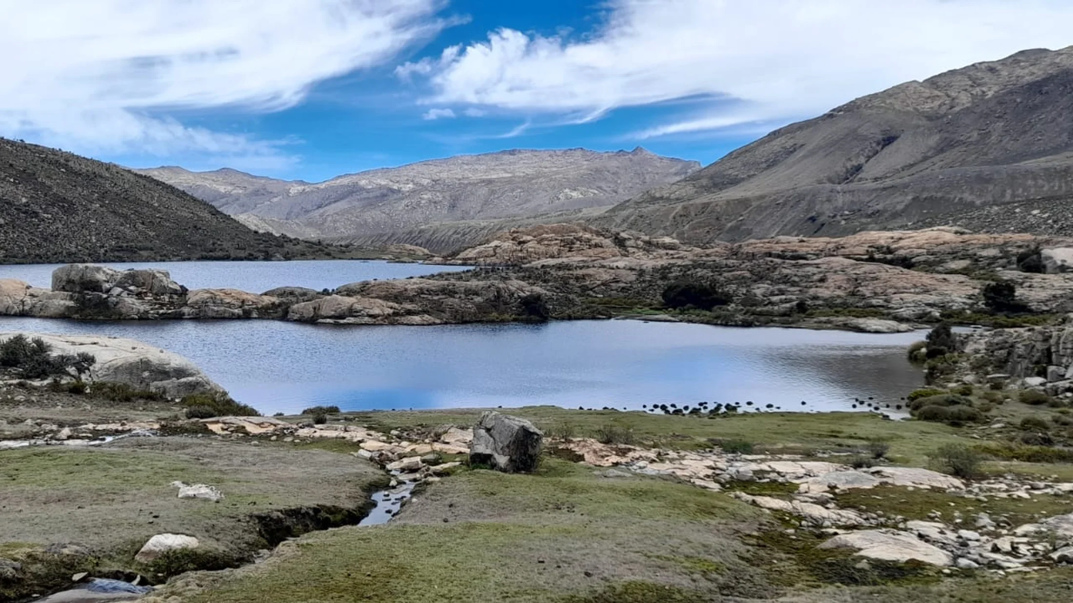
Río Cares: gorge trail and high-mountain clarity
The Cares slices through the Picos de Europa between Asturias and León, with the classic path linking Poncebos and Caín (~12 km one way, 24 km return; 4–7 hours). Access the Asturian side from Arenas de Cabrales to Poncebos; limited parking means arriving before 9:00 in summer is wise. Springs, snowmelt, and a hard limestone bed keep the Cares remarkably clear in low and mid-summer. Sunlight stutters across the emerald channel beneath cliffs 1,000 m high.
The best natural pools appear near calmer eddies below small cascades closer to Caín, but currents can be strong and temperatures hover in single digits even in July. The path is narrow with drop-offs; not recommended for very young children. Photo stops abound by carved tunnels and bridges; expect shade in the morning and bright walls by midday. You can also walk partial segments out-and-back for 2–3 hours to focus on pools and views.
Conservation note: This is within a national park; pack out all waste and skip swimming if flows are high. Buses run seasonally in the valley; check local timetables to avoid parking stress. For “swimming in rivers Spain” without the exposure of the cliff path, choose calmer tributaries in nearby valleys.
Río Urederra: source and turquoise pools in Navarra
In Navarre’s Urbasa-Andía Natural Park, the Urederra rises from a spectacular spring below a limestone wall, flowing into blue-green pools shaped by travertine (precipitated calcium carbonate). Access starts from the car park near Baquedano, with a signed loop track (2–3 hours) to viewpoints above the pools. The water’s turquoise tone comes from dissolved limestone and suspended calcite that scatter light. Fallen beech leaves drift like copper coins across the pale bed.
This area is strictly protected: a visitor quota applies year-round, and bathing is prohibited to preserve fragile formations and aquatic life. Book your visit slot in advance, especially on weekends and holidays. The path is family-friendly but keep children to the trail; stepping on travertine damages it. The best vantage points are signed miradores where you can photograph the river without trampling banks.
Conservation note: Stay within marked areas and respect the no-swim rule; it is what keeps these natural pools in Spain pristine. Nearby villages offer services and picnic spots; choose those for your breaks rather than riverside meadows.
Hoces del Río Sil: canyons and glassy reaches in Ribeira Sacra
In Ourense’s Ribeira Sacra, the Sil runs through deep granite canyons where wind-sheltered meanders can show striking clarity on calm days. Access scenic balconies by car—Santo Estevo, Cabezoás, or Vilouxe are classic viewpoints—or explore by kayak and seasonal boat trips from local embarcaderos. Steep vineyards form green ladders above slate and stone. In the early evening, the canyon holds a quiet echo and the river lies like smoked glass.
Why so clear at times? In the lower-flow months (late spring to early autumn) and sheltered bends, suspended sediments settle, and the dark bed enhances the impression of depth. Bathing is possible only with extreme care and local advice; currents, boat traffic, and steep banks make entry and exit tricky. Families should enjoy views and short paddles with certified operators rather than free swimming.
Conservation note: The Sil canyon hosts raptors and otters; keep noise low and wake-free. If you paddle, avoid scraping hulls on shallow shelves and give anglers space at calm inlets.
Hoces del Cabriel: clear waters on the Cuenca–valencia border
The Hoces del Cabriel Natural Park protects Spain’s longest free-flowing stretch on the Cabriel, a river known for clarity, riffles, and banks of white cobbles. Access from towns like Villargordo del Cabriel, Venta del Moro, or Casas del Río; signed trails lead to river beaches and shaded picnic areas. Limestone, low nutrient input, and partial protection keep the water clean and bright. In summer, swallows flicker low over blue-green runs.
Where to swim? Look for established river beaches and calm bends; some sectors like Las Chorreras (near Enguídanos, Cuenca) operate seasonal capacity control and may require advance reservation. Typical activities include gentle rafting, canyoning in tributary gorges, and relaxed bathing in eddies. Arrive early on hot weekends and bring sturdy river shoes—gravel shifts underfoot.
Conservation note: Follow marked tracks and parking rules, and check whether permits apply in peak season. The river corridor is recovering from past pressures; help by staying off fragile banks and packing out all litter.
Garganta de los Infiernos (río Jerte): protected pools and cascades
In Cáceres’ Jerte Valley, the Garganta de los Infiernos Reserve protects a sculpted granite gorge famous for its “Pilones” potholes—linked natural pools shaped by swirling water. Start from the visitor area near the town of Jerte and follow a well-signed trail (2–3 hours round trip to the main pools). Granitic bedrock, fast winter flushing, and low summer nutrients keep waters clear in the bathing season. Dragonflies stitch blue threads above the pale bowls.
Bathing is allowed in designated areas, but heed posted warnings about slippery rock and sudden changes after storms. The approach is family-friendly with some uneven steps near the pools; river shoes and a light drybag help. Midweek mornings in June and September balance warm air with reasonable flows and fewer crowds.
Conservation note: No fires or soaps; use toilet facilities at trailheads. The gorge is a protected area—stay within marked bathing zones to protect riparian plants that stabilize banks.
Nacimiento del Río Mundo: waterfall, plunge pool, and crystal springs
In Albacete’s Calares del Mundo y de la Sima Natural Park, the Mundo River bursts from a cave in a multi-tiered waterfall known for the dramatic “reventón” events after heavy rain. The spring water runs cold and clear over limestone shelves, building pale terraces downstream. Spray hangs in the air like cool glass beads on bright days.
Access via the parking area near Riópar; short signed paths lead to viewpoints at the base and mid-level terraces. The immediate source zone is strictly protected—no bathing at the main waterfall—but there are calmer stretches further downstream outside the core area where paddling may be tolerated; check on-site signage. Early morning visits avoid queues, and services in Riópar cover food and lodging.
Conservation note: Stay behind barriers near the fall, which protect rare ferns and stabilize slippery bedrock. The clarity you see starts inside the mountain; leave it as you found it.
Río Borosa: footbridges, emerald pools, and classic Cazorla hike
The Río Borosa is a signature route in the Sierras de Cazorla, Segura y Las Villas Natural Park (Jaén). Starting near the Torre del Vinagre visitor center, a graded track follows the river before narrowing through the Cerrada de Elías via footbridges and tunnels, with clear pools and cascades all along. Boxwood shadows drift over pebble fans like moving lace.
Expect 9–10 km to the Cerrada de Elías and back, or 22–24 km if you continue to the Aguas Negras and Valdeazores dams (6–8 hours). Families can do the lower section to the gorge and return for picnic swims in calm eddies; water remains cold even in July. Bring a headlamp for short tunnels and mind wet rock near cascades.
Conservation note: Wild camping is prohibited; use designated campgrounds outside the core. Swimming is generally tolerated in low sections—avoid trampling aquatic plants and exit where paths already reach the water to minimize bank erosion.
Montanejos (río Mijares): thermal feel and clear, steady flows
Montanejos, in Castellón’s Alto Mijares, is famous for the Fuente de los Baños, a spring-fed section of the Río Mijares that stays around 22–25°C much of the year. Limestone channels and a stable thermal input keep the water strikingly clear. Warm vapor lifts slightly off the surface on cool mornings like breath over a mirror.
Access is straightforward from the village, with signed paths to the main bathing area; services include lifeguards in high season, toilets, and shaded picnic zones. Capacity control and paid access may apply in summer—arrive early and check current rules in town. Families find gentle entries and shallow shelves; river shoes help with rounded cobbles.
Conservation note: Stick to marked entry points to avoid bank wear. In peak season, choose midweek or late afternoon for calmer water and better photos of these natural pools in Spain.
Río Deva: mountain-fed runs in Liébana and Picos de Europa
The Deva drains the central Picos and Liébana valleys, carrying cold, lucid water over limestone and slate. Between Potes and La Hermida you will find calm remansos off the main flow, with gravel beaches for careful dips in summer. Clouds snag on ridgelines while the channel gleams like bottle glass below.
Access is mainly roadside plus short footpaths from parking pull-outs; always enter where the bank is gentle and exit is certain. Afternoon thunderstorms can spike flow in minutes in July–August, so swim early and keep sessions short. Pair a Deva stop with short valley walks or cable-car trips to higher viewpoints.
Conservation note: This is trout water with active angling—give space to lines and avoid disturbance. Low-impact bathing means no soaps, keep sunscreen minimal and applied well before entering, and pack out everything you bring.
Gredos Gorges (tagus headwaters): cold mountain pools in Ávila
On the northern flanks of the Sierra de Gredos (Ávila), tributaries of the Tagus carve clear gorges and deep pools. One beloved spot is the Pozo de las Paredes near Navalperal de Tormes, where stone arches span a green plunge pool on the Barbellido. The water shows a dark jade under granite ledges, with trout shadows slipping like ink.
Access is via narrow local roads and a short walk from small car parks; expect frigid temperatures year-round and slippery rock shelves. Families can paddle near the shallows on warm days, but strong swimmers only for full immersions. Other nearby gargantas offer similar clarity with varied access—ask in villages for current parking arrangements.
Conservation note: Spring melt can make currents deceptively strong; avoid early spring dips. Use existing paths down to pools to protect cushion mosses and saxifrages on rock faces.
Río Majaceite: Benamahoma’s pools in Grazalema
In Cádiz’s Sierra de Grazalema, the Majaceite flows from Benamahoma to El Bosque along one of Andalusia’s friendliest riverside trails. Alder and ash line a cobble-bottomed channel that runs clear in late spring and summer, with shaded pools ideal for short family dips. Kingfishers spark electric blue along bends like thrown pebbles of sky.
The path is mostly level (2.5–3 hours return), with several informal access points to the water. Choose calm backwaters, watch for slippery roots, and keep swims brief—flow can change after storms. Weekdays and early mornings are best for quiet.
Conservation note: The river supports native trout and sensitive riparian plants; enter only at obvious, already-worn banks and never move rocks to build dams. Local towns offer cafés and refill points—keep food away from the waterline.
Río Sella: clear Asturian runs and swim-friendly eddies
The Sella’s fame comes from canoeing between Arriondas and Ribadesella, but in low summer flow it also offers clear eddies for refreshing dips. Look for calm pockets near river beaches and secondary channels where boat traffic is light. Pebble bars rise like pale lozenges under mint-green water.
Access is easy from towns along the N-634; park legally and walk to signed river beaches. Swim early or late to avoid canoe crowds, use bright tow-floats for visibility, and never cross the main channel when boats are passing. Combine a short swim with a half-day descent in a canoe for an ideal mixed plan.
Conservation note: Follow local regulations about bathing areas and respect anglers’ zones. Keep noise low near villages and leave banks as you found them.
When To Go: Seasons and Conditions
Clear water depends on timing as much as place. In mountain rivers, early summer through mid-September often brings the best clarity once snowmelt has passed and sediments have settled. In karst spring systems, clarity is stable across summer and autumn, with quick recoveries after rain. In thermal rivers like Montanejos, winter and shoulder seasons add calm and warm water—but watch for short daylight. A dawn chill on the bank sharpens the scent of wet stone.
Consider three river types:
- High-mountain and snowmelt-fed: Peak clarity from late June to September; cold temperatures year-round; flashier after storms.
- Spring-fed/karst: Stable clarity, cool to cold, best from May to October outside heavy-rain episodes.
- Thermal-influenced: Usable year-round; clearest on calm, dry days; capacity controls in summer.
Key weather drivers:
- Rainfall: After heavy rain, expect 12–48 hours of turbidity; plan swims for the second clear day.
- Snowmelt: Late spring flows are high and cold; clarity rises as hydrograph flattens in early summer.
- Heat waves: Warm air, but watch for algal growth in slow backwaters; choose shaded runs.
- Wind: Sheltered bends stay glassy; strong winds ripple surfaces and reduce visual depth.
A simple seasonal comparison helps you plan.
| Season | Pros | Cons | Best for |
|---|---|---|---|
| Spring | Full flows, wildflowers, cool air | Snowmelt cold, turbidity after rain | Hiking riversides, short dips |
| Summer | Warm air, lower flows, best clarity | Crowds, capacity rules, afternoon storms in mountains | Family swims, photography |
| Autumn | Stable water, fewer people, warm colors | Shorter days, first rains can cloud water | Quiet escapes, kayak |
| Winter | Thermal spots quiet, crisp light | Very cold water, limited daylight, icy banks | Montanejos, viewpoints |
Recommendations by region/type:
- Picos de Europa (Cares, Deva): Late June–September for clarity; avoid immediately after storms; mornings are best for photos in gorges.
- Navarre (Urederra): Year-round visits with booking; autumn blues against beech foliage are superb; no swimming any time.
- Ribeira Sacra (Sil): Late spring to early autumn for calm surfaces; aim for early or late day paddles.
- Eastern limestone rivers (Cabriel, Montanejos): May–October with best swimming in June and September; midweek to dodge crowds.
- Central mountains (Borosa, Gredos, Mundo): June–September for swims; spring for full waterfall shows but colder, riskier bathing.
Time of day matters. Early morning gives empty banks and calm air; mid-afternoon warms stone for lazing but can bring wind and people; golden hour saturates greens and blues for photos. After any rainfall alert, wait at least a day for mountain rivers to clear and check park advisories (AEMET weather bulletins and local park pages publish warnings). Always match group plans to the weakest swimmer and the day’s conditions.
Where To Stay: Rural Homes, Campgrounds, and Hostels
Choosing a base near clear rivers balances proximity, capacity, and services. You want short morning drives to beat crowds and somewhere to dry towels and stash wet gear. In summer, shade and cross-ventilation are more valuable than TVs. The night air smells of pine and cold stone drying by the door.
Common options and how to choose:
- Rural houses (casas rurales): Great for families/groups; look for garden access, river within 10–20 minutes, and storage for snorkels, PFDs, or fishing rods.
- Campgrounds: Best for budget and direct contact with nature; check for quiet hours and riverside access policies; bring proper ground sheets and mosquito control.
- Hostels/albergues: Simple and central; good for hikers and small budgets; verify drying rooms or racks for wet gear.
- Small hotels/pensions: Comfort plus breakfast; ask about early check-outs for dawn swims and packed lunches.
Strategic localities:
- Picos/Deva–Cares: Base around Potes, Arenas de Cabrales, or Cangas de Onís for multiple valleys.
- Ribeira Sacra (Sil): Choose Parada de Sil or Nogueira de Ramuín for miradores and boat ramps.
- Cabriel/Montanejos: Villargordo del Cabriel, Enguídanos, or Montanejos itself for split days between rafting and swims.
- Central mountains: Riópar (Mundo), Arroyo Frío (Borosa access), Navalperal de Tormes or Navarredonda (Gredos).
- Grazalema/Majaceite: Benamahoma or El Bosque for trailheads and services.
Booking tips:
- Reserve 4–6 weeks ahead for July–August weekends near famous pools.
- If flexible, choose Sunday–Thursday stays for quieter banks.
- Ask hosts about current access rules and parking—locals know when capacity controls or shuttle systems are in effect.
- Combine two bases for a week: e.g., 3 nights Picos, 3 nights Cabriel/Montanejos; you will sample spring-fed and mountain-fed clarity in one trip.
Sustainability cues:
- Look for water-saving measures, recycling, and information on local trails.
- Walk or cycle to nearby rivers when possible to reduce parking pressure.
- Support village cafés and groceries—your breakfast euros help maintain footpaths and community life.
What To Do: Swims, Snorkel, Hiking, Kayak, and Fishing
Clear water begs you to move, watch, and listen. Mix short dips with a riverside walk or paddle and you will fill a day without rushing. Light wind shivers alder leaves while pebbles glow in knee-deep water.
Swimming safely
- Gear: River shoes, light neoprene top in mountain rivers, small drybag, bright swim cap or tow-float for visibility.
- Skills: Enter and exit only at gentle banks; never dive in unknown pools; test depth and current first.
- Regulation: Some protected areas restrict bathing; obey posted signs (e.g., no swimming at Urederra source; designated zones at Jerte, Montanejos capacity control).
- Impact: No soaps or shampoos, apply reef-safe sunscreen at least 20–30 minutes before swimming, avoid stirring up fine sediment in spawning grounds.
Snorkel and underwater watching
- Gear: Mask and snorkel are enough in calm eddies; a thin wetsuit (2–3 mm) extends sessions in cold rivers; use a short tether to secure the snorkel if currents tug.
- Skills: Float prone, keep fins small or go barefoot with river shoes to avoid stirring sediment; practice controlled breathing.
- Regulation: Stay out of angling zones; in protected stretches, snorkeling may be treated as bathing—follow the same rules.
- Impact: Do not chase fish or overturn cobbles; macroinvertebrates and fish use spaces under stones as shelter.
Riverside hiking
- Gear: Lightweight shoes with grip, small first-aid kit, water filter or bottles.
- Skills: Choose official trails; watch for polished roots near river margins; keep children close on narrow paths.
- Regulation: Dogs often must be leashed; check seasonal closures after storms or fire alerts.
- Impact: Stay on trail to prevent bank erosion; use existing photo pull-outs.
Kayak and gentle paddling
- Gear: PFD (personal flotation device) for everyone, helmet in moving water, closed footwear; drybag for layers.
- Skills: Choose class I–II sections for families; hire certified operators for canyon or faster water.
- Regulation: Some rivers require permits or have seasonal flow windows; respect no-go zones near dams and protected habitats.
- Impact: Launch and land at designated spots; keep wake low in wildlife-rich backwaters.
Recreational fishing
- Gear: Local-legal rod setups; barbless hooks reduce harm; polarized sunglasses to see the bottom better.
- Skills: Read water—glides, pools, and riffles; learn catch-and-release handling.
- Regulation: Regional fishing licenses and, often, day permits are mandatory; closed seasons protect spawning.
- Impact: Fish in cooler hours to reduce stress; keep fish wet and handle briefly.
Trip ideas
- Family day in Jerte: Early walk to Pilones, short swims, picnic under shade, ice cream in the village.
- Mixed mountain day in Cazorla: Morning Borosa hike to Cerrada de Elías, lunch, calm eddy snorkel, sunset photo stop.
- Eastern clarity sampler: Morning at Montanejos for a warm swim, siesta, late-afternoon paddle or riverside walk along the Cabriel.
If you want structured options with verified guides for kayaking, canyoning, or easy family paddles, check curated activities by region on Picuco and compare dates, difficulty, and what’s included.
Safety, Permits, and Respect: What Really Matters
Clear water does not mean safe water; it means you can make better choices. Scan the river like a weather report: flow, entry/exit, temperature, and other users. In the hush of a calm pool, you can hear a distant riffle like a warning bell.
Safety basics
- Flow and level: Avoid high or rapidly rising water; after rain, postpone swims 24–48 hours.
- Temperature: Mountain rivers are cold (often 8–14°C in summer); limit immersion, wear neoprene if needed.
- Currents: Eddy lines and unseen undertows develop near steps and boulders; enter in slow margins.
- Slips and falls: Granite and limestone polish underfoot; use grippy footwear and move slowly.
- Group management: Keep children within arm’s reach; set turn-around times on hikes.
Permits and local rules
- Protected areas may limit access (Urederra quotas), require paid entry (Montanejos in summer), or forbid bathing in core zones (Río Mundo source).
- Fishing always requires regional licenses and, often, day permits for specific stretches.
- Parking restrictions and shuttle systems may operate in peak months; follow signage.
- Dogs: Leash rules are common; some bathing areas prohibit pets—check municipal notices.
Conservation and low-impact habits
- Leave no trace: Pack all waste; no glass by the water.
- Sunscreen and insect repellent: Apply far from the water and well before entering to reduce wash-off; choose mineral formulas when possible.
- Soaps: Never use soaps or detergents in rivers—even “biodegradable” ones harm aquatic life.
- Bank protection: Enter and exit only where banks are already worn or reinforced; do not cut new paths.
- Rock moving: Do not build dams or “stone stacks”; they alter microhabitats for fish, insects, and plants.
Community respect
- Parking: Use official lots and pay small fees that fund maintenance.
- Noise: Keep voices low near villages and wildlife-rich canyons.
- Livestock: Close gates, give wide berth to herds, and avoid dogs approaching animals.
- Local economy: Buy locally; your breakfast and lunch stops help keep trail info current and access managed.
Checklists
- Swim kit: River shoes, microfiber towel, neoprene top (mountains), tow-float/bright cap, drybag, spare warm layer.
- Hygiene kit: Hand sanitizer, tissues, waste bag, mineral sunscreen.
- First aid: Plasters, blister kit, elastic bandage, antihistamine, water disinfectant or filter.
- Navigation: Paper map/GPX on phone, battery pack, headlamp (for tunnels like Borosa’s).
Where to verify conditions
- Official park websites and visitor centers for access rules and closures.
- Municipal pages for parking, capacity control, and pet regulations.
- River basin agencies for flow data (e.g., Duero, Ebro, Tajo confederations publish levels).
- AEMET for weather alerts in mountain areas.
A plan written on a napkin is fine if you revise it by the river: read the water, adjust, and err on the side of caution.
Frequently Asked Questions
Is it safe to swim in these rivers?
Yes, if you match your plan to conditions and skills. Choose calm eddies with easy exits, avoid swims after rain or snowmelt spikes, and keep sessions short in cold water. Children should stay within arm’s reach, and no one should dive into unknown pools.
Are the famous turquoise pools open for bathing?
Some are, some are not. At Urederra (Navarre), bathing is prohibited to protect travertine formations and water quality. In Jerte’s Garganta de los Infiernos, bathing is allowed in designated zones. Montanejos permits bathing with capacity controls in summer. Always read on-site signs.
Can I take my dog?
Dogs are often allowed on leashes on main trails but may be restricted at bathing areas or during sensitive wildlife periods. Hot rocks can burn paws, and cold water can shock dogs—use shade and bring extra water. Check municipal and park notices before visiting.
How can I tell if the water is truly clear?
Look for visibility to the riverbed at knee or waist depth, distinct pebbles from a few meters away, and minimal fine sediment when you step. Clean, mineral scent and a crisp riffle sound also indicate healthy, clear water.
What permits might I need?
You may need entry reservations (Urederra), paid access (Montanejos in summer), or fishing licenses and daily permits. For kayaking or canyoning, some stretches require authorizations managed locally by parks or river agencies. When in doubt, call the visitor center ahead.
What gear should I pack for a family day?
Bring river shoes, lightweight towels, spare warm layers, a small first-aid kit, snacks, and plenty of water. A bright swim cap or tow-float improves visibility, and mineral sunscreen applied well before swimming reduces wash-off.
Book your experience — discover outdoor activities across Spain with Picuco-verified providers.
Conclusion
Clarity is the river’s quiet miracle: geology, shade, clean flow, and care aligning so you can see the bottom and breathe easier. These 12 stretches—mountain gorges, spring-fed runs, and a thermal gem—represent the crystal clear rivers Spain is proud of, from Picos to the Mediterranean foothills. Travel early, choose shoulder seasons, and follow local rules, and you will find empty eddies and bright stones.
Plan your escape by pairing nearby valleys, staying in small rural bases, and mixing swims with walks or gentle paddles. For structured days, explore verified activities by region on Picuco and match outings to your group. Pack light, tread softly, and leave each river a little better than you found it; the water will thank you with a deeper shade of blue next time.