Why Spanish National Parks Belong on Your Travel Map
Start planning with confidence and curiosity. Spanish national parks protect volcanoes, Atlantic forests, alpine peaks, and vast wetlands across 16 protected areas. You will find a practical, traveler-first overview of what to see and do in each park, plus how to visit responsibly. A faint scent of pine, sea salt, and dry lava dust seems to travel with you from park to park.
We focus on what matters for your trip: accessibility, standout natural values, seasonal highlights, activities for different travelers, and the basic rules that keep these places wild. Each profile explains what to see, how to get there, the best time to visit, and on-the-ground tips; it helps you decide quickly and plan deeply. For facts, we rely on the National Parks Network (Ministerio para la Transición Ecológica) and each park’s official information, which detail access, closures, and safety notices.
Use this list to compare the best national parks in Spain by landscape and season: islands vs. mountains, wetlands vs. high plateaus. If you want a Spain national parks map, you will also find how to read it and filter by theme. You will come away ready to visit national parks Spain-style: at your own pace, well-prepared, and with respect for the communities who live beside these protected lands.
Picuco te puede ayudar
Does something here catch your eye?
Tell us.
Write to us on WhatsApp or email: we answer questions, find the best options and help you sort out the booking.
Spain’s National Parks on the Map
See the full Spain national parks map to orient distances, entrances, and logistics before you go. The map highlights park boundaries, main access roads and public transport nodes, visitor centers, and recommended trailheads. Lines and icons make planning simple: one layer shows islands, another mountains, and a third wetlands; switch them on to compare options fast. Picture blue coastline icons, green pine symbols, and soft marsh tones guiding your eye across the peninsula and islands.
Filter by themes such as islands, mountain, or wetland to narrow choices, then zoom for parking areas, shuttle lines, and seasonal notes. Cross-check any closure or permit symbol with the park’s official notices on the day of your visit.
What Each Park Profile Tells You
Each profile packs what you need without fluff. You get location and entry points (with a quick map cue), ticket or permit notes if applicable, best time to go, who will enjoy it most (families, birders, hikers), key activities and must-see places, and practical tips on safety and conservation rules. One clean image line evokes the feel of the place; one bullet list keeps logistics scannable. Imagine running your finger along a trail line while a breeze lifts the scent of thyme or ocean spray.
Where permits or quotas apply, we flag them and point you to official channels at visitor centers or park websites; look for "Permits and access" inside each profile’s tips list.
The Parks (1–8): Quick Profiles
1.Picos de Europa National Park: quick profile
Steep limestone massifs dive into green valleys at Spain’s first national park. Straddling Asturias, Cantabria, and Castilla y León, Picos de Europa is reachable from Cangas de Onís (Covadonga Lakes), Poncebos (Cares Gorge), Fuente Dé (cable car), and Posada de Valdeón. Mist threads through beech groves as choughs wheel over pale cliffs.
What to see and do:
- Unmissable routes: Cares Gorge (one-way ~12 km between Poncebos and Caín), Fuente Dé cable car to the high plateau, and the Covadonga Lakes circuit.
- Scenic stops: Mirador del Tombo, Bulnes village (on foot or funicular), and the lakes’ viewpoints near Enol and Ercina.
- Ideal for: hikers, mountain photographers, geology lovers, and families choosing short valley walks.
Practical planning:
- Access: Seasonal shuttle buses often regulate private cars to Covadonga Lakes—check official schedules before you go.
- When to go: Late spring–early autumn for hiking; October for beech colors; winter requires mountaineering skills.
- Safety: Weather changes fast; carry layers, water, headlamp, and a map. Stay on trails to protect limestone flora.
- Norms: No drones without authorization; dogs on leash; take all waste out.
Tip: This park sets the tone for what to see in Spain national parks—big scenery, real elevation, and serious trail time.
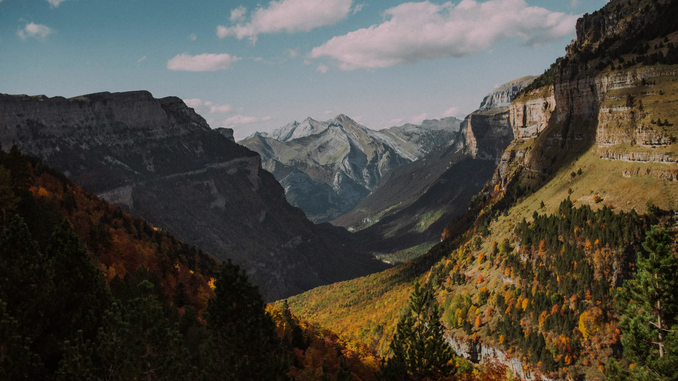
2.Ordesa y Monte Perdido National Park: quick profile
Glacial valleys and the 3,355 m Monte Perdido dominate this slice of the Aragonese Pyrenees. Main access runs through Torla-Ordesa to the Ordesa Valley, with other entries to Añisclo, Escuaín, and Pineta. Waterfalls thunder in spring as the valley breathes cool, mossy air.
What to see and do:
- Essential itineraries: Ordesa Valley to Cola de Caballo (full-day), viewpoints near Circo de Soaso, and the high, exposed Faja de las Flores (experienced hikers only).
- Family-friendly: Short walks to Gradas de Soaso or Estrecho waterfalls; interpretive trails near visitor centers.
- Ideal for: demanding day-hikers, landscape photographers, and families sticking to valley floors.
Practical planning:
- Access: In peak season, a shuttle bus from Torla regulates traffic into the Ordesa Valley—reserve or arrive early for tickets.
- When to go: Late May–June for peak waterfalls; September–October for stable weather and color.
- Trail status: Snow and ice can linger; check official daily bulletins for closures.
- Norms: Keep to marked paths; avoid wildlife disturbance; no drones without permits.
Tip: Book parking or shuttle seats in advance during holidays to visit parks like Ordesa without stress.
3.Aigüestortes i Estany de Sant Maurici National Park: quick profile
Lakes, granite spires, and black pines define Catalonia’s only national park in the central Pyrenees. Entrances cluster around Boí (Aigüestortes sector) and Espot (Sant Maurici sector), with authorized 4x4 taxis replacing private cars deep inside. You will hear water everywhere—the park’s name means “twisting waters.”
What to see and do:
- Musts: Estany de Sant Maurici with the Encantats peaks, Aigüestortes boardwalks, and lake circuits from Espot and Boí.
- Treks: Day sections of the
GR-11or a fragment of the famed Carros de Foc (multi-day, hut reservations essential). - Winter: Snowshoe routes and nearby ski-touring areas when conditions allow.
Practical planning:
- Access: Park-and-ride with local 4x4 taxis; confirm operating times in shoulder seasons.
- When to go: July–September for lake hiking; late September–October for golden larches and calmer trails.
- Logistics: Base in Boí/Taüll or Espot; public buses connect La Pobla de Segur/Sort with Espot in season.
- Norms: No swimming in most lakes; protect alpine flora; huts and quotas require advance booking.
Tip: Book huts early if you plan to link lakes—capacity is limited and demand spikes on summer weekends.
4.Teide National Park: quick profile
Spain’s rooftop volcano rises to 3,715 m at the heart of Tenerife. Approaches follow TF-21 (La Orotava–Vilaflor) and TF-24 (La Esperanza), linking easily with coastal towns and beaches for a varied island trip. Thin air, black pumice, and blinding light define this otherworldly plateau.
What to see and do:
- Highlights: Roques de García circuit, Montaña Blanca trail, and panoramic stops along the caldera rim.
- Cable car: The Teleférico ascends to La Rambleta (3,555 m); a free permit is required to continue on foot to the summit via Telesforo Bravo trail.
- Night sky: Certified dark-sky reserve; astronomy outings and self-guided stargazing are exceptional.
Practical planning:
- Access: Roads may close for snow/ice or wind; check advisories. Summit permits open online with limited daily slots.
- When to go: Late autumn–spring for clearer skies and milder temperatures; summer is hotter and busier.
- Safety: Altitude can affect you; ascend gradually, hydrate, and protect against UV and wind.
- Norms: Stay on marked paths to avoid fragile lava soils; no rock or plant collecting.
Tip: Pair dawn in Las Cañadas with an afternoon swim on the coast for a perfect islands-and-volcanoes day.
5.Timanfaya National Park: quick profile
Young lava fields and cinder cones shape Lanzarote’s living geology. The main gateway is Montañas del Fuego (Islote de Hilario) near Yaiza and Mancha Blanca; access inside the core zone is strictly controlled. The land crackles underfoot, heat shimmering above rippled basalt.
What to see and do:
- Core visit: Park-operated bus route along the Volcanoes Route from Islote de Hilario, plus geothermal demos.
- Guided walks: Limited-capacity trails (e.g., Tremesana, Litoral) require advance reservation with the park.
- Nearby: Sample “volcanic-cooked” dishes at the on-site restaurant and explore surrounding protected malpaís landscapes.
Practical planning:
- Access: Private vehicles are restricted beyond Islote de Hilario; arrive early to avoid queues.
- When to go: Mornings and shoulder seasons for fewer crowds and softer light.
- Norms: No off-trail walking, no rock collecting, and no drones—erosion scars quickly here.
- Family tip: The bus route delivers big scenery without long hikes, ideal for mixed-age groups.
Tip: Combine Timanfaya with coastal walks in adjacent reserves to see how sea and lava meet in sculpted cliffs.
6.Caldera de Taburiente National Park: quick profile
A collapsed volcanic crater cut by ravines forms the dramatic heart of La Palma. Access runs via the El Paso Visitor Center and Los Llanos de Aridane, with trailheads into the caldera and viewpoints along the rim. Pine scent mingles with the sharp tang of pumice as ravens circle over ridges.
What to see and do:
- Classic routes: Barranco de las Angustias gorge (check water levels), the interior forest trails, and rim lookouts near Roque de los Muchachos.
- Ideal for: mountain hikers, geology fans, and skywatchers (La Palma is famed for its clear nights).
- Camping: Designated areas require reservation; quotas are limited.
Practical planning:
- Access: Steep roads and track sections; confirm shuttle/taxi options in season for point-to-point hikes.
- When to go: Spring–autumn for hiking; winter storms can trigger rockfall and flash floods.
- Safety: Weather swings quickly; carry layers, headlamp, and enough water—mobile coverage is patchy.
- Norms: Fires are prohibited; stay on signed routes to protect volcanic soils and native pine.
Tip: Check the park’s daily advisories—gorge routes may close after heavy rain due to sudden flows.
7.Garajonay National Park: quick profile
A prehistoric laurel forest survives in the clouds of La Gomera. The park sits in the island’s center, with access via the GM-2 road and the Juego de Bolas visitor area. Mist beads on glossy leaves as wind hums softly through mossy trunks.
What to see and do:
- Signature stops: Alto de Garajonay summit (1,487 m), the Laurisilva interpretive trails, and viewpoints above drifting cloud.
- Family-friendly: Short circulars on soft forest paths; great for gentle nature walks and botany.
- Ideal for: low-intensity hikers, plant lovers, and photographers chasing foggy moods.
Practical planning:
- Access: Roads are winding; allow time and carry a jacket—the forest stays cool and damp.
- When to go: Year-round; fog and drizzle amplify the forest’s magic in spring and autumn.
- Norms: Do not pick plants or leave boardwalks; the ecosystem is fragile and slow to recover.
- Cultural note: Respect farm tracks and terraces around park edges—these landscapes are maintained by local hands.
Tip: Arrive early for unobstructed viewpoints, then descend to coastal villages for sun and lunch.
8.Doñana National Park: quick profile
Europe’s great migratory crossroads spreads across Huelva, Seville, and Cádiz. Main visitor hubs include El Rocío (centers at La Rocina and Acebuche) and Matalascañas, with guided 4x4 routes into the core. The dawn chorus rolls over marshes as flamingos lift in pale pink clouds.
What to see and do:
- Activities: Guided 4x4 marsh and dune circuits, birdwatching at hides around El Rocío, and coastal walks in protected beach sectors.
- Ideal for: birders, families keen on wildlife, and photographers.
- Seasonal show: Winter–spring brings peak water and migratory diversity.
Practical planning:
- Access: Core zones require guided visits with limited places; book ahead, especially on weekends.
- When to go: November–April for birds; late spring for wildflowers; summers are hot and dry.
- Norms: Keep quiet near hides; no drones; stick to authorized tracks to avoid disturbing breeding areas.
- Community: Many guides are locals; your visit supports conservation-minded livelihoods in surrounding towns.
Tip: Bring binoculars and patience—marsh light changes minute by minute, rewarding stillness.
The Parks (9–16): Quick Profiles
9.Cabañeros National Park: quick profile
Spain’s best-preserved Mediterranean woodland and raña plains stretch across Ciudad Real and Toledo. Visitor centers at Casa Palillos and Horcajo de los Montes anchor routes and guided 4x4 safaris. Warm resin scents drift over dehesa while deer step from shade to sun.
What to see and do:
- Routes: Boardwalks and short trails near Casa Palillos, La Raña viewpoints, and riverine forests.
- Wildlife: Red deer, Iberian lynx habitat (very elusive), black storks, and raptors.
- Ideal for: wildlife watchers, families, and photographers chasing golden-hour grasslands.
Practical planning:
- Access: Some areas are only accessible on guided 4x4 routes with limited seats—reserve early.
- When to go: Spring for flowers and birds; September–October for the red deer rut (la berrea).
- Norms: Keep distances from wildlife; use telephoto lenses; no off-track driving.
- Community: Local guides share traditional land-use stories—ask about dehesa management.
Tip: Sunrise or late afternoon tours maximize sightings and soft, textured light for images.
10.Sierra de Guadarrama National Park: quick profile
Granite ridgelines rise within day-trip reach of Madrid and Segovia. Entry points include Puerto de Cotos, Navacerrada, La Pedriza (Manzanares), and Rascafría. Cold air whistles through pines as granite warms to gold in evening light.
What to see and do:
- Classics: Peñalara (2,428 m) from Cotos, Siete Picos ridgeline, and La Pedriza’s sculpted boulders.
- Winter: Cross-country skiing areas near Cotos and snowshoe itineraries when snow conditions are safe.
- Ideal for: urban escapes, intermediate hikers, families on short circuits, and climbers.
Practical planning:
- Access: Weekend parking fills early; consider weekday visits or public transport to Cercedilla and bus connections toward Cotos/Navacerrada.
- When to go: Spring–autumn for hiking; winter for snow activities with caution.
- Norms: Respect seasonal closures for nesting; no fires; dogs on leash in sensitive zones.
- Crowds: Start at dawn or choose shoulder seasons to reduce impact and enjoy quieter trails.
Tip: Check Peñalara’s day-use restrictions—visitor numbers, snow conditions, and lagoon protections can limit access.
11.Sierra Nevada National Park: quick profile
The Iberian Peninsula’s highest peaks crown Andalucía between Granada and Almería. Trailheads include Hoya de la Mora, Capileira (Poqueira), and Trevélez. Thin air, thyme-scented slopes, and striped snow patches define long summer days here.
What to see and do:
- Summits: Mulhacén (3,479 m) and Veleta (3,398 m) via well-known paths for experienced hikers.
- Trails: High traverses across borreguiles (alpine meadows) and classic routes above the Alpujarra villages.
- Winter: Ski touring and resort skiing in Cerro de Hoyo de la Mora areas when conditions permit.
Practical planning:
- Access: Seasonal shuttle microbuses from Capileira toward the high Poqueira area reduce traffic; confirm running dates.
- When to go: Late June–September for high routes; winter for snow sports with gear and skills.
- Safety: Altitude and storms demand respect; carry layers, sun protection, and extra water.
- Conservation: Many plants are endemic—stay on trails and avoid trampling fragile scree flora.
Tip: Build an extra day for weather; wind and lightning can shut down summit plans without notice.
12.Tablas de Daimiel National Park: quick profile
A rare wetland of springs and floodplain channels spreads across Ciudad Real. Access is easy from the visitor center with wooden boardwalks over reedbeds and open waters. The air smells faintly of freshwater and mud as coots skitter across ripples.
What to see and do:
- Walks: Itineraries over pasarelas (boardwalks) that bring you close to herons, grebes, and ibises.
- Bird hides: Strategic shelters along lagoons; morning and late afternoon are best.
- Ideal for: birders, school groups, and photographers.
Practical planning:
- Water levels: Seasonal and drought-dependent—check current conditions, as the experience changes dramatically with water.
- When to go: Winter–spring for peak birds; autumn for calmer paths.
- Norms: Stay on boardwalks; keep voices low; no drones.
- Accessibility: Flat circuits suit families and mixed-ability groups.
Tip: Binoculars (8x–10x) and a lightweight bird guide elevate your visit instantly.
13.Monfragüe National Park: quick profile
Granite and slate gorges cut by the Tagus host Spain’s emblematic raptors in Extremadura. The EX-208 road links major viewpoints and the park’s information points. Warm rock smells like sunbaked earth as griffon vultures spiral on rising thermals.
What to see and do:
- Viewpoints: Salto del Gitano/Peñafalcón, Portilla del Tiétar, and Monfragüe Castle.
- Birds: Griffon and black vultures, Spanish imperial eagle, and Egyptian vulture.
- Ideal for: birdwatchers, photographers, families who enjoy short lookout walks.
Practical planning:
- Access: Roads and short walks connect top spots—arrive early for parking at popular miradores.
- When to go: Spring for raptor activity and flowers; winter for soft light and fewer visitors.
- Norms: Observe from signed areas; never bait wildlife; keep distance with long lenses.
- Community: Local businesses in Villarreal de San Carlos and nearby towns depend on slow, respectful tourism.
Tip: Carry a spotting scope if you can—gorge nests sit far across the water.
14.Cabrera Archipelago National Park: quick profile
An island cluster south of Mallorca protects clear waters and seabeds. Excursions depart mainly from Colònia de Sant Jordi and other south-coast ports with daily quotas and anchoring rules. Salt and rosemary ride the breeze as turquoise coves flash between islets.
What to see and do:
- Activities: Boat excursions with guided stops, snorkeling in marked areas, and a walk up to Cabrera Castle.
- Wildlife: Posidonia meadows, fish schools, seabirds, and occasional dolphins.
- Ideal for: snorkelers, divers, sailors, and families.
Practical planning:
- Access: Limited daily visitors and moorings—reserve boat seats well ahead in high season.
- When to go: Late spring–early autumn for calmer seas; mornings offer clearer water.
- Norms: Respect no-anchoring zones; do not remove shells or sand; follow marked swim areas.
- Safety: Sun and dehydration are the main risks—hat, water, and reef-safe sunscreen are essential.
Tip: Bring your own mask and snorkel; visibility can exceed 20 m on settled days.
15.Atlantic Islands of Galicia National Park: quick profile
Four archipelagos—Cíes, Ons, Sálvora, and Cortegada—protect dunes, forests, and cliffs on Galicia’s coast. Ferries run from Vigo, Cangas, Bueu, and other ports with strict daily quotas and, in peak season, prior authorization for Cíes/Ons. Sea breeze carries pine and kelp as waves hush over white sand.
What to see and do:
- Cíes: Rodas Beach, trails to Alto do Príncipe and Faro de Cíes; regulated camping area.
- Ons: Coastal paths to miradores and quiet coves; limited overnight stays.
- Sálvora and Cortegada: Guided visits; access is more restricted and often by organized boat.
Practical planning:
- Access: In summer, request authorization (Xunta de Galicia) before buying ferry tickets to Cíes or Ons; quotas sell out.
- When to go: June–September for beaches; spring and autumn for birdlife and quieter trails.
- Norms: No fires; carry out all waste; camping only in designated areas.
- Community: Stay on the mainland and day-trip to reduce impact; seaside towns offer local seafood and services.
Tip: Book the earliest ferry to enjoy empty beaches and hike before afternoon winds rise.
16.Sierra de las Nieves National Park: quick profile
Málaga’s newest national park preserves rare Spanish firs (pinsapos) and rugged karst near Ronda. Main gateways include Yunquera, El Burgo, and Tolox, with visitor centers guiding current path conditions. The air smells of damp rock and fir needles under pale limestone walls.
What to see and do:
- Trails: Ascend Torrecilla (1,919 m), explore pinsapo groves, and visit panoramic miradores.
- Ideal for: mid-mountain hikers, botanists, and photographers.
- Wildlife: Raptors over ridges; ibex on sunlit slabs.
Practical planning:
- Access: Narrow roads and heat in summer—start early and carry ample water.
- When to go: Autumn–spring for cooler temperatures and greener forests.
- Norms: No collecting cones or plants; avoid off-trail shortcuts that erode fragile soils.
- Community: Many trails edge traditional olive and chestnut lands—buy local and tread lightly.
Tip: Pinsapo needles are sharp—wear long sleeves when trails brush close to foliage.
How to Choose the Right Park for Your Trip
Match your landscape wish list to distance, season, and effort. If birds top your list, go to Doñana, Monfragüe, or Tablas de Daimiel in winter–spring; for volcanoes, choose Teide or Timanfaya any time outside peak heat. The smell of wet marsh or warm basalt is your best compass.
Use these quick checks:
- Distance and access: From Madrid, day-trip to Sierra de Guadarrama; from Barcelona, overnight to Aigüestortes; from Seville, reach Doñana in under two hours by car.
- Season: Snow hiking and stargazing at Teide in winter; alpine lakes in Aigüestortes mid-summer; deer rut in Cabañeros early autumn.
- Activity level: Families pick boardwalk parks (Daimiel) or bus-access scenic routes (Timanfaya, Fuente Dé); experienced hikers tackle Ordesa or Sierra Nevada.
- Restrictions: Parks like Atlantic Islands, Cabrera, Teide’s summit, and Timanfaya’s core use quotas—book early.
- Combine parks: Pair Picos de Europa with nearby beaches, or alternate Lanzarote’s Timanfaya with La Graciosa’s gentle coast.
Reserve accommodations near trailheads, confirm shuttle timetables, and build weather buffers into high-mountain plans. This national parks Spain list is your menu—choose one centerpiece park and add a contrasting second for depth.
Frequently Asked Questions
Do I need a permit to enter or stay overnight?
Most Spanish national parks have free day access to general areas, but some zones, activities, or seasons require permits or quotas. Examples include Teide’s summit path, Timanfaya’s guided trails, and camping areas in Caldera de Taburiente or Atlantic Islands. Overnighting outside designated areas (wild camping) is generally prohibited.
How do I reserve in parks with limited capacity?
Use the official park website or visitor center channels for quotas (e.g., Teide summit permits, guided walks in Timanfaya, huts in Aigüestortes, ferry authorizations for Cíes/Ons). Book as early as possible in high season, and carry your confirmation.
What are the rules on dogs, drones, and camping?
Dogs are often allowed on leash in some zones but banned in core wildlife areas—check each park’s rules. Drones require prior authorization due to safety and wildlife disturbance. Camping is only in designated areas with reservation; bivouac may be regulated at altitude—always verify locally.
What is the best way to get there: car, train, or bus?
It depends on the park. Mountain parks typically require a car or seasonal shuttle from near towns; island parks need ferries or boat excursions; some parks (Guadarrama, Ordesa sectors) connect by regional bus to gateway villages. Always check current public transport schedules and parking limits.
Are there fees or discounts?
Entry to the parks is generally free, but services like cable cars, guided 4x4 tours, authorized 4x4 taxis, ferries, and specific museums charge fees. Family, resident, or seasonal discounts may apply to transport services—confirm with the operator or visitor center.
Where can I find official, up-to-date information?
Consult the National Parks Network (Ministerio para la Transición Ecológica) and each park’s official website or visitor centers for alerts, closures, permits, and safety notices. These sources publish daily or seasonal updates on trail conditions, shuttles, and conservation rules.
Book your experience — discover outdoor activities across Spain with Picuco’s verified local providers.
Conclusion
Spain’s 16 national parks form a living atlas—from lava fields to laurel forests, from high Pyrenees lakes to Atlantic marshes. You now know what to see in each, when to go, and how to travel responsibly, with a clear sense of the things to do in Spain national parks that match your style. A last breath of pine or sea breeze will guide your choice, not a rush of checklists.
Use the profiles and the Spain national parks map to refine dates, reserve limited-capacity services, and base yourself near the right entrance. Plan ahead for shuttles, ferries, and huts, and remember that your timing supports both nature and nearby communities. Pick one park for depth or pair two for contrast—mountains and coast, marsh and dehesa, volcano and beach. Travel with care, leave no trace, and let Spain’s protected landscapes set the rhythm of your days.