Why These Andalusian Trails Deserve Your Boots
You are here to find the most rewarding hiking routes Andalusia offers, from high summits to river canyons. This selection balances geography, difficulty, access, scenery, and safety so you can choose with confidence. Expect a spread from Sierra Nevada hikes to Torcal de Antequera hiking, plus coastal peaks and family-friendly river walks. We assessed each route by distance, elevation gain, access (parking/public transport), best season, natural and cultural interest, and suitability for families. You’ll see clear data and plain-language guidance, not guesswork.
Think of limestone towers in morning mist, meltwater streams glinting on granite, and cork oak paths under dappled light. Each section includes a quick facts panel with distances and times you can plan around. When numbers vary by variant, we give realistic ranges and note popular alternatives. We cite public bodies—Sierra Nevada National Park, Junta de Andalucía’s protected areas, and official Caminito del Rey—so you can verify details before you go. You’ll get practical advice on permits, reservations, gear, and heat and altitude risks.
Your next step is simple: pick a route that fits your day, your group, and the forecast. Start early, carry enough water, and save the GPX to your phone for offline use. If you want to compare fast, scan the quick summary, then dive into the 10 essentials and mark two backups in case weather or access changes.
Picuco te puede ayudar
Does something here catch your eye?
Tell us.
Write to us on WhatsApp or email: we answer questions, find the best options and help you sort out the booking.
The Essentials at a Glance
You want quick clarity, so here’s the why in four strokes. Choose one today, keep two in reserve, and adjust to weather and group energy.
- Range and representation: From Andalusia’s highest peaks (Mulhacén, Veleta) to river canyons (Borosa, Chillar), karren fields (El Torcal), and chestnut lanes (Aracena).
- Options for everyone: Family hikes Andalusia like Río Chillar and Los Cahorros, plus summit days for strong legs and panoramic seekers.
- Year-round windows: Spring and autumn shine almost everywhere; summer suits water walks and dawn/evening ridgelines; winter brings snow to high Sierra Nevada hikes.
- Practical and connected: Several routes brush long-distance paths like
GR-7(E4) and sit near hubs like Granada, Málaga, and Seville for easy weekend planning.
Imagine the crunch of limestone underfoot giving way to cool streambed pebbles by afternoon. Check the route facts below, confirm seasonal rules on official park pages, and bookmark the interactive map to reach each trailhead efficiently.
The 10 Routes That Define Andalusian Hiking
One day it’s wind combing a karst ridge; the next it’s water singing in a river gorge. Pick your landscape, and Andalusia will meet you there.
1.Mulhacén (sierra Nevada): the roof of the Iberian Peninsula
Mulhacén at 3,479 m is a big mountain with several humane ways up, making it a classic of routes senderismo Andalucía. Most hikers choose the south approach via Capileira and the high-service bus to Alto del Chorrillo, or the longer north-side options for solitude. On still mornings the summit ridge feels close enough to pluck from the blue.
- Location and access: Granada province; common starts from Capileira (Alpujarra) via the high-mountain interpretive bus (Servicio de Interpretación de Altas Cumbres, SIAC) or from Hoya de la Mora on the north side (Pradollano).
- Distance and elevation: 12–16 km round trip from Alto del Chorrillo, +700–900 m; 22–28+ km round trip from Hoya de la Mora, +1,000–1,300 m.
- Time estimate: 5–7 h (south approach); 8–10+ h (north approach).
- Best season: Late June–September for minimal snow; avoid thunderstorms.
- Ideal for: Strong hikers, sunrise seekers, summit collectors.
- Fees/permits: No hiking permit; SIAC bus requires paid reservation (check capacity and schedules on Sierra Nevada National Park channels).
- Getting there: By car to Capileira or Pradollano; buses from Granada serve the Alpujarra and ski resort with seasonal variations.
- Points of interest: Loma del Mulhacén, Siete Lagunas (longer variant), wide Alborán Sea views on clear days.
- Safety and gear: High-altitude sun, rapid weather shifts; carry layers, map/
GPX, 2–3 L water, and consider poles.
Verify current access rules via Sierra Nevada National Park and Sierra Nevada Natural Park (Junta de Andalucía); snow can linger into summer on shaded slopes.
2.Pico Veleta (sierra Nevada): panoramic high mountain in reach
Veleta, 3,398 m, offers a direct taste of high alpine without complex navigation when the track is clear. Starting at Hoya de la Mora, you follow the old service road and broad paths to a rocky summit with big views across Granada and the main crest. The air thins, the light hardens, and the ridge seems to ring.
- Location and access: Granada province; start from Hoya de la Mora (ca. 2,500 m), near Pradollano.
- Distance and elevation: 11–14 km round trip, +850–950 m.
- Time estimate: 4–6 h.
- Best season: July–October in normal snow years; shoulder seasons possible with microspikes if lingering ice.
- Ideal for: Strong beginners acclimating to altitude, photographers, trail runners.
- Fees/permits: None for hiking; road access to upper car parks can be regulated.
- Getting there: Road from Granada to Pradollano (A-395); seasonal bus services operate from Granada.
- Points of interest: Los Albergues area, Posiciones del Veleta viewpoint, glacial cirques.
- Variants: Gravel cyclists use the closed service road; respect National Park cycling restrictions and stay on authorized surfaces.
Start early for calm winds and clear horizons, and check the National Park’s advisories for wind chills and any temporary closures.
3.Los Cahorros (monachil, Granada): bridges and gorges close to the city
Just 20 minutes from Granada, Los Cahorros packs suspended bridges, cliffside walkways, and a cool river thread into a half-day. It’s a gateway to hiking Granada that mixes fun and scenery without technical exposure. Water murmurs below as your hands brush the rock to squeeze past a narrow bend.
- Location and access: Monachil (Granada), trailheads near the village; signed parking areas outside the narrow streets.
- Distance and elevation: 6–8 km loop, +150–250 m.
- Time estimate: 2–3 h.
- Best season: Spring and autumn; winter fine on sunny days; avoid heavy-rain periods due to slippery rock.
- Ideal for: Families with active kids, casual hikers, photographers.
- Fees/permits: None; local parking controls may apply on peak days.
- Getting there: Short drive from Granada; local buses run to Monachil (confirm schedules).
- Points of interest: Hanging bridges, Los Cahorros gorge, narrow ledge sections with handholds, picnic spots by the river.
- Notes: Crowded on weekends—start early or go late; carry light layers and grippy footwear.
Respect private orchards along the approach lanes and pack out all picnic waste; this is a shared backyard for Monachil residents.
4.El Torcal de Antequera: otherworldly karst towers for all levels
El Torcal’s sculpted limestone makes Torcal de Antequera hiking feel like strolling through a stone garden. Short color-marked loops start at the Visitor Centre, with longer circuits for those who want to wander deeper into the maze. On calm mornings the rocks glow honey-grey and whisper of ancient seas.
- Location and access: Málaga province; El Torcal de Antequera Visitor Centre (parking regulated on peak days with shuttle from lower car park).
- Distance and elevation: Green route ~1.4 km (+40 m), Yellow route ~3.0 km (+100 m); longer guided or signed variants may be available seasonally.
- Time estimate: 45 min–2 h depending on loop.
- Best season: Spring and autumn; winter for clear skies; avoid thick fog and midday summer heat.
- Ideal for: Families, geology fans, casual hikers, photographers.
- Fees/permits: Walking is free; parking/shuttle fees can apply in peak periods—check official Visitor Centre info.
- Getting there: Drive from Antequera; limited public transport—consider taxi from town if without a car.
- Points of interest: El Tornillo (a natural limestone “screw”) viewpoint, lookouts toward the Ammonite Valley, ibex sightings.
Stick to marked trails to protect fragile karren; the Visitor Centre (Junta de Andalucía) posts current access and shuttle details.
5.Caminito del Rey (málaga): iconic, regulated, and unforgettable
Caminito del Rey’s cliff-hugging boardwalks above the Gaitanes Gorge deliver drama in a controlled setting. It’s linear, timed-entry, and supported by staff, making it one of the best hikes Andalusia offers to first-time visitors who want thrills without technical demands. Sunlight flickers off the reservoir as the gorge funnels a soft wind.
- Location and access: Málaga province; standard direction north (Ardales) to south (El Chorro/Álora).
- Distance and elevation: ~7.7–8.0 km total including access paths; minimal elevation change on the walkways.
- Time estimate: 2.5–4 h depending on pace and photo stops.
- Best season: Year-round with reservations; avoid forecasted high winds and intense summer midday heat.
- Ideal for: Families with teenagers (age limits apply), first-time adventurers, photographers.
- Fees/permits: Advance tickets required; guided and self-guided slots; confirm current prices and age policies on the official site.
- Getting there: Train to El Chorro from Málaga/Seville; shuttle buses connect start/finish; parking available near access points.
- Points of interest: Gaitanejo and Gaitanes gorges, glass viewing platform, king’s bridge near the exit.
Book weeks ahead in high season, carry water, and arrive 30–45 minutes before your slot to clear check-in and shuttle timings.
6.Río Chillar (nerja): a splashy, family-friendly river walk
Wading up the clear Río Chillar is a summer classic and a standout for family hikes Andalusia. The shallow stream leads to marble narrows and pools where kids and adults can cool off safely with care. The grip of rounded river pebbles underfoot and the echo of laughter in the narrows define the day.
- Location and access: Nerja (Málaga); entry near the old quarry (Chanquete polideportivo area—signed local access and parking).
- Distance and elevation: 8–16 km out-and-back depending on turnaround (pools, “cahorros,” or “calderas”); minimal elevation.
- Time estimate: 3–6 h based on how far you go.
- Best season: Late spring to early autumn; avoid after heavy rain due to flash-flood risk.
- Ideal for: Families, first-timers, hot-day hikers.
- Fees/permits: No general fee; occasional seasonal restrictions may apply—check municipal advisories.
- Getting there: Drive from Nerja center; limited public transport; taxis feasible for short hops.
- Points of interest: Narrow marble walls, natural pools, shaded stretches.
- Gear: Closed-toe water shoes, quick-dry clothing, small dry bag for phone and
GPX.
Start early to avoid crowds, and remember riverbeds are sensitive—step carefully, avoid stacking rocks, and pack out all snacks and wrappers.
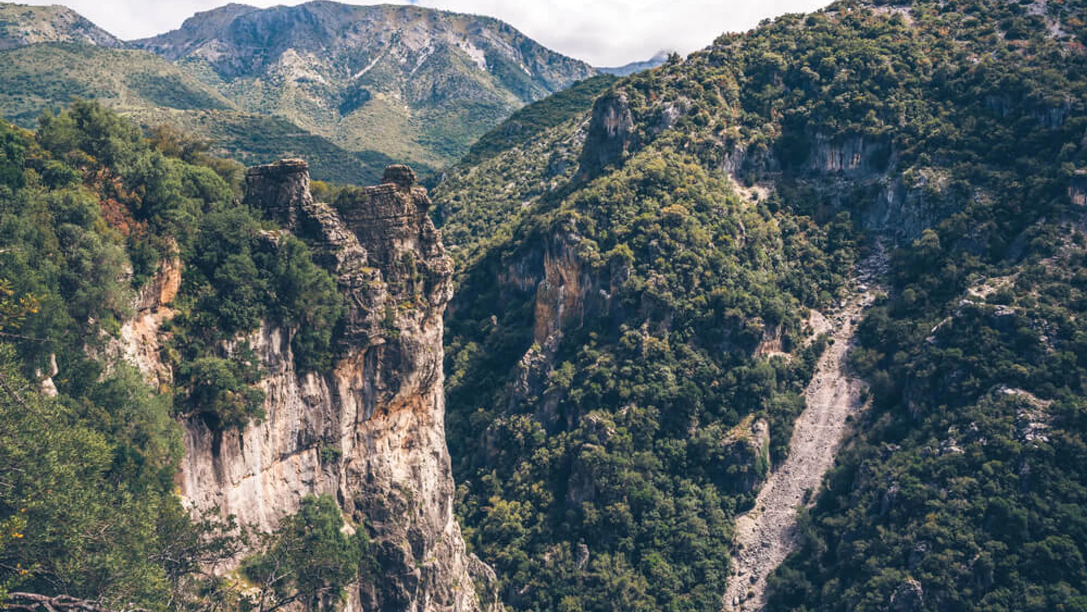
7.Pinsapar of Grazalema: a rare fir forest on a quiet path
The pinsapo, a relic fir, survives on north-facing slopes around Grazalema, Europe’s wettest corner of mainland Spain. The linear Pinsapar route threads the cool, fragrant forest with filtered views over the Sierra. Resin and damp earth perfume the air as light sifts through spire-like crowns.
- Location and access: Cádiz province; starts near Puerto de las Cumbres or from Benamahoma (variants); within Sierra de Grazalema Natural Park.
- Distance and elevation: 10–13 km round trip, +400–600 m depending on start.
- Time estimate: 4–5.5 h.
- Best season: Autumn to spring; summer often has fire-season restrictions.
- Ideal for: Nature lovers, families with teens, botanists.
- Fees/permits: Daily quotas and free permits typically required to enter the core pinsapar; obtain from park offices (El Bosque or Grazalema) or official channels—reserve ahead on weekends/holidays.
- Getting there: Road access from Grazalema or Benamahoma; limited public transport; taxis possible.
- Points of interest: Pinsapo stands, viewpoints toward Sierra del Pinar, possible vulture sightings.
- Notes: Trail etiquette and silence enhance wildlife chances; mud common after rains.
Confirm permit procedures with Junta de Andalucía Natural Park offices; conditions shift with rainfall and fire alerts.
8.Río Borosa (cazorla): canyons, cascades, and emerald pools
The Borosa is a classic day out in the Sierras de Cazorla, Segura y Las Villas Natural Park, starting easy then turning adventurous. Walk riverbanks and wooden walkways to the Cerrada de Elías, then continue to deepening canyons, waterfalls, and hydropower tunnels toward Aguas Negras. The river runs green like blown glass under travertine shelves.
- Location and access: Jaén province; start near the fish farm/visitor area (“Piscifactoría”) close to the A-319.
- Distance and elevation: 16–22 km round trip to Salto de los Órganos/Aguas Negras, +600–800 m; family-friendly option to Cerrada de Elías is ~8–10 km round trip, low gain.
- Time estimate: 3–4 h (family option); 6–8 h (full).
- Best season: Spring for flow and flowers; autumn for light; summer is hot—start at dawn.
- Ideal for: Photographers, families (shorter option), strong hikers (full route).
- Fees/permits: No permit for standard paths; check for temporary closures after storms.
- Getting there: Drive from Cazorla or Arroyo Frío; limited buses to the area—self-drive is simplest.
- Points of interest: Cerrada de Elías walkway, cascades, tunnels (carry a headlamp), Salto de los Órganos waterfall.
Carry 2–3 L of water per person in warm months, and mind slippery boardwalks after rain; confirm current advisories with the Natural Park.
9.La Concha (marbella): a coastal summit with Strait views
La Concha rises behind Marbella like a sentinel, offering a sea-to-peak experience in half a day. From Refugio de Juanar, a well-used path climbs to a rocky crest with airy sections near the top and vast views across Gibraltar to Morocco on clear days. Sea breeze and thyme drift together on the ridge.
- Location and access: Málaga province; typical start at Refugio de Juanar (Ojén).
- Distance and elevation: 12–14 km round trip, +600–800 m.
- Time estimate: 4–6 h.
- Best season: October–May; in summer, go at dawn and avoid midday heat.
- Ideal for: Intermediate hikers, sunrise/sunset chasers, trail runners.
- Fees/permits: None.
- Getting there: Drive from Marbella or Ojén; limited public transport—taxis feasible from Marbella.
- Points of interest: Cruz de Juanar, knife-edge sections (non-technical but exposed in places), Strait of Gibraltar and Rif views.
Pack sun protection even in winter, and keep children close on the final crest; rock is polished in spots from traffic.
10.Chestnut Trails of Sierra de Aracena: easy loops with flavor
In Huelva’s Sierra de Aracena, chestnut groves stitch villages together with soft paths and stone lanes. Choose circular routes between Aracena, Linares, Los Marines, and Fuenteheridos for a gentle day among orchards and fountains. Fallen husks crunch underfoot as wood smoke drifts from whitewashed hamlets.
- Location and access: Huelva province; multiple trailheads in Aracena, Los Marines, Fuenteheridos, Castaño del Robledo.
- Distance and elevation: 8–16 km loops, +200–500 m, depending on villages linked.
- Time estimate: 2.5–5 h.
- Best season: Autumn for color and chestnuts (respect private groves), spring for flowers and mild temperatures.
- Ideal for: Families, food-minded hikers, casual walkers.
- Fees/permits: None; parking may be regulated in village centers.
- Getting there: Buses from Seville to Aracena; easy driving on N-433.
- Points of interest: Dehesa landscapes, chestnut orchards, cured Iberian ham producers, village plazas and bakeries.
- Notes: Combine with visits to the Gruta de las Maravillas (Aracena’s show cave) and local markets.
Use waymarked lanes and respect gates and crop boundaries; these are working landscapes tended by local families.
Interactive Map to Plan and Navigate
You can filter the interactive map by difficulty, season, family-friendly picks, or deep mountain routes. Each pin bundles start points, recommended parking, water sources, refuges/shelters, viewpoints, and caution areas like exposed ridges or flood-prone narrows. A thin blue line on screen becomes a confident line underfoot.
- Save
GPX/KMLtracks to your phone and open them in a maps app that supports offline use. - Tap to view coordinates, parking details, and notes; copy them to your car nav for turn-by-turn access.
- Use the “layer” toggle to reveal public transport stops near trailheads where available.
Before leaving service, download the area tiles and the GPX file, and cross-check with official park advisories for seasonal rules.
Choosing the Right Route for Your Day
Match your route to fitness, time, weather, access, and your group. A clear morning at altitude can turn stormy by afternoon, and a shady river can be unsafe after rain. Pine scent and cool air are delightful; running water after storms is not.
- Fitness and time:
- New to hills, 2–4 h available: Los Cahorros, Chestnut Trails, short Torcal loops.
- Intermediate, 4–6 h: La Concha, full Los Cahorros loop, extended Torcal Yellow route.
- Strong, 6–8 h: Río Borosa full, Mulhacén (south approach), Veleta.
- Weather windows:
- Hot day: Río Chillar, early/late La Concha, Torcal at dawn; carry extra water and sun protection.
- Windy/cold: Torcal (check fog), Chestnut Trails, Los Cahorros; avoid high Sierra crests.
- Access:
- No car: Caminito del Rey (train + shuttle), Granada bus to Monachil, Seville bus to Aracena (then taxi).
- Car: All routes; parking rules vary—use signed lots.
- Group composition:
- Young kids: Short Torcal loop, Los Cahorros out-and-back to first bridge, Chestnut Trails.
- Dogs: Check park rules; leashes often required, and Caminito del Rey does not admit pets.
- Experts: Mulhacén/Veleta in shoulder seasons with snow skills; always carry proper gear.
Pre-departure checklist:
- Forecast and park advisories checked.
- Route distance/elevation matched to your window and group.
GPXsaved offline, spare battery packed.- Water: 0.5–1 L per hour in heat; electrolytes on long days.
- Sun, wind, and rain layers; headlamp, basic first-aid, whistle.
- Transport/parking confirmed; tickets/permits secured where applicable.
For example, if you’re torn between Mulhacén and Río Chillar on a hot July weekend, choose Chillar for safety and enjoyment; save Mulhacén for a crisp September dawn.
Practical Tips and Safety in the Mountains
Good planning turns beautiful terrain into a good day; poor planning turns it into a rescue call. Andalusia blends alpine altitude with Mediterranean heat, so adjust accordingly. The warmth on your back can hide dehydration until your legs go heavy.
- Navigation and planning:
- Download map tiles and
GPX; carry a paper map/compass as backup on high routes. - Share your plan and return time with someone at home.
- Download map tiles and
- Weather:
- Check AEMET mountain forecasts for Sierra Nevada and local park bulletins.
- In summer, start at dawn and seek shade/water routes; in winter, expect ice above 2,500 m.
- Gear basics:
- Footwear with grip (water shoes for Chillar, boots or sturdy trail shoes elsewhere).
- Sun hat, sunglasses, SPF 50, windproof layer; in shoulder season, add insulating layer and gloves.
- 2–3 L water per person on hot days; snacks with salt and carbs.
- Headlamp, phone in airplane mode to save battery, small first-aid kit.
- Local signage and rules:
- Respect waymarks and seasonal closures; Caminito del Rey has strict entry rules and equipment checks.
- Pinsapar quotas protect a rare forest—carry your permit and ID if required.
- Risks to note:
- Heat stress June–September below 1,500 m.
- Flash floods in riverbeds (Chillar, Borosa) after heavy rain.
- Altitude and sudden storms in Sierra Nevada.
- Behavior:
- Follow Leave No Trace: pack out waste, stay on trails, keep noise low, and never light fires.
If a forecast trends worse overnight, switch to Torcal’s short loop or a Chestnut Trail and keep the big mountain for another day.
Important
In summer, plan 1 liter of water per person for every 2 hours, more on exposed routes. If signs warn of closure (fire risk, storms, overcrowding), respect them and choose an alternative from the list.
Getting There, Staying Local, and When to Hire a Guide
Andalusia is well-connected: Málaga (AGP) and Seville (SVQ) are the main gateways, with Granada (GRX), Jerez (XRY), and Almería (LEI) as secondary options. High-speed trains serve Málaga María Zambrano and Sevilla Santa Justa, with regional links to Granada and Cádiz. The metallic hum of rails gives way to cicadas as you step into the hills.
- Transport:
- Without a car: Caminito del Rey is the easiest (train to El Chorro + shuttle). Granada buses reach Monachil; Seville buses run to Aracena.
- With a car: All trailheads are reachable; parking varies from large lots (Torcal, Borosa) to village edges (Monachil, Aracena).
- Rural stays and food:
- Base near Granada for Sierra Nevada hikes and Los Cahorros.
- Antequera or Málaga for Torcal and Caminito del Rey.
- Nerja for Río Chillar; Cazorla/Arroyo Frío for Borosa; Aracena for chestnut routes.
- Look for ventas and village markets to refuel—your euros help keep these communities vibrant.
- Guides:
- Consider certified local guides for winter ascents in Sierra Nevada, first-time summit attempts, and geology/botany interpretation in Torcal or Grazalema.
- Reservations:
- Book Caminito del Rey tickets well in advance.
- Secure Pinsapar permits through the Natural Park.
- In peak summer weekends, Torcal parking may switch to shuttle—confirm hours on the Visitor Centre’s channels.
For more route ideas and to match activities with your dates, check curated options and confirm current schedules before you set off.
Frequently Asked Questions
Soft morning light is kind to both photos and crowds, and it leaves time for a village lunch after your hike.
What is the best time of year to hike in Andalusia?
Spring (March–May) and autumn (late September–November) offer mild temperatures and clear light almost everywhere. Summer suits water routes like Río Chillar and early/late ridge hikes; winter is fine at low elevations and the time for snow-aware days in Sierra Nevada.
Are these routes suitable for children?
Yes, several: Los Cahorros (first bridges), Torcal Green route, and Chestnut Trails are family-friendly. Río Chillar is excellent in summer for confident walkers—mind slippery stones and always supervise.
Do I need permits or tickets?
Caminito del Rey requires advance tickets; carry ID. The Pinsapar of Grazalema typically needs a (free) daily permit due to quotas. Sierra Nevada hikes generally do not need permits, but access roads and bus services (e.g., SIAC) may require reservations.
Where can I Park?
Most routes have signed car parks: Torcal Visitor Centre, Borosa “Piscifactoría,” Juanar for La Concha, village edges in Monachil and Aracena. On peak days, expect controls or shuttles; arrive early.
How do I read difficulty levels?
Check distance, elevation gain, terrain, and exposure together. For example, 12 km on smooth chestnut lanes is easier than 12 km at altitude on rocky trails; use our route facts and match them to your fitness and available time.
Can I go by public transport?
Yes, selectively: Caminito del Rey (train + shuttle), Granada to Monachil (local bus), Seville to Aracena (regional bus, then taxi). Most mountain trailheads are best by car or taxi from nearby towns.
Book your experience — explore active nature experiences in Spain with Picuco-verified providers.
Conclusion
From Mulhacén’s sky-touching ridge to Torcal’s fossil sea and Aracena’s chestnut shade, these 10 walks capture Andalusia’s breadth. You can pick alpine air, river coolness, karst horizons, or village-to-village quiet, all within a few hours of Málaga, Seville, or Granada. Evening swallows trace loops over white villages as boots unlaced, day done.
Choose a route that suits your group and the forecast, download the GPX, and set an early alarm to walk in the best light. Save this list, share it with your hiking circle, and tell us what you discover—your notes help others hike better and support the communities that care for these landscapes. If a plan falls through, pivot to the quick alternatives above and keep the mountains kind and safe for your next visit.