Why Choose Easy Summer Hikes in the Pyrenees
Choose Pyrenees summer hikes that keep things simple, scenic, and safe. Summer brings long days and open high trails, but it also means heat, sudden storms, and popular valleys that fill fast. Expect wide, well-marked paths, clear landmarks like waterfalls and mountain lakes, and logistics that work for families and first-timers.
A light breeze through pines and the sound of water on rock cool the midday sun. We selected eight accessible hikes using practical criteria you can trust:
- Duration: 1.5–6 hours round trip (with options to shorten).
- Elevation gain: up to 600 m on the longest, with several <300 m.
- Clear trail: signposted paths, popular routes, and obvious landmarks.
- Access: public transport where available, or reliable summer parking.
- Shade and water: forest sections, streams, and mountain lakes where breaks are easy.
- Scenery: glacier-carved cirques, waterfalls, and classic mountain lakes (ibones/lacs).
This article gives you concise route facts (distance, ascent, how to get there), safe timing tips (start early, watch forecast), and simple alternatives if you want to shorten. You can scan the quick summary to choose a match, then dive into each route’s details to plan. For updated rules and any seasonal restrictions, check official park pages like Parc National des Pyrénées (parc-pyrenees.fr) and Parque Nacional de Ordesa y Monte Perdido (miteco.gob.es/parques-nacionales/ordesa-monte-perdido). Go steady, drink often, and prioritize shade at midday.
Picuco te puede ayudar
Does something here catch your eye?
Tell us.
Write to us on WhatsApp or email: we answer questions, find the best options and help you sort out the booking.
The Eight Routes at a Glance
- Cirque de Gavarnie (Hautes-Pyrénées): wide valley track to a famous waterfall; great for families and photographers on cool mornings.
- Ordesa Cola de Caballo (Huesca): long but non-technical valley walk past waterfalls; ideal for fit beginners who start early.
- Ibón de Piedrafita (Valle de Tena): gentle climb on a clear path to a quiet lake; perfect for picnics and families.
- Ibón de los Baños, Panticosa: easy lakeside loop at the historic spa; great if you want short walks with services nearby.
- Lac d’Ilhéou (French Pyrenees): steady ascent on a good path to a classic alpine lake; best for active families and walkers used to hills.
- Lac de Gaube (near Cauterets): famous blue lake via trail or summer lift; excellent for strollers if you use the cable.
- Valle de la Ripera (Panticosa): low-gradient valley tracks with shade and streams; made for family-friendly rambles.
- Ibón de Estanés (near Somport): border lake via beech forest and meadows; rewarding long walk without technical steps.
Best picks by profile:
- Families with young kids: Ibón de los Baños, Valle de la Ripera, Lac de Gaube (with lift).
- Short scenic stroll: Gavarnie to viewpoints, Panticosa lakeside.
- Lake lovers: Ibón de Piedrafita, Lac de Gaube, Ibón de Estanés.
Pyrenees Summer Hikes: 8 Accessible Routes
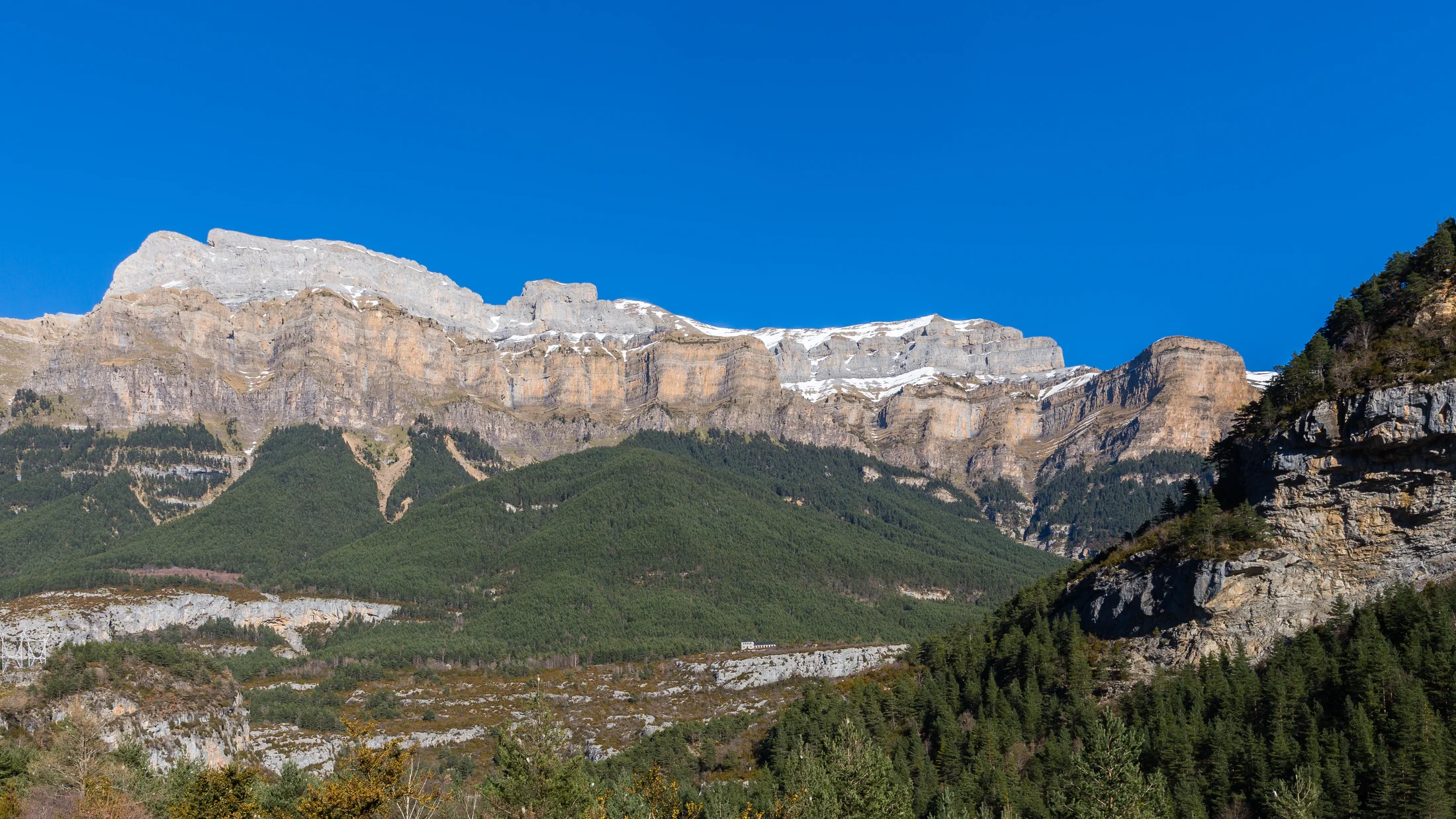
Cirque de Gavarnie: glacier amphitheatre and iconic waterfall
Start with a classic that feels big but stays simple. The Cirque de Gavarnie sits in the French Hautes-Pyrénées, with access from the village of Gavarnie (42.737°N, -0.007°E) where you’ll find paid parking in summer (typically 5–8 €; confirm locally). A broad track follows the valley to the Hôtel du Cirque, then a final stony section reaches the viewpoint below the 422 m waterfall.
Cool spray drifts across the meadow as the cirque walls glow in morning light. Families and photographers love this route because the path is obvious, water is near, and the scenery builds naturally as you walk. Plan 9–11 km round trip, 200–300 m ascent, and 3–4.5 hours depending on where you turn around. Go early to avoid heat and crowds; shade increases closer to the back of the valley.
Practical tips:
- Terrain: compacted track then rocky path; sturdy walking shoes are enough.
- Safety: in fog or heavy spray, keep distance from the waterfall base—rocks get slick.
- Services: cafés in the village; carry 1–1.5 L water per person.
- Transport: regional buses serve Gavarnie in season from Luz-Saint-Sauveur/Cauterets; check timetables at hautespyrenees.fr.
This is one of the easy Pyrenees trails that delivers a huge payoff without exposure or tricky footing.
Ordesa Cola de Caballo: a classic, accessible valley walk
You can hike to Ordesa Cola de Caballo on a long, non-technical path that strings together terrace-like waterfalls. The route begins at La Pradera de Ordesa (42.646°N, -0.052°E) in the Ordesa y Monte Perdido National Park (Huesca). In peak summer, private car access is restricted; a mandatory shuttle bus runs from Torla-Ordesa (check current fees and schedules on miteco.gob.es/parques-nacionales/ordesa-monte-perdido and torla.es).
White water rumbles through beech forest as sunlight flickers green overhead. From La Pradera, follow the valley floor past Cascadas de Arripas, Estrecho, and the Gradas de Soaso to the Cola de Caballo waterfall, then return the same way. Expect 16–18 km round trip, 500–600 m ascent, and 5–7 hours. The path is clear and well-graded, but it’s a long day—start at dawn, rest in shade, and pace snacks and water.
Logistics and safety:
- Terrain: packed dirt and stone steps; walking shoes or light boots are fine.
- Sun and water: carry 2 L water per person; refill only at signed potable sources.
- Crowds: the valley fills between 10:00–15:00; go before the first shuttle or after 16:00 for quieter light.
- Rules: stay on path, respect closures, and pack out all waste in this protected area.
This is among the most accessible hikes Pyrenees-wide for fit beginners who want waterfalls, strong waymarking, and big-valley drama—without technical gear.
Ibón de Piedrafita, Valle de Tena: a tranquil, family-friendly lake
Pick Ibón de Piedrafita for a half-day that suits kids and easygoing walkers. The trail starts near Piedrafita de Jaca (42.688°N, -0.334°E) in the Valle de Tena, with signed parking on a track above the village. Parking is generally free in summer; arrive early for space and to avoid dust on the approach track.
Larks rise over limestone walls while the lake lies like a dark-blue coin. From the car park, a well-marked path climbs gently through scattered pines and meadows to the ibón. Plan 6–8 km round trip, 250–350 m ascent, and 2–3 hours depending on breaks. Families appreciate the steady gradient, broad picnic spots, and the clear goal: water and big views.
What to know:
- Terrain: mostly dirt track and singletrack; trainers with grip are fine.
- Sun: shade is patchy—wear a hat and apply high-SPF sunscreen often.
- Water and food: no services on the route; pack a picnic and 1–1.5 L water per person.
- Swimming: very cold; only enter if permitted by local signage and conditions.
For routes labeled family-friendly hikes Pyrenees visitors love, this checks every box: clear, short, scenic, and calm.
Ibón de los Baños, Panticosa: lakeside walking with spa heritage
When you want short, scenic, and service-rich, head to the Balneario de Panticosa. You can drive to the high spa complex and Ibón de los Baños (42.756°N, -0.238°E) via the mountain road from Panticosa village; summer parking is usually free but limited near the lake. The level path loops the lake and links historic buildings, bridges, and cascades.
Pine-scented air drifts over quiet water as granite reflects the sky. This is a choose-your-own-length stop: stroll the lakeside (1–2 km, <50 m ascent), add short spurs to nearby viewpoints, or extend into the upper valley if energy allows. It’s ideal for multigenerational groups and for hot afternoons when you want shade and benches.
Useful details:
- Terrain: paved and packed-dirt paths; prams handle part of the loop.
- Services: cafés, public toilets, and paid thermal facilities in the spa complex (check opening hours and prices locally).
- Timing: arrive early on weekends; afternoon thunderstorms are common—heed forecasts and shelter in buildings if needed.
- Alternatives: the summer cable car in Panticosa town serves hiking on the ski domain, but it is separate from the Balneario area.
List this among easy Pyrenees trails that pair nature with history and comfort.
Lac d’ilhéou: an alpine lake from the French side
Choose Lac d’Ilhéou when you’re ready for a steady but well-built climb. Start from the Cambasque area above Cauterets, where signed parking fills fast in summer (check visitor info at cauterets.com). The path to the lake and refuge is clear and popular, with steps and switchbacks that ease the gradient.
Cool air flows off granite slabs while the lake mirrors jagged peaks. Count on 8–10 km round trip, 600–700 m ascent, and 3.5–5 hours depending on pace. It’s not stroller-friendly, but it remains non-technical; families with hiking experience or older kids often enjoy the challenge. You can turn around at lower meadows if heat or time suggests an earlier return.
Plan smart:
- Terrain: rocky mountain path with engineered steps; light boots recommended.
- Water and shade: beech and pine sections offer shade low down; carry 1.5–2 L water per person.
- Weather: afternoons build storms—start early and be below treeline by mid-afternoon.
- Parking: arrive before 9:00 on weekends; carry coins or card for any local parking fees.
Among accessible hikes Pyrenees lovers recommend, Ilhéou sits at the “easy-moderate” edge—rewarding, straightforward, and memorable.
Lac de Gaube: a signature blue lake (with optional lift)
If you want a famous view without a big effort, Lac de Gaube near Cauterets delivers. Drive to the Pont d’Espagne parking (42.853°N, -0.132°E) and either walk the well-made trail or use the summer gondola and chairlift to shorten the climb. Return lift fares for adults typically range 17–20 €; confirm schedules and prices on cauterets.com.
Water ripples glass-green as cascades chatter through pine shade. On foot, expect 6–8 km round trip, 200–300 m ascent, and 2.5–3.5 hours on a rocky but obvious path. With the lifts, it becomes a short stroll suitable for small children and relaxed walkers. The lakeshore offers flat spots for picnics and framed views of Vignemale.
Key notes:
- Terrain: stone-paved sections and rocks; sturdy trainers are fine.
- Crowds: arrive before the first lift or late afternoon for quieter shores.
- Safety: supervise kids near water and slippery rocks; sudden gusts ripple the surface.
- Services: cafés near Pont d’Espagne and in high season by the lake; carry cash/card.
For Pyrenees summer hikes that feel cinematic yet accessible, Gaube is a first choice.
Valle de la Ripera: gentle valley routes outside Panticosa
Unwind on valley-floor tracks where shade and streams set the pace. The Valle de la Ripera begins above Panticosa village, accessible by a forest track that hikers and authorized vehicles share (respect local signs and closures). Parking is limited near the valley entrance; on busy days, start from the village to add a gentle warm-up.
A cool ribbon of water slides over stones while cowbells echo against grassed slopes. Typical family-friendly options include:
- Short valley amble: 5–7 km round trip, <150 m ascent (2–2.5 hours).
- Meadow loop to a low viewpoint: 8–10 km round trip, 200–300 m ascent (3–4 hours).
Why it works in summer:
- Shade: mixed forest and high-sided valley keep things cooler.
- Water: streams for cooling feet; drink only from signed potable sources.
- Flexibility: turn back anywhere; add distance only if energy stays high.
Logistics and respect:
- Carry 1–1.5 L water per person, sun hats, and a light rain layer.
- Cattle and sheep graze here—keep dogs leashed and give animals wide space.
- Check Panticosa tourist info for up-to-date access notes and any forestry works.
These are truly accessible hikes Pyrenees visitors of all ages can enjoy together.
Ibón de Estanés: a border lake with rolling meadows
Choose Ibón de Estanés if you want a longer, non-technical day with a big-lake finish. The most popular start is the French Sansanet car park near the Somport tunnel (42.787°N, -0.524°E), where the path climbs through beech forest to pastoral meadows and the Spanish border. Parking is free; arrive early on weekends.
Wind ripples grass as the lake’s blue rim appears beyond limestone folds. Plan 11–13 km round trip, 500–600 m ascent, and 4–5.5 hours at a steady pace. The trail is clear and well-graded; waymarks guide you across open pastures where flocks and shepherds share the path. Pack lunch and enjoy a long break by the shore.
Good to know:
- Terrain: forest track to mountain path; no exposure, some rocky steps.
- Water: streams en route; treat or avoid unless signed potable.
- Weather: storms form quickly—start early and watch the sky.
- If you’re based in Benasque: consider a similar, non-technical lake day to Ibón de Batisielles from
Baños de Benasque(check local info for distances and parking).
This sits high on any list of mountain lakes Pyrenees fans remember—grand, calm, and welcoming to patient walkers.
Map of Locations
Use an interactive embed that pins the eight trailheads and key parking areas. Include coordinates like La Pradera de Ordesa: 42.646°N, -0.052°E, Gavarnie village: 42.737°N, -0.007°E, and Pont d’Espagne: 42.853°N, -0.132°E. If you prefer a static image, add numbered markers and a simple legend for accessibility—green (short/easy), amber (moderate length), red (long but non-technical).
A line of blue pins across the range helps you picture a multi-day circuit. Add estimated drive times between clusters (e.g., Panticosa ↔ Cauterets ~1.5–2 hours via border crossings; Torla-Ordesa ↔ Panticosa ~1–1.5 hours). Readers can tap each pin for:
- Parking and public transport notes.
- Distance/ascent and typical time windows.
- Seasonal tips (lifts running, shuttle buses, crowding).
Combine nearby options—Panticosa (Ibón de los Baños, Ripera, Piedrafita) or Cauterets (Gaube, Ilhéou)—to minimize driving.
How to Choose the Right Route
Start with time and temperature, then match distance and ascent to your real capacity. Summer heat and afternoon storms mean earlier starts, generous shade breaks, and honest pacing. If you have four hours total, choose a 2–3 hour hike and leave buffer for rests and photos.
A breeze through the trees is your green light; baking rock slabs mean it’s time to turn around. Evaluate:
- Duration you truly have (door-to-door).
- Elevation you tolerate in heat (200–600 m).
- Shade and water (forest, streams, lakes).
- Logistics (parking space, shuttles, lift hours).
- Shortening options (turnarounds, lift down).
Two quick comparisons:
- Lac de Gaube vs. Cirque de Gavarnie: Gaube is shorter, shadier early, and can be made very easy with lifts—choose it for young kids or hot days. Gavarnie offers a bigger amphitheatre feel with gentle gradients—pick it for families who can handle a 3–4 hour valley walk and want the iconic waterfall.
- Ibón de Piedrafita vs. Ordesa Cola de Caballo: Piedrafita is a 2–3 hour family outing with a manageable climb and picnic-friendly lake; perfect if you have half a day. Ordesa is a rewarding but long valley hike—choose it only if you start early, carry enough water, and are comfortable with 16–18 km.
Adjust for weather:
- If the forecast shows afternoon storms, start at sunrise and plan to be descending by midday.
- If a heat wave hits, stick to shaded valleys (Ripera), short lakeside loops (Panticosa), or ride lifts (Gaube) to cooler elevations.
- Always confirm summer shuttle/lift timetables the evening before.
Practical Tips for Summer Hiking in the Pyrenees
Summer rewards the prepared walker who starts early and carries light, smart layers. The Pyrenees mix sun-exposed rock with cool forests and sudden cloudbursts, so flexibility keeps things safe and enjoyable.
The scent of warm resin turns to damp earth as thunderheads drift over ridgelines. Use these actionable tips:
- Sun and heat: apply SPF 30–50 every two hours, wear a brimmed hat, and rest in shade often.
- Hydration: drink small sips steadily; carry 1–2 L per person on shorter routes, 2–3 L on longer days.
- Clothing: light, breathable layers; quick-dry shirt, shorts or light trousers, and a compact rain shell.
- Timing: avoid 12:00–16:00 for exposed sections; start at sunrise when trails and parking are quiet.
- Storms: if thunder approaches, descend from ridges and isolated trees; shelter safely away from water and metal structures.
- Kids: keep a steady snack rhythm, set turnaround times, and celebrate small milestones at streams or viewpoints.
- Pastures: pass calm cattle widely, avoid calves, and keep dogs on lead.
- Parks: stay on marked paths, respect closures, and carry out all waste; drones are often restricted.
Basic checklist:
- Footwear with grip, map or offline app, charged phone, sun hat, sunglasses.
- Water, snacks, small first-aid kit, light rain jacket, and warm layer if a lift is involved.
- Cash/card for parking, shuttles, or cafés.
In peak season, reserve shuttles or lifts when possible and arrive at car parks by 8:30 to secure a spot.
Frequently Asked Questions
Do I need permits for these hikes?
For the routes listed, no advance hiking permit is required. In Ordesa y Monte Perdido, summer access to La Pradera uses a mandatory shuttle bus from Torla—buy tickets on-site or via official channels announced by Torla-Ordesa and MITECO (miteco.gob.es/parques-nacionales/ordesa-monte-perdido). Always check park notices before travel.
Is parking free, and how much do shuttles or lifts cost?
Village and trailhead parking varies: some are free (Sansanet for Estanés, often Panticosa Balneario), while others charge (Gavarnie village, Pont d’Espagne). Summer lifts to Lac de Gaube typically cost 17–20 € return for adults; Ordesa shuttles have modest fares. Confirm current prices on cauterets.com, torla.es, and local tourism boards.
Are these routes suitable for small children?
Yes, with the right choices: Ibón de los Baños (lakeside loop), Valle de la Ripera (short valley rambles), and Lac de Gaube (use the lift) are best for small kids. Gavarnie suits families used to 2–3 hour walks. Ordesa Cola de Caballo and Estanés are long days—choose them for older kids who have hiked similar distances.
What is the best time of day to start in summer?
Start early—ideally around sunrise. You’ll enjoy cooler temperatures, easier parking, and quieter trails. Aim to be descending by early afternoon when heat and storms are more likely. For evening light, short options like Panticosa lakeside or Gavarnie’s lower viewpoints work well.
What if the weather changes suddenly?
If clouds build, winds rise, or you hear thunder, descend to lower, forested ground and avoid ridgelines and isolated trees. Put on a rain shell, pack electronics away, and wait out showers safely. Check forecasts the night before and again in the morning; MeteoFrance, AEMET, and local park bulletins are reliable sources.
Is there potable water on the routes?
Assume streams are not drinkable unless signed as potable. In Ordesa, look for marked fountains near La Pradera. In villages and major car parks (e.g., Pont d’Espagne, Gavarnie), you’ll usually find taps or services. Carry enough water from the start: 1–1.5 L for short strolls, 2–3 L for longer hikes.
How do I navigate—are trails well-marked?
These routes are popular and well-signed, with clear landmarks like waterfalls and lakes. Still, bring a map or an offline app and note key coordinates such as Pradera de Ordesa: 42.646°N, -0.052°E and Sansanet: 42.787°N, -0.524°E. Waymarks and cairns help above the treeline; follow established paths to reduce erosion.
Can I swim in the lakes?
Swimming is cold and sometimes restricted. Always follow posted signs and local advice—some protected lakes prohibit bathing to protect fragile ecosystems. If swimming is allowed, enter carefully from stable rocks and keep away from outflows.
Book your experience — discover active nature activities in Spain with providers verified by Picuco.
Conclusion
Pick your route to match your day, your group, and the forecast. For an effortless family afternoon, try Ibón de los Baños or Valle de la Ripera; for a classic photo walk, Lac de Gaube or Cirque de Gavarnie shine when you start early. Keep plans flexible, carry water and shade, and respect trails shared by wildlife, shepherds, and fellow hikers.
A last breath of pine and cool stream air stays with you long after the drive home. If this sparked ideas, save these routes and sketch a two- or three-day loop by clustering valleys. Travel light, leave no trace, and enjoy the long light of summer with simple, memorable mountain days.