Why These Summits Make Sense If You’re Not an Alpinist
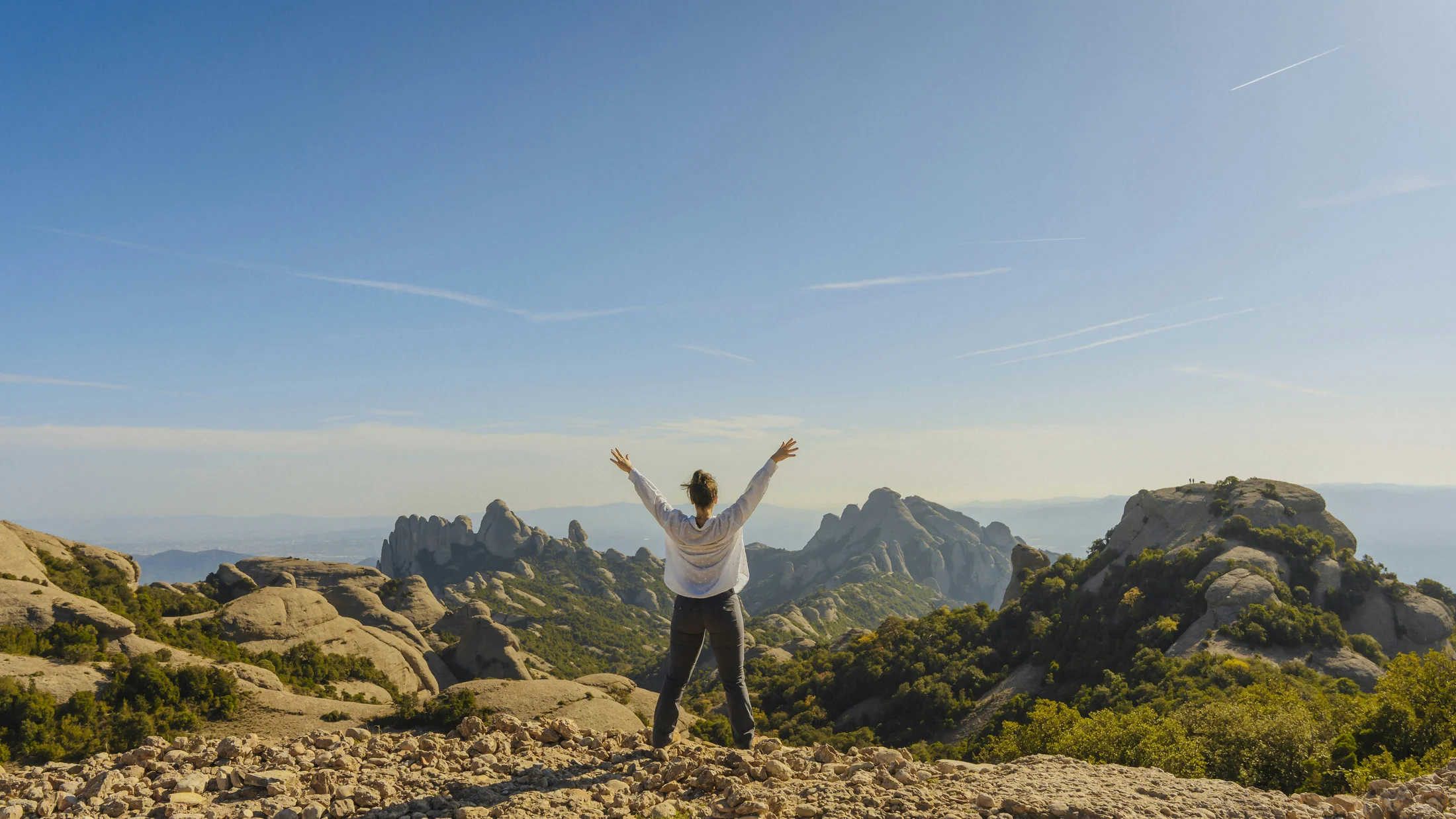
If you dream of high mountain trekking Spain but don’t want ropes or ice axes, you’re in the right place. We’ve selected 10 affordable ascents—“affordable” in effort, skills, and budget—so confident hikers can reach serious summits without technical climbing. Picture sunrise light washing over old glacial bowls and long ridgelines as cool air lifts the scent of pine.
We built this list using clear criteria you can trust: safe routes with established paths, reasonable elevation gain (generally 400–1,200 m), no mandatory technical steps, and reliable access with nearby services. We also weighed cost (typical public transport or fuel, modest lodging, optional guide fees), weather patterns, and the presence of escape options if conditions turn. You’ll find peaks from Sierra Nevada to the Pyrenees and the Canary Islands, including well-known names like Peñalara and Mulhacén and quieter gems such as La Sagra.
This article is for hikers with good fitness and prior mountain day-hike experience, but without alpinism training. You should be comfortable on uneven terrain for 5–9 hours, know basic navigation, and manage layers in changeable weather. If you’re seeking an easy summit Spain experience or trekking without technical climbing, these choices give you altitude, views, and challenge—minus the rope work.
Here’s what’s inside: a quick definition of what makes an ascent “affordable” in the high mountains, an interactive map with filters, concise one-line summaries for each summit, and detailed route fiches to help you plan time, budget, and logistics. You’ll also get practical selection advice, an equipment and safety checklist, money-saving tips, and clear FAQs. Use this as your planning base, then fine-tune dates, weather windows, and bookings at your own pace.
Picuco te puede ayudar
Does something here catch your eye?
Tell us.
Write to us on WhatsApp or email: we answer questions, find the best options and help you sort out the booking.
What We Mean by an “affordable” High-mountain Ascent
Affordable, in this context, means within reach for fit hikers who are not alpinists, both technically and financially. In technical terms, these routes require no rope use, no exposure to mandatory climbing moves, and no glacier travel; winter exceptions apply, when snow and ice may demand crampons and an ice axe. Think well-marked or well-trodden paths where the risk of a simple navigation error is lower, and rescue statistics are not disproportionately high. A raw breeze on a saddle and the crunch of grit under boots remind you the environment is real but manageable.
Duration typically ranges 3–9 hours round trip, with 400–1,200 m of elevation gain and distances in the 8–18 km band. Terrain includes rocky steps, scree (loose gravel-like rock), and sometimes easy “scrambling” where you may use hands for balance, but without exposure that would oblige rope skills. Expect mountain weather: cool mornings, strong sun at altitude, and wind on ridges; storms can develop fast, especially in summer afternoons.
High-mountain trekking differs from alpinism in that you stay on hiking terrain and avoid technical walls, ice, or mixed ground. Hire a qualified guide if you’re unsure about navigation, if forecast shows marginal conditions, if the route includes unprotected rock moves beyond your comfort, or in snow season. A guide can also optimize pacing, breaks, and route choices.
You’re responsible for your preparation: check forecasts from official agencies (AEMET in Spain), carry suitable layers, food, and water, and set turnaround times. If in doubt, step down in ambition. No summit is worth an avoidable risk, and the mountain will be there tomorrow.
Where They Are: Interactive Map and One-line Summaries
You’ll find an interactive map with all 10 summits geolocated and filterable by difficulty, best season, and province. Toggle layers to view public transport hubs, parking areas, and nearby rural lodging; switch to terrain or satellite to visualize slope angles and ridge lines. A downloadable GPX bundle and a printable overview are included so you can plan offline. A single scroll and a few taps help you shortlist a peak close to your base. A thin blue line over grey contours shows each path like a river drawn on the hillside.
Quick summaries (one-liners per summit):
- Peñalara (Sierra de Guadarrama, Madrid/Segovia): Classic 2,428 m path from
Puerto de Cotos, 4–6 h RT, ideal near Madrid. - Pico del Lobo (Ayllón, Guadalajara/Segovia): Friendly ridge to 2,272 m from
Puerto de la Quesera, 4–5 h RT. - Mulhacén (Sierra Nevada, Granada): Spain’s peninsula high point, non-technical via Loma del Mulhacén, 7–9 h RT.
- Veleta (Sierra Nevada, Granada): 3,398 m with high road access from
Hoya de la Mora, 4–6 h RT. - Puigmal (Eastern Pyrenees, Girona): From Vall de Núria, steady 2,913 m ascent, 5–7 h RT.
- Pico Almanzor (Gredos, Ávila): Granitic 2,592 m with short easy scrambles near the top, 7–9 h RT.
- Pico de las Nieves (Gran Canaria): Island high point, modular walks from Cruz de Tejeda/Roque Nublo, 2–5 h RT.
- Moncayo (Zaragoza/Soria): Historic 2,316 m walk from the Sanctuary car park, 4–5 h RT.
- Pico Urbión (Soria/Burgos): Laguna Negra to 2,228 m, 3–5 h RT, lakes and pinewoods.
- La Sagra (Granada): Isolated 2,383 m cone from Puerto de la Sagra, 5–7 h RT, big views and quiet slopes.
The 10 Most Accessible High-mountain Ascents in Spain
1.Peñalara: glacial lagoons and an approachable ridge
Reach 2,428 m on the skyline of the Sierra de Guadarrama via a well-maintained path from Puerto de Cotos (1,830 m), with 600–700 m ascent and 12–14 km round trip in 4–6 hours. Choose the classic loop via Laguna Grande and the Claveles ridge bypass, or shorten by out-and-back to the summit without rim traverses. Pine resin scents the air while granite crunches softly underfoot.
- Location and access:
Puerto de Cotoson theCL-601/M-604, 1 h 30 min by car from Madrid; Cercanías rail + bus combos run seasonally to Cotos—check timetables. - Difficulty: Non-technical; clear signage inside Sierra de Guadarrama National Park; avoid cornices and icy patches in winter.
- Costs (indicative): Public transport Madrid–Cotos 10–20 € return; fuel/tolls 20–35 €; rural rooms in Rascafría or Cercedilla 50–110 € per night; no permit fees.
- Best season: Late spring to autumn; in winter you may need microspikes or crampons depending on ice.
- For whom: First high-mountain outing near Madrid; families with teens; hikers seeking easy summit Spain without exposure.
- Extras: Laguna de los Pájaros viewpoint, mountain cafés at Cotos; consider the Cares Gorge route in Picos de Europa another weekend for a non-summit classic.
Safety note: Weather turns fast—set a turnaround time and avoid the narrow Claveles ridge when snow lingers. For trekking alta montaña España in winter, carry proper traction or postpone.
2.Pico del Lobo: a Central System classic with wide horizons
At 2,272 m, Pico del Lobo crowns the Sierra de Ayllón with a broad, friendly ridge accessed from Puerto de la Quesera (~1,700 m). Expect 550–650 m ascent, 11–13 km, and 4–5 hours round trip on a straightforward path. A cool wind carries the scent of juniper across rust-red schists.
- Location and access: Border of Segovia and Guadalajara; reach
GU-187to Puerto de la Quesera or start from Cantalojas for a longer day. - Difficulty: Easy mountain trail, moderate slopes; in winter, snowdrifts can hide the path.
- Costs: Fuel from Madrid 20–40 €; rural stays near Riaza or Cantalojas 45–100 €; bus to Riaza then taxi (arrange ahead) if car-free.
- Best season: Late spring to autumn; winter can be feasible with snow gear and experience.
- Why it’s accessible: Gentle gradients and open terrain make navigation intuitive in good visibility; it’s among the routes alta montaña accesibles from central Spain.
- Summit rewards: Views to the Sierra de Guadarrama and the old ski area ruins; quiet midweek.
Tips: If forecasts predict icy north slopes, carry microspikes; consider a shorter variant to Collado del Aventadero if winds exceed comfort levels.
3.Mulhacén: the peninsula’s highest summit by path
Mulhacén (3,479 m) offers a non-technical summit via the long Loma del Mulhacén from the Alpujarra side. From Hoya del Portillo or Capileira, reach Alto del Chorrillo, then follow a steady slope to the top: 1,100–1,300 m ascent, 16–22 km, 7–9 hours RT. The air thins as thyme and sun-warmed slate release a dry mountain scent.
- Access: From Granada to the Alpujarra villages (Pampaneira/Capileira) by bus or car; track access to
Hoya del Portillovaries by season; check park regulations for authorized 4x4 shuttles/taxis in summer. - Difficulty: No mandatory scrambling; steady grade on rocky paths; altitude is the main challenge.
- Costs: Granada–Alpujarra bus 10–20 € return; rural rooms in Pampaneira/Capileira 45–120 €; optional refuge (Poqueira) half-board from 40–60 € p.p.; confirm current prices on official channels.
- Best season: Late June–October; snow often lingers outside this window.
- For whom: Fit hikers aiming high without rope skills; a big but fair day for those acclimatized.
- Logistics for non-alpinists: Break the ascent with a night at Refugio Poqueira to reduce daily gain and manage acclimatization; pre-book in peak season.
Altitude tips: Ascend steadily, hydrate, and be ready to turn back if headache or nausea appears. Rural taxis can simplify the approach but don’t guarantee a short day.
4.Veleta: near-granada altitude with panoramic payoff
Veleta (3,398 m) is one of Spain’s most accessible big peaks thanks to high road access at Hoya de la Mora (~2,500 m) off the A-395. A round trip takes 4–6 hours, 800–950 m ascent, on a wide track and stony path, with Sierra Nevada unfolding like waves of rock. The sun reflects from pale dolerite like a quiet furnace on breezy afternoons.
- Access: Drive or bus to Pradollano/Hoya de la Mora; in summer, traffic controls can limit road access—arrive early.
- Difficulty: Non-technical; exposure to wind and altitude; occasional old snowfields early season.
- Costs: Fuel/parking 10–30 €; bus Granada–Sierra Nevada varies seasonally; lodging in Granada 50–130 € or in Pradollano 60–180 €.
- Best season: Late spring to early autumn; winter becomes alpine, requiring equipment and experience.
- Who benefits: Hikers seeking a high-altitude experience close to Granada with a clear, gradual path; perfect for trekking without technical climbing.
- Tips: Start early to avoid thunderstorms and mild altitude effects; layer well—windchill can bite at 3,000 m.
If you feel light-headed, slow your pace, snack, and descend a little; a few hundred meters lower often solves it.
5.Puigmal: an eastern Pyrenees alpine feel
Puigmal (2,913 m) rises above the Vall de Núria with a steady, classic ascent from the sanctuary area or Fontalba track. From Núria, expect 900–1,000 m ascent, 12–15 km, and 5–7 hours RT on well-trodden Pyrenean paths. A faint bell from Núria drifts up-valley as cool air slides over grass and granite.
- Access: Train to Ribes de Freser, then rack railway
FGCto Vall de Núria; or drive a mountain track to Fontalba when conditions permit (check local restrictions). - Difficulty: Non-technical; steep final slopes on gravelly paths; residual snow into early summer.
- Costs: Rodalies
R3+ rack railway 25–40 € total depending on origin; rural stays in Campelles/Ribes 50–120 €; Núria lodging higher in peak season. - Best season: June–October; spring can be snowbound.
- Why it’s a top pick: High feel, strong trail, public transport access, and a summit near 3,000 m without ropes.
- Extras: Shorten your day by starting from Fontalba; lengthen with a ridge traverse toward Finestrelles if weather is perfect.
Carry poles for the gravel descent to save knees; early starts minimize afternoon convection and gusts on the crest.
6.Pico Almanzor: emblem of Gredos with easy, short scrambles
Almanzor (2,592 m) is a granite monarch above the Laguna Grande in Gredos. From the Plataforma de Gredos (1,760 m), allow 7–9 hours RT, 1,100–1,250 m ascent, on a solid path to the Circo de Gredos and then easy scrambling (using hands for balance) on blocky slabs. Marmot whistles pierce the stillness while cold air spills from the cirque.
- Access: Drive via
AV-941to the Plataforma; parking fees may apply in peak periods; taxis operate from Hoyos del Espino when access is restricted. - Difficulty: Non-technical until the final section; expect short grade I/II scrambles with exposure; helmets advised for loose rock.
- Costs: Fuel/parking 10–30 €; lodging in Hoyos del Espino/Navarredonda 45–120 €; optional guide 40–80 € p.p. in small groups—confirm current rates.
- Best season: Late spring to autumn; snow/ice can linger—winter ascents are alpinism.
- For whom: Strong hikers comfortable with hands-on terrain; first-timers to scrambling may prefer a guide for the summit block.
- Safety: Turn around if wet rock, crowding, or wind make the summit block feel insecure; the Laguna Grande approach alone is a superb day.
Set a firm turnaround time; the cirque’s granite can turn slippery fast with passing showers.
7.Pico de las Nieves: Gran Canaria’s roof with modular routes
Pico de las Nieves (1,949 m) is the island high point, accessible by road but far more rewarding on linked trails from Cruz de Tejeda or near Roque Nublo. Expect 300–800 m ascent depending on start, 8–15 km, 2–5 hours RT. Warm pine scent mixes with ocean air as clouds skim the caldera rims.
- Access: Fly to Gran Canaria (LPA), then bus or car to Cruz de Tejeda; short trail networks connect ridges and viewpoints toward the summit area.
- Difficulty: Non-technical, waymarked; some steep pitches; sun exposure significant.
- Costs: Mainland flights 40–150 € one-way depending on season; car hire 25–45 € per day; rural inns 50–120 €; bus passes reduce costs.
- Best season: Autumn to spring; summers are hot and hazy.
- For whom: Hikers seeking accessible mountain ascents with mild altitude and big views; great for couples or families with teens.
- Extras: Night-sky observation is outstanding; add Roque Nublo and Roque Bentayga loops for a full day.
Start early to grab clear skies before trade-wind clouds build; carry extra water—shade can be scarce along ridges.
8.Moncayo: historic summit with a very clear path
Moncayo (2,316 m) straddles Aragón and Castilla y León and is famed for fierce winds and spacious views. From the Sanctuary of Nuestra Señora del Moncayo car park (~1,620 m), expect 700 m ascent, 10–12 km, and 4–5 hours RT on an unmistakable path. Heather and beech give way to crunchy scree as the skyline opens to the Ebro Valley.
- Access: Drive from Zaragoza or Soria; local buses reach nearby towns (Tarazona/Ágreda) with taxis filling the last kilometers.
- Difficulty: Non-technical; be ready for strong winds; fog can arrive fast from the Atlantic side.
- Costs: Fuel/bus 10–35 €; lodging in Tarazona/Ágreda 45–100 €; no permit required.
- Best season: May–October, weather permitting; winter can be fully alpine.
- Why it’s ideal: A direct ascent on a robust trail places it among routes alta montaña accesibles for first-timers to 2,300 m terrain.
- Cultural add-ons: Explore Tarazona’s Mudejar heritage or the Veruela Monastery for a full weekend.
Windproof layers are essential; if gusts shove you off balance, descend to shelter and reassess.
9.Pico Urbión: black lagoon and a clean skyline
Pico Urbión (2,228 m) towers above the Laguna Negra, offering a scenic ascent through pinewoods to an open ridge. From Laguna Negra car park (seasonal access control), count 500–700 m ascent, 9–13 km, and 3–5 hours RT. The dark mirror of the lagoon sits silent as a pine-scented breeze moves across its rim.
- Access: From Vinuesa to Laguna Negra; shuttles often operate on busy days—check schedules; alternative from Duruelo de la Sierra via the Pico Urbión slopes.
- Difficulty: Non-technical paths and stone steps; steep but short ramps near the collado.
- Costs: Parking/shuttle 0–6 € depending on season; rural stays in Vinuesa/Duruelo 45–110 €; local meals budget 12–20 € p.p.
- Best season: Late spring to autumn; patchy snow and ice can persist in shoulder seasons.
- Why it’s attractive: Lakeside start, manageable gain, and broad views make it one of the ascensiones fáciles España with strong sense-of-place.
- Gear note: In cool months, pack light gloves and a windproof; in summer, prioritize sun protection and 2–3 liters of water.
Visit the source of the Duero nearby to complete the day with a gentle heritage stop.
10.La Sagra: a quiet, isolated cone with sweeping views
La Sagra (2,383 m) rises solitary on Granada’s northern edge near Puebla de Don Fadrique. From Puerto de la Sagra or Las Covachas, expect 900–1,100 m ascent, 12–16 km, and 5–7 hours RT on rocky, sometimes loose paths. The dry scent of thyme and limestone dust lingers as the Altiplano opens in all directions.
- Access: Best by car; limited public transport to nearby towns, then taxi; approach tracks can be rough—check conditions.
- Difficulty: Non-technical but sustained; loose limestone on steeper sections; hands rarely needed.
- Costs: Fuel from Granada/Murcia 20–50 €; rural houses 45–100 €; no permits.
- Best season: Autumn and spring; summers are hot, winters can be icy.
- Why choose it: Low crowds, huge vistas, and a satisfying cone-shaped summit that rewards steady pacing.
- Combine with: Natural sites of the Granada Altiplano or a detour to the badlands near Galera; quiet villages offer hearty local food.
Start early and carry more water than you think you need; loose gravel demands careful footwork on descent.
Picking the Right Summit for Your Fitness, Budget, and Time
Choose a peak by matching your current fitness, comfort with terrain, and how much travel you can afford in time and money. First, define your “day capacity”: elevation gain you can sustain (e.g., 600 m comfortably or 1,000 m stretching), hours on feet, and tolerance for rocky or windy ground. Second, sketch your logistics: public transport or car, rural lodging within 30–45 minutes of the trailhead, and seasonal access rules. Third, align budget bands with your timing, remembering midweek and shoulder seasons stretch euros further. The smell of morning coffee in a small village café can set the tone for a good, unhurried start.
Examples:
- Madrid-based weekend, modest gain: Pick Peñalara (600–700 m) or Pico del Lobo (550–650 m). Both have reasonable travel times and affordable stays in Rascafría, Cercedilla, Riaza, or Cantalojas.
- Ambitious and altitude-curious: Veleta or Mulhacén deliver true high-alpine feel without ropes. Stay a night in Granada or Capileira to manage early starts and mild acclimatization.
- Low-crowd seeker with a car: La Sagra’s 900–1,100 m day rewards steady hikers who prefer space and silence over busy paths.
- Family with teens and flight deals: Pico de las Nieves turns a long weekend into an island-hiking sampler with modular routes and starry nights.
Mini checklist before you book:
- Route facts: round-trip time, elevation gain, max altitude, and water availability.
- Daily pacing: planned break points and a firm turnaround time.
- Shelter network: refuges, hostels, or villages within 30–45 minutes of the start.
- Seasonal access: road closures, shuttle rules, and winter traction needs.
- Guide need: yes/no for your skills and forecast; if yes, check small-group pricing.
Keep a Plan B summit with lower altitude or shorter distance for days with uncertain weather. A confident, well-matched choice beats an overreach every time.
Essential Kit and Safety for Non-alpinists
Good kit makes a big difference to comfort and safety when you step above the tree line. Think layers, navigation, and resilience. A single zip on a windproof can turn a cold ridge into a calm stroll while clouds scud overhead like quick brushstrokes.
Carry:
- Footwear: mid- or high-cut hiking boots with grip for scree and wet rock.
- Clothing: base layer, insulating midlayer, windproof/waterproof shell; hat and light gloves year-round above 2,000 m.
- Navigation: GPS or smartphone app with offline maps plus paper map/compass as backup; a power bank for long days.
- Poles: reduce knee strain on descents and help on loose ground.
- Sun protection: high-SPF sunscreen, sunglasses (Category 3–4), and a brimmed cap—UV is stronger at altitude.
- Hydration and food: 2–3 liters of water and energy-dense snacks; consider a filter if streams are reliable and safe.
- First aid: blister care, tape, pain relief, and an emergency blanket.
- Communication: fully charged phone; in remote areas, a satellite messenger or PLB is a smart upgrade.
Safety practices:
- Weather planning: check AEMET mountain forecasts 24–48 hours ahead; avoid electrical storms and strong ridge winds.
- Altitude management: ascend steadily, snack often, hydrate; if you feel headache/nausea/light-headed, slow or descend.
- Pacing: start early to avoid afternoon convection; set a hard turnaround time.
- Change protocol: if vis drops or hail starts, layer up, shelter briefly, and follow safe descent bearings—do not push into unknown terrain.
- When to hire a guide: if snow/ice is present, if the route includes exposed scrambles you’re unsure of, or if you lack navigation experience.
Insurance and paperwork:
- Carry health card/ID; consider mountain rescue coverage that includes off-road evacuation.
- Some parks have access rules for vehicles/shuttles—check and, when needed, book ahead.
- If in doubt on conditions or rules, call the nearest park information center before traveling.
Smart Ways to Save, Common Questions, and Your Next Step
You can keep costs down with timing and shared logistics. Book rural stays early for weekends and shoulder seasons; travel midweek for better rates. Go with friends to split car rental, fuel, or guide fees. Use public transport where it’s reliable (e.g., Madrid–Cotos rail/bus for Peñalara, FGC rack railway to Núria for Puigmal). Choose spring and autumn for cooler temps and lower prices. Refuges and simple guesthouses often beat hotel rates while keeping you close to the trailhead. Over a plate of local stew, you’ll feel how villages anchor these mountains.
FAQs
Do I need a guide for these ascents?
Not necessarily. These routes are chosen for non-technical terrain in summer conditions. Hire a qualified guide if snow/ice is present, if the route includes scrambles beyond your comfort, or if weather looks marginal.
Are permits required?
Generally no for hiking, but some parks regulate vehicle access or shuttles (e.g., Sierra Nevada access to high trailheads). Check official park pages before you go.
Can I reach trailheads without a car?
Often yes. Examples: Cercanías + bus to Puerto de Cotos (Peñalara) and train + rack railway to Vall de Núria (Puigmal). Elsewhere, plan a taxi from the nearest town.
What’s the main safety risk?
Weather and altitude. Wind on ridges, fast-building storms, and mild altitude effects above 2,500–3,000 m are common. Start early, layer well, and carry navigation backups.
When should I not attempt the ascent?
If thunderstorms are forecast, winds exceed your comfort, snow/ice remains and you lack winter gear, or you feel unwell. Choose a lower, shorter route or postpone.
How much should I budget?
For mainland peaks, plan 60–160 € per person for a weekend excluding gear (transport, one night rural lodging, meals). Islands add flight costs; book early for deals.
If you want curated options and current availability, explore experiences with verified local providers on Picuco and confirm the latest prices and access rules before you set dates.
Book your experience — discover active nature experiences in Spain with Picuco-verified providers.
Conclusion
High mountains don’t need to be high risk or high cost when you pick the right summit for your skills and season. With clear paths, reasonable elevation, and solid planning, peaks like Peñalara, Veleta, Moncayo, and La Sagra deliver big horizons without technical gear. Start with the interactive map, match a route to your fitness and logistics, and keep a flexible Plan B for weather. Pack the essentials, respect local communities and park rules, and let altitude sharpen your senses. The ridge will be there tomorrow—choose your window, step with care, and enjoy the view.