Why Swim in Spain’s High Mountains?
What makes a high‑mountain swim special
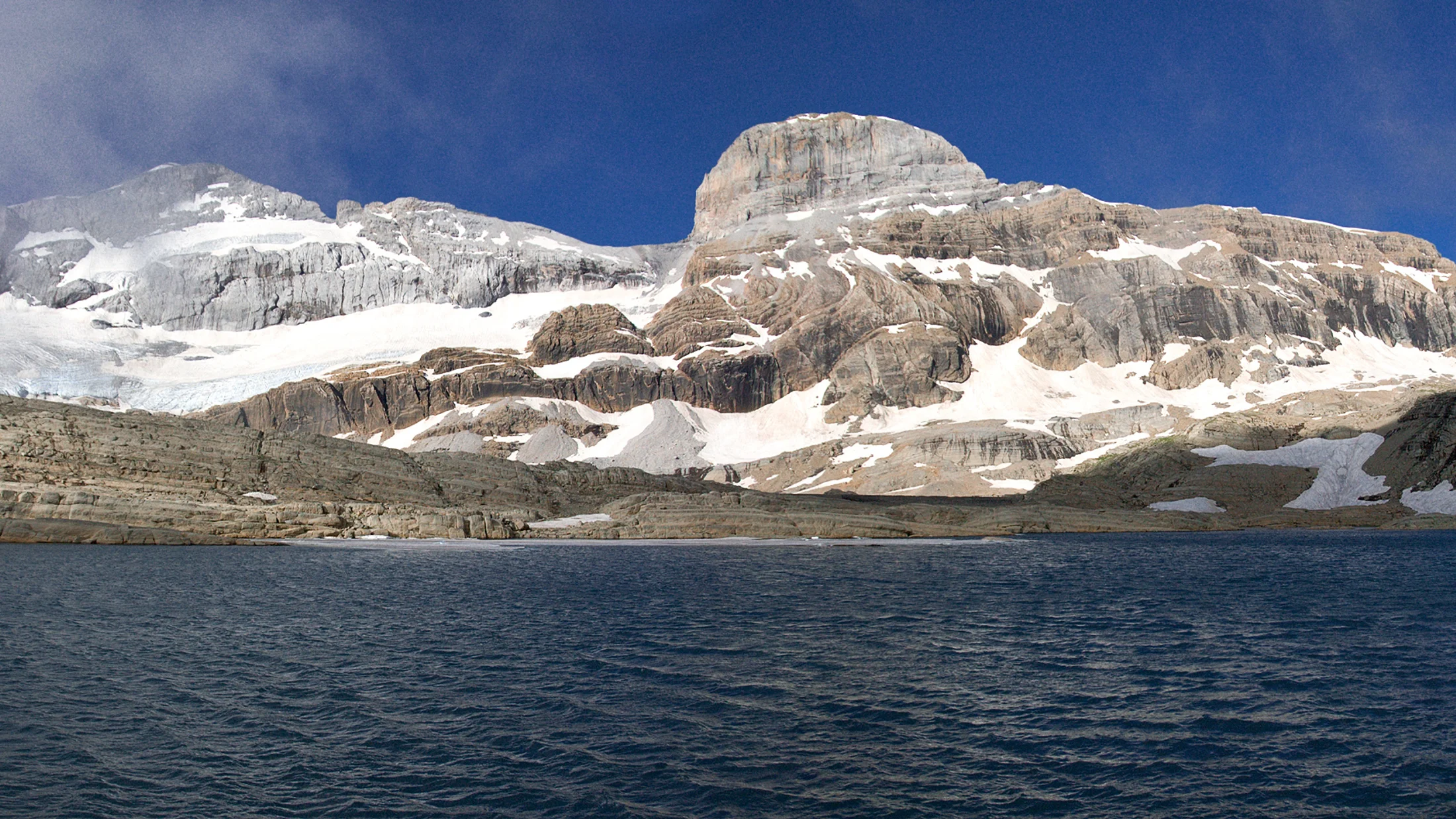
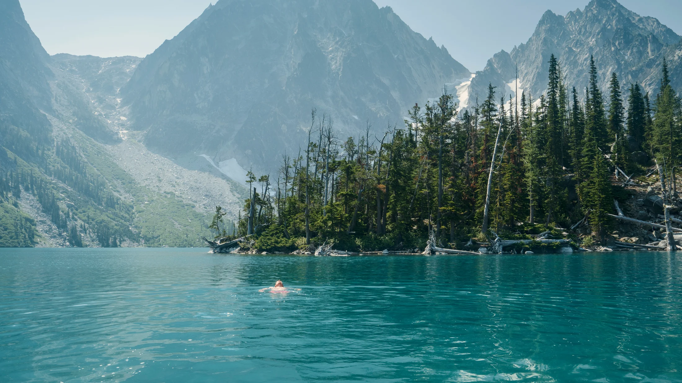
High mountain lakes Spain swim searches point to a very real thrill: clear, cold water ringed by rock and sky. You step into a bowl carved by ice and feel summer fall away with the first sharp breath. In Spain, these are small, clean basins fed by snowmelt, often called ibones in the Pyrenees, where a quick dip can refresh a long hike.
- “High‑mountain” here means basins above roughly 1,500–1,800 m with alpine character: treeline fringes, glacial cirques, and short, cool summers.
- The reward is pristine water and vast panoramas; the risk is cold shock, sudden weather, and occasionally technical access.
- Always check if bathing is legal: some protected areas ban it to protect fragile shorelines and amphibians.
- Use the lake entries like field cards: find the range and municipality, trail time and ascent, best months, who it suits (families, hikers, cold‑water swimmers), and extra things to do.
- You will also find an interactive map description, practical safety tips, a checklist, and concise FAQs to travel smart.
One clean image to hold onto: light flickers on ripples like a handful of coins tossed into blue glass. If you want a quick start, skim the bullet points in each card and save your favorites to your plan.
How we chose these waters
We prioritized altitude and alpine setting, legal clarity, water quality, practical access on foot, safety, and landscape value. We verified regulations through official park pages and signage on site, cross‑checking with local ranger notices and municipal bylaws; where rules are strict (national parks), we say so plainly and offer alternatives. We also leaned on local knowledge—shepherds, refuge wardens, and long‑time guides—to ensure tradition and care travel together. Security and sustainability came first: no fragile shores, no nesting grounds, no trampling meadows for a selfie. Picture a set of blue mirrors cradled by granite, chosen to be swum with respect or admired without harm.
Picuco te puede ayudar
Does something here catch your eye?
Tell us.
Write to us on WhatsApp or email: we answer questions, find the best options and help you sort out the booking.
Top 12 High‑mountain Lakes and Lagoons to Swim in Spain
1.Laguna Grande de Gredos: a cold dip in Gredos’ glacial amphitheatre
Granite walls circle this classic glacial bowl above the PR-AV-17 from the Plataforma de Gredos, and the “Laguna Grande de Gredos swim” has become a rite of passage for mountain lovers. In the thin air, water can feel pin‑bright even at noon. Local wardens ask visitors to avoid soaps and to step lightly on banks.
- Location: Sierra de Gredos, Ávila (Castile and León); access from Plataforma de Gredos car park (Hoyos del Espino).
- Altitude: ~1,950 m.
- Access: Stone‑paved and rocky path via
PR-AV-17; 2–3 h one way, 6–8 km return, +350–450 m. - Fees/reservations: Car park fee in peak months possible; no swim permit required as of latest notices—check Parque Regional Sierra de Gredos for updates.
- Best time: July–September; early autumn on warm days.
- Ideal for: Hikers, photographers, cold‑water dippers.
- Temperature/reality: 8–14 °C typical in summer; short immersions only.
- Do besides: Classic views of Circo de Gredos, ascent toward Almanzor for experts, starry photography from the hut vicinity.
- Notes: No soap, no litter; keep distance from iberian amphibians in shallows; avoid busy boulders if goats are around.
A single shimmer of wind turns the laguna’s dark green to slate in seconds.
2.Lagos de Covadonga (enol and Ercina): within reach, but bathing is off‑limits
Set among rolling meadows and limestone towers in Picos de Europa, Enol and Ercina are emblematic lagunas de montaña Spain bathing travelers dream about—but here swimming is prohibited. Herd bells carry across the water like a soft metronome. Visit for the landscape, not a dip.
- Location: Picos de Europa, Asturias; CO‑4 road from Covadonga (Cangas de Onís).
- Altitude: ~1,070–1,108 m.
- Access: Road access with summer restrictions (shuttle buses operate in peak season); short signed paths around both lakes.
- Fees/reservations: Shuttle bus ticket in restricted periods; bathing prohibited by park regulations (Parque Nacional de los Picos de Europa).
- Best time: May–October for clear trails and wildflowers.
- Ideal for: Families and walkers combining scenic drives and short strolls.
- Do besides: Mirador de Entrelagos, circular walks, cheese tasting in nearby shepherding villages.
- Notes: Respect no‑swim signs; do not enter water or reed beds; pack out all trash.
Light grazes the meadows and limestone like butter on a warm pan.
3.Ibón de Anayet: a mirror for Midi d’ossau
This pair of ibones for bathing—ibón means a Pyrenean glacial lake—sit beneath black Anayet spires with Midi d’Ossau filling the skyline. The water looks like green glass when the wind sleeps. It’s a classic cold‑water stop for mountain lakes for swimming Pyrenees enthusiasts.
- Location: Valle de Tena, Formigal (Huesca, Aragón).
- Altitude: ~2,230 m.
- Access: Trail from Anayet parking (Formigal ski area); 2–2.5 h one way, ~5.5–6.5 km return, +600 m.
- Fees/reservations: None; check seasonal road access to ski car parks.
- Best time: July–September; snow patches can linger.
- Ideal for: Couples, photographers, strong hikers.
- Temperature/reality: 6–12 °C; enter gradually to avoid cold shock.
- Do besides: Trek to Anayet pass, shoot alpenglow on Midi d’Ossau, picnic above the tarns.
- Notes: Avoid fragile shore plants; weather turns quickly—carry layers.
A dragonfly skims the surface and stitches a silver thread across the stillness.
4.Ibones de Bachimaña (superior/inferior): cold basins above Panticosa
Up from the Balneario de Panticosa, stepped dams and natural basins form the Bachimaña chain, a striking example of lagos glaciares baño España in a rugged cirque. Stone and water trade colors with the passing clouds. The refuge offers shelter and an anchor point for longer days.
- Location: Above Balneario de Panticosa, Valle de Tena (Huesca, Aragón).
- Altitude: ~2,200–2,250 m.
- Access: From Balneario de Panticosa parking; 2.5–3.5 h one way, ~7–9 km return, +800–900 m; good path with some rocky steps.
- Fees/reservations: No fee to hike; refuge booking recommended if staying.
- Best time: July–September; cooler but often clear in early autumn.
- Ideal for: Full‑day hikers, photographers, night‑sky watchers.
- Temperature/reality: 5–10 °C; swift entry and exit, keep swims brief.
- Do besides: Push on to Ibón Superior, practice night photography under the Milky Way, visit the historic spa below.
- Notes: Afternoon storms common; leave no trace on granite slabs.
The water holds the color of old bottle glass under a thin mountain breeze.
5.Ibón de Respomuso: alpine waters on the gr-11
At the head of the Aguas Limpias valley, the Respomuso basin and refuge welcome walkers on the trans‑Pyrenean GR-11. The dammed ibón keeps a steady, blue‑black surface even in wind. Swimmers should treat it as a brief immersion zone, not an all‑day beach.
- Location: Sallent de Gállego, Valle de Tena (Huesca, Aragón).
- Altitude: ~2,200 m.
- Access: Trail from La Sarra reservoir parking; 3–4.5 h one way, ~14–18 km return, +800–900 m; good signage.
- Fees/reservations: Parking free/regulated locally; refuge reservation needed if overnighting.
- Best time: July–September; early mornings are calmest.
- Ideal for: Strong day hikers, hut trekkers, cold‑water enthusiasts.
- Temperature/reality: 5–9 °C; beware sudden chills and wind‑whipped chop near the dam.
- Do besides: Continue toward Collado de Tebarray, wildlife spotting at dawn, refuge life.
- Notes: Keep clear of intake structures and steep banks; no soap or detergents—ever.
A gust ruffles the surface and the mountains wrinkle inside their own reflection.
6.Ibón de Estanés: a blue plate on the French border
Rolling pastures and old transhumance paths lead to Estanés, where Aragón meets Béarn and the skyline opens wide. The ibón lies like a polished plate in the grass. Families with a bit of stamina will enjoy the pace and views.
- Location: Western Pyrenees, near Candanchú/Somport (Huesca, Aragón), by the French frontier.
- Altitude: ~1,770 m.
- Access: From Spain via Candanchú/Somport area; 2–3 h one way, ~12–14 km return, +500–600 m; alternative start from Sansanet (France).
- Fees/reservations: None; park in designated areas.
- Best time: June–October; avoid snow patches in early season.
- Ideal for: Families with hiking experience, nature watchers.
- Temperature/reality: 8–14 °C on warm days; still cold—plan for short dips.
- Do besides: Scan for vultures and isards, picnic above the shore, loop variants toward
GR-11connectors. - Notes: You’re in/near Parque Natural de los Valles Occidentales—follow signage if any zones are restricted.
A breeze combs the grass and the lake answers with a single shiver.
7.Ibón de Plan (basa de la Mora): legend and icy clarity
In the Valley of Chistau, this emerald bowl under Cotiella appears at dawn to those who arrive in silence—so says the legend of the Moorish maiden. The water looks like a polished jewel when clouds lift. Tradition and care go together here.
- Location: Valle de Chistau, near Plan/Saravillo (Huesca, Aragón).
- Altitude: ~1,910 m.
- Access: By regulated track to Lavasar parking (check seasonal rules) then 45–60 min on foot, or a long ascent from Saravillo (3–4.5 h, +1,000 m).
- Fees/reservations: Track restrictions may apply; no swim permit as of latest municipal notices—verify locally.
- Best time: Late June–September; dawn is magical and calmer.
- Ideal for: Photographers, folklore fans, patient hikers.
- Temperature/reality: 7–12 °C; stones can be slippery—enter with water shoes.
- Do besides: Observe endemic flora, explore toward Ibonet de Plan, visit Chistau villages sustaining mountain culture.
- Notes: Respect local customs (quiet at sunrise), avoid trampling shore meadows, pack out waste.
A veil of morning mist lifts and the lake glows like green enamel.
8.Laguna de las Yeguas / Laguna de los Pájaros (sierra Nevada): spectacular, but no swimming
High above Granada, Sierra Nevada’s tarns sit in one of Spain’s most protected alpine zones; here, lagos de alta montaña para bañarse is a phrase to treat with care. These waters are fragile, and bathing in the National Park is prohibited. Wind whistles across slate and snowfields like a distant flute.
- Location: Sierra Nevada National Park (Granada), high cirques near Veleta.
- Altitude: ~2,800–3,000 m.
- Access: From Hoya de la Mora/Pradollano via marked high‑mountain trails; 2–4 h one way depending on circuit and fitness.
- Fees/reservations: No bathing allowed by National Park rules; parking and shuttle regulations apply in season.
- Best time: July–September for snow‑free access; late melt can persist.
- Ideal for: Altitude‑acclimatized hikers, landscape photographers, astronomy lovers.
- Do besides: Summit trails, night skies, botany walks with certified guides (book via Picuco).
- Notes: Keep 50+ m from shorelines in sensitive areas; never enter water; check park advisories.
The tarns sit like dark eyes in a crown of pale rock.
9.Estany/“laguna” de la Caldera (aigüestortes i Estany de Sant Maurici area): admire, don’t swim
In the Catalan Pyrenees, Aigüestortes i Estany de Sant Maurici National Park protects hundreds of glacial basins; swimming is prohibited throughout the park. The word “caldera” often names steep, kettle‑like tarns formed by ice. Pine resin scents the air while water runs like a whispered thread.
- Location: High Pyrenees, Alta Ribagorça/Pallars Sobirà (Catalonia); within or adjacent to Aigüestortes i Estany de Sant Maurici NP.
- Altitude: ~2,300–2,600 m depending on the specific basin.
- Access: Authorized trails and boardwalks; 1.5–4 h approaches common from park hubs (Espot/Boí).
- Fees/reservations: Park shuttle buses in season; bathing prohibited by NP regulations; permits required for some activities.
- Best time: July–September; thunderstorms frequent in afternoons.
- Ideal for: Excursionists who prize scenery, photographers, families using shuttles.
- Do besides: Circuit among nearby estanys, wildlife watching, learn local place‑names in Catalan.
- Notes: For a legal dip, use permitted river spots outside the core zone or public pools in valley towns.
Sunlight sketches silver runes where streams lace into the lake.
10.Lago de Sanabria: beaches on the Iberian west’s largest glacial lake
Though not strictly high‑alpine in setting, Sanabria is Spain’s largest glacial lake and a cornerstone for glacial lakes Spain swimming with family comfort. Shallow beaches warm a little under July sun, yet the main bowl remains fresh and clean. Breeze brings the scent of broom and pine down to the shore.
- Location: Parque Natural Lago de Sanabria y Sierras Segundera y de Porto (Zamora, Castile and León).
- Altitude: ~1,000 m.
- Access: Road access to multiple authorized beaches (e.g., Viquiella, Custa Llago); signed parking near shore.
- Fees/reservations: Beach access free; parking may be regulated in summer.
- Best time: June–September; August is warmest for families.
- Ideal for: Families, picnickers, open‑water bathers seeking space.
- Temperature/reality: 16–22 °C on warm spells; cooler in the main basin.
- Do besides: Kayak or SUP with certified operators, hike
PRroutes to viewpoints, camp only in regulated sites. - Notes: Lifeguards in peak season on main beaches; outside zones are wild and colder—exercise caution.
A line of wavelets hisses on the sand like soda poured over stone.
11.Laguna de los Pájaros (guadarrama) and lesser‑known local ibones: how to do it right
Sierra de Guadarrama’s Laguna de los Pájaros is a beloved viewpoint, but like many national and regional park waters, bathing is prohibited; use it as a model for how to approach small, local basins elsewhere. Larks write bright notes over the ridges when the wind settles. The template below keeps your swim both legal and kind to the land.
- Example (Laguna de los Pájaros): Peñalara sector, Madrid/Segovia; 2–3 h from Puerto de Cotos; bathing banned—admire only.
- Generic small ibón elsewhere: Choose outside strict core zones; municipal or natural park rules vary.
- Access: 30–120 min on foot from local trailheads; uneven, often rocky paths.
- Best time: July–September; shoulder months for quiet.
- Ideal for: Those seeking solitude and silence.
- Do besides: Photography, quiet picnics on durable surfaces, birdwatching with a small monocular.
- Notes: Always verify local regulations and water quality with town halls or park offices; avoid fragile bogs and reed beds.
A small tarn catches the sky like a pocket mirror in the heather.
12.Ibón de Piedrafita: a practical, village‑based alpine dip
Close to services yet properly alpine, Ibón de Piedrafita sits below Peña Telera and works well for travelers who want a rural stay plus a short hike. The lake wears a ring of reeds that shine like copper in evening light. Local families walk up for brisk dips on hot days.
- Location: Piedrafita de Jaca, Valle de Tena (Huesca, Aragón).
- Altitude: ~1,610 m.
- Access: From Piedrafita (near the wildlife park), 1–1.5 h one way, ~7–8 km return, +350–450 m; straightforward track and path.
- Fees/reservations: None; respect parking areas in the village.
- Best time: May–October; warmest water in July–August.
- Ideal for: Travelers combining rural lodging and a half‑day hike; families with hiking legs.
- Temperature/reality: 10–16 °C; reeds and soft mud near shore—enter with care.
- Do besides: Stay in local casas rurales, book guided routes to Peña Telera viewpoints via Picuco, visit Biescas markets.
- Notes: Check weather—storms form quickly off the ridge; keep dogs leashed near cattle.
Evening swallows stencil arcs over Telera as the lake darkens to ink.
Interactive Map of All Locations
Before you pack a towel, study the interactive map: each point opens a quick card with the lake’s name, region and municipality, approximate coordinates, approach time and ascent, and a clear note on bathing rules. Filters let you sort by access (road plus short stroll, half‑day hike, full‑day hike), best month (snowmelt to early autumn), difficulty (easy to strenuous), family‑friendly options, and legality (allowed, discouraged, prohibited). For trip‑planning, toggle layers to display GR-11 segments, shuttle bus stops, and seasonal closures flagged by park notices. A waypoint tap reveals parking hints and water temperature ranges where available, plus links to route descriptions and local advisories. Calm blue pins group in the Pyrenees; a few sit south in Sierra Nevada and west in Sanabria, like dew on a folded map. Check the map the day before you go: weather, access, and rules can change with droughts, storms, or wildlife protection measures.
How to Choose a High‑mountain Lake for a Safe Swim
Start with access and altitude, then weigh legality and your cold‑water tolerance. A safe choice matches your time, fitness, and the day’s forecast, not just a photo. Imagine the sequence: a warm hike, a fast, controlled dip, dry layers on, tea from a flask—pins and needles becoming a steady glow in your hands.
-
Access and time
- How long is the approach? Under 60 minutes, 2–3 hours, or more?
- What’s the elevation gain? +300 m is moderate; +800 m demands stamina.
- Path quality: paved slabs, rocky steps, or boulder hopping? Trekking poles help on descents.
-
Legality and environmental sensitivity
- Is bathing explicitly allowed, tolerated, or banned? National parks (e.g., Picos, Aigüestortes, Sierra Nevada) generally prohibit swimming.
- Are there seasonal protections (nesting amphibians, waterfowl, drought)? Signs beat hearsay.
- Shoreline type: bogs and reed beds are off‑limits—enter only on durable rock if bathing is legal.
-
Water safety
- Temperature: under 10 °C is extreme; 10–15 °C is cold; over 16 °C is rare at altitude.
- Know cold shock: enter gradually, control breathing, limit time to a few minutes.
- Avoid dams, intakes, and steep drop‑offs; never swim alone.
-
Logistics
- Parking: regulated mountain car parks fill early; use shuttles when in place.
- Services nearby: refuges, villages with cafés, or none.
- Weather windows: mountain storms build after 14:00—plan to be descending by then.
Quick checklist before you leave:
- Check rules on the official park or municipal page.
- Read the weather and wind forecast for altitude, not just the valley.
- Pack warm layers, a hot drink, and a dry bag.
- Bring water shoes, a small towel, and a changing robe or big T‑shirt.
- Tell someone your plan and return time.
- Carry a trash bag; leave the shore cleaner than you found it.
Practical Tips for Alpine Bathing: Gear, Temperature, and Respect
Pack light but smart: thin neoprene booties and gloves, or a shorty wetsuit if you plan more than a quick dip; grippy water shoes to protect feet on slick stones; a microfibre towel; and a warm hat for after. One clean sensory note to remember: the first sip of hot tea after the water feels like sun returning to your bones.
-
Preventing hypothermia
- Limit immersion to 1–3 minutes at 8–12 °C; warm up, then consider a second short dip.
- Enter slowly; exhale steadily to blunt cold shock.
- Change immediately into dry, windproof layers; move to generate heat.
-
Safety for children and pets
- Choose warmer, lower lakes (e.g., authorized beaches at Sanabria); keep kids in the shallows with adult arms’ reach at all times.
- Dogs disturb wildlife—leash them and do not let them enter protected waters.
-
Leave No Trace basics
- Stay on durable surfaces; avoid trampling shore plants and moss.
- Pack out all trash, including organic waste; never wash dishes, bodies, or clothing in lakes.
- Use restroom facilities where available; otherwise, bury human waste 60–70 m from water and pack out paper.
-
Photography without harm
- Shoot from rock or trail, not on reed beds or bog mats.
- Drones are often banned in protected areas—check rules before launching.
- Golden hours are best; avoid crowding small shores for a shot.
-
Hygiene and water quality
- No sunscreen reapplication just before entry—choose mineral formulas and apply long before swimming.
- Do not enter if you have open wounds or recent illness; it’s safer for you and the lake.
- After droughts or heavy storms, check local advisories for water quality.
Frequently Asked Questions
A brief hush falls on most shores, and with it come the same sensible questions—here are direct, safety‑first answers.
Do I need a permit to swim?
Usually no, but many protected lakes ban bathing outright (national parks and some natural parks). Always check official park or municipal regulations; signs on site are decisive.
How do I avoid hypothermia?
Enter gradually, exhale to stabilize breathing, and keep the first dip under 1–3 minutes in 8–12 °C water. Dry off, dress warm, sip something hot, and move; stop if you shiver hard or feel dizzy.
What should I do if I get a cramp in the water?
Stay calm, roll onto your back, and float; massage or stretch the affected muscle gently while you kick to shore. Get warm and rehydrate—electrolytes help.
Are there zones where swimming is prohibited?
Yes: in general, lakes within Aigüestortes, Sierra Nevada, and Picos de Europa national parks are no‑swim. Some reservoirs and dam intakes are also off‑limits; obey all signage.
When is the water too cold?
Below 10 °C is extreme—only short, controlled immersions for experienced cold‑water swimmers. Many alpine lakes sit at 6–12 °C even in summer; plan brief dips, not long swims.
How can I check water quality?
Look for municipal or park advisories posted online or at trailheads. Avoid water after heavy storms, during algal blooms, or if livestock are crowding the shore; choose clear inflow points on rock.
Is it safe for children?
Prefer legal, monitored beaches (e.g., Lago de Sanabria) and keep children in warmer, shallow areas. At altitude, cold shock is real—skip the dip for kids if water feels biting within seconds.
Can I use soap or biodegradable products?
No. Even “biodegradable” soaps harm alpine waters. Wash well away from lakes and streams if you must, and pack out wipes.
Book your experience — discover active tourism activities in Spain with providers verified by Picuco.
Plan Your Mountain Swim with Care
Choose a lake with honest eyes: match your route, the rules, and the day’s weather, and your dip will feel like a small, bright victory. A quick review of our map, the lake cards, and the checklist will help you thread scenery, safety, and respect into one plan. Before you go, confirm bathing permissions, shuttle schedules, and any drought or wildlife advisories through official park pages or local town halls. When you return, share your notes with the community and help keep these waters clean by passing on good habits. If you want fresh ideas for guided hikes, cold‑water introductions, or family‑friendly outings, explore options on Picuco and build a weekend that fits your pace.