Why Active Tourism in the Canary Islands Belongs on Your List
You come to the Canary Islands for movement: wind in the sails, feet on lava, and salt on skin. Here, active tourism in the Canary Islands blends hiking, surfing and encounters with volcanic nature into one compact archipelago you can visit year-round. In this article, you’ll find seven island entries with concrete routes, standout surf spots, difficulty levels, seasons, logistics, and sustainability tips to plan your own trip.
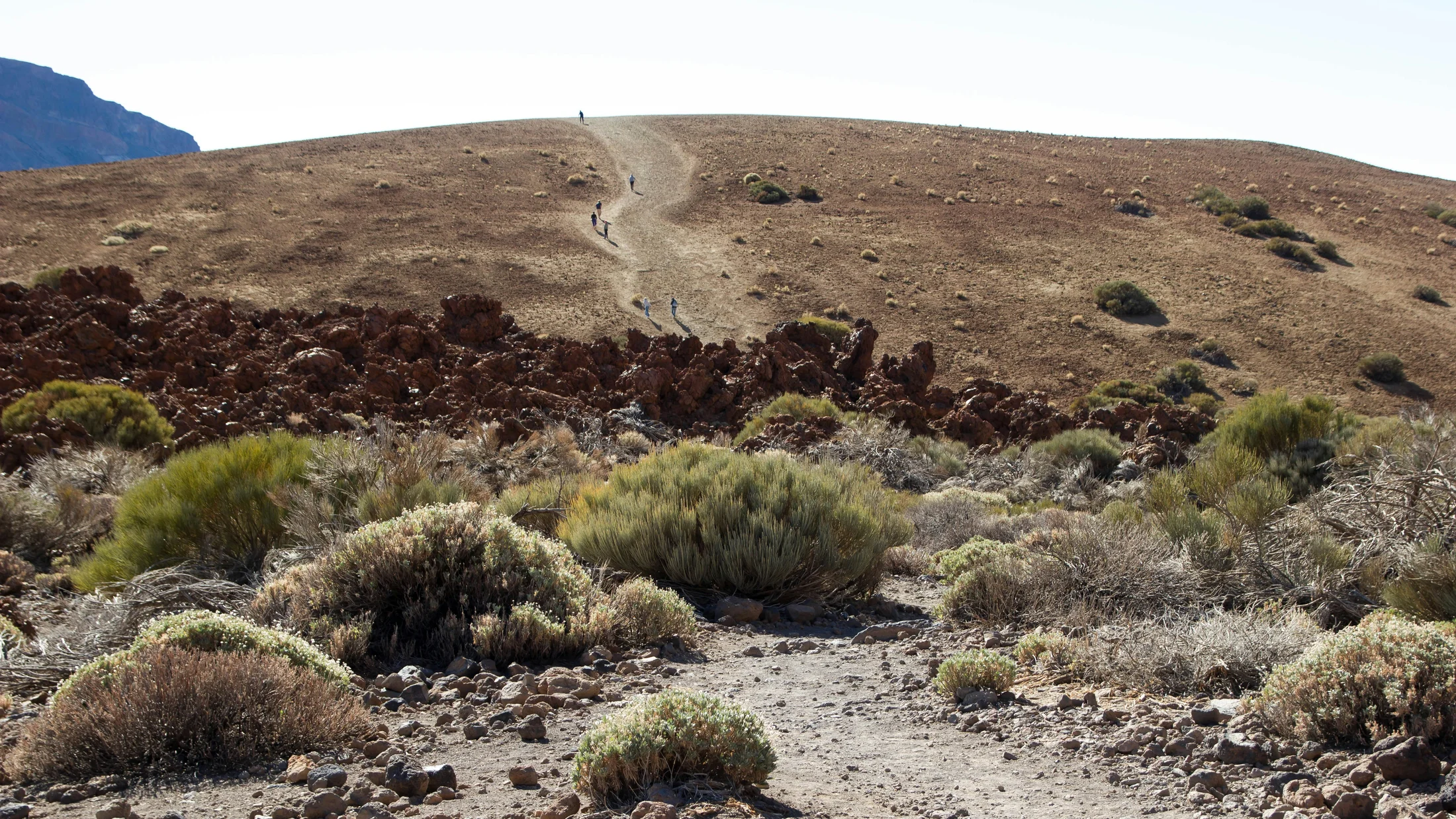
A living landscape for outdoor travelers
The archipelago rises from the Atlantic as a chain of volcanoes shaped by time, wind and currents. You can hike high-altitude trails on Teide, wind through laurel forests, and cross fossilized lava fields within a few days—this is why turismo activo Canarias keeps drawing hikers and surfers back. Swells arrive mostly from the northwest in autumn–winter, while the NE trade winds favor kitesurf and windsurf from spring to early autumn. One moment the air is cool at 2,000 m; an hour later you’re barefoot on warm black sand. Expect microclimates, dramatic gradients, and nature that still feels wild.
- Landscapes: stratovolcanoes, calderas, malpaís (rough lava), laurisilva (ancient laurel forest), dunes and cliffs
- Activities: hiking, trail running, surfing, bodyboarding, snorkeling, diving, birdwatching, stargazing
- Safety: strong UV, variable winds, rip currents; stick to marked trails and local advice
- Conservation: national parks and reserves enforce rules—no off-trail shortcuts, no rock stacks, pack out all waste
For verifiable context: Teide National Park is UNESCO World Heritage (UNESCO, 2007), Garajonay National Park protects primeval laurel forest (UNESCO, 1986), and Timanfaya National Park conserves historic lava fields (Government of Spain, 1974). The volcanic nature in the Canary Islands remains the main stage for this experience.
A single breath smells of warm pine resin and faint sea salt riding the trade winds.
How we chose and how to read this guide
We selected all seven islands because each one offers a distinct blend of hiking, surf potential, and volcanic nature with reliable access and services. Every island entry includes: where it shines, flagship hikes with distance and difficulty, best surf beaches or reefs with seasons, basic costs (rentals, permits), and how to get around. We flag when you need permits, reservations, or guides and add simple sustainability notes. Read it as a planning toolkit: pick your season, match your fitness and interests, and then layer logistics like ferries, car rentals, buses, and rural stays.
Think of this guide like a topo map: concise symbols first, clear lines to follow next.
Picuco te puede ayudar
Does something here catch your eye?
Tell us.
Write to us on WhatsApp or email: we answer questions, find the best options and help you sort out the booking.
The Seven Islands for Outdoor Adventure, One by One
1) Tenerife: hiking Teide and surfing El Médano
Tenerife balances high-altitude hiking with consistent wind and friendly surf towns. Teide (3,715 m), Spain’s highest peak, anchors the island with trails above the clouds and a summit that requires a free permit for the final Telesforo Bravo section. Mornings can be icy at altitude while afternoons glow warm on the coast.
- Signature hikes (Teide National Park):
- Montaña Blanca to Refugio de Altavista (up to 3,260 m): 8–9 h round trip, high difficulty, altitude acclimatization advised
- Roques de García loop: ~4 km, 1.5–2 h, easy–moderate, classic lava towers and views
- Pico Viejo viewpoint from
TF-21pullout: 3–4 h, moderate, vast crater vistas - Teide summit: requires free permit (limited daily quotas; request well in advance on the park’s official system), or cable car + short ascent within permit window
- Surf: El Médano (Playa Sur for learners, El Cabezo for advanced with strong NE wind), best Apr–Sep for wind-driven sessions; north coast reefs (Bajamar/Punta del Hidalgo) get powerful winter swells for experienced surfers
- When to go: hiking year-round, best clear skies Nov–May; surf swells peak Oct–Mar (north), wind and kitesurf peak Apr–Sep (south)
- Logistics and costs: Tenerife South (TFS) and North (TFN) airports, buses (
TITSA) connect main towns; cable car tickets and summit permits vary—check official sites; surf board rental ~per-day rates vary by town; confirm with local operators - Sustainability and safety: bring layers for 0–25°C swings, 2–3 L water per person at altitude, sunscreen; stay on marked trails in fragile lava fields
From the Cañadas, the Teide shadow slides over pumice slopes like a slow tide.
2) Gran Canaria: summit routes and beaches for surfers
Gran Canaria is a miniature continent: pine forests in the center, dunes and surf on the coasts, and old volcanic plugs pointing the way. You move from cool summit ridges to warm southern beaches in under 90 minutes.
- Summit hikes:
- Roque Nublo loop: ~5 km, 1.5–2 h, easy–moderate, iconic monolith and expansive views
- Pico de las Nieves approach: multiple short viewpoints around the island’s highest point (1,949 m), easy access by road with brief paths
- Cruz de Tejeda ridge paths and
GC-150viewpoints: pick 2–10 km sections, moderate, cooler temperatures
- Surf:
- Las Canteras/El Confital (Las Palmas): advanced reef waves in winter swells (Oct–Mar); beach peaks for intermediates
- Pozo Izquierdo (SE coast): world-class wind for windsurf/kite, best Apr–Aug; surfable wind swells are choppy—advanced skills
- When to go: hiking Oct–May for clear, cool conditions; surf Oct–Mar (reefs and beach breaks); kiting/windsurf Apr–Aug
- Logistics and costs: Gran Canaria Airport (LPA), robust bus network (
Guaguas Global) to major towns; car hire common for interior; board rentals and lessons available in Las Palmas and south resorts—confirm prices with local schools - Sustainability and safety: respect agricultural terraces and
casa cuevaheritage in mountain villages, avoid off-trail shortcuts to prevent erosion; check rip current flags on urban beaches
Pine resin mingles with coffee aromas in hill towns where hikers trade stories at dusk.
3) Lanzarote: volcanic landscapes and North coast waves
Lanzarote is an open-air geology class: dark malpaís textures, hornitos (small vents), and vineyards trained in volcanic hollows at La Geria. The horizon often hums with Atlantic haze, and the ground keeps a day’s worth of warmth after sunset.
- Volcanic nature:
- Timanfaya National Park: guided routes on regulated roads and short walks; respect strict stay-in-vehicle rules in core zones
- La Geria: easy walking among stone windbreaks protecting vines; combine with tastings if you’re not driving
- Caldera Blanca: 9–11 km, 3–4 h, moderate, rim walk with panoramic lava seas
- Surf (north and northwest):
- Famara Beach: long sandy bay with peaks for beginners–intermediates; best with mid–high tide and NW swells (Oct–Mar)
- La Santa and surrounding reefs: advanced-only, powerful, shallow lava bottoms
- Charcos (tidal pools) near Orzola and Punta Mujeres: safe for post-surf swims at calm tides
- When to go: hiking and cycling year-round; surf strongest Oct–Mar; winds steady most months, lighter in winter
- Logistics and costs: Arrecife Airport (ACE); car rental is efficient; board rentals and lessons in Famara; snorkeling gear rental available—confirm prices locally
- Sustainability and safety: carry 2 L water per person; high UV; watch for sharp lava and sensitive lichens; follow reserve signage in Jameos/La Corona areas
As trade winds brush Famara cliffs, salt spray hangs in the air like fine mist.
4) Fuerteventura: longboards, beaches and volcanic trails
Fuerteventura offers kilometer-long beaches, gentle rollers for longboarders, and desert-like volcanic plateaus for easy-to-moderate hikes and runs. Light shifts make the dunes glow butter-yellow at sunrise and ember-orange at sunset.
- Surf and wind:
- Corralejo/Flag Beach: learner-friendly inside sections; outer reefs for intermediates; best Oct–Mar for groundswells
- El Cotillo: beach peaks and nearby reefs, consistent winter surf
- Sotavento (Costa Calma): world-renowned for wind/kite with NE trades Apr–Sep; lagoon sessions at mid–high tides
- Hiking and trails:
- Calderón Hondo: ~5 km, 1.5–2 h, easy, crater rim views
- Corralejo Dunes Natural Park: beach walks 2–8 km, easy; stay off sensitive dune vegetation
- Coastal paths around Ajuy and La Pared: short clifftop sections, respect edge setbacks
- When to go: surf Oct–Mar; kite/wind Apr–Sep; hiking year-round with early starts in summer
- Logistics and costs: Fuerteventura Airport (FUE); frequent ferries to Lanzarote (Órzola/Playa Blanca) and Gran Canaria; rentals for boards and kites common—confirm rates with operators; protect car interiors from sand
- Sustainability and safety: avoid trampling dune grasses, keep distance from nesting birds, bring 2 L water and wind layers; mind strong currents on west-facing beaches
Warm wind whistles over dune crests like a soft flute, then falls to hush in leeward hollows.
5) La Palma: forests, recent volcanism and trekking
La Palma—La Isla Bonita—combines laurel forests, steep barrancos, and very recent volcanic terrain. Paths smell of wet leaf litter after trade-wind showers, and starry nights feel close enough to touch.
- Trekking highlights:
- Caldera de Taburiente National Park: routes from Los Brecitos down the ravine network, 6–16 km depending on variations, moderate; river crossings, shade, birdlife
- Ruta de los Volcanes (section of
GR-131): ~19–24 km between El Pilar and Fuencaliente, 6–8 h, demanding for elevation changes and loose ash - Volcanoes of 2021 (Cumbre Vieja area): access and trails evolve; guided visits and marked viewpoints change with safety assessments—check current restrictions
- When to go: Oct–May for cooler hiking; summer is possible with early starts; occasional closures after heavy rain or due to volcanic risk
- Logistics and costs: La Palma Airport (SPC); buses connect main towns but a car helps for point-to-point trails; guides recommended for off-path lava edges and new terrain; gear rentals (poles, helmets) available—confirm locally
- Sustainability and safety: ash terrain is fragile; stay on signed paths; carry 2–3 L water, headlamp for early starts, and respect ongoing recovery efforts in affected communities
In laurel shade, moisture beads on ferns while distant surf thumps softly below the cliffs.
6) La Gomera: ancestral paths and protected nature
La Gomera’s ancient caminos stitch together hamlets and terraces, with Garajonay’s laurel forest breathing cool and damp under cloud caps. The island is quieter, with long contours and short ferry hops from Tenerife.
- Classic routes:
GR-132Coastal Circuit: multi-day, sections 8–18 km each, moderate–demanding due to steep ascents/descents and heat- Garajonay short loops: 2–7 km, easy–moderate, mossy trunks and endemic birds
- Valle Gran Rey terraces: stair-stepped paths dropping to the sea, 4–10 km options, moderate
- Water and wildlife:
- Dolphin and whale watching departures from Valle Gran Rey/San Sebastián (seasonal); snorkeling in calm coves on leeward coasts
- When to go: Oct–May for hiking comfort; summer routes possible with dawn starts
- Logistics and costs: ferries from Tenerife (Los Cristianos) to San Sebastián (50–70 min fast ferries, longer for conventional); rural stays and small guesthouses are common; local guides enrich history and ensure safe navigation
- Sustainability and safety: protect terrace walls and footpaths, avoid loud noises in Garajonay, carry layers for rapid cloud/rain
Mist drifts between laurel branches, and footsteps land softly on springy leaf litter.
7) El Hierro: remote trails, diving and emerging volcanism
El Hierro is the quietest of the big seven: fewer roads, dark lava shelves, and waters protected since the 1990s. Silence here is part of the itinerary, interrupted only by wind and swells.
- Hiking and viewpoints:
GR-131ridge segments: 10–20 km day stages, moderate–demanding, sweeping views from juniper groves to lava shelves- Mirador de La Peña to Las Puntas variants: 6–10 km, moderate, cliff-edge panoramas
- El Sabinar twisted junipers: short, easy strolls with iconic wind-shaped trees
- Diving and sea:
- La Restinga–Mar de Las Calmas Marine Reserve: clear waters, volcanic bottoms; best Sep–Nov for visibility and calm seas; guided dives for all levels
- Submarine volcanism (2011–12 area south of La Restinga): boat tours and interpretation, access subject to current regulations
- When to go: hiking Oct–May; diving year-round with peaks in late summer–autumn; bird migration in shoulder seasons
- Logistics and costs: small airport (VDE) via Tenerife/Gran Canaria; limited buses—car rental recommended; services cluster in Valverde/La Restinga; book accommodation early in high season
- Sustainability and safety: carry cash for remote villages, pack extra water/food on ridge hikes, avoid cliff edges in wind; respect fishing restrictions in reserves
At dusk, the ocean turns ink-blue and the lava coast holds the day’s warmth like a quiet hearth.
Map of Key Locations
A good map makes the islands feel closer—just symbols, colors and the Atlantic breathing between them. For an interactive viewer, place markers for each island’s key hikes, surf zones and parks, and add layers that toggle by difficulty, season and access.
- Markers per island:
- Tenerife: Teide trailheads (Montaña Blanca, Roques de García), El Médano (Playa Sur, El Cabezo)
- Gran Canaria: Roque Nublo, Pico de las Nieves viewpoints, Las Canteras/El Confital
- Lanzarote: Timanfaya visitor areas, Caldera Blanca start, Famara beach peaks
- Fuerteventura: Calderón Hondo, Corralejo Dunes entries, El Cotillo, Sotavento lagoon
- La Palma: Los Brecitos/Caldera entries,
GR-131sections, official volcano viewpoints - La Gomera:
GR-132access points, Garajonay parking areas, Valle Gran Rey coves - El Hierro:
GR-131ridge trailheads, El Sabinar, La Restinga dive centers
- Suggested layers:
- Difficulty: color scale (green easy, blue moderate, red demanding)
- Season: icons for swell (Oct–Mar) and trades (Apr–Sep); snowflake icon for occasional high-altitude cold
- Access: car, bus, ferry icons; parking notes and reservation flags
- Technical tips:
- Use vector tiles for smooth zoom; satellite basemap toggle for lava detail
- Include a legend and a scale bar;
EPSG:4326coordinates shown on hover - Provide short pop-up text: 1–2 lines per marker with distance, time, and “permit required” where relevant
With one glance, you’ll see swells on the north coasts and summits stitched by high trails.
How to Choose Your Island and Activity
Start with your season and energy, then match island personality to your goals. If you want altitude and classic hiking, choose Tenerife; for a one-base surf city with mountain day trips, Gran Canaria fits; for raw lava and long beach runs, think Lanzarote or Fuerteventura. The air can change quickly: plan layers, hydration, and flexible days.
-
Quick checklist:
- Fitness level: Can you handle 800–1,200 m elevation gain, or prefer 2–8 km loops?
- Primary interest: surf vs. hiking vs. volcanic geology vs. diving/snorkel
- Season: Oct–Mar (north swells, cooler hiking); Apr–Sep (trade winds for kite/wind, warmer seas)
- Logistics: car hire vs. buses/ferries; single-island base vs. multi-island hop
- Accommodation: rural house near trailheads vs. coastal town with surf schools
- Permits/reservations: Teide summit, Masca Gorge bookings, guided dives
-
Fast comparison by vibe and timing:
| Island | Signature terrain | Standout hikes | Surf character | Best months |
|---|---|---|---|---|
| Tenerife | High volcano, pine forests | Montaña Blanca, Roques de García, Teide summit (permit) | El Médano wind Apr–Sep; north reefs Oct–Mar | Year-round; clearer Nov–May |
| Gran Canaria | Central highlands, dunes | Roque Nublo, summit viewpoints | City reefs and beach breaks, Oct–Mar | Hiking Oct–May |
| Lanzarote | Lava seas, vineyards | Caldera Blanca, Timanfaya areas | Famara for all levels, reefs for experts | Surf Oct–Mar |
| Fuerteventura | Dunes, desert volcanoes | Calderón Hondo, coastal walks | Longboard-friendly beaches; strong trades Apr–Sep | Year-round; wind Apr–Sep |
| La Palma | Steep barrancos, new lava | Caldera de Taburiente, GR-131 Ruta de los Volcanes |
Limited; focus on trekking | Oct–May |
| La Gomera | Laurel forest, terraces | Garajonay loops, GR-132 sections |
Calm coves; focus on hiking/nature | Oct–May |
| El Hierro | Cliffs, marine reserve | GR-131 ridge, El Sabinar |
Diving hotspot; limited surf | Hiking Oct–May, diving Sep–Nov |
- Combining activities in one stay:
- Tenerife south: morning kitesurf at El Médano, next-day Teide sunrise hike
- Gran Canaria: city surf at Las Canteras + Roque Nublo loop by car
- Lanzarote–Fuerteventura: short ferry, split a week between Famara surf and Corralejo dunes hikes
- La Palma–El Hierro: two-island trekking and diving combo, with recovery days in coastal villages
If you feel the pull of ocean and ridge in the same day, you’re choosing well.
Frequently Asked Questions
A crashing break can sound fierce, but good decisions and simple rules make days smooth.
Are the hiking trails well marked and safe?
Most classic routes are signed and maintained, especially in national parks and senderos homologados (GR/PR). Stay on paths, check weather at altitude, and carry a map or offline app; fog and wind can reduce visibility quickly.
Do I need permits for Teide or other hikes?
Yes for the Teide summit’s final Telesforo Bravo section (free, limited daily quotas). Some routes like Masca Gorge require advance booking and specific safety gear; always verify current rules on official channels before you go.
When is the best time to surf in the Canary Islands?
Northwest swells peak Oct–Mar for powerful reef and beach breaks. Apr–Sep brings stronger NE trade winds, favoring kitesurf and windsurf in spots like El Médano or Sotavento. Always assess rip currents and reef hazards on arrival.
Can beginners learn to surf here?
Yes, on sandy bays like Famara (Lanzarote), Las Canteras sections (Gran Canaria), or protected corners near Corralejo (Fuerteventura). Choose certified instructors, start on soft tops, and avoid shallow reefs until you’re comfortable.
How do I move between islands?
Short flights connect all islands daily, and ferries link neighboring pairs (e.g., Tenerife–La Gomera, Lanzarote–Fuerteventura). Factor weather: winds can delay crossings; keep buffers if you have tight connections.
What gear should I pack for mixed hiking and surf?
- Hiking: breathable layers, wind shell, trail shoes with grip, 2–3 L hydration, sun hat, headlamp
- Surf: 3/2 mm wetsuit in winter (water ~18–20°C), rashguard and reef booties for lava entries, soft top for learners
- Extras: reef-safe sunscreen, small first-aid kit, dry bag for ferries
How do I book guides or lessons?
Book certified guides for technical terrain or new lava areas, and verified schools for surf and dive. In high season (Dec–Mar; Jun–Sep for wind), reserve at least a week ahead; shoulder seasons are more flexible.
What are the rules in protected areas?
Follow marked routes, do not remove rocks or plants, keep noise low, and avoid drones without permits. In dunes and laurisilva, stepping off trails damages fragile soils and roots.
Is tap water drinkable?
In major towns yes, but taste varies and some rural areas rely on desalination. Carry and refill from safe points; always bring extra on ridge hikes or desert-like routes.
Book your experience — discover active tourism across Spain with trusted, verified providers on Picuco.
Conclusion
Seven islands, one pulse: ridgelines, reefs and lava fields made for motion. Whether you aim for Teide’s thin air, a long left in winter, or the hush of Garajonay’s laurisilva, the Canary Islands make active travel simple with short distances, reliable weather and communities that know these landscapes by heart. Choose your season, match routes and waves to your level, and plan with respect for trails, coasts and local livelihoods.
Anchor safety and sustainability in every choice: carry water, wear layers, read ocean flags, and stay on marked paths. For multi-activity trips, build in rest days, use public transport where it works, and support rural accommodations and certified guides who care for the terrain. Now pick an island that fits your time and energy—and let wind, rock and water set the rhythm of your days.