Why Hiking in La Rioja Brings Vineyards, Gorges and Mountains Together
Hiking La Rioja rewards you with a rare trio: vineyards, river gorges and high sierras in one compact region. You walk through a living wine landscape while accessing rugged canyons and forested ridges that define active tourism La Rioja. Think of it as wine region hiking Spain with a wilder edge. The smell of fermenting must and thyme can share the same breeze.
La Rioja’s patchwork of Rioja Alta vineyards, the dramatic Hoces of the Leza and Jubera valleys, and the beech and pine of the Sierra de la Demanda set the scene. Towns like Haro, Briones and San Vicente de la Sonsierra anchor La Rioja vineyards hike options with heritage and river views. At the same time, the Biosphere Reserve of the Leza, Jubera, Cidacos and Alhama valleys protects sharp limestone gorges in La Rioja where griffon vultures spiral. Footpaths are well established, with local trails and longer options that let you combine Rioja hiking trails with winery visits, local cuisine and village stays. Light filters through vine rows like an openwork curtain.
This selection focuses on routes that balance active tourism La Rioja with enotourism value. We looked for three things: vineyard character, canyon drama and mountain feel. The crunch of gravel on vineyard tracks accompanies your steps.
How we chose these seven routes
We chose seven routes based on objective criteria: clear access, strong scenic or geological interest, vineyard or winery connection, safety and seasonal suitability. We cover varied difficulty levels and durations to fit families, couples and groups. Sun warms old stone walls as you scan the skyline.
Read each route as a mini profile: where it is, distance/time, difficulty, highlights (viewpoints, gorges, monasteries, bodegas), best time and logistics such as signage, parking and any costs. Use it to match your time and fitness with the right landscape, and to plan tastings or rural stays around your walk. The cadence of your planning should feel as easy as a gentle country lane.
Picuco te puede ayudar
Does something here catch your eye?
Tell us.
Write to us on WhatsApp or email: we answer questions, find the best options and help you sort out the booking.
Top Rioja Hiking Trails Among Vineyards, Gorges and Peaks
1) Rioja Alta Vineyard Path: A Balcony Over the Vines
Start in Haro, Briones or San Vicente de la Sonsierra and trace vineyard tracks that fold around Ebro meanders for 8–12 km, 2.5–4 hours, mostly easy. This classic La Rioja vineyards hike weaves clay-limestone slopes planted with Tempranillo and Graciano, with low stone walls, “guardaviñas” huts and river terraces. Sunlight flashes on bottle-green leaves like small mirrors.
- Difficulty: Easy to moderate (gentle climbs of 150–250 m).
- Highlights: Haro’s station district heritage, Briones’ hilltop silhouette, the Ebro cliffs near San Vicente, castle ruins and Romanesque hermitages such as Santa María de la Piscina (12th century).
- Best time: April–June for wildflowers; late September–October for harvest colors and activity; winter for crisp skies and low crowds.
- Signage: Local waymarks on farm lanes; carry a basic map or GPX as many tracks interlace.
- Winery connection: Multiple estates offer tastings and visits; tastings often cost 8–20 € per person for standard flights—confirm current options and schedules in advance.
- Logistics: Free access; park on signed public areas in town, not on vineyard margins. Buses and regional trains connect Logroño and Haro, and buses reach Briones and San Vicente (check current timetables).
Practical tip: Start and end in the same town to pair the walk with a late-morning tasting or an afternoon visit, allowing a relaxed pace. Gravel dust and the faint scent of fennel follow your boots.
2) Hoces del Río Leza: Walking the Leza Canyon
The Leza canyon cuts a limestone trench between Leza de Río Leza and Soto en Cameros, with a footpath along its middle and upper edges. Expect 10–12 km one way (3–4.5 hours), or a chosen out-and-back for 2–3 hours, with narrow shelf-path sections that require sure footing. The wind hums along vertical walls as vultures trace slow circles.
- Difficulty: Moderate, with exposure where the path narrows; not suitable for severe vertigo. Elevation gain 300–450 m depending on your start point.
- Highlights: Balcony viewpoints near Trevijano and Soto, folded strata and natural arches, vulture and chough colonies and spring orchids on the slopes.
- Best time: March–June and September–November for mild temperatures. Summer afternoons get hot and shade is scarce; winter can ice up shaded ledges.
- Safety: Keep distance from cliff edges, especially in wet or windy weather. Children need close supervision on narrow traverses.
- Access: Trailheads near Leza de Río Leza and Soto en Cameros with roadside parking; both towns sit inside the Biosphere Reserve of the Leza, Jubera, Cidacos and Alhama valleys.
- Connections: Short detours to village squares with fountains and bars; drivers can stage cars at both ends to walk one-way.
Route note: The canyon path is well trodden but not always consistently waymarked—carry a map or a GPX file and respect any temporary closures for nesting. Sun-warmed rock smells faintly of dust and sage.
3) Monastery of Valvanera Trail: History in a Forested Bowl
The Monastery of Valvanera lies in a green cirque in the foothills of the Sierra de la Demanda near Anguiano, ringed by oak and beech. Choose a classic 8–10 km circular from the monastery (2.5–3.5 hours, 300–400 m ascent) or a longer approach from Anguiano or the Valvanera road. Dappled light pools on mossy trunks like spilled coins.
- Difficulty: Moderate; steady forest climbs on good paths with occasional stony stretches.
- Highlights: The monastery’s Romanesque and later buildings, the venerated image of the Virgin of Valvanera (patron of La Rioja), mountain streams, autumn leaf color and spring birdsong.
- Best time: Spring and autumn for color and comfortable temperatures; summer mornings for shade; winter may bring snow patches at higher points.
- Activities: Visit the monastery basilica, quiet cloisters and small exhibits; pair with local food in Anguiano (noted for “caparrones” beans and traditional desserts).
- Wine link: Although the setting is mountain, you can base in Rioja Alta towns (Haro, Briones, Nájera) and plan tastings before or after a forest day.
- Logistics: Access road to the monastery has signed parking. Entry to the church is typically free or donation-based; check current visiting hours on official sources. Cell coverage is variable; download maps.
Local tip: Combine this route with an overnight in Ezcaray or Anguiano to explore more Demanda foothill walks the next morning. The cool scent of leaf litter follows you back to the abbey square.
4) Sonsierra Ridge and Ebro Viewpoints: Wide Skies Over Vines
The Sonsierra, north of the Ebro in Rioja Alta, offers balcony views that unite vineyard mosaics with river bends and distant Demanda summits. A 12–16 km loop (4–5.5 hours; 350–500 m ascent) from San Vicente de la Sonsierra or Abalos links the castle crest, hermitages and vine tracks to striking overlooks. Patches of light move across rows of vines like a slow tide.
- Difficulty: Moderate with rolling ups and downs; terrain is mostly farm tracks and footpaths.
- Highlights: Castle and medieval bridge at San Vicente, Romanesque hermitages on isolated knolls, the famed “guardaviñas” stone huts and long panoramas toward Haro and Briones.
- Best time: Year-round, but spring and autumn provide soft light for photography; harvest weeks add energy (and farm traffic—take extra care on shared tracks).
- Activities: This is a photographer’s route; plan timed stops at high points and carry a picnic for a midday pause by a dry-stone wall.
- Wine link: Multiple wineries in nearby towns; plan one tasting post-hike to avoid hiking in midday heat, or arrange a late-afternoon visit.
- Logistics: Park in designated areas in San Vicente or Abalos; signage varies across municipal trails. Carry sun protection and 1.5–2 liters of water per person in warmer months.
Pro tip: Start early from the castle ridge to watch light fill the valley, then drop to vine lanes when the day warms. The Ebro glints like a ribbon of steel beyond the terraces.
5) Badén Ravine and Neighboring Canyons: Rock Corridors and Scrambles
The Barranco de Badén, within the Cameros area of central La Rioja, narrows into sculpted channels and short steps, offering a more adventurous outing in dry conditions. Expect 7–10 km (3–4 hours) on mixed terrain: streambed, goat paths and rocky ledges, with optional short scrambles. The echo of your footsteps bounces between honeyed stone walls.
- Difficulty: Moderate to challenging depending on chosen variant; short hands-on moves, loose gravel and occasional exposure. Avoid after heavy rain or during snowmelt.
- Highlights: Water-carved chutes, pockets of riparian vegetation, birds of prey overhead and hidden side ravines with shaded pools in spring.
- Best time: April–June and September–October; midsummer heat can be intense in the gullies, and winter ice makes slabs treacherous.
- Safety: Helmets are optional but wise in narrow sections for rockfall; sturdy grippy boots are essential. Respect any signs prohibiting access during bird nesting or after storms.
- Logistics: Trailheads near Cameros villages (e.g., access from minor roads and farm tracks) with limited parking—do not block farm gates. Routes are minimally marked; take a GPS track and tell someone your plan.
- Combine: Pair with a gentler afternoon stroll along the Leza or Jubera valleys, or with a visit to a village center for a simple menu del día.
Ethic: In ravines, move quietly and yield to wildlife; your reward is often a sudden wingbeat or the rustle of a fox slipping into shade. The stone is warm to the touch by midday.
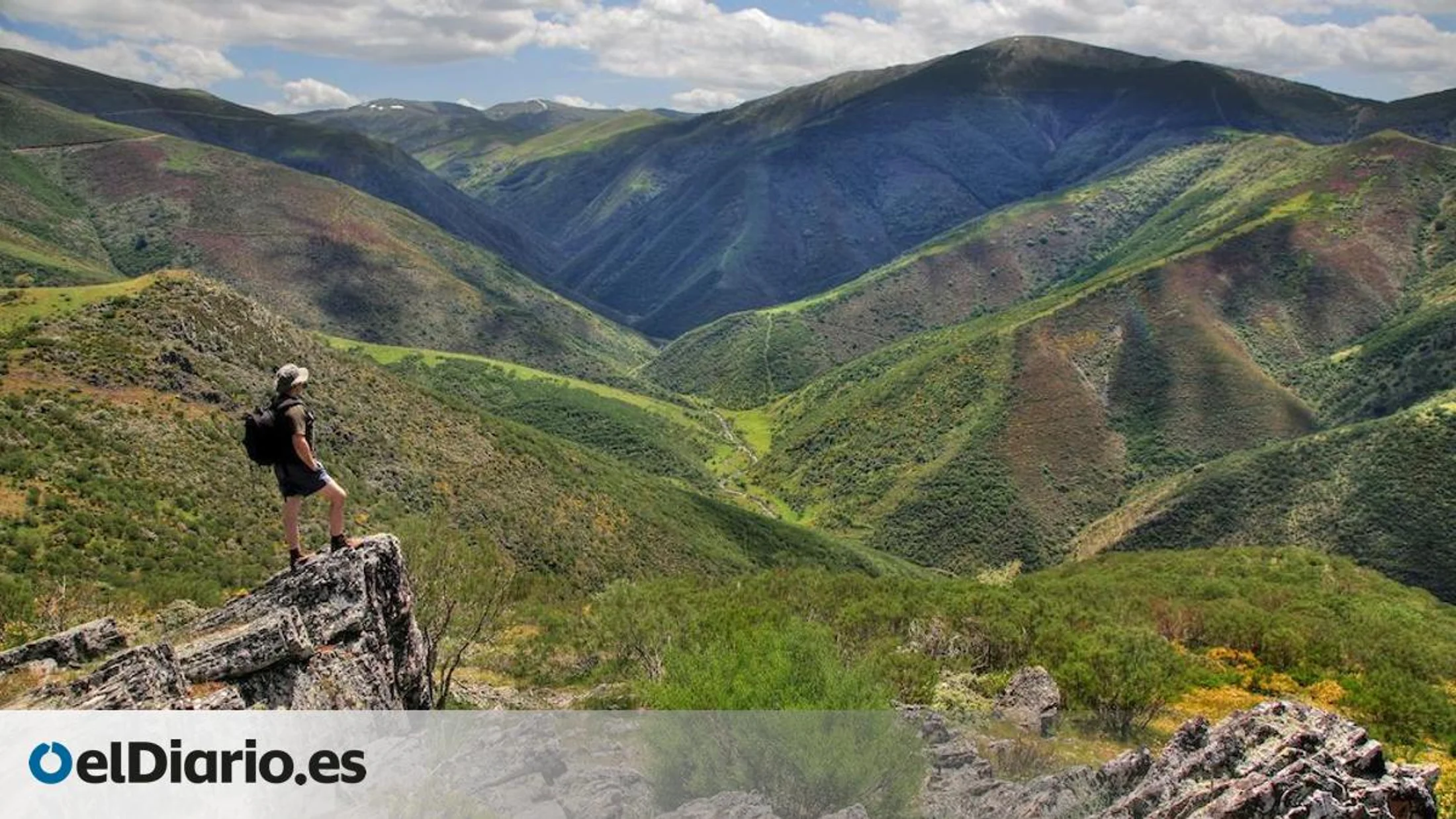
6) Sierra de la Demanda Trails: High Forests and La Rioja’s Roof
Southwest of Ezcaray, the Sierra de la Demanda rises to San Lorenzo (2,262 m), La Rioja’s highest peak, with beech, oak and pine hosting a web of trails. Choose half-day circuits in the Ezcaray valley (10–14 km, 400–700 m ascent) or a longer ascent day to San Lorenzo from Valdezcaray ski area. The air thins to the clean scent of resin and cold rock.
- Difficulty: Moderate to strenuous depending on route and weather; mountain footing with sustained climbs.
- Highlights: San Lorenzo summit views reaching the Ebro basin and, on clear days, the Pyrenees outline; spring carpets of anemones in beechwoods; autumn beech color; winter snowscapes.
- Best time: May–June and September–October for stable temperatures; summer is fine but start early; winter requires proper equipment and skills—snow and ice linger near summits.
- Multi-day: String together two days by basing in Ezcaray and linking valley circuits with ridgeline traverses; huts are sparse—plan lodging in towns.
- Weather: Conditions shift fast; check forecasts and turn around if storms build. Carry layers and a map even on short routes.
- Logistics: Road access to Valdezcaray and valley trailheads is straightforward; park in designated lots. Cell coverage is patchy on ridges.
Mountain note: Above treeline, winds can be bracing even in June, so pack an extra layer and gloves. The crunch of last spring’s beech leaves is a steady metronome underfoot.
7) Accessible Vineyard Walks Between Wineries: Easy Options for Everyone
If you want a gentle La Rioja vineyards hike with family members or limited mobility, choose short, mostly paved or graded paths connecting wineries and viewpoints around Haro, Briones, Cenicero and San Asensio. Distances run 2–5 km (45–90 minutes) with minimal ascent on wide surfaces. The sweet smell of crushed grape skins can drift from open cellar doors in harvest.
- Difficulty: Easy; suitable for families with strollers on selected segments and for visitors who prefer flat terrain. Always confirm accessibility directly with wineries for entrances and restroom access.
- Highlights: Riverbank promenades by the Ebro, town viewpoints with benches, heritage winery quarters and vine corridors just outside historic centers.
- Best time: Spring and autumn shine; summer is fine in the morning or evening; winter brings quiet paths and clear views.
- Activities: Tasting flights, guided tours of cellars, wine museums and picnic areas on municipal greenways. Tasting prices often range 8–25 € per person depending on the experience—confirm in advance.
- Logistics: Park on municipal lots; do not stop on vineyard tracks or turn areas. Public transport reaches Haro and many towns; taxis can shuttle between tasting stops if needed.
Responsible note: Walk between visits rather than drive after tastings, or designate a sober driver; the slow pace adds pleasure and safety. Sunlight pools golden on stone façades at day’s end.
Quick Planner and Map Tips
Use this quick planner to match a day, a fitness level and a landscape without overthinking it. Imagine a map with layered trails, parking and wineries you can toggle on and off.
-
Rioja Alta Vineyard Path (Haro–Briones–San Vicente)
- Location: Rioja Alta, north of the Ebro
- Distance/time: 8–12 km; 2.5–4 h; easy–moderate
- Best time: Spring bloom; harvest color
- Ideal for: Couples, photography, first-timers
- Highlights: River bends, castle views, “guardaviñas”
- Cost: Free; tastings 8–20 € (confirm current prices)
-
Hoces del Río Leza
- Location: Between Leza de Río Leza and Soto en Cameros (Biosphere Reserve)
- Distance/time: 10–12 km one-way; 3–4.5 h; moderate with exposure
- Best time: Spring/autumn
- Ideal for: Canyon lovers, hikers comfortable with heights
- Highlights: Vultures, balcony paths, limestone folds
- Cost: Free; parking in villages
-
Monastery of Valvanera Trail
- Location: Near Anguiano, Demanda foothills
- Distance/time: 8–10 km; 2.5–3.5 h; moderate
- Best time: Spring and autumn
- Ideal for: Culture-nature mix, families with teens
- Highlights: Abbey visit, beech and oak, streams
- Cost: Free access to trails; church usually free/donation
-
Sonsierra Ridge and Ebro Viewpoints
- Location: From San Vicente de la Sonsierra or Abalos
- Distance/time: 12–16 km; 4–5.5 h; moderate
- Best time: Spring/autumn; year-round feasible
- Ideal for: Photographers, wine travelers
- Highlights: Castle ridge, Ebro vistas, vine mosaics
- Cost: Free; wineries extra (book ahead)
-
Badén Ravine and Canyons (Cameros)
- Location: Central La Rioja (Cameros villages)
- Distance/time: 7–10 km; 3–4 h; moderate–challenging
- Best time: Spring/autumn dry spells
- Ideal for: Adventurous hikers, small groups
- Highlights: Rock chutes, scrambles, raptors
- Cost: Free; no services at trailhead
-
Sierra de la Demanda Circuits / San Lorenzo
- Location: Ezcaray valley, Valdezcaray area
- Distance/time: 10–20 km; 4–8 h; moderate–strenuous
- Best time: Late spring–early autumn; winter with snow gear
- Ideal for: Mountain hikers, multi-day planners
- Highlights: Beechwoods, ridgelines, far views
- Cost: Free; parking at ski area
-
Accessible Vineyard Walks (Haro, Briones, Cenicero, San Asensio)
- Location: Rioja Alta towns and outskirts
- Distance/time: 2–5 km; 45–90 min; easy
- Best time: Spring/autumn; mornings in summer
- Ideal for: Families, relaxed enotourism
- Highlights: River promenades, winery quarters
- Cost: Free paths; tastings or tours extra
Map tips:
- Use an interactive map app that allows offline downloads; load base layers plus “trails,” “parking,” “water” and “wineries” layers.
- Pin trailheads and public parking, and save winery stops to sequence walking segments between them.
- If available, load GPX/KML files from municipal tourism pages or from experiences curated on Picuco to reduce on-the-ground navigation time.
- Turn on terrain/shade relief for canyon and mountain routes, and slope gradient to anticipate effort.
As you plan, picture switching layers on and off like shutters opening to frame your day’s view.
How to Choose the Right Hiking La Rioja Route
Start with time: do you have 90 minutes, half a day or a full day? A short accessible vineyard loop near Haro or Briones fits a 90-minute window; the Rioja Alta Vineyard Path or Valvanera loop suits a half day; Sonsierra, Leza canyon or Demanda ridges fill a day. The soft rumble of the Ebro can be your metronome for shorter walks.
Match the route to your interests:
- If you want a La Rioja vineyards hike with winery visits, pick:
- Rioja Alta Vineyard Path for classic vine panoramas and flexible lengths.
- Accessible Vineyard Walks if traveling with kids, strollers or grandparents.
- If you seek gorges in La Rioja with a touch of exposure, pick:
- Hoces del Río Leza for balcony paths and vulture watching.
- Badén Ravine for short scrambles and sculpted rock corridors.
- If you crave mountain air and forest shade, pick:
- Sierra de la Demanda circuits and, if fit and prepared, San Lorenzo.
- Monastery of Valvanera for a culture-nature blend and cool woodland.
Factor in season and the best time to hike La Rioja:
- Spring (March–June): Wildflowers in vineyards; comfortable canyon and mountain temps.
- Summer (July–August): Early starts; prioritize forested or higher-altitude routes; keep vineyard strolls to mornings/evenings.
- Autumn (September–November): Harvest colors and activity; ideal for vines and canyons; reserve tastings early.
- Winter (December–February): Clear air and quiet vines; canyons icy in shade; mountains require winter skills.
Plan logistics and safety:
- Stay in hubs like Haro, Logroño or Ezcaray to minimize driving; string together two short vineyard segments with a tasting stop in between.
- Without a car, choose Haro or Logroño bases for train/bus access and taxi hops to trailheads; ask local tourism offices about current shuttle or guide services.
- For groups, align pace with the slowest hiker and choose loops with escape options. The smell of pine sap or crushed herbs often signals shade and rest ahead.
Practical Tips: Gear, Safety, Transport and Responsible Wine Visits
Essential gear for La Rioja routes
Pack for the terrain you choose and the season you’ll face. For vineyard paths: light hiking shoes with tread, a sun hat, sunglasses, sunscreen, 1–2 liters of water and a wind layer; vineyard tracks can be dusty and exposed. The crisp snap of dry grass underfoot reminds you to mind dehydration.
For gorges and canyons: sturdier boots with grip, fingerless gloves for scrambles, a small first-aid kit, 2 liters of water, a headlamp (in case of delays), and a helmet if entering narrow, rockfall-prone gullies. For mountains: layered clothing (base, mid, shell), warm hat and gloves year-round above 1,800 m, 2–2.5 liters of water, snacks with salt, and a map/compass or GPS; storms build fast over the Sierra de la Demanda.
Always carry:
- Navigation: phone with offline maps plus a power bank; consider a paper map backup.
- Sun and weather: sunscreen (SPF 50), lip balm, light rain shell even on clear days.
- Walking aids: trekking poles for long vineyard descents and mountain slopes.
- Winery add-ons: a compact tote or bottle protector if you intend to purchase wine and carry it safely; schedule tastings post-hike to avoid heat and impairment on trail.
Safety and rules in gorges and canyons
Canyon paths demand special care. Avoid narrow ledges in high winds, rain or snow; wet limestone becomes slick fast. If a section feels beyond your comfort, turn back—exposure means unprotected drop-offs where a stumble could be serious. Vulture shadows skim the walls like slow-moving sails.
Respect posted closures, especially during raptor nesting seasons (typically spring) or after landslides. Do not throw stones; groups below may be in the fall line. Keep voices low to avoid disturbing wildlife; if you encounter goats or sheep with a guardian dog, stop, speak calmly and give them space to pass.
Carry a small emergency kit (bandage, antiseptic, blister care) and know how to call 112, Spain’s emergency number, with a clear location description. In heat, rest in shade pockets, wet your hat and ration water. In winter, ice can linger in shaded slots—microspikes may be necessary, but if you don’t carry them, do not enter. If in doubt, consider a certified local guide for technical variants; operators with recognized qualifications work in the area.
Transport, parking and access
La Rioja is compact and car-friendly, but you can reach several routes with public transport. Renfe connects Logroño and Haro by train, and regional buses link Logroño with Haro, Nájera, Ezcaray, Anguiano and Cameros towns (verify seasonal schedules). Morning buses help you start vineyard or monastery walks without a vehicle. The metallic chime of a level crossing can mark the start of a car-free day.
By car: use signed municipal lots in Haro, Briones, San Vicente, Ezcaray and Valdezcaray. Never park on vineyard tracks, turnarounds or in front of farm gates; tractors have priority during harvest. In canyons, roadside pullouts fill quickly on weekends—arrive early or go midweek.
Combining routes in a day:
- Pair a dawn vineyard loop (2–3 h) with a late-morning tasting and a short river promenade.
- In Cameros, match a Badén Ravine outing (3–4 h) with a gentle Leza balcony viewpoint drive-and-walk.
- In Demanda, do a beechwood circuit, then stroll a flat riverside path near Ezcaray.
If you plan tastings, arrange a taxi for returns or designate a driver; distances between towns are short but rural roads are narrow and busy with tractors at times.
Responsible enotourism with vineyard routes
Walking through a working wine landscape is a privilege. Stay on marked tracks; never cut across rows or sit on stone walls, which are part of field infrastructure. The warm, earthy scent rising from cultivated soil is a sign of care—respect it.
Book winery visits in advance, especially on weekends and during harvest. Ask about tour times and accessibility; allow 60–90 minutes per visit without rushing. Taste responsibly:
- Schedule tastings after your hike to avoid heat and impairment on trail.
- Use a spit cup if driving later; consider a single shared tasting flight for couples pre-lunch.
- Do not drive after multiple tastings; opt for taxis or walk between nearby wineries.
Support the local economy by buying a bottle, enjoying seasonal menus in village restaurants and choosing rural accommodations. Reduce waste: carry a reusable bottle, pack out all litter and avoid glass on rural tracks. Share kind words with vineyard workers if you cross paths; they are the stewards of this landscape. The clink of a bottle into your tote can be a promise to remember the valley with dinner back home.
Frequently Asked Questions
When is the best time to hike La Rioja?
Spring (March–June) and autumn (September–November) offer mild temperatures, flowers and harvest colors. Summer is fine with early starts, shade and water; winter brings quiet vines but ice in canyons and snow in the Sierra de la Demanda.
Are the gorges in La Rioja safe for families?
Hoces and ravines include narrow paths and exposure; families with experienced teens do well, but small children need close supervision and should avoid the most exposed ledges. Choose wider balcony sections, go early and turn back if anyone feels uneasy.
Do I need a guide for these Rioja hiking trails?
Most vineyard and monastery routes are straightforward without a guide if you carry a map or GPX. For technical canyon variants or winter mountain ascents, a certified local guide adds safety and context; ask about qualifications and group sizes.
Can I combine hiking with winery visits in one day?
Yes—do a morning vineyard loop, book a midday or afternoon tasting and add a short river promenade. Always reserve visits and plan transport so you are not driving after multiple tastings.
Are there permits or fees for these routes?
Public trails are generally free, with parking in municipal lots. Monastery visits may request donations. Temporary restrictions can affect canyon areas during nesting or after rockfall; respect posted notices.
How can I reach trailheads without a car?
Base in Haro, Logroño or Ezcaray. Trains serve Logroño and Haro; regional buses reach Rioja Alta towns, Anguiano and Cameros hubs. From bus stops, you can walk to vineyard routes or take a short taxi to canyon and monastery trailheads.
What gear should I bring for vineyard, canyon and mountain routes?
For vineyards: light hiking shoes, sun protection and 1–2 liters of water. For canyons: grippy boots, gloves, 2 liters of water and a helmet if entering narrow gullies. For mountains: layered clothing, map/GPS, 2–2.5 liters of water and snacks.
Can I walk through vineyards during harvest?
Yes, but stay on public or marked farm tracks and give way to tractors. Avoid blocking entrances, keep dogs on a lead and do not pick grapes. Harvest adds color and energy—plan extra time for pauses and photos.
Reserve your experience — discover active tourism across Spain with providers verified by Picuco.
Conclusion
Hiking La Rioja draws a single thread through vineyards, gorges and mountains, letting you taste a place with your feet before you taste it in a glass. You can start with an easy La Rioja vineyards hike, step into the shadowed drama of the Leza canyon the next day and finish on a beech-lined ridge in the Sierra de la Demanda. The region rewards slow travel, quiet observation and a willingness to let rural rhythms set your pace. Evening light lingers like amber on stone and leaf.
Plan according to season and energy, pair walks with thoughtful visits and meals, and treat vineyard tracks and canyon ledges with respect. If you want more detail, explore curated activities by region and save routes to a map for an easy weekend plan. Share your favorite overlooks and village finds with fellow travelers, and above all, leave paths and vines as you found them so others can experience the same calm and clarity. The landscapes of La Rioja repay care with memory-rich days you will want to repeat.